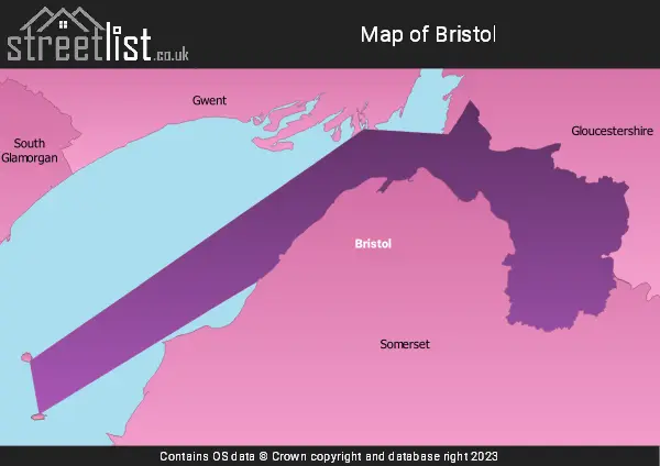
The Ceremonial County of Bristol is situated in South West England.
The area of Bristol is 91 Square Miles (235 Square Kilometres). Making Bristol the 6th smallest county in Great Britain (out of 91) and the 2nd smallest county in England (out of 48).

A map showing the geology of Bristol.
| Map Key | Description |
|---|---|
| 18 | MUDSTONE, SILTSTONE, LIMESTONE AND SANDSTONE |
| 21 | MUDSTONE, SILTSTONE AND SANDSTONE |
| 27 | SANDSTONE AND CONGLOMERATE, INTERBEDDED |
| 37 | MUDSTONE, SILTSTONE, SANDSTONE, COAL, IRONSTONE AND FERRICRETE |
| 41 | LIMESTONE WITH SUBORDINATE SANDSTONE AND ARGILLACEOUS ROCKS |

A map showing the boundary of Bristol in relation to other counties.
Advertisement
Map of the County of Bristol
| Zoom Level | Latitude | Longitude |
| 6 | 53.521968 | -2.164306 |
Cities, Towns and Villages in Bristol
| Town Name | Number of Streets |
|---|---|
| BRISTOL | 11119 |
| Clifton | 767 |
| Westbury-on-Trym | 601 |
| Bedminster | 565 |
| Fishponds | 476 |
| Redland | 436 |
| Horfield | 426 |
| St. George | 378 |
| Bishopston | 355 |
| Southville | 344 |
| Easton | 333 |
| Kingswood | 318 |
| Eastville | 295 |
| Brislington | 266 |
| Cotham | 263 |
| Bishopsworth | 257 |
| Redfield | 246 |
| St. Andrews | 237 |
| Stoke Bishop | 204 |
| Shirehampton | 192 |
| Montpelier | 186 |
| Henbury | 184 |
| Knowle | 176 |
| Whitchurch | 172 |
| Henleaze | 170 |
| St. Annes Park | 159 |
| Totterdown | 145 |
| St. Philips | 141 |
| Tyndalls Park | 122 |
| Brentry | 117 |
| Southmead | 107 |
| Avonmouth | 102 |
| Lawrence Hill | 99 |
| Broomhill | 79 |
| St. Werburghs | 77 |
| Temple Meads | 76 |
| Ashley Down | 76 |
| Arnos Vale | 71 |
| Stapleton | 66 |
| Whitehall | 66 |
| Whiteway | 60 |
| Coombe Dingle | 58 |
| Barton Hill | 57 |
| Staple Hill | 56 |
| Lawrence Weston | 52 |
| Greenbank | 50 |
| Crofts End | 44 |
| Bedminster Down | 40 |
| Hawkfield Business Park | 34 |
| Clay Hill | 26 |
| Burchells Green | 25 |
| Keynsham | 25 |
| Redcliffe | 23 |
| Durdham Park | 23 |
| Stockwood | 21 |
| Downend | 20 |
| Chester Park | 17 |
| Kingsweston | 15 |
| Chittening | 14 |
| Sea Mills | 13 |
| Sneyd Park | 13 |
| Pylle Hill | 8 |
| Hengrove | 7 |
| Hallen | 7 |
| Portishead | 4 |
| St. Annes | 4 |