The Ceremonial County of Surrey in England

The Ceremonial County of Surrey is situated in South East England.

a map of Surrey

The area of Surrey is 645 Square Miles (1,670 Square Kilometres). Making Surrey the 37th smallest county in Great Britain (out of 91) and the 14th smallest county in England (out of 48).

The Saxons divided southern England into four tribes: the East Saxons (Essex), South Saxons (Sussex), West Saxons (Wessex), and Middle Saxons. Surrey derives its name from the southern part of the Middle Saxon territory, meaning 'southern region,' while the northern area became Middlesex.

Surrey's ancient roads include the Pilgrims' Way, crossing the county through Farnham and Dorking on the route to Canterbury. Stane Street, the Roman road from London to Chichester, also ran through Dorking. The county has long been connected to London, and William Shakespeare even built the original Globe Theatre in Surrey (Bankside, then part of Surrey, built in 1599).

The chalk ridge known as the Hogs Back runs east to west, bisecting the county. The area west of the River Wey and north of the Hogs Back was once part of Windsor Forest, a royal hunting ground.

Surrey historically fell under the jurisdiction of the Bishop of Winchester until 1877. Today, Guildford, with its modern cathedral, is the county town, though earlier Surrey's administrative centres were Newington and Kingston upon Thames, now part of Greater London.

Surrey was divided into 14 Hundreds, including Farnham, Woking, Godalming, Reigate, and Kingston. Modern Surrey differs significantly from its historical borders, with much of south London, including Surrey Quays in Rotherhithe, formerly part of the county.

During the English Civil War, Surrey largely supported Parliament, contributing to its success with iron foundries and gunpowder works at Chilworth. However, the county faced heavy taxes and losses. In 1648, the Earl of Holland led a brief insurrection, clashing with Parliamentary forces at Surbiton.

Surrey's economy once thrived on iron and cloth, but agriculture grew as London's demand for food increased. The River Wey was canalised in 1653, becoming one of England's first navigable waterways. As London expanded, much of Surrey was absorbed into its suburbs.

Geological Map of Surrey

A map showing the geology of Surrey.

Geological Makeup of Surrey
Map Key Description
21 MUDSTONE, SILTSTONE AND SANDSTONE
28 SAND, SILT AND CLAY
30 CHALK
48 MUDSTONE, SANDSTONE AND LIMESTONE
57 SANDSTONE AND MUDSTONE
76 SANDSTONE AND SILTSTONE, INTERBEDDED
79 CLAY, SILT, SAND AND GRAVEL
Map of Surrey

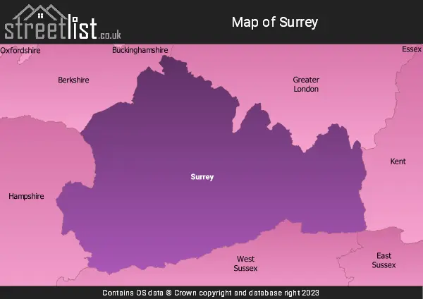
A map showing the boundary of Surrey in relation to other counties.

Advertisement

Map of the County of Surrey

Zoom LevelLatitudeLongitude
653.521968-2.164306
Cities, Towns and Villages in Surrey
Town Name Number of Streets
GUILDFORD2019
WOKING1743
EPSOM1183
REDHILL991
FARNHAM967
Ewell875
STAINES-UPON-THAMES865
CAMBERLEY857
REIGATE799
GODALMING766
Epsom746
Walton-on-Thames744
WEYBRIDGE728
HORLEY666
Ashford638
ADDLESTONE621
DORKING620
LEATHERHEAD591
CATERHAM580
COBHAM556
Sunbury-on-Thames529
CHERTSEY469
ASHTEAD426
CRANLEIGH426
Great Bookham415
Frimley414
HASLEMERE386
OXTED380
Esher360
TADWORTH352
SHEPPERTON350
Fetcham335
EGHAM332
Banstead323
Knaphill323
Farncombe306
Ash305
Englefield Green298
WARLINGHAM293
WEST MOLESEY278
Ash Vale278
Hersham275
HINDHEAD243
WEST BYFLEET243
Byfleet227
Wrecclesham224
New Haw222
Merstham219
Long Ditton215
East Molesey210
BAGSHOT209
East Horsley191
Thames Ditton186
VIRGINIA WATER184
Chobham183
Stanwell179
Ottershaw179
Nork172
Claygate164
South Merstham163
Lower Bourne159
West End152
Effingham147
Great Burgh146
Send145
Chiddingfold144
Kingswood143
WHYTELEAFE143
Oxshott141
West Horsley141
LIGHTWATER139
Woodham137
Little Bookham133
Ripley128
Felbridge125
Churt125
LINGFIELD124
Milford122
Hinchley Wood122
Lower Kingswood121
WINDLESHAM119
Walton On The Hill118
Tongham117
Bramley117
Frimley Green116
Tatsfield112
Bisley109
Pyrford109
GODSTONE109
Worplesdon103
Row Town102
Jacob's Well102
Shalford101
Deepcut101
Stoneleigh101
Woodmansterne99
Old Woking96
Witley94
Shepperton Green94
West Clandon94
Elstead93
BETCHWORTH92
ASCOT90
Brookwood90
Bletchingley89
Woldingham84
Ashford Common84
North Holmwood84
Beacon Hill82
Smallfield82
Albury82
Brockham78
Horsell77
Ewhurst76
Westcott76
Rowledge75
Seale73
Lyne73
Frensham73
Mytchett72
Chipstead70
Beare Green70
South Nutfield69
Wormley69
Copthorne68
Headley68
Upper Halliford68
Burpham68
Badshot Lea67
Dormansland67
Hambledon67
Salfords67
Chaldon67
Sheerwater67
Pirbright66
Ockley65
Longcross65
Hog Hatch64
Brooklands63
Charlwood62
Burgh Heath61
Trumps Green61
Shere61
Pixham59
Weybourne58
Capel58
Normandy58
Wood Street Village57
Wonersh57
COULSDON56
Slyfield Industrial Estate56
Boundstone54
Chilworth54
Hale54
Ash Green54
Burwood Park54
Heath End54
Thursley54
Compton53
Dunsfold53
Burntcommon51
Hookwood51
Grayshott50
Leigh50
Wentworth49
Box Hill49
Nutfield49
The Sands47
Tilford46
Shortheath46
Lower Hale46
Dockenfield45
Gomshall44
Abinger Hammer44
Whiteley Village44
Wyke44
Peaslake43
Stoke D'Abernon43
Blindley Heath42
Alfold42
Fairlands41
Mickleham41
Flexford41
Shamley Green40
Grayswood39
South Godstone39
Epsom Downs38
Bourne Business Park38
Old Windsor37
Hurtmore37
Mayford37
Langley Vale37
Surrey Research Park36
Puttenham36
Outwood35
Newdigate35
Mid Holmwood35
Abinger Common34
Limpsfield33
St. Johns32
Penton Hook32
Brooklands Industrial Park32
Wotton31
ALDERSHOT31
Netherne on-the-Hill31
Rushmoor31
Hascombe30
Shackleford29
Mousehill28
Cramhurst28
East Clandon28
Holmbury St. Mary27
EDENBRIDGE27
Littleton27
Newchapel27
Thorpe27
Runfold27
Busbridge27
Westhumble26
Send Marsh26
Peasmarsh25
Charlton25
Buckland24
Enton24
Bramshott Chase24
Littleton Common23
Ockham23
Rudgwick22
West Bedfont22
Tandridge22
EAST GRINSTEAD22
Weston Green22
Sutton Abinger21
Ramsnest Common21
Felcourt20
Dormans Park20
Horne20
Holmwood20
Hooley20
Binscombe20
Stroude20
Hydestile19
Alfold Crossways19
Donkey Town19
Willey Green19
St. Georges Hill19
Hoe18
Mimbridge18
Brook18
Worplesdon Hill18
Farley Green18
Strood Green18
Upper Hale18
Parkgate18
Millbridge18
Artington17
Shortfield Common17
Walliswood16
WESTERHAM15
South Holmwood15
Elmbridge Village15
Keeper's Corner14
The Chart14
Titsey14
Thorpe Industrial Estate14
Downside14
The Bourne13
Crowhurst13
Thorpe Green12
Castle Green12
Loxhill12
Loxwood12
Pyle Hill11
Thorncombe Street11
Ewshot11
Sutton Green11
Effingham Junction11
Sandy Cross10
Anglefield Corner10
Sidlow10
Burstow10
Woldingham Garden Village10
Dippenhall9
Marsh Green9
Wisley9
Bunce Common9
Pyrford Green9
Forest Green9
Coldharbour9
Blackheath8
Sandhills8
Pachesham Park8
Royal Military Academy8
Margery8
Stanford Common8
Lingfield Common7
Sheet's Heath7
Wraysbury6
Brick Hill6
Cowden6
Upper Eashing6
Pains-Hill5
Compton5
Mogador5
Burwood Park5
Chelsham5
Peper Harow5
Bowlhead Green4
Gatton4
Pitland Street3
Enton Green3
Lower Eashing3
Cudworth3
Runwick3
Ranmore Common3
Norney3
Okewood Hill2
Nutcombe2
Wanborough2
Shipley Bridge2
Norwood Hill2
Leith Hill2
Rusper1
Skimmington1