
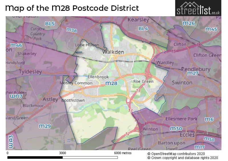
Map of the M28 Postcode District
Explore the postcode district by using our interactive map.
Circles represent recorded crime; the larger the circle, the higher the crime rates.
Your support helps keep this site running!
If you enjoy using this website, consider buying me a coffee to help cover hosting costs.
Where is the M28 District?
To give you an idea where the district is located we have created the following table showing nearby towns.
Nearest Towns to M28
| Town | Distance (miles) | Direction |
|---|---|---|
| Kearsley | 2.41 | NNE |
| Swinton | 2.43 | E |
| Tyldesley | 2.86 | W |
| Farnworth | 2.96 | N |
| Eccles | 3.04 | SE |
| Atherton | 3.85 | WNW |
| Urmston | 3.86 | SSE |
| Irlam | 3.89 | S |
| Little Lever | 3.90 | NNE |
| Salford | 4.67 | ESE |
| Radcliffe | 4.71 | NE |
| Leigh | 5.00 | W |
| Bolton | 5.02 | NNW |
| Whitefield | 5.15 | ENE |
| Stretford | 5.69 | SE |
| Westhoughton | 5.85 | WNW |
| Partington | 6.25 | S |
| Sale | 6.51 | SSE |
The post town for this district is MANCHESTER.
Postcode Information for District M28 (Total Geographical Postcodes: 1516)
| Location | Post Town | Sector | Number of Postcodes |
|---|---|---|---|
| Worsley | MANCHESTER | M28 3 | 499 |
| Worsley | MANCHESTER | M28 1 | 318 |
| Worsley | MANCHESTER | M28 7 | 308 |
| Worsley | MANCHESTER | M28 2 | 225 |
| Worsley | MANCHESTER | M28 0 | 166 |
Retail and Shopping in M28
Street
Town
Locality
Number of Shops
Central Postcode
View on Google Maps
BOLTON ROAD
MANCHESTER
WORSLEY
142
M28 3ZD
View on Google Maps
WALKDEN ROAD
MANCHESTER
WORSLEY
27
M28 7DP
View on Google Maps
HULTON DISTRICT CENTRE
MANCHESTER
WORSLEY
22
M28 0AU
View on Google Maps
MANCHESTER ROAD
MANCHESTER
WORSLEY
20
M28 3HH
View on Google Maps
NEW ELLESMERE APPROACH
MANCHESTER
WORSLEY
18
M28 3UD
View on Google Maps
LEIGH ROAD
MANCHESTER
WORSLEY
17
M28 1HP
View on Google Maps
SIMPSON ROAD
MANCHESTER
WORSLEY
15
M28 1LT
View on Google Maps
MOSLEY COMMON ROAD
MANCHESTER
WORSLEY
10
M28 1AH
View on Google Maps
RYDAL CRESCENT
MANCHESTER
WORSLEY
10
M28 7JD
View on Google Maps
BRIDGEWATER ROAD
MANCHESTER
WORSLEY
9
M28 3JE
View on Google Maps
MEMORIAL ROAD
MANCHESTER
WORSLEY
9
M28 3AG
View on Google Maps
WORSLEY ROAD NORTH
MANCHESTER
WORSLEY
9
M28 3GW
View on Google Maps
BARTON ROAD
MANCHESTER
WORSLEY
7
M28 2PD
View on Google Maps
CHADDOCK LANE
MANCHESTER
WORSLEY
7
M28 1DE
View on Google Maps
MANCHESTER ROAD EAST
MANCHESTER
LITTLE HULTON
7
Coordinates unavailable
HIGH STREET
MANCHESTER
WORSLEY
6
M28 3NJ
View on Google Maps
MORSTON CLOSE
MANCHESTER
WORSLEY
6
M28 1PB
View on Google Maps
| Street | Town | Locality | Number of Shops | Central Postcode | View on Google Maps |
|---|---|---|---|---|---|
| BOLTON ROAD | MANCHESTER | WORSLEY | 142 | M28 3ZD | View on Google Maps |
| WALKDEN ROAD | MANCHESTER | WORSLEY | 27 | M28 7DP | View on Google Maps |
| HULTON DISTRICT CENTRE | MANCHESTER | WORSLEY | 22 | M28 0AU | View on Google Maps |
| MANCHESTER ROAD | MANCHESTER | WORSLEY | 20 | M28 3HH | View on Google Maps |
| NEW ELLESMERE APPROACH | MANCHESTER | WORSLEY | 18 | M28 3UD | View on Google Maps |
| LEIGH ROAD | MANCHESTER | WORSLEY | 17 | M28 1HP | View on Google Maps |
| SIMPSON ROAD | MANCHESTER | WORSLEY | 15 | M28 1LT | View on Google Maps |
| MOSLEY COMMON ROAD | MANCHESTER | WORSLEY | 10 | M28 1AH | View on Google Maps |
| RYDAL CRESCENT | MANCHESTER | WORSLEY | 10 | M28 7JD | View on Google Maps |
| BRIDGEWATER ROAD | MANCHESTER | WORSLEY | 9 | M28 3JE | View on Google Maps |
| MEMORIAL ROAD | MANCHESTER | WORSLEY | 9 | M28 3AG | View on Google Maps |
| WORSLEY ROAD NORTH | MANCHESTER | WORSLEY | 9 | M28 3GW | View on Google Maps |
| BARTON ROAD | MANCHESTER | WORSLEY | 7 | M28 2PD | View on Google Maps |
| CHADDOCK LANE | MANCHESTER | WORSLEY | 7 | M28 1DE | View on Google Maps |
| MANCHESTER ROAD EAST | MANCHESTER | LITTLE HULTON | 7 | Coordinates unavailable | |
| HIGH STREET | MANCHESTER | WORSLEY | 6 | M28 3NJ | View on Google Maps |
| MORSTON CLOSE | MANCHESTER | WORSLEY | 6 | M28 1PB | View on Google Maps |
The primary settlement in the M28 postcode district is Worsley, located in Greater Manchester. Other significant settlements in this district include Manchester. The primary post town is Manchester in the county of Greater Manchester.
When it comes to local government, postal geography often disregards political borders. However, this district intersects the following councils: the district mostly encompasses the Salford District (B) (1026 postal codes), and finally, the Wigan District (B) area (73 postal codes).
The M28 postal code covers the settlement of Worsley.
The M28 Postcode shares a border with M38 (Little Hulton), M27 (Swinton), M29 (Tyldesley), M30 (Eccles) and BL4 (Farnworth, Kearsley).


Dentists in the M28 District
| # | Name | Address | Type | Contact |
|---|---|---|---|---|
| 1 | Hewitt, Higgins, Sadler & Hamburger | 10 - 12 MEMORIAL ROAD , WORSLEY , MANCHESTER , LANCASHIRE , M28 3AQ | GENERAL DENTAL PRACTICE | |
| 2 | Leigh Road (dental Surgery) | 51 LEIGH ROAD , WORSLEY , MANCHESTER , LANCASHIRE , M28 1HP | GENERAL DENTAL PRACTICE | |
| 3 | Walkden Health And Social Care C | 2 SMITH STREET , WORSLEY , MANCHESTER , M28 3EZ | GENERAL DENTAL PRACTICE | |
| 4 | Meridian Dental Clinic | 4 THE PACKET HOUSE AND BOATSTEPS , BARTON ROAD , WORSLEY , MANCHESTER , GREATER MANCHESTER , M28 2PB | GENERAL DENTAL PRACTICE | |
| 5 | Pennyblack Dental | PENNYBLACK COURT , WORSLEY , MANCHESTER , M28 2PD | GENERAL DENTAL PRACTICE |
Doctors in the M28 District
| # | Name | Address | Type | Contact |
|---|---|---|---|---|
| 1 | Salford Primary Care Together | , WORSLEY , MANCHESTER , M28 0BB | GP PRACTICE | |
| 2 | Walkden Medical Centre | , WALKDEN , WORSLEY , MANCHESTER , GREATER MANCHESTER , M28 3AT | GP PRACTICE | |
| 3 | The Limes Medical Practice | , WORSLEY , MANCHESTER , LANCASHIRE , M28 3AT | GP PRACTICE | |
| 4 | The Gill Medical Practice | , WORSLEY , WALKDEN , MANCHESTER , LANCASHIRE , M28 3DR | GP PRACTICE | |
| 5 | Ellenbrook Medical Centre | , WORSLEY , MANCHESTER , GREATER MANCHESTER , M28 1PB | GP PRACTICE | |
| 6 | Dearden Avenue Medical Practice | , 4 LONGSHAW DRIVE , WORSLEY , MANCHESTER , M28 0BB | GP PRACTICE | |
| 7 | Orchard Medical Practice | , WORSLEY , BOOTHSTOWN , MANCHESTER , LANCASHIRE , M28 1LZ | GP PRACTICE | |
| 8 | Cherry Medical Practice | , HAYSBROOK AVENUE , WORSLEY , MANCHESTER , LANCASHIRE , M28 0AY | GP PRACTICE | |
| 9 | Manchester Road East Medical Practice | , 4 LONGSHAW DRIVE , WORSLEY , MANCHESTER , M28 0BB | GP PRACTICE | |
| 10 | Salford Primary Care Together - Little Hulton | , HAYSBROOK AVENUE , WORSLEY , MANCHESTER , GREATER MANCHESTER , M28 0AY | BRANCH SURGERY | |
| 11 | Oakbank Medical Centre | , 2 SMITH STREET , WORSLEY , MANCHESTER , M28 3EZ | BRANCH SURGERY | |
| 12 | Little Hulton Medical Centre - Covid Local Vaccination Service | , WORSLEY , MANCHESTER , M28 0BB | BRANCH SURGERY |
Chemists in the M28 District
| # | Name | Address | Type | Contact |
|---|---|---|---|---|
| 1 | Tesco Instore Pharmacy | 60 ELLESMERE CENTRE , WALKDEN , MANCHESTER , GREATER MANCHESTER , M28 3BT | PHARMACY | |
| 2 | Tims & Parker Pharmacy | 29-31 BOLTON ROAD , WORSLEY , MANCHESTER , GREATER MANCHESTER , M28 3AX | PHARMACY | |
| 3 | Tims & Parker Pharmacy | 3 STANDFIELD CENTRE , BOOTHSTOWN , WORSLEY , MANCHESTER , GREATER MANCHESTER , M28 1FB | PHARMACY | |
| 4 | Boots | UNIT FF2 , ELLESMERE SHOPPING CENTRE , WALKDEN , MANCHESTER , LANCASHIRE , M28 3ZD | PHARMACY | |
| 5 | Tims & Parker Pharmacy | 12 MORSTON CLOSE , ELLENBROOK MEDICAL CENTRE , WORSLEY , MANCHESTER , GREATER MANCHESTER , M28 1PB | PHARMACY | |
| 6 | Tims & Parker Pharmacy | 1 HULTON DISTRICT CENTRE , LITTLE HULTON , WORSLEY , MANCHESTER , GREATER MANCHESTER , M28 0BA | PHARMACY | |
| 7 | Tims & Parker Pharmacy | 4 HODGE ROAD , WALKDEN , MANCHESTER , GREATER MANCHESTER , M28 3AT | PHARMACY | |
| 8 | Pillo | UNIT 25 OAKHILL TRAD.EST. , 61 DEVONSHIRE RD , WORSLEY , MANCHESTER , M28 3PT | PHARMACY |
Opticians in the M28 District
| # | Name | Address | Type | Contact |
|---|---|---|---|---|
| 1 | WALKDEN EXTRA | ELLESMERE SHOPPING CENTRE , WALKDEN , MANCHESTER , GREATER MANCHESTER , M28 3BT | OPTICAL SITE | |
| 2 | YATES & SUDDELL OPTICIANS (WALKDEN) | UNIT 144 LADY HARRIET WALK , ELLESMERE SHOPPING CENTRE , BOLTON ROAD, WORSLEY , MANCHESTER , GREATER MANCHESTER , M28 3ZH | OPTICAL SITE | |
| 3 | DISTRICT OPTICIANS (WORSLEY) | 14 HULTON DISTRICT CENTRE , WORSLEY , MANCHESTER , GREATER MANCHESTER , M28 0AU | OPTICAL SITE | |
| 4 | WALKDEN EYE CENTRE | 14 HODGE ROAD , WORSLEY , MANCHESTER , GREATER MANCHESTER , M28 3AT | OPTICAL SITE | |
| 5 | SPECSCART (ELLESMERE SHOPPING CENTRE ) | UNIT 79, ELLESMERE SHOPPING CENTRE , BOLTON ROAD , WORSLEY , MANCHESTER , GREATER MANCHESTER , M28 3ZD | OPTICAL SITE | |
| 6 | PRAIS OPTICIANS (BOOTHSTOWN) | 9 STANDFIELD CENTRE , WORSLEY , MANCHESTER , M28 1FB | OPTICAL SITE | |
| 7 | ROBIN HALL OPTICIANS | 3 BRIDGEWATER ROAD , WORSLEY , MANCHESTER , GREATER MANCHESTER , M28 3JE | OPTICAL SITE |
Schools in the Sector
Hilton Lane Primary School
Phase: Primary
Address: Madams Wood Road , Little Hulton , Worsley , Manchester
Postcode: M28 0JY
Headteacher: Miss Hayley Kearsley (Headteacher)
Ofsted Rating: Good
Harrop Fold School
Phase: Secondary
Address: Hilton Lane , Worsley , Manchester
Postcode: M28 0SY
Headteacher: Mrs Claire Coy (Headteacher)
Ofsted Rating: Special Measures
St Andrew's Methodist Primary School
Phase: Primary
Address: Prescott Street , Off Hilton Lane , Worsley , Manchester
Postcode: M28 0ZA
Headteacher: Mrs Anne Barker (Headteacher)
Ofsted Rating: Outstanding
St John's CofE Primary School Mosley Common
Phase: Primary
Address: Commonside Road , Worsley , Manchester
Postcode: M28 1AE
Headteacher: Miss Andrea Heaton (Headteacher)
Ofsted Rating: Good
Holy Family Catholic Primary School
Phase: Primary
Address: Kendal Road , Boothstown , Worsley , Manchester
Postcode: M28 1AG
Headteacher: Mrs Clare Roberts (Headteacher)
Ofsted Rating: Good
Boothstown Methodist Primary School
Phase: Primary
Address: 6 Chapel Street , Boothstown , Worsley , Manchester
Postcode: M28 1DG
Headteacher: Miss Karen Armfield (Headteacher)
Ofsted Rating: Good
St Andrew's CofE Primary School
Phase: Primary
Address: Vicars Hall Lane , Boothstown , Worsley , Manchester
Postcode: M28 1HS
Headteacher: Mr Michael Platt (Headteacher)
Ofsted Rating: Outstanding
St Mark's CofE Primary School
Phase: Primary
Address: Aviary Road , Walkden , Worsley , Manchester
Postcode: M28 2WF
Headteacher: Mrs Louise Mansfield (Headteacher)
Ofsted Rating: Good
Christ The King RC Primary School
Phase: Primary
Address: Holly Avenue , Worsley , Manchester
Postcode: M28 3DW
Headteacher: Mrs Nichola Potts (Headteacher)
Ofsted Rating: Good
St Paul's CofE Primary School
Phase: Primary
Address: Crompton Street , Walkden , St. Pauls C of E Primary School , Manchester
Postcode: M28 3HP
Headteacher: Ms Rosie Knipe (Headteacher)
Ofsted Rating: Good
St Paul's CofE Primary School
Phase: Primary
Address: Heathside Grove , Walkden , Worsley , Manchester
Postcode: M28 3NZ
Headteacher: Mrs Joanne Rowley (Acting Headteacher)
Ofsted Rating: Good
North Walkden Primary School
Phase: Primary
Address: Worsley Road North , Walkden , Worsley , Manchester
Postcode: M28 3QD
Headteacher: Mrs Helen Warburton (Headteacher)
Ofsted Rating: Good
Mesne Lea Primary School
Phase: Primary
Address: Walkden Road , Walkden , Worsley , Manchester
Postcode: M28 7FG
Headteacher: Mrs Victoria Unsworth (Headteacher)
Ofsted Rating: Good
James Brindley Community Primary School
Phase: Primary
Address: Parr Fold Avenue , Walkden , Worsley , Manchester
Postcode: M28 7HE
Headteacher: Mr Chris Moore (Headteacher)
Ofsted Rating: Outstanding
Walkden High School
Phase: Secondary
Address: Old Clough Lane , Walkden , Worsley , Manchester
Postcode: M28 7JB
Headteacher: Mr Simon Lennox (Headteacher)
Ofsted Rating: Requires improvement
Co-op Academy Walkden
Phase: Secondary
Address: Old Clough Lane , Walkden , Worsley , Manchester
Postcode: M28 7JB
Headteacher: Mr Matt Hacker (Headteacher)
Ofsted Rating: Good
Ellenbrook Community Primary School
Phase: Primary
Address: Longwall Avenue , Ellenbrook , Worsley , Manchester
Postcode: M28 7PS
Headteacher: Mr Roger Blackburn (Headteacher)
Ofsted Rating: Outstanding
Stations in the Sector
Walkden
CRS Code: WKD
Operator: NT
Line: Manchester Southport Line
Company: Northern
Accessable Motorway Junctions
M60 J13
Average Driving Time from within the district: 3.66
Average Driving Distance: 1.68
Number of Postcodes that can access the Motorway Junction: 833
M60 J12
Average Driving Time from within the district: 3.95
Average Driving Distance: 2.33
Number of Postcodes that can access the Motorway Junction: 348
M60 J15
Average Driving Time from within the district: 4.06
Average Driving Distance: 2.51
Number of Postcodes that can access the Motorway Junction: 445
M60 J14
Average Driving Time from within the district: 4.14
Average Driving Distance: 2.07
Number of Postcodes that can access the Motorway Junction: 1058
M602 J1
Average Driving Time from within the district: 4.17
Average Driving Distance: 2.45
Number of Postcodes that can access the Motorway Junction: 375
M61 J1
Average Driving Time from within the district: 4.23
Average Driving Distance: 2.59
Number of Postcodes that can access the Motorway Junction: 616
M62 J12
Average Driving Time from within the district: 4.44
Average Driving Distance: 2.70
Number of Postcodes that can access the Motorway Junction: 373
M60 J16
Average Driving Time from within the district: 5.04
Average Driving Distance: 2.27
Number of Postcodes that can access the Motorway Junction: 7
M61 J5
Average Driving Time from within the district: 5.28
Average Driving Distance: 3.43
Number of Postcodes that can access the Motorway Junction: 1
M61 J3
Average Driving Time from within the district: 5.46
Average Driving Distance: 2.45
Number of Postcodes that can access the Motorway Junction: 512
M61 J4
Average Driving Time from within the district: 5.67
Average Driving Distance: 2.73
Number of Postcodes that can access the Motorway Junction: 138
M60 J11
Average Driving Time from within the district: 6.56
Average Driving Distance: 3.97
Number of Postcodes that can access the Motorway Junction: 8
M61 J2
Average Driving Time from within the district: 7.21
Average Driving Distance: 4.76
Number of Postcodes that can access the Motorway Junction: 721
Weather Forecast for Worsley
| Time Period | Icon | Description | Temperature | Rain Probability | Wind |
|---|---|---|---|---|---|
| 18:00 to 21:00 | Cloudy | 5.0°C (feels like 2.0°C) | 4.00% | SSE 9 mph | |
| 21:00 to 00:00 | Cloudy | 5.0°C (feels like 2.0°C) | 8.00% | SSE 9 mph |
| Time Period | Icon | Description | Temperature | Rain Probability | Wind |
|---|---|---|---|---|---|
| 00:00 to 03:00 | Overcast | 5.0°C (feels like 2.0°C) | 10.00% | SSE 11 mph | |
| 03:00 to 06:00 | Overcast | 5.0°C (feels like 1.0°C) | 10.00% | SSE 11 mph | |
| 06:00 to 09:00 | Overcast | 4.0°C (feels like 1.0°C) | 10.00% | SSE 11 mph | |
| 09:00 to 12:00 | Cloudy | 4.0°C (feels like 1.0°C) | 11.00% | SSE 9 mph | |
| 12:00 to 15:00 | Overcast | 6.0°C (feels like 3.0°C) | 9.00% | S 9 mph | |
| 15:00 to 18:00 | Overcast | 6.0°C (feels like 5.0°C) | 14.00% | S 7 mph | |
| 18:00 to 21:00 | Overcast | 6.0°C (feels like 4.0°C) | 12.00% | SSE 4 mph | |
| 21:00 to 00:00 | Overcast | 6.0°C (feels like 4.0°C) | 9.00% | S 4 mph |
| Time Period | Icon | Description | Temperature | Rain Probability | Wind |
|---|---|---|---|---|---|
| 00:00 to 03:00 | Overcast | 5.0°C (feels like 3.0°C) | 8.00% | S 4 mph | |
| 03:00 to 06:00 | Cloudy | 4.0°C (feels like 2.0°C) | 5.00% | S 4 mph | |
| 06:00 to 09:00 | Cloudy | 3.0°C (feels like 1.0°C) | 4.00% | SSE 7 mph | |
| 09:00 to 12:00 | Cloudy | 4.0°C (feels like 1.0°C) | 4.00% | SSE 7 mph | |
| 12:00 to 15:00 | Cloudy | 7.0°C (feels like 4.0°C) | 4.00% | S 9 mph | |
| 15:00 to 18:00 | Cloudy | 9.0°C (feels like 7.0°C) | 4.00% | S 9 mph | |
| 18:00 to 21:00 | Cloudy | 7.0°C (feels like 4.0°C) | 5.00% | S 11 mph | |
| 21:00 to 00:00 | Cloudy | 6.0°C (feels like 3.0°C) | 5.00% | S 11 mph |
| Time Period | Icon | Description | Temperature | Rain Probability | Wind |
|---|---|---|---|---|---|
| 00:00 to 03:00 | Cloudy | 6.0°C (feels like 3.0°C) | 5.00% | S 11 mph | |
| 03:00 to 06:00 | Overcast | 7.0°C (feels like 4.0°C) | 9.00% | S 11 mph | |
| 06:00 to 09:00 | Cloudy | 7.0°C (feels like 4.0°C) | 11.00% | S 11 mph | |
| 09:00 to 12:00 | Cloudy | 8.0°C (feels like 5.0°C) | 20.00% | S 11 mph | |
| 12:00 to 15:00 | Light rain | 9.0°C (feels like 6.0°C) | 54.00% | SSW 11 mph | |
| 15:00 to 18:00 | Light rain | 9.0°C (feels like 7.0°C) | 51.00% | SW 11 mph | |
| 18:00 to 21:00 | Clear night | 8.0°C (feels like 5.0°C) | 12.00% | SW 9 mph | |
| 21:00 to 00:00 | Clear night | 7.0°C (feels like 4.0°C) | 7.00% | WSW 9 mph |
| Time Period | Icon | Description | Temperature | Rain Probability | Wind |
|---|---|---|---|---|---|
| 00:00 to 03:00 | Clear night | 6.0°C (feels like 3.0°C) | 3.00% | W 9 mph | |
| 03:00 to 06:00 | Clear night | 5.0°C (feels like 2.0°C) | 2.00% | W 9 mph | |
| 06:00 to 09:00 | Clear night | 4.0°C (feels like 1.0°C) | 2.00% | WSW 7 mph | |
| 09:00 to 12:00 | Cloudy | 4.0°C (feels like 2.0°C) | 5.00% | SW 4 mph | |
| 12:00 to 15:00 | Cloudy | 7.0°C (feels like 5.0°C) | 4.00% | WSW 4 mph | |
| 15:00 to 18:00 | Sunny day | 8.0°C (feels like 6.0°C) | 1.00% | WSW 7 mph | |
| 18:00 to 21:00 | Clear night | 5.0°C (feels like 3.0°C) | 1.00% | SW 4 mph | |
| 21:00 to 00:00 | Clear night | 3.0°C (feels like 2.0°C) | 1.00% | SSE 4 mph |
| Postal Sector | Delivery Office |
|---|---|
| M28 0 | North West (m) Delivery Office |
| M28 1 | North West (m) Delivery Office |
| M28 2 | North West (m) Delivery Office |
| M28 3 | North West (m) Delivery Office |
| M28 7 | North West (m) Delivery Office |
| M | 2 | 8 | - | X | X | X |
| M | 2 | 8 | Space | Numeric | Letter | Letter |
Street List for the M28 District
Current Monthly Rental Prices
| # Bedrooms | Min Price | Max Price | Avg Price |
|---|---|---|---|
| 1 | £750 | £750 | £750 |
| 2 | £795 | £1,400 | £944 |
| 3 | £995 | £2,000 | £1,366 |
| 4 | £1,300 | £3,195 | £1,991 |
| 5 | £1,950 | £5,000 | £3,475 |
Current House Prices
| # Bedrooms | Min Price | Max Price | Avg Price |
|---|---|---|---|
| 1 | £150,000 | £150,000 | £150,000 |
| 2 | £95,000 | £450,000 | £222,673 |
| 3 | £170,000 | £985,000 | £315,762 |
| 4 | £165,000 | £1,400,000 | £484,650 |
| 5 | £330,000 | £1,900,000 | £847,350 |
| 6 | £220,000 | £585,000 | £451,667 |
Estate Agents
| Logo | Name | Brand Name | Address | Contact Number |
|---|---|---|---|---|
 | Worsley | Sell Well | Office 6, Ellenbrook Village Centre, Worsley M28 1PB | 0161 524 2355 |
 | Worsley | Briscombe | 9 Barton Road Worsley Manchester M28 2PD | 0161 524 8117 |
 | Swinton | Miller Metcalfe | 2nd Floor, Lowry Mill Lees Street Pendlebury Swinton Salford M27 6DB | 0161 524 0938 |
 | Worsley | Millbrooke Estate Agents | 271 Mosley Common Road, Boothstown, Manchester M28 1BZ | 0161 524 9328 |
 | Worsley | Hunters | The Mill House, 6 Worsley Road, Worsley, Manchester, M28 2NL | 0161 524 3343 |
Yearly House Price Averages for the District
| Type of Property | 2018 Average | 2018 Sales | 2017 Average | 2017 Sales | 2016 Average | 2016 Sales | 2015 Average | 2015 Sales |
|---|---|---|---|---|---|---|---|---|
| Detached | £352,304 | 256 | £320,733 | 300 | £328,020 | 258 | £291,294 | 178 |
| Semi-Detached | £208,665 | 331 | £216,235 | 374 | £189,522 | 367 | £182,028 | 279 |
| Terraced | £162,912 | 273 | £158,593 | 267 | £151,482 | 272 | £132,403 | 220 |
| Flats | £113,147 | 42 | £120,228 | 71 | £93,941 | 74 | £100,013 | 60 |