A wide range of spatial data has been analysed to present this overview of the M28 2 Postcode sector. If you would like anything added, please contact us.
The M28 2 postcode sector is within the county of Greater Manchester.
Did you know? According to the 2021 Census, the M28 2 postcode sector is home to a bustling 6,271 residents!
Given that each sector allows for 400 unique postcode combinations. Letters C, I, K, M, O and V are not allowed in the last two letters of a postcode. With 204 postcodes already in use, this leaves 196 units available.
The M28 2 postal code covers the settlement of Worsley.
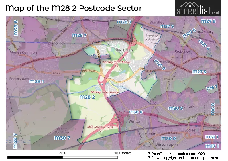
The M28 2 Postcode shares a border with M27 0 (Swinton), M27 9 (Swinton), M28 3 (Worsley), M30 8 (Eccles), M28 1 (Worsley), M28 7 (Worsley) and M30 7 (Eccles).
Map of the M28 2 Postcode Sector
Explore the M28 2 postcode sector by using our interactive map.
The sector is within the post town of MANCHESTER.
M28 2 is a postcode sector within the M28 postcode district which is within the M Manchester postcode area.
The Royal Mail delivery office for the M28 2 postal sector is the North West (m) Delivery Office.
The area of the M28 2 postcode sector is 3.00 square miles which is 7.76 square kilometres or 1,918.70 square acres.
The M28 2 postcode sector is crossed by the M62 motorway.
The M28 2 postcode sector is crossed by the M61 motorway.
The M28 2 postcode sector is crossed by the M602 motorway.
The M28 2 postcode sector is crossed by the M60 motorway.
Waterways within the M28 2 postcode sector include the Bridgewater Canal.
Your support helps keep this site running!
If you enjoy using this website, consider buying me a coffee to help cover hosting costs.


| M | 2 | 8 | - | 2 | X | X |
| M | 2 | 8 | Space | 2 | Letter | Letter |
Official List of Streets
Worsley (125 Streets)
Unofficial Streets or Alternative Spellings
Swinton
FAIRMOUNT ROAD INVAR ROAD RINGLOW PARK ROAD WARDLEY HALL ROAD WORSLEY ROADWorsley
BRIARFIELD ROAD GLENILLA AVENUE THE AVENUE ALPHABET BRIDGE BRIDGEWATER WAY BROAD OAK PARK DUKES HIDEAWAY GRANGE FARM BRIDGE MOORFIELD PORT SALFORD GREENWAY SANDERSON CLOSE ST MARKS CHURCH ROUNDABOUT TURNELL WAY TYLDESLEY LOOPLINE WILLOW STREET WORSLEY COURTHOUSE ROUNDABOUTEccles
WORSLEY ROADGlazebury
EAST LANCASHIRE ROADWeather Forecast for M28 2
Weather Forecast for Worsley
| Time Period | Icon | Description | Temperature | Rain Probability | Wind |
|---|---|---|---|---|---|
| 03:00 to 06:00 | Overcast | 5.0°C (feels like 1.0°C) | 10.00% | SSE 11 mph | |
| 06:00 to 09:00 | Overcast | 4.0°C (feels like 1.0°C) | 10.00% | SSE 11 mph | |
| 09:00 to 12:00 | Cloudy | 4.0°C (feels like 1.0°C) | 11.00% | SSE 9 mph | |
| 12:00 to 15:00 | Overcast | 6.0°C (feels like 3.0°C) | 9.00% | S 9 mph | |
| 15:00 to 18:00 | Overcast | 6.0°C (feels like 5.0°C) | 14.00% | S 7 mph | |
| 18:00 to 21:00 | Overcast | 6.0°C (feels like 4.0°C) | 12.00% | SSE 4 mph | |
| 21:00 to 00:00 | Overcast | 6.0°C (feels like 4.0°C) | 9.00% | S 4 mph |
| Time Period | Icon | Description | Temperature | Rain Probability | Wind |
|---|---|---|---|---|---|
| 00:00 to 03:00 | Overcast | 5.0°C (feels like 3.0°C) | 8.00% | S 4 mph | |
| 03:00 to 06:00 | Cloudy | 4.0°C (feels like 2.0°C) | 5.00% | S 4 mph | |
| 06:00 to 09:00 | Cloudy | 3.0°C (feels like 1.0°C) | 4.00% | SSE 7 mph | |
| 09:00 to 12:00 | Cloudy | 4.0°C (feels like 1.0°C) | 4.00% | SSE 7 mph | |
| 12:00 to 15:00 | Cloudy | 7.0°C (feels like 4.0°C) | 4.00% | S 9 mph | |
| 15:00 to 18:00 | Cloudy | 9.0°C (feels like 7.0°C) | 4.00% | S 9 mph | |
| 18:00 to 21:00 | Cloudy | 7.0°C (feels like 4.0°C) | 5.00% | S 11 mph | |
| 21:00 to 00:00 | Cloudy | 6.0°C (feels like 3.0°C) | 5.00% | S 11 mph |
| Time Period | Icon | Description | Temperature | Rain Probability | Wind |
|---|---|---|---|---|---|
| 00:00 to 03:00 | Cloudy | 6.0°C (feels like 3.0°C) | 5.00% | S 11 mph | |
| 03:00 to 06:00 | Overcast | 7.0°C (feels like 4.0°C) | 9.00% | S 11 mph | |
| 06:00 to 09:00 | Cloudy | 7.0°C (feels like 4.0°C) | 11.00% | S 11 mph | |
| 09:00 to 12:00 | Cloudy | 8.0°C (feels like 5.0°C) | 20.00% | S 11 mph | |
| 12:00 to 15:00 | Light rain | 9.0°C (feels like 6.0°C) | 54.00% | SSW 11 mph | |
| 15:00 to 18:00 | Light rain | 9.0°C (feels like 7.0°C) | 51.00% | SW 11 mph | |
| 18:00 to 21:00 | Clear night | 8.0°C (feels like 5.0°C) | 12.00% | SW 9 mph | |
| 21:00 to 00:00 | Clear night | 7.0°C (feels like 4.0°C) | 7.00% | WSW 9 mph |
| Time Period | Icon | Description | Temperature | Rain Probability | Wind |
|---|---|---|---|---|---|
| 00:00 to 03:00 | Clear night | 6.0°C (feels like 3.0°C) | 3.00% | W 9 mph | |
| 03:00 to 06:00 | Clear night | 5.0°C (feels like 2.0°C) | 2.00% | W 9 mph | |
| 06:00 to 09:00 | Clear night | 4.0°C (feels like 1.0°C) | 2.00% | WSW 7 mph | |
| 09:00 to 12:00 | Cloudy | 4.0°C (feels like 2.0°C) | 5.00% | SW 4 mph | |
| 12:00 to 15:00 | Cloudy | 7.0°C (feels like 5.0°C) | 4.00% | WSW 4 mph | |
| 15:00 to 18:00 | Sunny day | 8.0°C (feels like 6.0°C) | 1.00% | WSW 7 mph | |
| 18:00 to 21:00 | Clear night | 5.0°C (feels like 3.0°C) | 1.00% | SW 4 mph | |
| 21:00 to 00:00 | Clear night | 3.0°C (feels like 2.0°C) | 1.00% | SSE 4 mph |
Schools and Places of Education Within the M28 2 Postcode Sector
St Mark's CofE Primary School
Voluntary aided school
Aviary Road, Manchester, , M28 2WF
Head: Mrs Louise Mansfield
Ofsted Rating: Good
Inspection: 2019-01-30 (2195 days ago)
Website: Visit St Mark's CofE Primary School Website
Phone: 01617903423
Number of Pupils: 433
House Prices in the M28 2 Postcode Sector
| Type of Property | 2018 Average | 2018 Sales | 2017 Average | 2017 Sales | 2016 Average | 2016 Sales | 2015 Average | 2015 Sales |
|---|---|---|---|---|---|---|---|---|
| Detached | £591,980 | 36 | £544,940 | 31 | £484,095 | 31 | £460,667 | 32 |
| Semi-Detached | £344,011 | 41 | £359,946 | 65 | £307,119 | 43 | £304,414 | 56 |
| Terraced | £297,024 | 21 | £258,616 | 34 | £289,339 | 41 | £231,087 | 34 |
| Flats | £154,682 | 14 | £153,614 | 14 | £146,185 | 13 | £146,415 | 24 |
Important Postcodes M28 2 in the Postcode Sector
M28 2AA is the postcode for Royal Mail, North West Delivery Office, Shield Drive
M28 2LY is the postcode for Burrows House, Unit 10, Priestley Road
M28 2QW is the postcode for Beesley Green Community Centre, Beesley Green, Greenleach Lane
M28 2WF is the postcode for St. Marks C of E Primary School, Aviary Road, Worsley, St. Marks C of E Primary School, Aviary Road, and MODULAR BUILDING, St. Marks C of E Primary School, Aviary Road
M28 2WQ is the postcode for PREPARATORY DEPARTMENT, Bridgewater School, Worsley Road, SPORTS HALL, Bridgewater School, Worsley Road, and DRYWOOD HALL, SENIOR SCHOOL, MUSIC BLOCK AND KINDERGARTEN, Bridgewater School, Worsley Road
| The M28 2 Sector is within these Local Authorities |
|
|---|---|
| The M28 2 Sector is within these Counties |
|
| The M28 2 Sector is within these Water Company Areas |
|