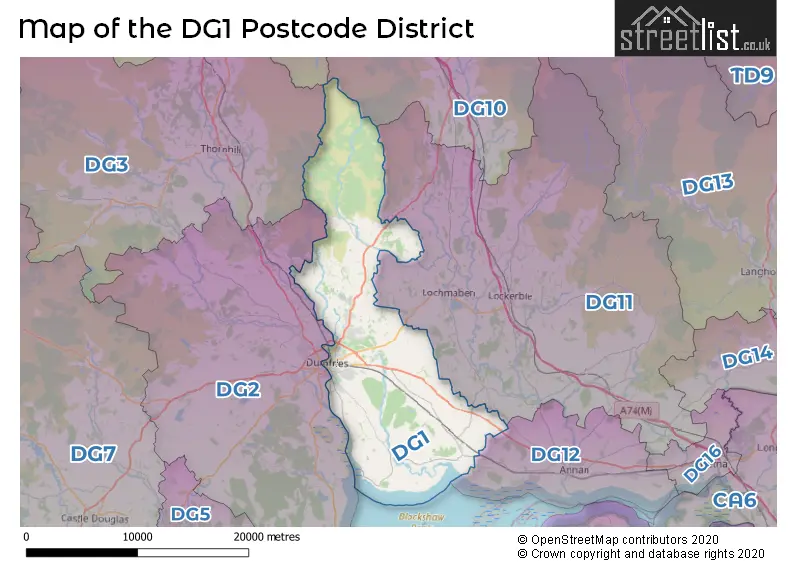
Map of the DG1 Postcode District
Explore the postcode district by using our interactive map.
Circles represent recorded crime; the larger the circle, the higher the crime rates.
Your support helps keep this site running!
If you enjoy using this website, consider buying me a coffee to help cover hosting costs.
Where is the DG1 District?
To give you an idea where the district is located we have created the following table showing nearby towns.
Nearest Towns to DG1
| Town | Distance (miles) | Direction |
|---|---|---|
| Lochmaben | 4.25 | ENE |
| Lockerbie | 7.37 | E |
| Annan | 13.71 | SE |
| Moffat | 16.26 | NNE |
| Dalbeattie | 16.35 | SW |
| Silloth | 17.40 | SSE |
| Castle Douglas | 19.18 | SW |
| Langholm | 21.68 | E |
| Longtown | 23.51 | ESE |
| Sanquhar | 23.74 | NW |
| New Galloway | 23.89 | W |
| Wigton | 24.54 | SE |
| Aspatria | 25.00 | SSE |
| Maryport | 27.05 | S |
| Kirkcudbright | 27.38 | SW |
| Carlisle | 28.24 | ESE |
| Gatehouse of Fleet | 30.05 | WSW |
| Cockermouth | 31.30 | SSE |
| Workington | 31.92 | S |
The post town for this district is DUMFRIES.
Postcode Information for District DG1 (Total Geographical Postcodes: 1027)
| Location | Post Town | Sector | Number of Postcodes |
|---|---|---|---|
| DUMFRIES | DUMFRIES | DG1 4 | 223 |
| DUMFRIES | DUMFRIES | DG1 3 | 164 |
| DUMFRIES | DUMFRIES | DG1 2 | 159 |
| DUMFRIES | DUMFRIES | DG1 1 | 131 |
| Heathhall | DUMFRIES | DG1 3 | 76 |
| Locharbriggs | DUMFRIES | DG1 1 | 52 |
| Collin | DUMFRIES | DG1 4 | 31 |
| Heathhall | DUMFRIES | DG1 1 | 20 |
| Parkgate | DUMFRIES | DG1 3 | 17 |
| Glencaple | DUMFRIES | DG1 4 | 17 |
| Torthorwald | DUMFRIES | DG1 3 | 16 |
| Amisfield | DUMFRIES | DG1 3 | 15 |
| Ruthwell | DUMFRIES | DG1 4 | 14 |
| Kirkton | DUMFRIES | DG1 1 | 12 |
| Mouswald | DUMFRIES | DG1 4 | 11 |
| Kirkmahoe | DUMFRIES | DG1 1 | 9 |
| Carrutherstown | DUMFRIES | DG1 4 | 9 |
| Kingholm Quay | DUMFRIES | DG1 4 | 9 |
| Ae | DUMFRIES | DG1 1 | 7 |
| Gasstown | DUMFRIES | DG1 3 | 6 |
| Clarencefield | DUMFRIES | DG1 4 | 5 |
| Bankend | DUMFRIES | DG1 4 | 5 |
| Caerlaverock | DUMFRIES | DG1 4 | 3 |
| Tinwald | DUMFRIES | DG1 3 | 3 |
| Duncow | DUMFRIES | DG1 1 | 3 |
| Brasswell | DUMFRIES | DG1 3 | 2 |
| Kelton | DUMFRIES | DG1 4 | 2 |
| Brasswell | DUMFRIES | DG1 4 | 1 |
| Shearington | DUMFRIES | DG1 4 | 1 |
| Racks | DUMFRIES | DG1 4 | 1 |
| Collin | DUMFRIES | DG1 3 | 1 |
| Georgetown | DUMFRIES | DG1 4 | 1 |
| Dalswinton | DUMFRIES | DG1 1 | 1 |
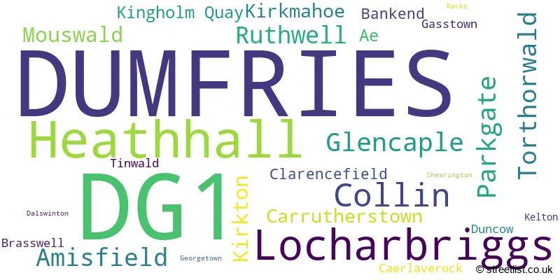
The primary settlement in the DG1 postcode district is Dumfries, located in the county of Dumfries in Scotland. Dumfries has the highest number of postcodes in the district. Other significant settlements in the district include Ae, Dalswinton, Duncow, Heathhall, Kirkmahoe, Kirkton, Locharbriggs, Amisfield, Brasswell, Collin, Gasstown, Parkgate, Tinwald, Torthorwald, Bankend, Caerlaverock, Carrutherstown, Clarencefield, Georgetown, Glencaple, Kelton, Kingholm Quay, Mouswald, Racks, Ruthwell, and Shearington.
When it comes to local government, postal geography often disregards political borders. However, this district intersects the following councils: the district mostly encompasses the Dumfries and Galloway area with a total of 1066 postal codes.
The largest settlement in the DG1 postal code is DUMFRIES followed by Heathhall, and Locharbriggs.
The postcode area has a boundary with Solway Firth.
The DG1 Postcode shares a border with DG11 (LOCKERBIE, Lochmaben, Ecclefechan), DG2 (DUMFRIES, Southerness, Auldgirth), DG12 (ANNAN, Eastriggs, Powfoot), DG10 (MOFFAT, Beattock, Wamphray) and DG3 (THORNHILL, Moniaive, Closeburn).


Stations in the Sector
Dumfries
CRS Code: DMF
Operator: SR
Line: Glasgow South Western Line
Company: ScotRail
Accessable Motorway Junctions
A74(M) J17
Average Driving Time from within the district: 17.98
Average Driving Distance: 13.35
Number of Postcodes that can access the Motorway Junction: 1049
A74(M) J21
Average Driving Time from within the district: 18.03
Average Driving Distance: 15.21
Number of Postcodes that can access the Motorway Junction: 38
A74(M) J18
Average Driving Time from within the district: 18.52
Average Driving Distance: 14.04
Number of Postcodes that can access the Motorway Junction: 1049
A74(M) J15
Average Driving Time from within the district: 19.51
Average Driving Distance: 15.24
Number of Postcodes that can access the Motorway Junction: 69
A74(M) J16
Average Driving Time from within the district: 20.64
Average Driving Distance: 15.68
Number of Postcodes that can access the Motorway Junction: 1011
A74(M) J19
Average Driving Time from within the district: 20.95
Average Driving Distance: 16.60
Number of Postcodes that can access the Motorway Junction: 1048
A74(M) J20
Average Driving Time from within the district: 22.11
Average Driving Distance: 17.96
Number of Postcodes that can access the Motorway Junction: 980
A74(M) J14
Average Driving Time from within the district: 34.63
Average Driving Distance: 29.68
Number of Postcodes that can access the Motorway Junction: 1
Weather Forecast for Dumfries
| Time Period | Icon | Description | Temperature | Rain Probability | Wind |
|---|---|---|---|---|---|
| 06:00 to 09:00 | Overcast | 4.0°C (feels like 3.0°C) | 15.00% | SSW 2 mph | |
| 09:00 to 12:00 | Drizzle | 4.0°C (feels like 3.0°C) | 26.00% | WSW 4 mph | |
| 12:00 to 15:00 | Overcast | 6.0°C (feels like 4.0°C) | 14.00% | SSW 4 mph | |
| 15:00 to 18:00 | Cloudy | 6.0°C (feels like 5.0°C) | 9.00% | SSW 4 mph | |
| 18:00 to 21:00 | Cloudy | 4.0°C (feels like 3.0°C) | 11.00% | S 4 mph | |
| 21:00 to 00:00 | Overcast | 4.0°C (feels like 3.0°C) | 13.00% | SE 4 mph |
| Time Period | Icon | Description | Temperature | Rain Probability | Wind |
|---|---|---|---|---|---|
| 00:00 to 03:00 | Cloudy | 4.0°C (feels like 2.0°C) | 11.00% | SE 2 mph | |
| 03:00 to 06:00 | Overcast | 3.0°C (feels like 2.0°C) | 11.00% | SE 4 mph | |
| 06:00 to 09:00 | Overcast | 3.0°C (feels like 2.0°C) | 11.00% | ESE 4 mph | |
| 09:00 to 12:00 | Overcast | 3.0°C (feels like 2.0°C) | 10.00% | ESE 4 mph | |
| 12:00 to 15:00 | Overcast | 4.0°C (feels like 3.0°C) | 12.00% | ENE 4 mph | |
| 15:00 to 18:00 | Cloudy | 5.0°C (feels like 3.0°C) | 9.00% | ENE 4 mph | |
| 18:00 to 21:00 | Cloudy | 4.0°C (feels like 2.0°C) | 6.00% | E 4 mph | |
| 21:00 to 00:00 | Cloudy | 3.0°C (feels like 1.0°C) | 8.00% | ESE 4 mph |
| Time Period | Icon | Description | Temperature | Rain Probability | Wind |
|---|---|---|---|---|---|
| 00:00 to 03:00 | Cloudy | 3.0°C (feels like 1.0°C) | 11.00% | ESE 4 mph | |
| 03:00 to 06:00 | Cloudy | 3.0°C (feels like 1.0°C) | 14.00% | NNW 4 mph | |
| 06:00 to 09:00 | Overcast | 3.0°C (feels like 1.0°C) | 19.00% | ESE 4 mph | |
| 09:00 to 12:00 | Overcast | 3.0°C (feels like 1.0°C) | 16.00% | SW 7 mph | |
| 12:00 to 15:00 | Cloudy | 5.0°C (feels like 3.0°C) | 12.00% | SW 7 mph | |
| 15:00 to 18:00 | Cloudy | 5.0°C (feels like 3.0°C) | 12.00% | SW 7 mph | |
| 18:00 to 21:00 | Overcast | 4.0°C (feels like 1.0°C) | 13.00% | SW 7 mph | |
| 21:00 to 00:00 | Cloudy | 3.0°C (feels like 1.0°C) | 10.00% | S 4 mph |
| Postal Sector | Delivery Office |
|---|---|
| DG1 1 | Dumfries Delivery Office |
| DG1 2 | Dumfries Delivery Office |
| DG1 3 | Dumfries Delivery Office |
| DG1 4 | Dumfries Delivery Office |
| D | G | 1 | - | X | X | X |
| D | G | 1 | Space | Numeric | Letter | Letter |
Street List for the DG1 District
Current Monthly Rental Prices
| # Bedrooms | Min Price | Max Price | Avg Price |
|---|---|---|---|
| 1 | £390 | £390 | £390 |
| 2 | £630 | £630 | £630 |
Current House Prices
| # Bedrooms | Min Price | Max Price | Avg Price |
|---|---|---|---|
| £90,000 | £90,000 | £90,000 | |
| 1 | £40,000 | £119,950 | £69,488 |
| 2 | £65,000 | £260,000 | £123,500 |
| 3 | £90,000 | £320,000 | £177,498 |
| 4 | £140,000 | £530,000 | £346,111 |
| 5 | £220,000 | £1,149,999 | £497,500 |
| 6 | £445,000 | £1,975,000 | £1,210,000 |
| 7 | £150,000 | £150,000 | £150,000 |
Estate Agents
| Logo | Name | Brand Name | Address | Contact Number |
|---|---|---|---|---|
 | Scotland | Yopa | Meridian House Wheatfield Way Hinckley LE10 1YG | 0161 524 0574 |
 | Dumfries | YOUR MOVE | 2 Queensberry Street, Dumfries, DG1 1EX | 01387 213713 |
 | Covering Nationwide | The Agency UK | Covering Nationwide | 020 3909 1509 |
 | Carlisle | Hunters | 56 Warwick Road, Carlisle, Cumbria, CA1 1DR | 01228 582073 |
 | London | OpenRent | 39 Great Windmill Street London W1D 7LX | 020 3322 3265 |
