YO60 7RW is a postal code used within the United Kingdom for delivering mail.
Postcodes are made up of two parts. The part before the space (YO60) is called the outward code. The part after the space (7RW) is called the inward code. The letters C, I, K, M, O and V are not allowed in the inward code. In addition to the inward and outward code, the postcode can be broken up into four parts:
- Postal Area. In our case YO which means York.
- Postal District. In our case YO60.
- Postal Sector. In our case YO60 7.
- Postcode Unit. The last two letters. In our case RW.
The regional mail center for the post area YO is the Yorkshire Distribution Centre, which is located at Silkstone House, Express Way, Wakefield Europort, NORMANTON, WF6 2XX.
The final port of call for any post addressed to the YO60 7RW postcode is the local delivery office (DO) which is . Here the post will be sorted ready for delivery.
Did you know? According to the 2021 Census, the YO60 7RW postcode is home to a bustling 23 residents!
YO60 7RW is within the village of Flaxton.
The YO60 7RW postcode area is composed of 100% residential properties, 0% commercial properties, and 0% public properties.
Interactive Mapping Showing UPRNs within the boundary of the postcode
Use the search box to search for other postcodes or places.
Your support helps keep this site running!
If you enjoy using this website, consider buying me a coffee to help cover hosting costs.
Moving to YO60 7RW?
I can help you uncover potential pitfalls and provide key questions to ask about your new property. With decades of experience as a Local Land Charges Manager, I offer confidential insights to make your move informed and stress-free.
This service is free, but you may make wish to make an optional donation to support it. Please include the property name and address in your request as well as anything you wish to focus on.
Contact Me| Property Type | Percentage |
|---|---|
| Residential | 100% |
| Commercial | 0% |
| Public | 0% |
Map Coordinates
| Latitude | 54.0515604947 |
|---|---|
| Longitude | -0.963509921853 |
Retail and Shopping near YO60 7RW
Street
Town
Locality
Distance (Miles)
Central Postcode
Directions on Google Maps
THE SQUARE
YORK
STAMFORD BRIDGE
4.62
YO41 1AG
View on Google Maps
THE VILLAGE
YORK
HAXBY
5.10
YO32 3HS
View on Google Maps
NORTH MOOR ROAD
YORK
HUNTINGTON
5.33
YO32 9QN
View on Google Maps
MONKS CROSS DRIVE
YORK
HUNTINGTON
5.46
YO32 9GX
View on Google Maps
Nearest Town
Distance (Miles)
Direction
Bearing
Haxby
5.05
WSW
240.91
York
7.89
SW
218.32
Malton
8.91
NE
49.59
Easingwold
10.52
WNW
296.93
Pocklington
11.25
SE
137.74
Helmsley
14.06
NNW
343.69
Kirkbymoorside
15.13
N
4.95
Pickering
15.41
NNE
28.98
Boroughbridge
17.82
W
279.73
Selby
19.01
SSW
193.21
Thirsk
19.85
NW
309.31
Howden
21.50
S
169.51
Driffield
21.55
E
98.27
Weather Forecast
Weather Forecast for Castle Howard
Time Period Icon Description Temperature Rain Probability Wind 12:00 to 15:00 
Fog 6.0°C (feels like 5.0°C) 18.00% WSW 2 mph 15:00 to 18:00 
Mist 7.0°C (feels like 6.0°C) 17.00% SSW 4 mph 18:00 to 21:00 Fog 7.0°C (feels like 5.0°C) 17.00% SSW 4 mph 21:00 to 00:00 Fog 6.0°C (feels like 5.0°C) 18.00% SW 4 mph
Time Period Icon Description Temperature Rain Probability Wind 00:00 to 03:00 Fog 6.0°C (feels like 4.0°C) 19.00% SSW 4 mph 03:00 to 06:00 Fog 6.0°C (feels like 4.0°C) 18.00% SSW 4 mph 06:00 to 09:00 Fog 6.0°C (feels like 4.0°C) 18.00% SSW 4 mph 09:00 to 12:00 Mist 6.0°C (feels like 4.0°C) 17.00% SSW 4 mph 12:00 to 15:00 
Cloudy 8.0°C (feels like 6.0°C) 10.00% SW 7 mph 15:00 to 18:00 
Overcast 8.0°C (feels like 6.0°C) 9.00% SW 7 mph 18:00 to 21:00 Cloudy 7.0°C (feels like 5.0°C) 4.00% SW 7 mph 21:00 to 00:00 Cloudy 7.0°C (feels like 5.0°C) 6.00% SW 7 mph
Time Period Icon Description Temperature Rain Probability Wind 00:00 to 03:00 Overcast 7.0°C (feels like 5.0°C) 11.00% SW 7 mph 03:00 to 06:00 
Partly cloudy (night) 7.0°C (feels like 4.0°C) 2.00% SW 9 mph 06:00 to 09:00 Cloudy 6.0°C (feels like 3.0°C) 4.00% WSW 9 mph 09:00 to 12:00 Cloudy 7.0°C (feels like 3.0°C) 4.00% WSW 11 mph 12:00 to 15:00 Cloudy 9.0°C (feels like 5.0°C) 4.00% WSW 13 mph 15:00 to 18:00 Overcast 9.0°C (feels like 5.0°C) 7.00% WSW 13 mph 18:00 to 21:00 Overcast 8.0°C (feels like 5.0°C) 7.00% WSW 13 mph 21:00 to 00:00 Overcast 8.0°C (feels like 5.0°C) 9.00% WSW 13 mph
Time Period Icon Description Temperature Rain Probability Wind 00:00 to 03:00 Overcast 8.0°C (feels like 5.0°C) 8.00% WSW 13 mph 03:00 to 06:00 Cloudy 8.0°C (feels like 5.0°C) 6.00% WSW 13 mph 06:00 to 09:00 Cloudy 8.0°C (feels like 5.0°C) 7.00% SW 13 mph 09:00 to 12:00 Cloudy 8.0°C (feels like 5.0°C) 6.00% SW 16 mph 12:00 to 15:00 Cloudy 10.0°C (feels like 6.0°C) 5.00% SW 16 mph 15:00 to 18:00 Cloudy 10.0°C (feels like 6.0°C) 8.00% SW 18 mph 18:00 to 21:00 Cloudy 9.0°C (feels like 6.0°C) 8.00% SW 16 mph 21:00 to 00:00 Cloudy 9.0°C (feels like 6.0°C) 10.00% SW 16 mph
Time Period Icon Description Temperature Rain Probability Wind 00:00 to 03:00 Cloudy 9.0°C (feels like 6.0°C) 12.00% SW 16 mph 03:00 to 06:00 Cloudy 9.0°C (feels like 5.0°C) 16.00% SW 16 mph 06:00 to 09:00 Cloudy 8.0°C (feels like 5.0°C) 17.00% WSW 16 mph 09:00 to 12:00 Cloudy 8.0°C (feels like 5.0°C) 18.00% WSW 16 mph 12:00 to 15:00 Cloudy 8.0°C (feels like 5.0°C) 20.00% W 16 mph 15:00 to 18:00 Cloudy 7.0°C (feels like 4.0°C) 21.00% WNW 13 mph 18:00 to 21:00 Cloudy 6.0°C (feels like 2.0°C) 16.00% WNW 11 mph 21:00 to 00:00 Cloudy 5.0°C (feels like 1.0°C) 17.00% WNW 11 mph
What are the Broadband Speeds like?
Download Speeds

Average Mbps 43.700 Median Mbps 48.800 Maximum Mbps 58.550
YO60 7RW has an average download speed of 43.7 Megabits per second (Mbps).
1,249 other postcode units have the same broadband speed.
19% of postcodes (224,432) have slower broadband speeds.
81% of postcodes (958,960) have faster broadband speeds.
Upload Speeds

Average Mbps 10.700 Median Mbps 10.000 Maximum Mbps 18.340
YO60 7RW has an average upload speed of 10.7 Megabits per second (Mbps).
6,810 other postcode units have the same upload speed.
28% of postcodes (326,473) have slower upload speeds.
72% of postcodes (851,358) have faster upload speeds.
Schools within a five minute Drive
England Primary Schools
Foston Church of England Voluntary Controlled Primary School
Address: Foston Church of England Voluntary Controlled Primary School, Main Street, Foston, York, North Yorkshire, YO60 7QB
Distance: 1.73 miles
Contact: 01653618265
Nearest Dentists
HOWARDIAN DENTAL
Address: 11 ALAN FARNABY WAY, THE INDUSTRIAL ESTATE, SHERIFF HUTTON, YORK, YO60 6PG
Distance: 3.15 miles
Contact: http: HTTP://HOWARDIANDENTAL.CO.UK
PURE DENTAL YORK STRENSALL
Address: 34 BARLEY RISE, STRENSALL, YORK, YO32 5AA
Distance: 3.55 miles
Contact: :
YORK DENTAL CENTRE
Address: STRENSALL, YORK, NORTH YORKSHIRE, YO32 5SW
Distance: 3.61 miles
Contact: :
DENTAL SURGERY
Address: 27 VIKING ROAD, STAMFORD BRIDGE, YORK, NORTH YORKSHIRE, YO41 1BS
Distance: 4.70 miles
Contact: :
HAXBY FAMILY DENTAL
Address: 9 THE VILLAGE, HAXBY, YORK, NORTH YORKSHIRE, YO32 3HS
Distance: 5.07 miles
Contact: :
W S INNESS DENTAL SURGERY
Address: 70 THE VILLAGE, HAXBY, YORK, NORTH YORKSHIRE, YO32 2HX
Distance: 5.19 miles
Contact: :
Nearest Chemists
BOOTS
Address: 25B THE VILLAGE, STRENSALL, YORK, NORTH YORKSHIRE, YO32 5XR
Distance: 2.98 miles
Contact: tel: 01904 492497
STAMFORD BRIDGE PHARMACY
Address: 2E THE SQUARE, STAMFORD BRIDGE, YORK, NORTH YORKSHIRE, YO41 1AF
Distance: 4.60 miles
Contact: tel: 01759 372886
BOOTS
Address: 68 THE VILLAGE, HAXBY, YORK, NORTH YORKSHIRE, YO32 2HX
Distance: 5.19 miles
Contact: tel: 01904 768911
CITYWIDE HEALTH-HAXBY PHARMACY
Address: 6 WYRE COURT, THE VILLAGE, HAXBY, YORK, YO32 2ZB
Distance: 5.25 miles
Contact: tel: 01904 928100
CITYWIDE-PARKERS & HUNTINGTON PHARMACY
Address: 61 NORTH MOOR ROAD, HUNTINGTON, YORK, YO32 9QN
Distance: 5.34 miles
Contact: tel: 01904 762566
BOOTS
Address: UNIT 7, MONKS CROSS SHOPPING PARK, MONKS CROSS DRIVE, HUNTINGTON, YORK, NORTH YORKSHIRE, YO32 9GX
Distance: 5.49 miles
Contact: tel: 01904 656360
Nearest Opticians
HAXBY OPTICIANS
Address: 6 RYEDALE COURT, SHOPPING CENTRE, HAXBY, YORK, NORTH YORKSHIRE, YO32 3SA
Distance: 5.09 miles
Contact: :
4689 YORK
Address: ASDA STORES LTD, JOCKEY LANE, HUNTINGTON, YORK, NORTH YORKSHIRE, YO32 9LF
Distance: 5.55 miles
Contact: :
M&S OPTICIANS - YORK
Address: UNIT A, VANGARDE WAY, HUNTINGTON, YORK, YO32 9AE
Distance: 5.89 miles
Contact: :
VANGARDE SPECSAVERS LIMITED
Address: KIOSK 1, VANGARDE WAY, HUNTINGTON, YORK, YO32 9AE
Distance: 5.89 miles
Contact: :
YORKSHIRE EYE SPECIALISTS - NUFFIELD
Address: NUFFIELD HEALTH YORK HOSPITAL, HAXBY ROAD, YORK, YO31 8TA
Distance: 6.95 miles
Contact: :
BOOTS OPTICIANS (CLIFTON MOOR, YORK)
Address: 7-8 STIRLING ROAD, CLIFTON MOOR CENTRE, YORK, NORTH YORKSHIRE, YO30 4XZ
Distance: 6.95 miles
Contact: :
Nearest GP Surgeries
MY HEALTH GROUP
Address: SOUTHFIELDS ROAD, STRENSALL, YORK, NORTH YORKSHIRE, YO32 5UA
Distance: 3.01 miles
Contact: tel: 01904 490532
STOCKTON ON FOREST
Address: THE SURGERY, 36 THE VILLAGE, STOCKTON ON FOREST, YORK, NORTH YORKSHIRE, YO32 9UQ
Distance: 4.36 miles
Contact: :
MYHEALTH - STAMFORD BRIDGE
Address: STAMFORD BRIDGE MEDICAL CENTRE, VIKING ROAD, STAMFORD BRIDGE, YORK, NORTH YORKSHIRE, YO41 1BR
Distance: 4.68 miles
Contact: :
HUNTINGTON
Address: THE SURGERY, 1 NORTH LANE, HUNTINGTON, YORK, NORTH YORKSHIRE, YO32 9RU
Distance: 5.21 miles
Contact: :
HAXBY GROUP PRACTICE
Address: HAXBY/WIGGINTON HLTH CTR., 2 THE VILLAGE, WIGGINTON, YORK, NORTH YORKSHIRE, YO32 2LL
Distance: 5.30 miles
Contact: tel: 01904 928008
HAXBY HEALTH CENTRE - COVID LOCAL VACCINATION SERVICE 2
Address: HAXBY & WIGGINTON HEALTH CENTRE, 2 THE VILLAGE, WIGGINTON, YORK, YO32 2LL
Distance: 5.30 miles
Contact: :
Transport Links
Train Stations
Malton
Address: Malton station, Railway Street, Malton, North Yorkshire, YO17 9RD
Postcode: YO17 9RD
Line: York to Scarborough line
Company: TransPennine Express
Time: within fifteen minutes drive
Distance: 8.74 miles
Poppleton
Address: Poppleton station, Station Road, Upper Poppleton, North Yorkshire, YO26 6PZ
Postcode: YO26 6PZ
Line: Harrogate line
Company: Northern
Time: within fifteen minutes drive
Distance: 9.15 miles
Distances are as the crow flies.
Motorway Junctions
A1(M) J47Distance: 21.25 milesDriving Time: 26.36 minutesA1(M) J46Distance: 22.61 milesDriving Time: 28.92 minutesA1(M) J48Distance: 26.20 milesDriving Time: 31.16 minutesA1(M) J45Distance: 28.47 milesDriving Time: 29.53 minutesA1(M) J49Distance: 32.41 milesDriving Time: 38.14 minutes Distances represent the quickest route by car.
Who are my Elected Representatives?
Westminster Constituency Thirsk and Malton Member or Parliament 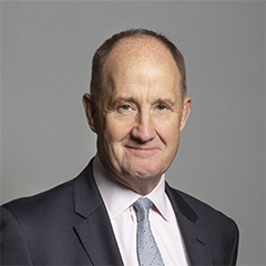
Kevin Hollinrake Contact Details Contact Kevin Hollinrake Political Party Conservative
Where can I find out where the nearest Library is?
Libraries are the responsibility of North Yorkshire County Council
Visit the link for more information. Please note that some councils outsource library services to private companies and community groups ran by volunteers.
Libraries | North Yorkshire County Council
House Sales
Yearly House Sales
Year High Low Average Sales 2023 £725,000 £725,000 £725,000 1
Contains HM Land Registry data © Crown copyright and database right 2024. This data is licensed under the Open Government Licence v3.0.
What Popular Supermarkets are near?
Popular Supermarkets near YO60 7RW Supermarket Distance Directions Asda, Jockey Lane, Huntington, YORK, YO32 9LF 8.91 miles Directions to Asda Sainsburys, Jockey Lane, Huntington, YORK, YO32 9LG 9.11 miles Directions to Sainsburys Aldi, Kathryn Avenue, Huntington, YORK, YO32 9JS 9.32 miles Directions to Aldi Lidl, James Street, YORK, YO10 3WW 12.60 miles Directions to Lidl
What Popular Restaurants are near?
Burger King Restaurants near YO60 7RW Burger King Distance Directions Clifton Moor Retail Park, York, YO30 4XZ 7.11 miles Directions to Clifton Moor Retail Park York Railway Station, Station Road, York, YO24 1AB 8.32 miles Directions to York Railway Station, Station Road York East, LS24 8EG 13.90 miles Directions to York East Junction 46, A1(m) Kirk Deighton, Kirk Deighton, LS22 5GT 17.97 miles Directions to Junction 46, A1(m) Kirk Deighton
Mcdonald's Restaurants near YO60 7RW Mcdonald's Distance Directions McDonald's, Monks Cross Drive, Huntington, YORK, YO32 9GW 5.54 miles Directions to McDonald's, Monks Cross Drive, Huntington, YORK, YO32 9GW McDonald's, Hurricane Way, Clifton Moor Centre, YORK, YO30 4XU 7.27 miles Directions to McDonald's, Hurricane Way, Clifton Moor Centre, YORK, YO30 4XU McDonald's, Blake Street, YORK, YO1 8QG 7.97 miles Directions to McDonald's, Blake Street, YORK, YO1 8QG McDonald's, Boroughbridge Road, Upper Poppleton, YORK, YO26 6QD 9.11 miles Directions to McDonald's, Boroughbridge Road, Upper Poppleton, YORK, YO26 6QD
KFC Restaurants near YO60 7RW Restaurant Distance Directions KFC, Stirling Road, Clifton Moor Centre, YORK, YO30 4WZ 6.77 miles Directions to KFC Clifton Moor - Stirling Road KFC, Pocklington Airfield Industrial Estate, Pocklington, YORK, YO42 1NR 11.02 miles Directions to KFC Pocklington - York Road KFC, Kirk Deighton, WETHERBY, LS22 5GT 17.95 miles Directions to KFC Wetherby - A1M Services KFC, Colorado Way, CASTLEFORD, WF10 4TA 28.14 miles Directions to KFC Glasshoughton - Colorado Way KFC, Cornmarket, PONTEFRACT, WF8 1BJ 28.61 miles Directions to KFC Pontefract - Cornmarket
| Street | Town | Locality | Distance (Miles) | Central Postcode | Directions on Google Maps |
|---|---|---|---|---|---|
| THE SQUARE | YORK | STAMFORD BRIDGE | 4.62 | YO41 1AG | View on Google Maps |
| THE VILLAGE | YORK | HAXBY | 5.10 | YO32 3HS | View on Google Maps |
| NORTH MOOR ROAD | YORK | HUNTINGTON | 5.33 | YO32 9QN | View on Google Maps |
| MONKS CROSS DRIVE | YORK | HUNTINGTON | 5.46 | YO32 9GX | View on Google Maps |
| Nearest Town | Distance (Miles) | Direction | Bearing |
|---|---|---|---|
| Haxby | 5.05 | WSW | 240.91 |
| York | 7.89 | SW | 218.32 |
| Malton | 8.91 | NE | 49.59 |
| Easingwold | 10.52 | WNW | 296.93 |
| Pocklington | 11.25 | SE | 137.74 |
| Helmsley | 14.06 | NNW | 343.69 |
| Kirkbymoorside | 15.13 | N | 4.95 |
| Pickering | 15.41 | NNE | 28.98 |
| Boroughbridge | 17.82 | W | 279.73 |
| Selby | 19.01 | SSW | 193.21 |
| Thirsk | 19.85 | NW | 309.31 |
| Howden | 21.50 | S | 169.51 |
| Driffield | 21.55 | E | 98.27 |
Weather Forecast
Weather Forecast for Castle Howard
| Time Period | Icon | Description | Temperature | Rain Probability | Wind |
|---|---|---|---|---|---|
| 12:00 to 15:00 | Fog | 6.0°C (feels like 5.0°C) | 18.00% | WSW 2 mph | |
| 15:00 to 18:00 | Mist | 7.0°C (feels like 6.0°C) | 17.00% | SSW 4 mph | |
| 18:00 to 21:00 | Fog | 7.0°C (feels like 5.0°C) | 17.00% | SSW 4 mph | |
| 21:00 to 00:00 | Fog | 6.0°C (feels like 5.0°C) | 18.00% | SW 4 mph |
| Time Period | Icon | Description | Temperature | Rain Probability | Wind |
|---|---|---|---|---|---|
| 00:00 to 03:00 | Fog | 6.0°C (feels like 4.0°C) | 19.00% | SSW 4 mph | |
| 03:00 to 06:00 | Fog | 6.0°C (feels like 4.0°C) | 18.00% | SSW 4 mph | |
| 06:00 to 09:00 | Fog | 6.0°C (feels like 4.0°C) | 18.00% | SSW 4 mph | |
| 09:00 to 12:00 | Mist | 6.0°C (feels like 4.0°C) | 17.00% | SSW 4 mph | |
| 12:00 to 15:00 | Cloudy | 8.0°C (feels like 6.0°C) | 10.00% | SW 7 mph | |
| 15:00 to 18:00 | Overcast | 8.0°C (feels like 6.0°C) | 9.00% | SW 7 mph | |
| 18:00 to 21:00 | Cloudy | 7.0°C (feels like 5.0°C) | 4.00% | SW 7 mph | |
| 21:00 to 00:00 | Cloudy | 7.0°C (feels like 5.0°C) | 6.00% | SW 7 mph |
| Time Period | Icon | Description | Temperature | Rain Probability | Wind |
|---|---|---|---|---|---|
| 00:00 to 03:00 | Overcast | 7.0°C (feels like 5.0°C) | 11.00% | SW 7 mph | |
| 03:00 to 06:00 | Partly cloudy (night) | 7.0°C (feels like 4.0°C) | 2.00% | SW 9 mph | |
| 06:00 to 09:00 | Cloudy | 6.0°C (feels like 3.0°C) | 4.00% | WSW 9 mph | |
| 09:00 to 12:00 | Cloudy | 7.0°C (feels like 3.0°C) | 4.00% | WSW 11 mph | |
| 12:00 to 15:00 | Cloudy | 9.0°C (feels like 5.0°C) | 4.00% | WSW 13 mph | |
| 15:00 to 18:00 | Overcast | 9.0°C (feels like 5.0°C) | 7.00% | WSW 13 mph | |
| 18:00 to 21:00 | Overcast | 8.0°C (feels like 5.0°C) | 7.00% | WSW 13 mph | |
| 21:00 to 00:00 | Overcast | 8.0°C (feels like 5.0°C) | 9.00% | WSW 13 mph |
| Time Period | Icon | Description | Temperature | Rain Probability | Wind |
|---|---|---|---|---|---|
| 00:00 to 03:00 | Overcast | 8.0°C (feels like 5.0°C) | 8.00% | WSW 13 mph | |
| 03:00 to 06:00 | Cloudy | 8.0°C (feels like 5.0°C) | 6.00% | WSW 13 mph | |
| 06:00 to 09:00 | Cloudy | 8.0°C (feels like 5.0°C) | 7.00% | SW 13 mph | |
| 09:00 to 12:00 | Cloudy | 8.0°C (feels like 5.0°C) | 6.00% | SW 16 mph | |
| 12:00 to 15:00 | Cloudy | 10.0°C (feels like 6.0°C) | 5.00% | SW 16 mph | |
| 15:00 to 18:00 | Cloudy | 10.0°C (feels like 6.0°C) | 8.00% | SW 18 mph | |
| 18:00 to 21:00 | Cloudy | 9.0°C (feels like 6.0°C) | 8.00% | SW 16 mph | |
| 21:00 to 00:00 | Cloudy | 9.0°C (feels like 6.0°C) | 10.00% | SW 16 mph |
| Time Period | Icon | Description | Temperature | Rain Probability | Wind |
|---|---|---|---|---|---|
| 00:00 to 03:00 | Cloudy | 9.0°C (feels like 6.0°C) | 12.00% | SW 16 mph | |
| 03:00 to 06:00 | Cloudy | 9.0°C (feels like 5.0°C) | 16.00% | SW 16 mph | |
| 06:00 to 09:00 | Cloudy | 8.0°C (feels like 5.0°C) | 17.00% | WSW 16 mph | |
| 09:00 to 12:00 | Cloudy | 8.0°C (feels like 5.0°C) | 18.00% | WSW 16 mph | |
| 12:00 to 15:00 | Cloudy | 8.0°C (feels like 5.0°C) | 20.00% | W 16 mph | |
| 15:00 to 18:00 | Cloudy | 7.0°C (feels like 4.0°C) | 21.00% | WNW 13 mph | |
| 18:00 to 21:00 | Cloudy | 6.0°C (feels like 2.0°C) | 16.00% | WNW 11 mph | |
| 21:00 to 00:00 | Cloudy | 5.0°C (feels like 1.0°C) | 17.00% | WNW 11 mph |
What are the Broadband Speeds like?
Download Speeds
| Average Mbps | 43.700 |
|---|---|
| Median Mbps | 48.800 |
| Maximum Mbps | 58.550 |
YO60 7RW has an average download speed of 43.7 Megabits per second (Mbps).
1,249 other postcode units have the same broadband speed.
19% of postcodes (224,432) have slower broadband speeds.
81% of postcodes (958,960) have faster broadband speeds.
Upload Speeds
| Average Mbps | 10.700 |
|---|---|
| Median Mbps | 10.000 |
| Maximum Mbps | 18.340 |
YO60 7RW has an average upload speed of 10.7 Megabits per second (Mbps).
6,810 other postcode units have the same upload speed.
28% of postcodes (326,473) have slower upload speeds.
72% of postcodes (851,358) have faster upload speeds.
Schools within a five minute Drive
England Primary Schools
Foston Church of England Voluntary Controlled Primary School
Address: Foston Church of England Voluntary Controlled Primary School, Main Street, Foston, York, North Yorkshire, YO60 7QB
Distance: 1.73 miles
Contact: 01653618265
Nearest Dentists
HOWARDIAN DENTAL
Address: 11 ALAN FARNABY WAY, THE INDUSTRIAL ESTATE, SHERIFF HUTTON, YORK, YO60 6PG
Distance: 3.15 miles
Contact: http: HTTP://HOWARDIANDENTAL.CO.UK
PURE DENTAL YORK STRENSALL
Address: 34 BARLEY RISE, STRENSALL, YORK, YO32 5AA
Distance: 3.55 miles
Contact: :
YORK DENTAL CENTRE
Address: STRENSALL, YORK, NORTH YORKSHIRE, YO32 5SW
Distance: 3.61 miles
Contact: :
DENTAL SURGERY
Address: 27 VIKING ROAD, STAMFORD BRIDGE, YORK, NORTH YORKSHIRE, YO41 1BS
Distance: 4.70 miles
Contact: :
HAXBY FAMILY DENTAL
Address: 9 THE VILLAGE, HAXBY, YORK, NORTH YORKSHIRE, YO32 3HS
Distance: 5.07 miles
Contact: :
W S INNESS DENTAL SURGERY
Address: 70 THE VILLAGE, HAXBY, YORK, NORTH YORKSHIRE, YO32 2HX
Distance: 5.19 miles
Contact: :
Nearest Chemists
BOOTS
Address: 25B THE VILLAGE, STRENSALL, YORK, NORTH YORKSHIRE, YO32 5XR
Distance: 2.98 miles
Contact: tel: 01904 492497
STAMFORD BRIDGE PHARMACY
Address: 2E THE SQUARE, STAMFORD BRIDGE, YORK, NORTH YORKSHIRE, YO41 1AF
Distance: 4.60 miles
Contact: tel: 01759 372886
BOOTS
Address: 68 THE VILLAGE, HAXBY, YORK, NORTH YORKSHIRE, YO32 2HX
Distance: 5.19 miles
Contact: tel: 01904 768911
CITYWIDE HEALTH-HAXBY PHARMACY
Address: 6 WYRE COURT, THE VILLAGE, HAXBY, YORK, YO32 2ZB
Distance: 5.25 miles
Contact: tel: 01904 928100
CITYWIDE-PARKERS & HUNTINGTON PHARMACY
Address: 61 NORTH MOOR ROAD, HUNTINGTON, YORK, YO32 9QN
Distance: 5.34 miles
Contact: tel: 01904 762566
BOOTS
Address: UNIT 7, MONKS CROSS SHOPPING PARK, MONKS CROSS DRIVE, HUNTINGTON, YORK, NORTH YORKSHIRE, YO32 9GX
Distance: 5.49 miles
Contact: tel: 01904 656360
Nearest Opticians
HAXBY OPTICIANS
Address: 6 RYEDALE COURT, SHOPPING CENTRE, HAXBY, YORK, NORTH YORKSHIRE, YO32 3SA
Distance: 5.09 miles
Contact: :
4689 YORK
Address: ASDA STORES LTD, JOCKEY LANE, HUNTINGTON, YORK, NORTH YORKSHIRE, YO32 9LF
Distance: 5.55 miles
Contact: :
M&S OPTICIANS - YORK
Address: UNIT A, VANGARDE WAY, HUNTINGTON, YORK, YO32 9AE
Distance: 5.89 miles
Contact: :
VANGARDE SPECSAVERS LIMITED
Address: KIOSK 1, VANGARDE WAY, HUNTINGTON, YORK, YO32 9AE
Distance: 5.89 miles
Contact: :
YORKSHIRE EYE SPECIALISTS - NUFFIELD
Address: NUFFIELD HEALTH YORK HOSPITAL, HAXBY ROAD, YORK, YO31 8TA
Distance: 6.95 miles
Contact: :
BOOTS OPTICIANS (CLIFTON MOOR, YORK)
Address: 7-8 STIRLING ROAD, CLIFTON MOOR CENTRE, YORK, NORTH YORKSHIRE, YO30 4XZ
Distance: 6.95 miles
Contact: :
Nearest GP Surgeries
MY HEALTH GROUP
Address: SOUTHFIELDS ROAD, STRENSALL, YORK, NORTH YORKSHIRE, YO32 5UA
Distance: 3.01 miles
Contact: tel: 01904 490532
STOCKTON ON FOREST
Address: THE SURGERY, 36 THE VILLAGE, STOCKTON ON FOREST, YORK, NORTH YORKSHIRE, YO32 9UQ
Distance: 4.36 miles
Contact: :
MYHEALTH - STAMFORD BRIDGE
Address: STAMFORD BRIDGE MEDICAL CENTRE, VIKING ROAD, STAMFORD BRIDGE, YORK, NORTH YORKSHIRE, YO41 1BR
Distance: 4.68 miles
Contact: :
HUNTINGTON
Address: THE SURGERY, 1 NORTH LANE, HUNTINGTON, YORK, NORTH YORKSHIRE, YO32 9RU
Distance: 5.21 miles
Contact: :
HAXBY GROUP PRACTICE
Address: HAXBY/WIGGINTON HLTH CTR., 2 THE VILLAGE, WIGGINTON, YORK, NORTH YORKSHIRE, YO32 2LL
Distance: 5.30 miles
Contact: tel: 01904 928008
HAXBY HEALTH CENTRE - COVID LOCAL VACCINATION SERVICE 2
Address: HAXBY & WIGGINTON HEALTH CENTRE, 2 THE VILLAGE, WIGGINTON, YORK, YO32 2LL
Distance: 5.30 miles
Contact: :
Transport Links
Train Stations
Malton
Address: Malton station, Railway Street, Malton, North Yorkshire, YO17 9RD
Postcode: YO17 9RD
Line: York to Scarborough line
Company: TransPennine Express
Time: within fifteen minutes drive
Distance: 8.74 miles
Poppleton
Address: Poppleton station, Station Road, Upper Poppleton, North Yorkshire, YO26 6PZ
Postcode: YO26 6PZ
Line: Harrogate line
Company: Northern
Time: within fifteen minutes drive
Distance: 9.15 miles
Distances are as the crow flies.
Motorway Junctions
Distances represent the quickest route by car.
Who are my Elected Representatives?
| Westminster Constituency | Thirsk and Malton |
|---|---|
| Member or Parliament | |
| Contact Details | Contact Kevin Hollinrake |
| Political Party | Conservative |
Where can I find out where the nearest Library is?
Libraries are the responsibility of North Yorkshire County Council
Visit the link for more information. Please note that some councils outsource library services to private companies and community groups ran by volunteers.
Libraries | North Yorkshire County CouncilHouse Sales
| Year | High | Low | Average | Sales |
|---|---|---|---|---|
| 2023 | £725,000 | £725,000 | £725,000 | 1 |
Contains HM Land Registry data © Crown copyright and database right 2024. This data is licensed under the Open Government Licence v3.0.
What Popular Supermarkets are near?
| Supermarket | Distance | Directions |
|---|---|---|
| Asda, Jockey Lane, Huntington, YORK, YO32 9LF | 8.91 miles | Directions to Asda |
| Sainsburys, Jockey Lane, Huntington, YORK, YO32 9LG | 9.11 miles | Directions to Sainsburys |
| Aldi, Kathryn Avenue, Huntington, YORK, YO32 9JS | 9.32 miles | Directions to Aldi |
| Lidl, James Street, YORK, YO10 3WW | 12.60 miles | Directions to Lidl |
What Popular Restaurants are near?
| Burger King | Distance | Directions |
|---|---|---|
| Clifton Moor Retail Park, York, YO30 4XZ | 7.11 miles | Directions to Clifton Moor Retail Park |
| York Railway Station, Station Road, York, YO24 1AB | 8.32 miles | Directions to York Railway Station, Station Road |
| York East, LS24 8EG | 13.90 miles | Directions to York East |
| Junction 46, A1(m) Kirk Deighton, Kirk Deighton, LS22 5GT | 17.97 miles | Directions to Junction 46, A1(m) Kirk Deighton |
| Mcdonald's | Distance | Directions |
|---|---|---|
| McDonald's, Monks Cross Drive, Huntington, YORK, YO32 9GW | 5.54 miles | Directions to McDonald's, Monks Cross Drive, Huntington, YORK, YO32 9GW |
| McDonald's, Hurricane Way, Clifton Moor Centre, YORK, YO30 4XU | 7.27 miles | Directions to McDonald's, Hurricane Way, Clifton Moor Centre, YORK, YO30 4XU |
| McDonald's, Blake Street, YORK, YO1 8QG | 7.97 miles | Directions to McDonald's, Blake Street, YORK, YO1 8QG |
| McDonald's, Boroughbridge Road, Upper Poppleton, YORK, YO26 6QD | 9.11 miles | Directions to McDonald's, Boroughbridge Road, Upper Poppleton, YORK, YO26 6QD |
| Restaurant | Distance | Directions |
|---|---|---|
| KFC, Stirling Road, Clifton Moor Centre, YORK, YO30 4WZ | 6.77 miles | Directions to KFC Clifton Moor - Stirling Road |
| KFC, Pocklington Airfield Industrial Estate, Pocklington, YORK, YO42 1NR | 11.02 miles | Directions to KFC Pocklington - York Road |
| KFC, Kirk Deighton, WETHERBY, LS22 5GT | 17.95 miles | Directions to KFC Wetherby - A1M Services |
| KFC, Colorado Way, CASTLEFORD, WF10 4TA | 28.14 miles | Directions to KFC Glasshoughton - Colorado Way |
| KFC, Cornmarket, PONTEFRACT, WF8 1BJ | 28.61 miles | Directions to KFC Pontefract - Cornmarket |