A wide range of spatial data has been analysed to present this overview of the YO21 2 Postcode sector. If you would like anything added, please contact us.
The YO21 2 postcode sector is within the county of North Yorkshire.
Did you know? According to the 2021 Census, the YO21 2 postcode sector is home to a bustling 2,944 residents!
Given that each sector allows for 400 unique postcode combinations. Letters C, I, K, M, O and V are not allowed in the last two letters of a postcode. With 180 postcodes already in use, this leaves 220 units available.
The largest settlement in the YO21 2 postal code is Glaisdale followed by Danby, and Castleton.
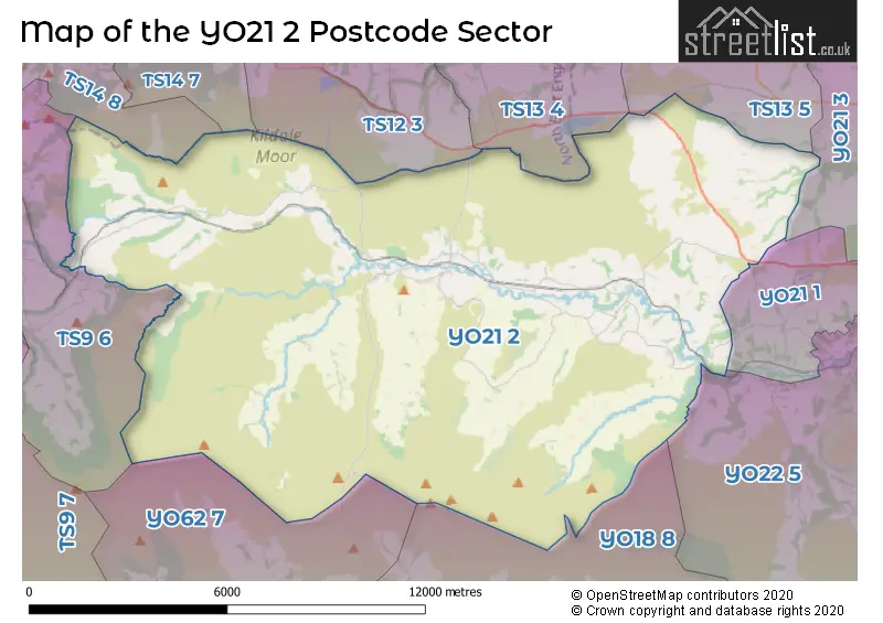
The YO21 2 Postcode shares a border with TS13 5 (Staithes, Hinderwell, Runswick), TS14 7 (GUISBOROUGH), TS9 6 (Great Ayton, Battersby, Newton Under Roseberry), TS12 3 (Lingdale, Boosbeck, Moorsholm), TS13 4 (Loftus, Easington, Carlin How), TS14 8 (GUISBOROUGH), YO18 8 (PICKERING, Middleton, Rosedale Abbey), YO21 1 (WHITBY, Ruswarp, Briggswath), YO21 3 (WHITBY, Sandsend, Lythe), YO22 5 (Sleights, Goathland, Grosmont) and YO62 7 (Nawton, Kirkbymoorside, Wombleton).
Map of the YO21 2 Postcode Sector
Explore the YO21 2 postcode sector by using our interactive map.
The sector is within the post town of WHITBY.
YO21 2 is a postcode sector within the YO21 postcode district which is within the YO York postcode area.
The Royal Mail delivery office for the YO21 2 postal sector is the Whitby Delivery Office and Castleton Scale Payment Delivery Office and Danby Scale Payment Delivery Office and Kildale Scale Payment Delivery Office.
The area of the YO21 2 postcode sector is 77.38 square miles which is 200.42 square kilometres or 49,525.43 square acres.
Waterways within the YO21 2 postcode sector include the River Esk, Glaisdale Beck, Little Fryup Beck, Great Fryup Beck, Danby Beck.
Your support helps keep this site running!
If you enjoy using this website, consider buying me a coffee to help cover hosting costs.


| Y | O | 2 | 1 | - | 2 | X | X |
| Y | O | 2 | 1 | Space | 2 | Letter | Letter |
Official List of Streets
(103 Streets)
Ainthorpe (6 Streets)
Glaisdale (11 Streets)
Castleton (16 Streets)
Danby (10 Streets)
Westerdale (2 Streets)
Ugthorpe (3 Streets)
Lealholm (11 Streets)
Unofficial Streets or Alternative Spellings
Great Ayton
DIKES LANEGlaisdale
GLAISDALE HALL LANELythe
HIGH STREETAinthorpe
LILAC TERRACEWeather Forecast for YO21 2
Weather Forecast for Castleton (North Yorkshire)
| Time Period | Icon | Description | Temperature | Rain Probability | Wind |
|---|---|---|---|---|---|
| 03:00 to 06:00 | Mist | 4.0°C (feels like 2.0°C) | 16.00% | SSW 7 mph | |
| 06:00 to 09:00 | Fog | 5.0°C (feels like 1.0°C) | 16.00% | SSW 11 mph | |
| 09:00 to 12:00 | Cloudy | 5.0°C (feels like 1.0°C) | 4.00% | SSW 11 mph | |
| 12:00 to 15:00 | Cloudy | 7.0°C (feels like 3.0°C) | 5.00% | SSW 13 mph | |
| 15:00 to 18:00 | Cloudy | 7.0°C (feels like 4.0°C) | 5.00% | SSW 11 mph | |
| 18:00 to 21:00 | Cloudy | 6.0°C (feels like 2.0°C) | 5.00% | SSW 16 mph | |
| 21:00 to 00:00 | Cloudy | 5.0°C (feels like 1.0°C) | 5.00% | SSW 16 mph |
| Time Period | Icon | Description | Temperature | Rain Probability | Wind |
|---|---|---|---|---|---|
| 00:00 to 03:00 | Cloudy | 5.0°C (feels like 0.0°C) | 5.00% | SSW 18 mph | |
| 03:00 to 06:00 | Cloudy | 5.0°C (feels like 1.0°C) | 5.00% | SSW 18 mph | |
| 06:00 to 09:00 | Cloudy | 6.0°C (feels like 1.0°C) | 5.00% | SSW 20 mph | |
| 09:00 to 12:00 | Cloudy | 7.0°C (feels like 2.0°C) | 9.00% | SSW 22 mph | |
| 12:00 to 15:00 | Light rain | 8.0°C (feels like 4.0°C) | 48.00% | SSW 22 mph | |
| 15:00 to 18:00 | Light rain | 8.0°C (feels like 5.0°C) | 50.00% | SW 18 mph | |
| 18:00 to 21:00 | Partly cloudy (night) | 7.0°C (feels like 3.0°C) | 11.00% | SW 16 mph | |
| 21:00 to 00:00 | Clear night | 6.0°C (feels like 1.0°C) | 4.00% | SW 16 mph |
| Time Period | Icon | Description | Temperature | Rain Probability | Wind |
|---|---|---|---|---|---|
| 00:00 to 03:00 | Clear night | 5.0°C (feels like 0.0°C) | 3.00% | WSW 16 mph | |
| 03:00 to 06:00 | Clear night | 4.0°C (feels like -1.0°C) | 2.00% | WSW 16 mph | |
| 06:00 to 09:00 | Clear night | 3.0°C (feels like -2.0°C) | 1.00% | WSW 13 mph | |
| 09:00 to 12:00 | Sunny day | 3.0°C (feels like -1.0°C) | 1.00% | WSW 13 mph | |
| 12:00 to 15:00 | Sunny day | 6.0°C (feels like 2.0°C) | 1.00% | W 13 mph | |
| 15:00 to 18:00 | Sunny day | 6.0°C (feels like 3.0°C) | 0.00% | W 11 mph | |
| 18:00 to 21:00 | Clear night | 3.0°C (feels like 0.0°C) | 0.00% | WSW 9 mph | |
| 21:00 to 00:00 | Clear night | 1.0°C (feels like -2.0°C) | 1.00% | SW 7 mph |
| Time Period | Icon | Description | Temperature | Rain Probability | Wind |
|---|---|---|---|---|---|
| 00:00 to 03:00 | Clear night | 1.0°C (feels like -3.0°C) | 1.00% | SW 7 mph | |
| 03:00 to 06:00 | Clear night | 0.0°C (feels like -3.0°C) | 1.00% | SW 4 mph | |
| 06:00 to 09:00 | Clear night | -1.0°C (feels like -4.0°C) | 2.00% | SSW 4 mph | |
| 09:00 to 12:00 | Sunny day | 1.0°C (feels like -1.0°C) | 1.00% | SSW 4 mph | |
| 12:00 to 15:00 | Sunny day | 6.0°C (feels like 5.0°C) | 1.00% | SSW 4 mph | |
| 15:00 to 18:00 | Sunny day | 6.0°C (feels like 5.0°C) | 1.00% | SE 4 mph | |
| 18:00 to 21:00 | Clear night | 1.0°C (feels like -2.0°C) | 1.00% | SE 4 mph | |
| 21:00 to 00:00 | Clear night | 0.0°C (feels like -3.0°C) | 2.00% | SE 7 mph |
Schools and Places of Education Within the YO21 2 Postcode Sector
Danby Church of England Voluntary Aided School
Voluntary aided school
Ainthorpe Lane, Whitby, North Yorkshire, YO21 2NG
Head: Mrs Elisabeth Orland
Ofsted Rating: Good
Inspection: 2022-01-20 (1110 days ago)
Website: Visit Danby Church of England Voluntary Aided School Website
Phone: 01287660345
Number of Pupils: 41
Lealholm Primary School
Academy converter
Lealholm Bank, Whitby, , YO21 2AG
Head: Mrs Christina Zanelli
Ofsted Rating: Good
Inspection: 2022-07-06 (943 days ago)
Website: Visit Lealholm Primary School Website
Phone: 01947897401
Number of Pupils: 31
House Prices in the YO21 2 Postcode Sector
| Type of Property | 2018 Average | 2018 Sales | 2017 Average | 2017 Sales | 2016 Average | 2016 Sales | 2015 Average | 2015 Sales |
|---|---|---|---|---|---|---|---|---|
| Detached | £331,643 | 14 | £299,721 | 12 | £470,500 | 6 | £273,556 | 9 |
| Semi-Detached | £219,950 | 10 | £191,286 | 7 | £235,500 | 4 | £238,000 | 4 |
| Terraced | £170,692 | 13 | £209,995 | 11 | £179,313 | 8 | £184,050 | 10 |
| Flats | £94,000 | 1 | £0 | 0 | £0 | 0 | £0 | 0 |
Important Postcodes YO21 2 in the Postcode Sector
YO21 2NB is the postcode for Tourist Information Centre, The Moors Centre Danby Lodge, Lodge Lane, Danby
YO21 2PA is the postcode for Danby Surgery, Briar Hill
| The YO21 2 Sector is within these Local Authorities |
|
|---|---|
| The YO21 2 Sector is within these Counties |
|
| The YO21 2 Sector is within these Water Company Areas |
|
Tourist Attractions within the YO21 2 Postcode Area
We found 1 visitor attractions within the YO21 postcode area
| The Moors National Park Centre |
|---|
| Visitor Centres |
| Heritage / Visitor Centre |
| View The Moors National Park Centre on Google Maps |