A wide range of spatial data has been analysed to present this overview of the WV6 7 Postcode sector. If you would like anything added, please contact us.
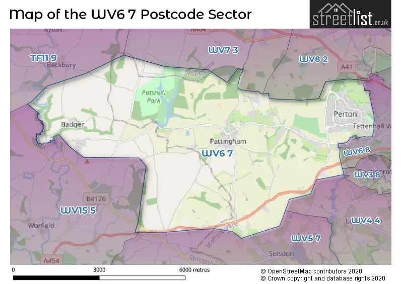
The WV6 7 postcode sector lies where the three counties of Staffordshire, West Midlands, and Shropshire meet.
Did you know? According to the 2021 Census, the WV6 7 postcode sector is home to a bustling 12,579 residents!
Given that each sector allows for 400 unique postcode combinations. Letters C, I, K, M, O and V are not allowed in the last two letters of a postcode. With 304 postcodes already in use, this leaves 96 units available.
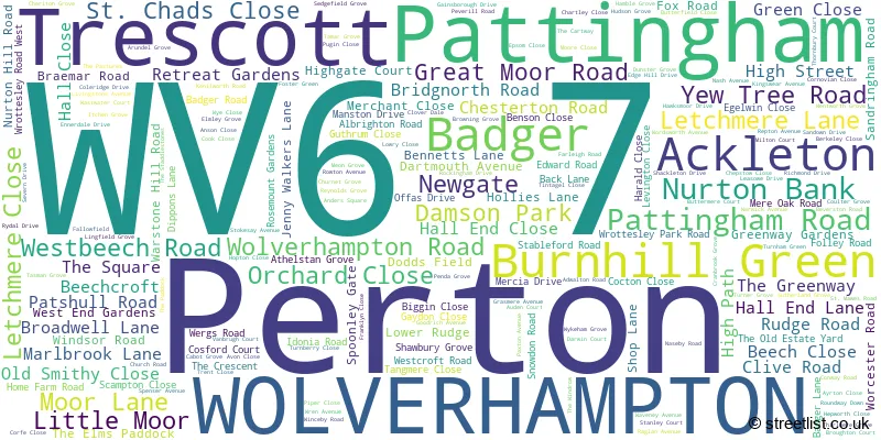
The largest settlement in the WV6 7 postal code is Perton followed by WOLVERHAMPTON, and Pattingham.
The WV6 7 Postcode shares a border with TF11 9 (SHIFNAL, Beckbury, Norton), WV3 8 (WOLVERHAMPTON, Castlecroft), WV4 4 (WOLVERHAMPTON, Penn), WV5 7 (Claverley, Seisdon, Trysull), WV6 9 (WOLVERHAMPTON, Tettenhall), WV7 3 (Albrighton), WV8 2 (Codsall, Oaken, WOLVERHAMPTON), WV6 8 (WOLVERHAMPTON, Tettenhall Wood, Tettenhall) and WV15 5 (BRIDGNORTH, Worfield, The Hobbins).
Map of the WV6 7 Postcode Sector
Explore the WV6 7 postcode sector by using our interactive map.
The sector is within the post town of WOLVERHAMPTON.
WV6 7 is a postcode sector within the WV6 postcode district which is within the WV Wolverhampton postcode area.
The Royal Mail delivery office for the WV6 7 postal sector is the Wolverhampton Nw Delivery Office.
The area of the WV6 7 postcode sector is 17.62 square miles which is 45.64 square kilometres or 11,278.54 square acres.
Waterways within the WV6 7 postcode sector include the Snowdon Brook, Nun Brook, Worfe, River Penk, Nurton Brook, Smestow Brook.
Your support helps keep this site running!
If you enjoy using this website, consider buying me a coffee to help cover hosting costs.


| W | V | 6 | - | 7 | X | X |
| W | V | 6 | Space | 7 | Letter | Letter |
Official List of Streets
WOLVERHAMPTON (83 Streets)
Burnhill Green (4 Streets)
Perton (89 Streets)
Ackleton (5 Streets)
Badger (3 Streets)
Pattingham (51 Streets)
(18 Streets)
Unofficial Streets or Alternative Spellings
WOLVERHAMPTON
CRANMERE AVENUE THE HIGHFIELDS WROTTESLEY PARK ROAD YEW TREE LANEPerton
BOWEN-COOKE AVENUE BIRCHES LANE BLAKLEY POOL LANE BRIARCROFT BUTTTERFIELD CLOSE CLOVERDALE COLLET ROAD FARM ROAD HAMLEY PARK KINGSLOW LANE LEASOWES DRIVE MILLENIUM WALK NAESBY ROAD PATH IN ST MARYS CHURCHYARD PERTON ROAD RIDGE PATH SAINT ANDREWS DRIVE SHEPHERDS PATH SNOWDON LANE THE DRIVE THE RETREAT GARDENS THE SADDLESTONES THE SAND TRACK WATERY LANE WORDSWORTH COURTClaverley
RUDGE HEATH ROADWeather Forecast for WV6 7
Weather Forecast for Wightwick Manor
| Time Period | Icon | Description | Temperature | Rain Probability | Wind |
|---|---|---|---|---|---|
| 12:00 to 15:00 | Cloudy | 7.0°C (feels like 4.0°C) | 9.00% | NW 11 mph | |
| 15:00 to 18:00 | Overcast | 7.0°C (feels like 5.0°C) | 9.00% | NNW 9 mph | |
| 18:00 to 21:00 | Overcast | 6.0°C (feels like 4.0°C) | 8.00% | N 4 mph | |
| 21:00 to 00:00 | Cloudy | 5.0°C (feels like 3.0°C) | 6.00% | NNE 4 mph |
| Time Period | Icon | Description | Temperature | Rain Probability | Wind |
|---|---|---|---|---|---|
| 00:00 to 03:00 | Overcast | 4.0°C (feels like 3.0°C) | 11.00% | ESE 2 mph | |
| 03:00 to 06:00 | Overcast | 4.0°C (feels like 2.0°C) | 11.00% | SSE 2 mph | |
| 06:00 to 09:00 | Overcast | 4.0°C (feels like 2.0°C) | 10.00% | SSE 4 mph | |
| 09:00 to 12:00 | Overcast | 4.0°C (feels like 1.0°C) | 13.00% | SSE 7 mph | |
| 12:00 to 15:00 | Cloudy | 5.0°C (feels like 2.0°C) | 5.00% | S 11 mph | |
| 15:00 to 18:00 | Cloudy | 6.0°C (feels like 3.0°C) | 8.00% | S 9 mph | |
| 18:00 to 21:00 | Cloudy | 5.0°C (feels like 2.0°C) | 5.00% | SSE 9 mph | |
| 21:00 to 00:00 | Cloudy | 4.0°C (feels like 0.0°C) | 8.00% | S 11 mph |
| Time Period | Icon | Description | Temperature | Rain Probability | Wind |
|---|---|---|---|---|---|
| 00:00 to 03:00 | Overcast | 4.0°C (feels like -1.0°C) | 8.00% | S 11 mph | |
| 03:00 to 06:00 | Overcast | 3.0°C (feels like 0.0°C) | 9.00% | S 11 mph | |
| 06:00 to 09:00 | Cloudy | 3.0°C (feels like -1.0°C) | 7.00% | SSE 9 mph | |
| 09:00 to 12:00 | Cloudy | 3.0°C (feels like -1.0°C) | 9.00% | S 9 mph | |
| 12:00 to 15:00 | Cloudy | 5.0°C (feels like 2.0°C) | 7.00% | S 9 mph | |
| 15:00 to 18:00 | Overcast | 6.0°C (feels like 4.0°C) | 10.00% | SSW 9 mph | |
| 18:00 to 21:00 | Overcast | 5.0°C (feels like 3.0°C) | 8.00% | S 7 mph | |
| 21:00 to 00:00 | Partly cloudy (night) | 4.0°C (feels like 1.0°C) | 1.00% | SSW 7 mph |
| Time Period | Icon | Description | Temperature | Rain Probability | Wind |
|---|---|---|---|---|---|
| 00:00 to 03:00 | Cloudy | 3.0°C (feels like 1.0°C) | 5.00% | SSW 7 mph | |
| 03:00 to 06:00 | Cloudy | 3.0°C (feels like 0.0°C) | 6.00% | S 7 mph | |
| 06:00 to 09:00 | Overcast | 3.0°C (feels like 0.0°C) | 8.00% | S 7 mph | |
| 09:00 to 12:00 | Cloudy | 4.0°C (feels like 1.0°C) | 6.00% | S 9 mph | |
| 12:00 to 15:00 | Overcast | 7.0°C (feels like 4.0°C) | 8.00% | SSW 11 mph | |
| 15:00 to 18:00 | Cloudy | 8.0°C (feels like 5.0°C) | 5.00% | SSW 11 mph | |
| 18:00 to 21:00 | Cloudy | 7.0°C (feels like 4.0°C) | 5.00% | S 11 mph | |
| 21:00 to 00:00 | Cloudy | 6.0°C (feels like 3.0°C) | 5.00% | S 11 mph |
| Time Period | Icon | Description | Temperature | Rain Probability | Wind |
|---|---|---|---|---|---|
| 00:00 to 03:00 | Overcast | 6.0°C (feels like 3.0°C) | 11.00% | S 13 mph | |
| 03:00 to 06:00 | Overcast | 7.0°C (feels like 3.0°C) | 16.00% | S 13 mph | |
| 06:00 to 09:00 | Overcast | 7.0°C (feels like 3.0°C) | 19.00% | S 13 mph | |
| 09:00 to 12:00 | Overcast | 7.0°C (feels like 4.0°C) | 21.00% | SSW 13 mph | |
| 12:00 to 15:00 | Light rain | 9.0°C (feels like 6.0°C) | 45.00% | SSW 13 mph | |
| 15:00 to 18:00 | Cloudy | 9.0°C (feels like 7.0°C) | 17.00% | SW 11 mph | |
| 18:00 to 21:00 | Cloudy | 8.0°C (feels like 5.0°C) | 14.00% | WSW 9 mph | |
| 21:00 to 00:00 | Partly cloudy (night) | 6.0°C (feels like 3.0°C) | 7.00% | WSW 9 mph |
Schools and Places of Education Within the WV6 7 Postcode Sector
Perton First School
Community school
Manston Drive, Wolverhampton, Staffordshire, WV6 7LX
Head: Mrs Anne Bennett
Ofsted Rating: Good
Inspection: 2023-02-15 (716 days ago)
Website: Visit Perton First School Website
Phone: 01902500450
Number of Pupils: 286
Perton Middle School
Community school
Gainsborough Drive, Wolverhampton, Staffordshire, WV6 7NR
Head: Mrs Alexandra Dadge
Ofsted Rating: Good
Inspection: 2023-02-03 (728 days ago)
Website: Visit Perton Middle School Website
Phone: 01902758244
Number of Pupils: 444
Perton Primary Academy
Academy converter
Sandown Drive, Wolverhampton, West Midlands, WV6 7PS
Head: Mrs Victoria Jackson
Ofsted Rating: Good
Inspection: 2023-11-08 (450 days ago)
Website: Visit Perton Primary Academy Website
Phone: 01902742686
Number of Pupils: 242
St Chad's CofE (VC) First School
Voluntary controlled school
Pattingham, Wolverhampton, West Midlands, WV6 7AQ
Head: Mrs Sarah Yeomans
Ofsted Rating: Good
Inspection: 2021-11-30 (1158 days ago)
Website: Visit St Chad's CofE (VC) First School Website
Phone: 01902700372
Number of Pupils: 128

House Prices in the WV6 7 Postcode Sector
| Type of Property | 2018 Average | 2018 Sales | 2017 Average | 2017 Sales | 2016 Average | 2016 Sales | 2015 Average | 2015 Sales |
|---|---|---|---|---|---|---|---|---|
| Detached | £304,609 | 79 | £296,661 | 97 | £272,880 | 84 | £249,880 | 102 |
| Semi-Detached | £194,661 | 77 | £181,576 | 71 | £166,951 | 77 | £156,256 | 67 |
| Terraced | £173,533 | 29 | £124,347 | 19 | £178,807 | 14 | £157,877 | 20 |
| Flats | £79,352 | 13 | £91,850 | 14 | £70,422 | 13 | £73,090 | 11 |
Important Postcodes WV6 7 in the Postcode Sector
WV6 7AQ is the postcode for St Chads Church Of England Primary School, Westbeech Road, and Staffordshire County Council, St. Chads C E Primary School, Westbeech Road
WV6 7EH is the postcode for Walford & North Shropshire College, Bridgnorth Road
WV6 7LX is the postcode for Staffordshire County Council, Perton County First School, Manston Drive, and Perton First School, Manston Drive
WV6 7NR is the postcode for Staffordshire County Council, Perton Middle School, Gainsborough Drive
WV6 7PS is the postcode for PERTON PRIMARY ACADEMY, SANDOWN DRIVE, PERTON, and Perton Primary Academy, Sandown Drive
| The WV6 7 Sector is within these Local Authorities |
|
|---|---|
| The WV6 7 Sector is within these Counties |
|
| The WV6 7 Sector is within these Water Company Areas |
|