A wide range of spatial data has been analysed to present this overview of the WS12 0 Postcode sector. If you would like anything added, please contact us.
The WS12 0 Cannock Postcode Sector
The WS12 0 postcode sector is within the county of Staffordshire.
Did you know? According to the 2021 Census, the WS12 0 postcode sector is home to a bustling 3,201 residents!
Given that each sector allows for 400 unique postcode combinations. Letters C, I, K, M, O and V are not allowed in the last two letters of a postcode. With 74 postcodes already in use, this leaves 326 units available.
The largest settlement in the WS12 0 postal code is CANNOCK followed by Hednesford, and Hazel Slade.
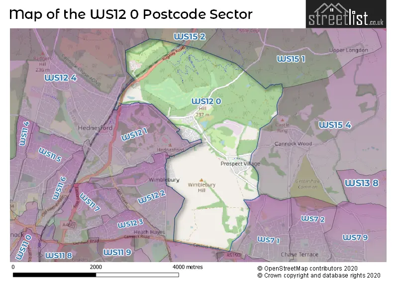
The WS12 0 Postcode shares a border with WS7 1 (BURNTWOOD, Chase Terrace), WS12 1 (Hednesford, CANNOCK), WS12 2 (CANNOCK, Hednesford, Heath Hayes), WS15 1 (Brereton, RUGELEY, Hawksyard), WS15 2 (RUGELEY), WS12 4 (Hednesford, CANNOCK, Huntington), WS15 4 (RUGELEY, Armitage, Handsacre), WS7 3 (BURNTWOOD, Chasetown, Burntwood Business Park) and WS11 9 (Norton Canes, CANNOCK).
Map of the WS12 0 Postcode Sector
Explore the WS12 0 postcode sector by using our interactive map.
The sector is within the post town of CANNOCK.
WS12 0 is a postcode sector within the WS12 postcode district which is within the WS Walsall postcode area.
The Royal Mail delivery office for the WS12 0 postal sector is the unknown.
The area of the WS12 0 postcode sector is 4.24 square miles which is 10.99 square kilometres or 2,714.87 square acres.
Your support helps keep this site running!
If you enjoy using this website, consider buying me a coffee to help cover hosting costs.

| W | S | 1 | 2 | - | 0 | X | X |
| W | S | 1 | 2 | Space | 0 | Letter | Letter |
Official List of Streets
CANNOCK (43 Streets)
Littleworth (1 Streets)
Hednesford (12 Streets)
(3 Streets)
Wimblebury (3 Streets)
Hazel Slade (2 Streets)
Unofficial Streets or Alternative Spellings
RUGELEY
CUMBERLEDGE HILL ABSINTHE BEAU DESERT 13 PATH CHASE VIEW DEER SKULL DEERCOTE SLADE LE SINGE NOIR MONKEYS UNCLE NEW HAYES PARK OVER THE RAINBOW PARSONS SLADE POT OF GOLD RAINBOW VALLEY ROLLERCOASTER THE GULLY THE ORIGINAL MONKEY THE WOODBANK TIGHT SQUEEZE WALKERS RISE WEST CANNOCK WAY WHAT GOES UPCANNOCK
CLAYGATE ROAD SCOTT STREETHednesford
KEYS PARK ROAD LITTLEWORTH ROAD RAWNSLEY ROADChase Terrace
CANNOCK ROADCANNOCK,
SEVENS ROADHeath Hayes
WIMBLEBURY ROADLittleworth
WIMBLEBURY ROADWeather Forecast for WS12 0
Weather Forecast for Hednesford
| Time Period | Icon | Description | Temperature | Rain Probability | Wind |
|---|---|---|---|---|---|
| 09:00 to 12:00 | Cloudy | 12.0°C (feels like 8.0°C) | 9.00% | S 22 mph | |
| 12:00 to 15:00 | Heavy rain | 12.0°C (feels like 9.0°C) | 79.00% | S 22 mph | |
| 15:00 to 18:00 | Cloudy | 12.0°C (feels like 9.0°C) | 63.00% | SSW 20 mph | |
| 18:00 to 21:00 | Cloudy | 10.0°C (feels like 8.0°C) | 6.00% | SSW 11 mph | |
| 21:00 to 00:00 | Cloudy | 9.0°C (feels like 7.0°C) | 6.00% | SSW 9 mph |
| Time Period | Icon | Description | Temperature | Rain Probability | Wind |
|---|---|---|---|---|---|
| 00:00 to 03:00 | Cloudy | 8.0°C (feels like 6.0°C) | 4.00% | SSW 7 mph | |
| 03:00 to 06:00 | Cloudy | 8.0°C (feels like 6.0°C) | 5.00% | SSW 7 mph | |
| 06:00 to 09:00 | Cloudy | 7.0°C (feels like 6.0°C) | 7.00% | SSW 7 mph | |
| 09:00 to 12:00 | Cloudy | 8.0°C (feels like 6.0°C) | 6.00% | SW 7 mph | |
| 12:00 to 15:00 | Light rain shower (day) | 11.0°C (feels like 8.0°C) | 36.00% | WSW 11 mph | |
| 15:00 to 18:00 | Sunny day | 11.0°C (feels like 9.0°C) | 37.00% | WSW 11 mph | |
| 18:00 to 21:00 | Clear night | 9.0°C (feels like 7.0°C) | 7.00% | SW 7 mph | |
| 21:00 to 00:00 | Clear night | 7.0°C (feels like 5.0°C) | 1.00% | SSW 7 mph |
| Time Period | Icon | Description | Temperature | Rain Probability | Wind |
|---|---|---|---|---|---|
| 00:00 to 03:00 | Clear night | 6.0°C (feels like 3.0°C) | 0.00% | SSW 9 mph | |
| 03:00 to 06:00 | Cloudy | 6.0°C (feels like 3.0°C) | 5.00% | S 11 mph | |
| 06:00 to 09:00 | Cloudy | 7.0°C (feels like 3.0°C) | 6.00% | S 16 mph | |
| 09:00 to 12:00 | Cloudy | 8.0°C (feels like 4.0°C) | 6.00% | S 18 mph | |
| 12:00 to 15:00 | Light rain | 10.0°C (feels like 6.0°C) | 44.00% | S 22 mph | |
| 15:00 to 18:00 | Light rain | 10.0°C (feels like 6.0°C) | 59.00% | S 22 mph | |
| 18:00 to 21:00 | Heavy rain | 10.0°C (feels like 6.0°C) | 87.00% | SSW 20 mph | |
| 21:00 to 00:00 | Heavy rain | 10.0°C (feels like 6.0°C) | 82.00% | SSW 18 mph |
| Time Period | Icon | Description | Temperature | Rain Probability | Wind |
|---|---|---|---|---|---|
| 00:00 to 03:00 | Light rain shower (night) | 9.0°C (feels like 6.0°C) | 38.00% | SSW 16 mph | |
| 03:00 to 06:00 | Light rain shower (night) | 9.0°C (feels like 6.0°C) | 35.00% | SW 13 mph | |
| 06:00 to 09:00 | Cloudy | 8.0°C (feels like 5.0°C) | 14.00% | SW 11 mph | |
| 09:00 to 12:00 | Partly cloudy (day) | 8.0°C (feels like 6.0°C) | 11.00% | SW 11 mph | |
| 12:00 to 15:00 | Light rain shower (day) | 10.0°C (feels like 8.0°C) | 35.00% | WSW 13 mph | |
| 15:00 to 18:00 | Sunny day | 10.0°C (feels like 8.0°C) | 13.00% | WSW 13 mph | |
| 18:00 to 21:00 | Clear night | 8.0°C (feels like 5.0°C) | 6.00% | SW 9 mph | |
| 21:00 to 00:00 | Clear night | 6.0°C (feels like 3.0°C) | 3.00% | SW 9 mph |
| Time Period | Icon | Description | Temperature | Rain Probability | Wind |
|---|---|---|---|---|---|
| 00:00 to 03:00 | Clear night | 5.0°C (feels like 2.0°C) | 4.00% | SW 9 mph | |
| 03:00 to 06:00 | Partly cloudy (night) | 4.0°C (feels like 1.0°C) | 6.00% | WSW 9 mph | |
| 06:00 to 09:00 | Partly cloudy (night) | 4.0°C (feels like 1.0°C) | 7.00% | WSW 9 mph | |
| 09:00 to 12:00 | Partly cloudy (day) | 5.0°C (feels like 2.0°C) | 9.00% | WSW 9 mph | |
| 12:00 to 15:00 | Cloudy | 7.0°C (feels like 4.0°C) | 15.00% | W 11 mph | |
| 15:00 to 18:00 | Light rain shower (day) | 8.0°C (feels like 5.0°C) | 33.00% | WNW 11 mph | |
| 18:00 to 21:00 | Clear night | 6.0°C (feels like 3.0°C) | 6.00% | W 9 mph | |
| 21:00 to 00:00 | Partly cloudy (night) | 4.0°C (feels like 1.0°C) | 5.00% | W 9 mph |
Schools and Places of Education Within the WS12 0 Postcode Sector
Hazel Slade Primary Academy
Academy converter
Cannock Wood Street, Cannock, Staffordshire, WS12 0PN
Head: Mrs Katie Challinor
Ofsted Rating: Good
Inspection: 2022-09-14 (891 days ago)
Website: Visit Hazel Slade Primary Academy Website
Phone: 01543227115
Number of Pupils: 209
House Prices in the WS12 0 Postcode Sector
| Type of Property | 2018 Average | 2018 Sales | 2017 Average | 2017 Sales | 2016 Average | 2016 Sales | 2015 Average | 2015 Sales |
|---|---|---|---|---|---|---|---|---|
| Detached | £332,689 | 14 | £313,339 | 22 | £289,306 | 27 | £231,538 | 26 |
| Semi-Detached | £166,800 | 14 | £138,667 | 12 | £141,719 | 18 | £122,938 | 17 |
| Terraced | £166,000 | 7 | £131,417 | 6 | £128,356 | 9 | £113,750 | 4 |
| Flats | £75,500 | 2 | £84,000 | 1 | £0 | 0 | £0 | 0 |
Important Postcodes WS12 0 in the Postcode Sector
WS12 0PN is the postcode for Hazel Slade C P School, Cannock Wood Street
| The WS12 0 Sector is within these Local Authorities |
|
|---|---|
| The WS12 0 Sector is within these Counties |
|
| The WS12 0 Sector is within these Water Company Areas |
|