A wide range of spatial data has been analysed to present this overview of the WN5 8 Postcode sector. If you would like anything added, please contact us.
The WN5 8 postcode sector stands on the Greater Manchester and Lancashire border.
Did you know? According to the 2021 Census, the WN5 8 postcode sector is home to a bustling 11,127 residents!
Given that each sector allows for 400 unique postcode combinations. Letters C, I, K, M, O and V are not allowed in the last two letters of a postcode. With 244 postcodes already in use, this leaves 156 units available.
The largest settlement in the WN5 8 postal code is Orrell followed by WIGAN, and Pemberton.
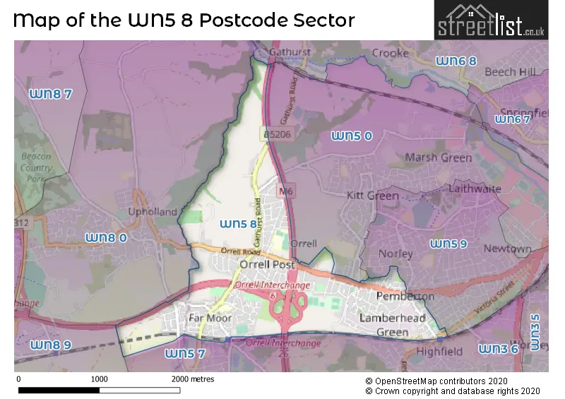
The WN5 8 Postcode shares a border with WN8 9 (SKELMERSDALE, Crawford Village, Upholland), WN5 0 (WIGAN, Orrell, Martland Park), WN5 9 (WIGAN, Newtown), WN3 6 (WIGAN, Winstanley), WN5 7 (Billinge, Orrell), WN6 8 (Shevington, WIGAN, Standish Lower Ground) and WN8 0 (Upholland, SKELMERSDALE, Roby Mill).
Map of the WN5 8 Postcode Sector
Explore the WN5 8 postcode sector by using our interactive map.
The sector is within the post town of WIGAN.
WN5 8 is a postcode sector within the WN5 postcode district which is within the WN Wigan postcode area.
The Royal Mail delivery office for the WN5 8 postal sector is the Wigan Delivery Office.
The area of the WN5 8 postcode sector is 1.88 square miles which is 4.87 square kilometres or 1,203.74 square acres.
The WN5 8 postcode sector is crossed by the M6 motorway.
The WN5 8 postcode sector is crossed by the M58 motorway.
Waterways within the WN5 8 postcode sector include the River Douglas.
Your support helps keep this site running!
If you enjoy using this website, consider buying me a coffee to help cover hosting costs.

| W | N | 5 | - | 8 | X | X |
| W | N | 5 | Space | 8 | Letter | Letter |
Official List of Streets
Orrell (116 Streets)
Pemberton (13 Streets)
WIGAN (44 Streets)
(16 Streets)
Winstanley (1 Streets)
Unofficial Streets or Alternative Spellings
Weather Forecast for WN5 8
Weather Forecast for Orrell
| Time Period | Icon | Description | Temperature | Rain Probability | Wind |
|---|---|---|---|---|---|
| 21:00 to 00:00 | Cloudy | 7.0°C (feels like 4.0°C) | 8.00% | SSE 11 mph |
| Time Period | Icon | Description | Temperature | Rain Probability | Wind |
|---|---|---|---|---|---|
| 00:00 to 03:00 | Cloudy | 7.0°C (feels like 3.0°C) | 7.00% | SSE 13 mph | |
| 03:00 to 06:00 | Cloudy | 7.0°C (feels like 4.0°C) | 11.00% | SSE 13 mph | |
| 06:00 to 09:00 | Cloudy | 8.0°C (feels like 4.0°C) | 11.00% | SSE 13 mph | |
| 09:00 to 12:00 | Cloudy | 8.0°C (feels like 5.0°C) | 18.00% | S 13 mph | |
| 12:00 to 15:00 | Cloudy | 9.0°C (feels like 6.0°C) | 52.00% | S 16 mph | |
| 15:00 to 18:00 | Heavy rain | 9.0°C (feels like 6.0°C) | 91.00% | WSW 11 mph | |
| 18:00 to 21:00 | Partly cloudy (night) | 7.0°C (feels like 4.0°C) | 34.00% | SW 11 mph | |
| 21:00 to 00:00 | Clear night | 6.0°C (feels like 3.0°C) | 2.00% | WSW 11 mph |
| Time Period | Icon | Description | Temperature | Rain Probability | Wind |
|---|---|---|---|---|---|
| 00:00 to 03:00 | Clear night | 5.0°C (feels like 2.0°C) | 2.00% | WSW 11 mph | |
| 03:00 to 06:00 | Partly cloudy (night) | 5.0°C (feels like 2.0°C) | 36.00% | WSW 11 mph | |
| 06:00 to 09:00 | Partly cloudy (night) | 5.0°C (feels like 1.0°C) | 2.00% | WSW 9 mph | |
| 09:00 to 12:00 | Cloudy | 5.0°C (feels like 3.0°C) | 5.00% | W 7 mph | |
| 12:00 to 15:00 | Cloudy | 7.0°C (feels like 4.0°C) | 5.00% | W 9 mph | |
| 15:00 to 18:00 | Sunny day | 7.0°C (feels like 5.0°C) | 1.00% | WNW 9 mph | |
| 18:00 to 21:00 | Clear night | 4.0°C (feels like 2.0°C) | 1.00% | WNW 4 mph | |
| 21:00 to 00:00 | Clear night | 2.0°C (feels like 1.0°C) | 1.00% | WSW 2 mph |
| Time Period | Icon | Description | Temperature | Rain Probability | Wind |
|---|---|---|---|---|---|
| 00:00 to 03:00 | Clear night | 1.0°C (feels like 0.0°C) | 1.00% | ESE 2 mph | |
| 03:00 to 06:00 | Clear night | 0.0°C (feels like -1.0°C) | 2.00% | ESE 4 mph | |
| 06:00 to 09:00 | Clear night | -1.0°C (feels like -3.0°C) | 3.00% | ESE 4 mph | |
| 09:00 to 12:00 | Sunny day | 0.0°C (feels like -2.0°C) | 2.00% | ESE 4 mph | |
| 12:00 to 15:00 | Sunny day | 5.0°C (feels like 3.0°C) | 0.00% | SE 4 mph | |
| 15:00 to 18:00 | Sunny day | 7.0°C (feels like 5.0°C) | 0.00% | ESE 7 mph | |
| 18:00 to 21:00 | Clear night | 4.0°C (feels like 2.0°C) | 0.00% | ESE 7 mph | |
| 21:00 to 00:00 | Clear night | 3.0°C (feels like 0.0°C) | 0.00% | ESE 7 mph |
| Time Period | Icon | Description | Temperature | Rain Probability | Wind |
|---|---|---|---|---|---|
| 00:00 to 03:00 | Clear night | 1.0°C (feels like -1.0°C) | 0.00% | ESE 7 mph | |
| 03:00 to 06:00 | Clear night | 1.0°C (feels like -2.0°C) | 1.00% | ESE 7 mph | |
| 06:00 to 09:00 | Clear night | 0.0°C (feels like -3.0°C) | 2.00% | E 4 mph | |
| 09:00 to 12:00 | Sunny day | 1.0°C (feels like -2.0°C) | 2.00% | E 7 mph | |
| 12:00 to 15:00 | Sunny day | 4.0°C (feels like 2.0°C) | 1.00% | ESE 7 mph | |
| 15:00 to 18:00 | Sunny day | 6.0°C (feels like 3.0°C) | 1.00% | ESE 7 mph | |
| 18:00 to 21:00 | Clear night | 3.0°C (feels like 1.0°C) | 1.00% | E 7 mph | |
| 21:00 to 00:00 | Clear night | 2.0°C (feels like -1.0°C) | 1.00% | E 7 mph |
Schools and Places of Education Within the WN5 8 Postcode Sector
Orrell Holgate Academy
Academy converter
Moor Road, Wigan, Lancashire, WN5 8SJ
Head: Mrs Gail Worrall
Ofsted Rating: Good
Inspection: 2019-09-26 (1957 days ago)
Website: Visit Orrell Holgate Academy Website
Phone: 01942776670
Number of Pupils: 213
St Peter's Catholic High School
Voluntary aided school
Howards Lane, Wigan, Lancashire, WN5 8NU
Head: Mr Andrew McGlown
Ofsted Rating: Good
Inspection: 2019-02-27 (2168 days ago)
Website: Visit St Peter's Catholic High School Website
Phone: 01942747693
Number of Pupils: 1036
House Prices in the WN5 8 Postcode Sector
| Type of Property | 2018 Average | 2018 Sales | 2017 Average | 2017 Sales | 2016 Average | 2016 Sales | 2015 Average | 2015 Sales |
|---|---|---|---|---|---|---|---|---|
| Detached | £270,253 | 32 | £234,974 | 40 | £241,571 | 59 | £240,221 | 55 |
| Semi-Detached | £149,478 | 92 | £148,049 | 92 | £140,294 | 87 | £132,700 | 79 |
| Terraced | £116,115 | 52 | £110,814 | 65 | £100,722 | 55 | £105,459 | 58 |
| Flats | £113,333 | 3 | £102,917 | 6 | £79,599 | 5 | £63,875 | 4 |
Important Postcodes WN5 8 in the Postcode Sector
WN5 8NU is the postcode for MAIN BLOCK, St. Peters RC High School, Howards Lane, SPORTS HALL, St. Peters RC High School, Howards Lane, and MUSIC & DRAMA, St. Peter's RC High School, Howard's Lane
WN5 8SJ is the postcode for Orrell Holgate Primary School, Moor Road, and MAIN BUILDING, Orrell Holgate Primary School, Moor Road
| The WN5 8 Sector is within these Local Authorities |
|
|---|---|
| The WN5 8 Sector is within these Counties |
|
| The WN5 8 Sector is within these Water Company Areas |
|