A wide range of spatial data has been analysed to present this overview of the WN2 2 Postcode sector. If you would like anything added, please contact us.
The WN2 2 postcode sector is within the county of Greater Manchester.
Did you know? According to the 2021 Census, the WN2 2 postcode sector is home to a bustling 8,081 residents!
Given that each sector allows for 400 unique postcode combinations. Letters C, I, K, M, O and V are not allowed in the last two letters of a postcode. With 206 postcodes already in use, this leaves 194 units available.
The largest settlement in the WN2 2 postal code is Ince followed by Hindley, and Aspull.
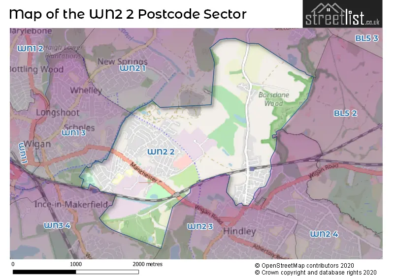
The WN2 2 Postcode shares a border with WN1 3 (WIGAN, Ince), WN2 3 (Hindley, Platt Bridge), WN3 4 (Ince, WIGAN), BL5 2 (Westhoughton), WN2 1 (Aspull, WIGAN, Haigh) and WN2 4 (Hindley Green, Hindley, Bickershaw).
Map of the WN2 2 Postcode Sector
Explore the WN2 2 postcode sector by using our interactive map.
The sector is within the post town of WIGAN.
WN2 2 is a postcode sector within the WN2 postcode district which is within the WN Wigan postcode area.
The Royal Mail delivery office for the WN2 2 postal sector is the Wigan Delivery Office.
The area of the WN2 2 postcode sector is 2.22 square miles which is 5.74 square kilometres or 1,419.37 square acres.
Waterways within the WN2 2 postcode sector include the Leeds and Liverpool Canal.
Your support helps keep this site running!
If you enjoy using this website, consider buying me a coffee to help cover hosting costs.


| W | N | 2 | - | 2 | X | X |
| W | N | 2 | Space | 2 | Letter | Letter |
Official List of Streets
Ince (104 Streets)
(23 Streets)
Aspull (8 Streets)
Hindley (37 Streets)
Unofficial Streets or Alternative Spellings
Weather Forecast for WN2 2
Weather Forecast for Hindley
| Time Period | Icon | Description | Temperature | Rain Probability | Wind |
|---|---|---|---|---|---|
| 15:00 to 18:00 | Cloudy | 7.0°C (feels like 4.0°C) | 3.00% | SSE 11 mph | |
| 18:00 to 21:00 | Partly cloudy (night) | 5.0°C (feels like 2.0°C) | 0.00% | SE 9 mph | |
| 21:00 to 00:00 | Cloudy | 5.0°C (feels like 2.0°C) | 8.00% | SE 9 mph |
| Time Period | Icon | Description | Temperature | Rain Probability | Wind |
|---|---|---|---|---|---|
| 00:00 to 03:00 | Overcast | 6.0°C (feels like 2.0°C) | 9.00% | SSE 11 mph | |
| 03:00 to 06:00 | Overcast | 5.0°C (feels like 1.0°C) | 9.00% | SSE 11 mph | |
| 06:00 to 09:00 | Overcast | 5.0°C (feels like 1.0°C) | 9.00% | SSE 11 mph | |
| 09:00 to 12:00 | Cloudy | 5.0°C (feels like 1.0°C) | 11.00% | SSE 11 mph | |
| 12:00 to 15:00 | Overcast | 6.0°C (feels like 3.0°C) | 11.00% | SSE 9 mph | |
| 15:00 to 18:00 | Overcast | 7.0°C (feels like 5.0°C) | 13.00% | SSE 7 mph | |
| 18:00 to 21:00 | Overcast | 6.0°C (feels like 5.0°C) | 12.00% | SE 4 mph | |
| 21:00 to 00:00 | Overcast | 6.0°C (feels like 4.0°C) | 9.00% | S 4 mph |
| Time Period | Icon | Description | Temperature | Rain Probability | Wind |
|---|---|---|---|---|---|
| 00:00 to 03:00 | Overcast | 6.0°C (feels like 4.0°C) | 9.00% | S 4 mph | |
| 03:00 to 06:00 | Cloudy | 5.0°C (feels like 3.0°C) | 8.00% | S 4 mph | |
| 06:00 to 09:00 | Cloudy | 4.0°C (feels like 1.0°C) | 4.00% | SSE 7 mph | |
| 09:00 to 12:00 | Cloudy | 4.0°C (feels like 1.0°C) | 4.00% | SSE 7 mph | |
| 12:00 to 15:00 | Cloudy | 7.0°C (feels like 5.0°C) | 4.00% | S 9 mph | |
| 15:00 to 18:00 | Cloudy | 9.0°C (feels like 7.0°C) | 4.00% | S 9 mph | |
| 18:00 to 21:00 | Cloudy | 7.0°C (feels like 5.0°C) | 5.00% | S 11 mph | |
| 21:00 to 00:00 | Cloudy | 6.0°C (feels like 3.0°C) | 5.00% | S 11 mph |
| Time Period | Icon | Description | Temperature | Rain Probability | Wind |
|---|---|---|---|---|---|
| 00:00 to 03:00 | Cloudy | 7.0°C (feels like 3.0°C) | 5.00% | S 11 mph | |
| 03:00 to 06:00 | Overcast | 7.0°C (feels like 4.0°C) | 9.00% | S 11 mph | |
| 06:00 to 09:00 | Cloudy | 7.0°C (feels like 4.0°C) | 11.00% | S 11 mph | |
| 09:00 to 12:00 | Cloudy | 8.0°C (feels like 5.0°C) | 20.00% | S 11 mph | |
| 12:00 to 15:00 | Light rain | 9.0°C (feels like 6.0°C) | 53.00% | SSW 11 mph | |
| 15:00 to 18:00 | Light rain | 10.0°C (feels like 7.0°C) | 52.00% | SW 11 mph | |
| 18:00 to 21:00 | Clear night | 8.0°C (feels like 6.0°C) | 12.00% | SW 9 mph | |
| 21:00 to 00:00 | Clear night | 7.0°C (feels like 4.0°C) | 6.00% | WSW 9 mph |
| Time Period | Icon | Description | Temperature | Rain Probability | Wind |
|---|---|---|---|---|---|
| 00:00 to 03:00 | Clear night | 6.0°C (feels like 3.0°C) | 4.00% | W 9 mph | |
| 03:00 to 06:00 | Clear night | 5.0°C (feels like 2.0°C) | 2.00% | W 9 mph | |
| 06:00 to 09:00 | Clear night | 4.0°C (feels like 2.0°C) | 2.00% | WSW 7 mph | |
| 09:00 to 12:00 | Cloudy | 4.0°C (feels like 3.0°C) | 5.00% | SW 4 mph | |
| 12:00 to 15:00 | Cloudy | 7.0°C (feels like 5.0°C) | 4.00% | WSW 4 mph | |
| 15:00 to 18:00 | Sunny day | 8.0°C (feels like 6.0°C) | 1.00% | WSW 7 mph | |
| 18:00 to 21:00 | Clear night | 5.0°C (feels like 3.0°C) | 1.00% | SW 4 mph | |
| 21:00 to 00:00 | Clear night | 3.0°C (feels like 2.0°C) | 1.00% | SSE 4 mph |
Schools and Places of Education Within the WN2 2 Postcode Sector
Ince CofE Primary School
Voluntary aided school
Charles Street, Wigan, Lancashire, WN2 2AL
Head: Mrs Sara Lawrenson
Ofsted Rating: Good
Inspection: 2023-09-13 (507 days ago)
Website: Visit Ince CofE Primary School Website
Phone: 01942704129
Number of Pupils: 401
St William's Catholic Primary School
Voluntary aided school
Ince Green Lane, Wigan, Lancashire, WN2 2DG
Head: Mrs Emily Ellis
Ofsted Rating: Good
Inspection: 2023-12-14 (415 days ago)
Website: Visit St William's Catholic Primary School Website
Phone: 01942235782
Number of Pupils: 219
House Prices in the WN2 2 Postcode Sector
| Type of Property | 2018 Average | 2018 Sales | 2017 Average | 2017 Sales | 2016 Average | 2016 Sales | 2015 Average | 2015 Sales |
|---|---|---|---|---|---|---|---|---|
| Detached | £175,559 | 17 | £207,538 | 12 | £214,516 | 15 | £193,176 | 17 |
| Semi-Detached | £122,849 | 48 | £105,444 | 36 | £114,418 | 46 | £100,786 | 38 |
| Terraced | £73,386 | 42 | £77,499 | 47 | £69,366 | 38 | £82,964 | 29 |
| Flats | £0 | 0 | £143,500 | 2 | £0 | 0 | £90,000 | 1 |
Important Postcodes WN2 2 in the Postcode Sector
WN2 2AL is the postcode for Ince in Makerfield C of E Junior & Infant School, Charles Street, Ince, and Ince in Makerfield C of E Junior & Infant School, Charles Street
WN2 2DG is the postcode for MAIN BUILDING, St. Williams RC School, Ince Green Lane, and St. Williams RC School, Ince Green Lane
WN2 2DJ is the postcode for Ince Community Resourse Centre, Manchester Road
WN2 2JA is the postcode for Child & Family Mental Health Service, 155-157 Manchester Road
WN2 2QG is the postcode for Pennygate Medical Centre, 109 Ladies Lane, and Pennygate Medical Centre, 109 Ladies Lane, Hindley
| The WN2 2 Sector is within these Local Authorities |
|
|---|---|
| The WN2 2 Sector is within these Counties |
|
| The WN2 2 Sector is within these Water Company Areas |
|