A wide range of spatial data has been analysed to present this overview of the WF17 7 Postcode sector. If you would like anything added, please contact us.
The WF17 7 postcode sector is within the county of West Yorkshire.
Did you know? According to the 2021 Census, the WF17 7 postcode sector is home to a bustling 12,222 residents!
Given that each sector allows for 400 unique postcode combinations. Letters C, I, K, M, O and V are not allowed in the last two letters of a postcode. With 219 postcodes already in use, this leaves 181 units available.
The WF17 7 postal code covers the settlement of BATLEY.
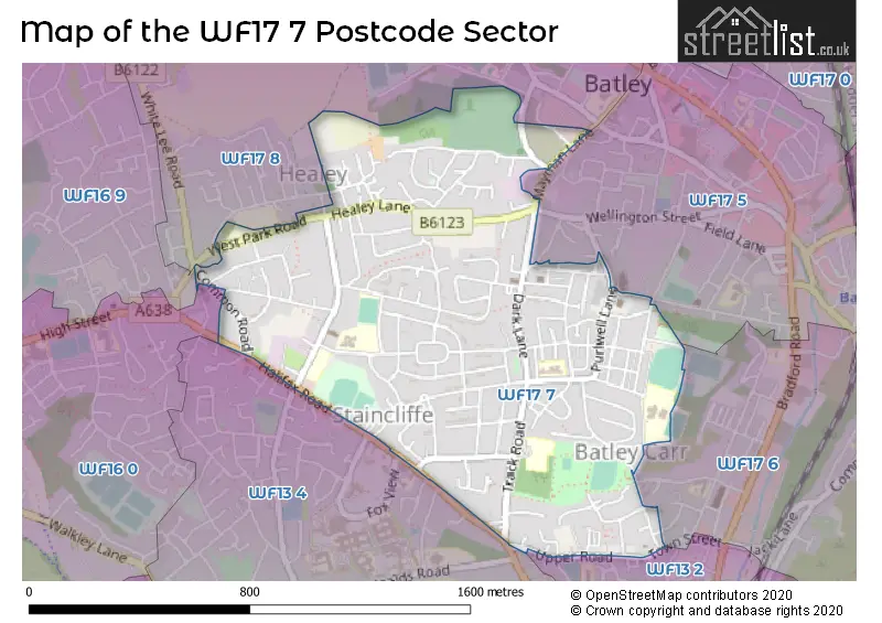
The WF17 7 Postcode shares a border with WF13 2 (DEWSBURY, Westtown, Batley Carr), WF13 4 (DEWSBURY, Staincliffe), WF16 0 (HECKMONDWIKE), WF16 9 (HECKMONDWIKE), WF17 6 (BATLEY, Soothill, Hanging Heaton), WF17 8 (BATLEY) and WF17 5 (BATLEY).
Map of the WF17 7 Postcode Sector
Explore the WF17 7 postcode sector by using our interactive map.
The sector is within the post town of BATLEY.
WF17 7 is a postcode sector within the WF17 postcode district which is within the WF Wakefield postcode area.
The Royal Mail delivery office for the WF17 7 postal sector is the Batley Delivery Office.
The area of the WF17 7 postcode sector is 0.67 square miles which is 1.73 square kilometres or 428.42 square acres.
Your support helps keep this site running!
If you enjoy using this website, consider buying me a coffee to help cover hosting costs.


| W | F | 1 | 7 | - | 7 | X | X |
| W | F | 1 | 7 | Space | 7 | Letter | Letter |
Official List of Streets
BATLEY (122 Streets)
(10 Streets)
Healey (1 Streets)
Staincliffe (1 Streets)
Unofficial Streets or Alternative Spellings
BATLEY
CEMETERY ROAD CONWAY CRESCENT MAYMAN CLOSE SPRINGFIELD AVENUE TAYLOR STREET VICTORIA AVENUE WELLINGTON STREET BACK NORFOLK STREET BACK PURLWELL HALL ROAD BACK PURLWELL LANE BACK PURLWELL ROAD BACK SNOWDON STREET BONACCORD TERRACE BROWNS PLACE HIGH CROFT STAINCLIFFE MILL YARD UPPER BLAKERIDGE LANEStaincliffe
FOX VIEW HALIFAX ROAD WILLIAM STREETDEWSBURY
DEWSBURY GATE ROAD GARNETT STREET HIGHFIELD LANE THE AVENUEBATLEY,
UPPER ROAD WHITE LEE ROADHECKMONDWIKE
BATLEY ROAD THE CROFTSBatley Carr
TOWN STREETWeather Forecast for WF17 7
Weather Forecast for Batley
| Time Period | Icon | Description | Temperature | Rain Probability | Wind |
|---|---|---|---|---|---|
| 03:00 to 06:00 | Overcast | 7.0°C (feels like 5.0°C) | 8.00% | SW 4 mph | |
| 06:00 to 09:00 | Cloudy | 6.0°C (feels like 4.0°C) | 4.00% | SW 7 mph | |
| 09:00 to 12:00 | Cloudy | 5.0°C (feels like 3.0°C) | 3.00% | SW 7 mph | |
| 12:00 to 15:00 | Cloudy | 8.0°C (feels like 6.0°C) | 5.00% | SW 9 mph | |
| 15:00 to 18:00 | Cloudy | 9.0°C (feels like 7.0°C) | 5.00% | SSW 9 mph | |
| 18:00 to 21:00 | Cloudy | 7.0°C (feels like 5.0°C) | 5.00% | S 7 mph | |
| 21:00 to 00:00 | Cloudy | 7.0°C (feels like 4.0°C) | 5.00% | SSW 11 mph |
| Time Period | Icon | Description | Temperature | Rain Probability | Wind |
|---|---|---|---|---|---|
| 00:00 to 03:00 | Cloudy | 7.0°C (feels like 4.0°C) | 5.00% | S 9 mph | |
| 03:00 to 06:00 | Cloudy | 7.0°C (feels like 5.0°C) | 5.00% | S 9 mph | |
| 06:00 to 09:00 | Cloudy | 8.0°C (feels like 5.0°C) | 7.00% | SSW 13 mph | |
| 09:00 to 12:00 | Cloudy | 8.0°C (feels like 5.0°C) | 13.00% | SSW 13 mph | |
| 12:00 to 15:00 | Light rain | 9.0°C (feels like 6.0°C) | 55.00% | SSW 13 mph | |
| 15:00 to 18:00 | Heavy rain | 10.0°C (feels like 7.0°C) | 79.00% | SW 11 mph | |
| 18:00 to 21:00 | Light rain shower (night) | 8.0°C (feels like 6.0°C) | 33.00% | SW 11 mph | |
| 21:00 to 00:00 | Clear night | 7.0°C (feels like 4.0°C) | 7.00% | WSW 11 mph |
| Time Period | Icon | Description | Temperature | Rain Probability | Wind |
|---|---|---|---|---|---|
| 00:00 to 03:00 | Clear night | 6.0°C (feels like 3.0°C) | 4.00% | WSW 11 mph | |
| 03:00 to 06:00 | Clear night | 5.0°C (feels like 2.0°C) | 2.00% | WSW 11 mph | |
| 06:00 to 09:00 | Cloudy | 5.0°C (feels like 2.0°C) | 4.00% | WSW 9 mph | |
| 09:00 to 12:00 | Sunny day | 5.0°C (feels like 2.0°C) | 1.00% | WSW 7 mph | |
| 12:00 to 15:00 | Cloudy | 7.0°C (feels like 4.0°C) | 3.00% | W 9 mph | |
| 15:00 to 18:00 | Partly cloudy (day) | 8.0°C (feels like 5.0°C) | 1.00% | W 9 mph | |
| 18:00 to 21:00 | Clear night | 5.0°C (feels like 3.0°C) | 0.00% | W 7 mph | |
| 21:00 to 00:00 | Clear night | 4.0°C (feels like 2.0°C) | 1.00% | W 4 mph |
| Time Period | Icon | Description | Temperature | Rain Probability | Wind |
|---|---|---|---|---|---|
| 00:00 to 03:00 | Clear night | 3.0°C (feels like 1.0°C) | 1.00% | W 4 mph | |
| 03:00 to 06:00 | Clear night | 2.0°C (feels like 0.0°C) | 2.00% | W 4 mph | |
| 06:00 to 09:00 | Clear night | 1.0°C (feels like -1.0°C) | 4.00% | WNW 2 mph | |
| 09:00 to 12:00 | Sunny day | 1.0°C (feels like -1.0°C) | 4.00% | NW 2 mph | |
| 12:00 to 15:00 | Sunny day | 5.0°C (feels like 4.0°C) | 1.00% | NW 2 mph | |
| 15:00 to 18:00 | Sunny day | 7.0°C (feels like 6.0°C) | 1.00% | E 4 mph | |
| 18:00 to 21:00 | Clear night | 4.0°C (feels like 3.0°C) | 1.00% | E 4 mph | |
| 21:00 to 00:00 | Clear night | 3.0°C (feels like 1.0°C) | 1.00% | ENE 4 mph |
Schools and Places of Education Within the WF17 7 Postcode Sector
Hyrstmount Junior School
Community school
Highcliffe Road, Batley, West Yorkshire, WF17 7NS
Head: Mr Matthew Leach
Ofsted Rating: Good
Inspection: 2021-11-12 (1179 days ago)
Website: Visit Hyrstmount Junior School Website
Phone: 01924326700
Number of Pupils: 280
Purlwell Infant and Nursery School
Community school
Purlwell Lane, Batley, West Yorkshire, WF17 7PE
Head: Mrs Safeena Nazam
Ofsted Rating: Good
Inspection: 2022-03-24 (1047 days ago)
Website: Visit Purlwell Infant and Nursery School Website
Phone: 01924326734
Number of Pupils: 235
Staincliffe Church of England Voluntary Controlled Junior School
Voluntary controlled school
Staincliffe Hall Road, Batley, West Yorkshire, WF17 7QX
Head: Mr Paul Dixon
Ofsted Rating: Good
Inspection: 2023-03-08 (698 days ago)
Website: Visit Staincliffe Church of England Voluntary Controlled Junior School Website
Phone: 01924326756
Number of Pupils: 342
House Prices in the WF17 7 Postcode Sector
| Type of Property | 2018 Average | 2018 Sales | 2017 Average | 2017 Sales | 2016 Average | 2016 Sales | 2015 Average | 2015 Sales |
|---|---|---|---|---|---|---|---|---|
| Detached | £326,000 | 5 | £193,455 | 11 | £183,500 | 4 | £178,557 | 5 |
| Semi-Detached | £140,538 | 28 | £127,009 | 28 | £127,632 | 19 | £117,548 | 31 |
| Terraced | £94,607 | 42 | £88,131 | 51 | £99,807 | 29 | £82,140 | 25 |
| Flats | £56,200 | 3 | £57,333 | 3 | £64,165 | 6 | £51,667 | 3 |
Important Postcodes WF17 7 in the Postcode Sector
WF17 7DQ is the postcode for Manorfield I & N School, Manor Way, and NURSERY/CHILDREN'S CENTRE, Manorfield I & N School, Manor Way
WF17 7EL is the postcode for Healey Community Centre, West Park Road
WF17 7NS is the postcode for Hyrstmount Junior School, Highcliffe Road
WF17 7PE is the postcode for Purlwell Infant & Nursery School, Purlwell Lane
WF17 7QX is the postcode for STAINCLIFFE CE VC JUNIOR SCHOOL, STAINCLIFFE HALL ROAD, STAINCLIFFE, and Staincliffe CE Junior School, Staincliffe Hall Road
WF17 7TB is the postcode for Milen Day Centre, Woodwell House
| The WF17 7 Sector is within these Local Authorities |
|
|---|---|
| The WF17 7 Sector is within these Counties |
|
| The WF17 7 Sector is within these Water Company Areas |
|