A wide range of spatial data has been analysed to present this overview of the WF14 0 Postcode sector. If you would like anything added, please contact us.
The WF14 0 postcode sector is within the county of West Yorkshire.
Did you know? According to the 2021 Census, the WF14 0 postcode sector is home to a bustling 7,391 residents!
Given that each sector allows for 400 unique postcode combinations. Letters C, I, K, M, O and V are not allowed in the last two letters of a postcode. With 187 postcodes already in use, this leaves 213 units available.
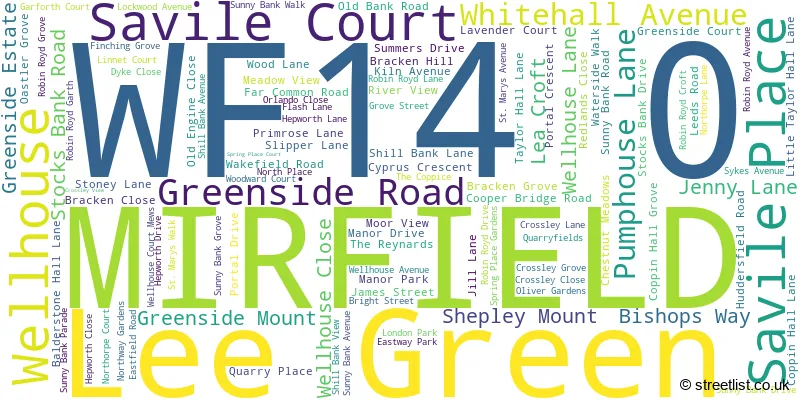
The WF14 0 postal code covers the settlement of MIRFIELD.
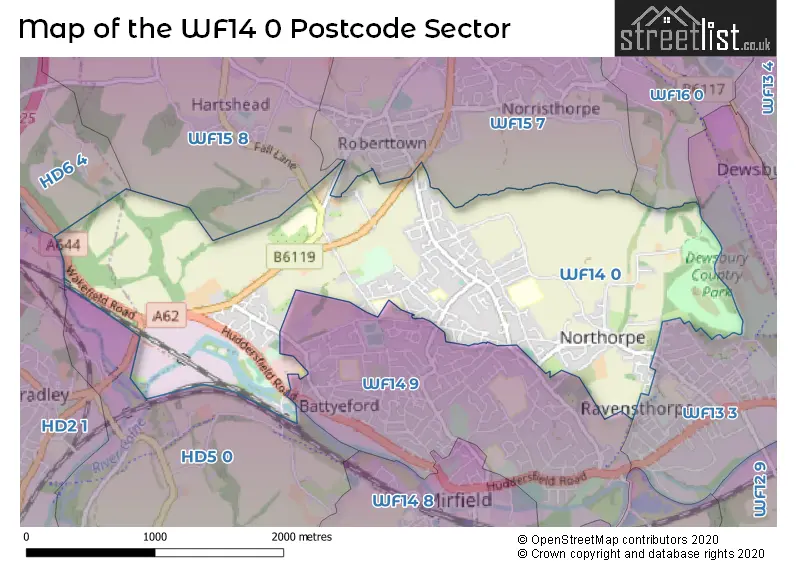
The WF14 0 Postcode shares a border with WF14 9 (MIRFIELD), WF15 8 (LIVERSEDGE, Hartshead, Hightown), WF16 0 (HECKMONDWIKE), WF13 3 (DEWSBURY, Ravensthorpe, Dewsbury Moor), WF15 7 (LIVERSEDGE), HD2 1 (HUDDERSFIELD, Bradley, Fartown), HD5 0 (HUDDERSFIELD, Kirkheaton, Tandem) and HD6 4 (BRIGHOUSE, Bailiff Bridge, Clifton).
Map of the WF14 0 Postcode Sector
Explore the WF14 0 postcode sector by using our interactive map.
The sector is within the post town of MIRFIELD.
WF14 0 is a postcode sector within the WF14 postcode district which is within the WF Wakefield postcode area.
The Royal Mail delivery office for the WF14 0 postal sector is the Calderway Delivery Office.
The area of the WF14 0 postcode sector is 2.34 square miles which is 6.06 square kilometres or 1,496.57 square acres.
Waterways within the WF14 0 postcode sector include the River Calder, Calder and Hebble, spen beck.
Your support helps keep this site running!
If you enjoy using this website, consider buying me a coffee to help cover hosting costs.

| W | F | 1 | 4 | - | 0 | X | X |
| W | F | 1 | 4 | Space | 0 | Letter | Letter |
Official List of Streets
MIRFIELD (106 Streets)
Unofficial Streets or Alternative Spellings
MIRFIELD
HOLMDENE DRIVE KITSON HILL ROAD PRATT LANE WATER ROYD LANE WEST ROYD AVENUE BATTYEFORD HAULING BRIDGE CALDER VALLEY GREENWAY COOPER BRIDGE LOCK BRIDGE COOPER BRIDGE ROUNDABOUT CUT END BRIDGE EASTWAY GREEN SIDE ESTATE LTTLE TAYLOR HALL LANE NORTHWAY NORTHWAY CRESCENT SOUTHWAY STOCKSBANK DRIVE THE ORCHARDS WESTWAYLIVERSEDGE
HUDDERSFIELD ROAD ROBERTTOWN LANEHartshead
FALL LANEDEWSBURY
NORTH ROADDEWSBURY,
HUDDERSFIELD ROADColnebridge
WOOD LANEBRIGHOUSE,
WAKEFIELD ROADWeather Forecast for WF14 0
Weather Forecast for Dewsbury Moor
| Time Period | Icon | Description | Temperature | Rain Probability | Wind |
|---|---|---|---|---|---|
| 18:00 to 21:00 | Cloudy | 8.0°C (feels like 5.0°C) | 5.00% | SSW 9 mph | |
| 21:00 to 00:00 | Cloudy | 7.0°C (feels like 4.0°C) | 5.00% | SSW 11 mph |
| Time Period | Icon | Description | Temperature | Rain Probability | Wind |
|---|---|---|---|---|---|
| 00:00 to 03:00 | Cloudy | 7.0°C (feels like 5.0°C) | 8.00% | S 7 mph | |
| 03:00 to 06:00 | Cloudy | 8.0°C (feels like 5.0°C) | 6.00% | S 9 mph | |
| 06:00 to 09:00 | Cloudy | 8.0°C (feels like 5.0°C) | 9.00% | S 9 mph | |
| 09:00 to 12:00 | Cloudy | 9.0°C (feels like 5.0°C) | 16.00% | SSW 13 mph | |
| 12:00 to 15:00 | Cloudy | 10.0°C (feels like 7.0°C) | 27.00% | SSW 16 mph | |
| 15:00 to 18:00 | Heavy rain | 10.0°C (feels like 7.0°C) | 86.00% | SW 13 mph | |
| 18:00 to 21:00 | Partly cloudy (night) | 8.0°C (feels like 6.0°C) | 8.00% | SW 9 mph | |
| 21:00 to 00:00 | Clear night | 7.0°C (feels like 3.0°C) | 10.00% | WSW 11 mph |
| Time Period | Icon | Description | Temperature | Rain Probability | Wind |
|---|---|---|---|---|---|
| 00:00 to 03:00 | Clear night | 6.0°C (feels like 2.0°C) | 1.00% | WSW 11 mph | |
| 03:00 to 06:00 | Clear night | 5.0°C (feels like 2.0°C) | 31.00% | WSW 9 mph | |
| 06:00 to 09:00 | Partly cloudy (night) | 4.0°C (feels like 2.0°C) | 5.00% | WSW 7 mph | |
| 09:00 to 12:00 | Partly cloudy (day) | 5.0°C (feels like 2.0°C) | 2.00% | WSW 7 mph | |
| 12:00 to 15:00 | Cloudy | 7.0°C (feels like 5.0°C) | 4.00% | W 9 mph | |
| 15:00 to 18:00 | Sunny day | 8.0°C (feels like 5.0°C) | 1.00% | W 9 mph | |
| 18:00 to 21:00 | Clear night | 5.0°C (feels like 3.0°C) | 0.00% | W 4 mph | |
| 21:00 to 00:00 | Clear night | 3.0°C (feels like 1.0°C) | 0.00% | W 4 mph |
| Time Period | Icon | Description | Temperature | Rain Probability | Wind |
|---|---|---|---|---|---|
| 00:00 to 03:00 | Clear night | 1.0°C (feels like 0.0°C) | 0.00% | W 4 mph | |
| 03:00 to 06:00 | Clear night | 0.0°C (feels like -2.0°C) | 0.00% | WNW 2 mph | |
| 06:00 to 09:00 | Clear night | -1.0°C (feels like -3.0°C) | 3.00% | WNW 2 mph | |
| 09:00 to 12:00 | Sunny day | 0.0°C (feels like -1.0°C) | 4.00% | NW 2 mph | |
| 12:00 to 15:00 | Sunny day | 5.0°C (feels like 4.0°C) | 1.00% | ENE 2 mph | |
| 15:00 to 18:00 | Sunny day | 7.0°C (feels like 5.0°C) | 1.00% | E 4 mph | |
| 18:00 to 21:00 | Clear night | 3.0°C (feels like 1.0°C) | 1.00% | ENE 4 mph | |
| 21:00 to 00:00 | Clear night | 1.0°C (feels like -1.0°C) | 1.00% | E 4 mph |
| Time Period | Icon | Description | Temperature | Rain Probability | Wind |
|---|---|---|---|---|---|
| 00:00 to 03:00 | Fog | 1.0°C (feels like -1.0°C) | 14.00% | NE 4 mph | |
| 03:00 to 06:00 | Fog | 1.0°C (feels like -1.0°C) | 17.00% | NNE 4 mph | |
| 06:00 to 09:00 | Fog | 1.0°C (feels like -2.0°C) | 17.00% | NNE 4 mph | |
| 09:00 to 12:00 | Fog | 1.0°C (feels like -1.0°C) | 16.00% | NNE 4 mph | |
| 12:00 to 15:00 | Cloudy | 4.0°C (feels like 1.0°C) | 6.00% | NE 7 mph | |
| 15:00 to 18:00 | Partly cloudy (day) | 5.0°C (feels like 3.0°C) | 2.00% | ENE 7 mph | |
| 18:00 to 21:00 | Clear night | 3.0°C (feels like 0.0°C) | 2.00% | NE 4 mph | |
| 21:00 to 00:00 | Overcast | 2.0°C (feels like -1.0°C) | 8.00% | NE 4 mph |
Schools and Places of Education Within the WF14 0 Postcode Sector
Crossley Fields Junior and Infant School
Community school
Wellhouse Lane, Mirfield, West Yorkshire, WF14 0BE
Head: Mrs Louise Howard & Nic Shepherd
Ofsted Rating: Good
Inspection: 2022-12-15 (781 days ago)
Website: Visit Crossley Fields Junior and Infant School Website
Phone: 01924499608
Number of Pupils: 551
Hollybank School
Non-maintained special school
Roe Head, Mirfield, West Yorkshire, WF14 0DQ
Head: Mrs Cara Broadbent
Ofsted Rating: Outstanding
Inspection: 2018-10-17 (2301 days ago)
Website: Visit Hollybank School Website
Phone: 01924490833
Number of Pupils: 39
House Prices in the WF14 0 Postcode Sector
| Type of Property | 2018 Average | 2018 Sales | 2017 Average | 2017 Sales | 2016 Average | 2016 Sales | 2015 Average | 2015 Sales |
|---|---|---|---|---|---|---|---|---|
| Detached | £282,365 | 26 | £255,443 | 30 | £263,500 | 25 | £218,039 | 24 |
| Semi-Detached | £151,355 | 56 | £150,666 | 66 | £152,549 | 62 | £137,375 | 61 |
| Terraced | £135,014 | 35 | £124,568 | 25 | £117,807 | 27 | £128,867 | 43 |
| Flats | £97,700 | 5 | £74,125 | 1 | £69,600 | 5 | £82,100 | 5 |
Important Postcodes WF14 0 in the Postcode Sector
WF14 0BE is the postcode for INFANTS BUILDING, Crossley Fields J & I School, Wellhouse Lane, Crossley Fields J & I School, Wellhouse Lane, and JUNIORS BUILDING, Crossley Fields J & I School, Wellhouse Lane
WF14 0HW is the postcode for Old Bank Academy, Taylor Hall Lane, Old Bank School, Taylor Hall Lane, and OLD BANK ACADEMY, TAYLOR HALL LANE, MIRFIELD
| The WF14 0 Sector is within these Local Authorities |
|
|---|---|
| The WF14 0 Sector is within these Counties |
|
| The WF14 0 Sector is within these Water Company Areas |
|