A wide range of spatial data has been analysed to present this overview of the WF12 0 Postcode sector. If you would like anything added, please contact us.
The WF12 0 postcode sector is within the county of West Yorkshire.
Did you know? According to the 2021 Census, the WF12 0 postcode sector is home to a bustling 9,966 residents!
Given that each sector allows for 400 unique postcode combinations. Letters C, I, K, M, O and V are not allowed in the last two letters of a postcode. With 213 postcodes already in use, this leaves 187 units available.
The largest settlement in the WF12 0 postal code is DEWSBURY followed by Thornhill, and Whitley.
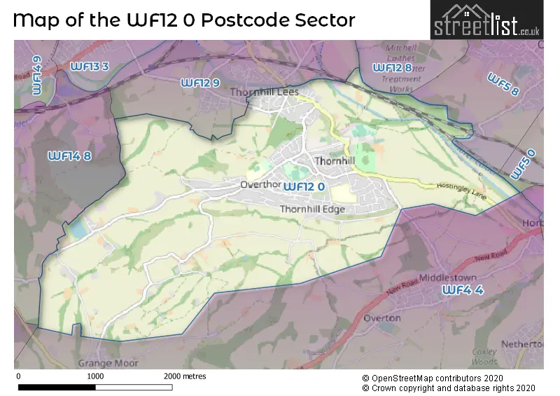
The WF12 0 Postcode shares a border with WF4 4 (Middlestown, Netherton, Flockton), WF5 0 (OSSETT), WF5 8 (OSSETT), WF12 8 (DEWSBURY, Earlsheaton, Chickenley), WF12 9 (DEWSBURY, Savile Town, Thornhill Lees), WF14 8 (MIRFIELD) and HD8 0 (Kirkburton, Lepton, Fenay Bridge).
Map of the WF12 0 Postcode Sector
Explore the WF12 0 postcode sector by using our interactive map.
The sector is within the post town of DEWSBURY.
WF12 0 is a postcode sector within the WF12 postcode district which is within the WF Wakefield postcode area.
The Royal Mail delivery office for the WF12 0 postal sector is the Calderway Delivery Office.
The area of the WF12 0 postcode sector is 4.64 square miles which is 12.01 square kilometres or 2,967.88 square acres.
Waterways within the WF12 0 postcode sector include the Calder & Hebble Navigation, River Calder.
Your support helps keep this site running!
If you enjoy using this website, consider buying me a coffee to help cover hosting costs.


| W | F | 1 | 2 | - | 0 | X | X |
| W | F | 1 | 2 | Space | 0 | Letter | Letter |
Official List of Streets
DEWSBURY (89 Streets)
(11 Streets)
Briestfield (4 Streets)
Whitley (6 Streets)
Thornhill (8 Streets)
Thornhill Lees (3 Streets)
Unofficial Streets or Alternative Spellings
DEWSBURY
BREWERY LANE LOCK STREET THE CROSSGrange Moor
SOWOOD LANEMiddlestown
HOSTINGLEY LANEOverton
WOOD LANEThornhill Lees
LONGCAUSEWAYMIRFIELD
CLOUGH LANEWeather Forecast for WF12 0
Weather Forecast for Thornhill Lees
| Time Period | Icon | Description | Temperature | Rain Probability | Wind |
|---|---|---|---|---|---|
| 21:00 to 00:00 | Cloudy | 8.0°C (feels like 5.0°C) | 5.00% | SSW 11 mph |
| Time Period | Icon | Description | Temperature | Rain Probability | Wind |
|---|---|---|---|---|---|
| 00:00 to 03:00 | Cloudy | 7.0°C (feels like 5.0°C) | 4.00% | S 7 mph | |
| 03:00 to 06:00 | Cloudy | 7.0°C (feels like 5.0°C) | 8.00% | SSE 7 mph | |
| 06:00 to 09:00 | Cloudy | 8.0°C (feels like 5.0°C) | 9.00% | SSE 9 mph | |
| 09:00 to 12:00 | Cloudy | 9.0°C (feels like 5.0°C) | 15.00% | SSW 16 mph | |
| 12:00 to 15:00 | Cloudy | 10.0°C (feels like 7.0°C) | 24.00% | SSW 16 mph | |
| 15:00 to 18:00 | Heavy rain | 10.0°C (feels like 7.0°C) | 83.00% | SSW 13 mph | |
| 18:00 to 21:00 | Clear night | 8.0°C (feels like 6.0°C) | 7.00% | SW 11 mph | |
| 21:00 to 00:00 | Clear night | 7.0°C (feels like 3.0°C) | 33.00% | WSW 13 mph |
| Time Period | Icon | Description | Temperature | Rain Probability | Wind |
|---|---|---|---|---|---|
| 00:00 to 03:00 | Clear night | 6.0°C (feels like 2.0°C) | 1.00% | WSW 11 mph | |
| 03:00 to 06:00 | Clear night | 5.0°C (feels like 2.0°C) | 7.00% | WSW 9 mph | |
| 06:00 to 09:00 | Clear night | 4.0°C (feels like 1.0°C) | 2.00% | WSW 9 mph | |
| 09:00 to 12:00 | Partly cloudy (day) | 5.0°C (feels like 2.0°C) | 2.00% | WSW 7 mph | |
| 12:00 to 15:00 | Cloudy | 7.0°C (feels like 5.0°C) | 4.00% | W 9 mph | |
| 15:00 to 18:00 | Sunny day | 8.0°C (feels like 5.0°C) | 1.00% | W 9 mph | |
| 18:00 to 21:00 | Clear night | 4.0°C (feels like 2.0°C) | 0.00% | W 7 mph | |
| 21:00 to 00:00 | Clear night | 2.0°C (feels like 0.0°C) | 0.00% | W 4 mph |
| Time Period | Icon | Description | Temperature | Rain Probability | Wind |
|---|---|---|---|---|---|
| 00:00 to 03:00 | Clear night | 1.0°C (feels like -1.0°C) | 0.00% | WNW 2 mph | |
| 03:00 to 06:00 | Clear night | 0.0°C (feels like -2.0°C) | 0.00% | W 2 mph | |
| 06:00 to 09:00 | Clear night | -1.0°C (feels like -3.0°C) | 3.00% | NW 2 mph | |
| 09:00 to 12:00 | Sunny day | 0.0°C (feels like -2.0°C) | 4.00% | NW 2 mph | |
| 12:00 to 15:00 | Sunny day | 5.0°C (feels like 4.0°C) | 1.00% | ENE 2 mph | |
| 15:00 to 18:00 | Sunny day | 7.0°C (feels like 5.0°C) | 1.00% | E 4 mph | |
| 18:00 to 21:00 | Clear night | 2.0°C (feels like 1.0°C) | 1.00% | ENE 4 mph | |
| 21:00 to 00:00 | Clear night | 1.0°C (feels like -1.0°C) | 1.00% | E 4 mph |
| Time Period | Icon | Description | Temperature | Rain Probability | Wind |
|---|---|---|---|---|---|
| 00:00 to 03:00 | Fog | 0.0°C (feels like -2.0°C) | 15.00% | NE 4 mph | |
| 03:00 to 06:00 | Fog | 0.0°C (feels like -2.0°C) | 17.00% | NNE 4 mph | |
| 06:00 to 09:00 | Fog | 0.0°C (feels like -2.0°C) | 17.00% | NNE 4 mph | |
| 09:00 to 12:00 | Fog | 1.0°C (feels like -1.0°C) | 16.00% | NNE 4 mph | |
| 12:00 to 15:00 | Cloudy | 4.0°C (feels like 2.0°C) | 6.00% | NE 7 mph | |
| 15:00 to 18:00 | Partly cloudy (day) | 5.0°C (feels like 3.0°C) | 2.00% | ENE 7 mph | |
| 18:00 to 21:00 | Clear night | 3.0°C (feels like 0.0°C) | 2.00% | NE 4 mph | |
| 21:00 to 00:00 | Overcast | 1.0°C (feels like -1.0°C) | 8.00% | NE 4 mph |
Schools and Places of Education Within the WF12 0 Postcode Sector
Overthorpe CofE Academy
Academy sponsor led
Edge Top Road, Dewsbury, West Yorkshire, WF12 0BH
Head: Mr Joe Mitchell
Ofsted Rating: Good
Inspection: 2019-01-30 (2196 days ago)
Website: Visit Overthorpe CofE Academy Website
Phone: 01924325300
Number of Pupils: 267
Thornhill Community Academy, A Share Academy
Academy converter
Valley Drive, Dewsbury, , WF12 0HE
Head: Mr Matthew Burton
Ofsted Rating: Good
Inspection: 2023-02-23 (711 days ago)
Website: Visit Thornhill Community Academy, A Share Academy Website
Phone:
Number of Pupils: 886
Thornhill Junior and Infant School
Academy converter
Edge Lane, Dewsbury, West Yorkshire, WF12 0QT
Head: Ms Jennifer Rylance
Ofsted Rating: Good
Inspection: 2019-05-02 (2104 days ago)
Website: Visit Thornhill Junior and Infant School Website
Phone: 01924453259
Number of Pupils: 362
House Prices in the WF12 0 Postcode Sector
| Type of Property | 2018 Average | 2018 Sales | 2017 Average | 2017 Sales | 2016 Average | 2016 Sales | 2015 Average | 2015 Sales |
|---|---|---|---|---|---|---|---|---|
| Detached | £260,511 | 46 | £269,988 | 49 | £269,710 | 48 | £251,455 | 45 |
| Semi-Detached | £148,903 | 32 | £121,250 | 38 | £117,374 | 36 | £114,218 | 30 |
| Terraced | £99,752 | 37 | £104,541 | 39 | £104,662 | 55 | £96,429 | 35 |
| Flats | £0 | 0 | £122,333 | 3 | £69,500 | 2 | £47,000 | 1 |
Important Postcodes WF12 0 in the Postcode Sector
WF12 0BH is the postcode for JUNIOR BLOCK, Overthorpe CE Academy, Edge Top Road, Overthorpe CE Academy, Edge Top Road, INFANTS & CHILDRENS CENTRE, Overthorpe CE Academy, Edge Top Road, and Overthorpe CE (C) Junior Infant & Nursery School, Edge Top Road
WF12 0HE is the postcode for THORNHILL COMMUNITY ACADEMY, VALLEY DRIVE, THORNHILL, Thornhill Community Academy, Valley Drive, and Thornhill High School, Valley Drive
WF12 0QT is the postcode for Thornhill Junior & Infant School, Edge Lane
WF12 0SH is the postcode for BUILDING SERVICES THORNHILL DEPOT, Kirklees Metropolitan Council, The Combs
| The WF12 0 Sector is within these Local Authorities |
|
|---|---|
| The WF12 0 Sector is within these Counties |
|
| The WF12 0 Sector is within these Water Company Areas |
|