A wide range of spatial data has been analysed to present this overview of the WF11 9 Postcode sector. If you would like anything added, please contact us.
The WF11 9 postcode sector stands on the North Yorkshire and West Yorkshire border.
Did you know? According to the 2021 Census, the WF11 9 postcode sector is home to a bustling 4,309 residents!
Given that each sector allows for 400 unique postcode combinations. Letters C, I, K, M, O and V are not allowed in the last two letters of a postcode. With 152 postcodes already in use, this leaves 248 units available.
The largest settlement in the WF11 9 postal code is KNOTTINGLEY followed by Byram, and Brotherton.
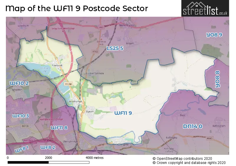
The WF11 9 Postcode shares a border with LS25 5 (South Milford, Monk Fryston, Hillam), WF10 2 (Allerton Bywater, CASTLEFORD, Ledston), WF11 8 (KNOTTINGLEY, Ferrybridge), YO8 8 (SELBY, Camblesforth, Barlow), YO8 9 (Thorpe Willoughby, Brayton, SELBY) and DN14 0 (Eggborough, Whitley, Hensall).
Map of the WF11 9 Postcode Sector
Explore the WF11 9 postcode sector by using our interactive map.
The sector is within the post town of KNOTTINGLEY.
WF11 9 is a postcode sector within the WF11 postcode district which is within the WF Wakefield postcode area.
The Royal Mail delivery office for the WF11 9 postal sector is the Pontefract Delivery Office.
The area of the WF11 9 postcode sector is 8.97 square miles which is 23.24 square kilometres or 5,743.94 square acres.
The WF11 9 postcode sector is crossed by the A1M Major A road.
Waterways within the WF11 9 postcode sector include the Aire & Calder Navigation, River Aire.
Your support helps keep this site running!
If you enjoy using this website, consider buying me a coffee to help cover hosting costs.


| W | F | 1 | 1 | - | 9 | X | X |
| W | F | 1 | 1 | Space | 9 | Letter | Letter |
Official List of Streets
KNOTTINGLEY (34 Streets)
Brotherton (30 Streets)
Fairburn (29 Streets)
(16 Streets)
Birkin (4 Streets)
Byram (19 Streets)
Sutton (2 Streets)
Unofficial Streets or Alternative Spellings
Beal
WEELAND ROADKNOTTINGLEY
GLEBE LANE RACCA GREEN STOCKING LANESouth Milford
HOLYROOD LANE LONDON ROAD DISH HILL FLYOVER FERRY BRIDGE FERRYBRIDGE BY-PASS FERRYBRIDGE BYPASS LUNNFIELD LANE LUNNFIELDS LANE RIVERSIDE COURT ROPE WALK TAPPERS GARDENS THE PADDOCKFairburn
CLIFF HILL TERRACE LOW HOLLANDAberford
GREAT NORTH ROADAllerton Bywater
NEWTON LANEWeather Forecast for WF11 9
Weather Forecast for Knottingley
| Time Period | Icon | Description | Temperature | Rain Probability | Wind |
|---|---|---|---|---|---|
| 12:00 to 15:00 | Overcast | 6.0°C (feels like 3.0°C) | 8.00% | S 9 mph | |
| 15:00 to 18:00 | Overcast | 6.0°C (feels like 4.0°C) | 9.00% | S 9 mph | |
| 18:00 to 21:00 | Overcast | 5.0°C (feels like 3.0°C) | 9.00% | SSE 9 mph | |
| 21:00 to 00:00 | Cloudy | 5.0°C (feels like 2.0°C) | 9.00% | SSE 9 mph |
| Time Period | Icon | Description | Temperature | Rain Probability | Wind |
|---|---|---|---|---|---|
| 00:00 to 03:00 | Overcast | 4.0°C (feels like 1.0°C) | 9.00% | S 11 mph | |
| 03:00 to 06:00 | Overcast | 3.0°C (feels like 0.0°C) | 8.00% | S 9 mph | |
| 06:00 to 09:00 | Cloudy | 3.0°C (feels like -1.0°C) | 8.00% | SSE 9 mph | |
| 09:00 to 12:00 | Partly cloudy (day) | 3.0°C (feels like -1.0°C) | 4.00% | S 9 mph | |
| 12:00 to 15:00 | Cloudy | 5.0°C (feels like 2.0°C) | 6.00% | S 9 mph | |
| 15:00 to 18:00 | Cloudy | 7.0°C (feels like 4.0°C) | 5.00% | SSW 7 mph | |
| 18:00 to 21:00 | Cloudy | 5.0°C (feels like 3.0°C) | 5.00% | SSW 7 mph | |
| 21:00 to 00:00 | Partly cloudy (night) | 4.0°C (feels like 1.0°C) | 1.00% | SSW 7 mph |
| Time Period | Icon | Description | Temperature | Rain Probability | Wind |
|---|---|---|---|---|---|
| 00:00 to 03:00 | Partly cloudy (night) | 4.0°C (feels like 1.0°C) | 1.00% | SSW 7 mph | |
| 03:00 to 06:00 | Cloudy | 4.0°C (feels like 1.0°C) | 4.00% | SSW 7 mph | |
| 06:00 to 09:00 | Cloudy | 3.0°C (feels like 0.0°C) | 5.00% | SSW 7 mph | |
| 09:00 to 12:00 | Cloudy | 4.0°C (feels like 1.0°C) | 5.00% | SSW 9 mph | |
| 12:00 to 15:00 | Cloudy | 7.0°C (feels like 4.0°C) | 4.00% | SSW 9 mph | |
| 15:00 to 18:00 | Partly cloudy (day) | 8.0°C (feels like 6.0°C) | 2.00% | SSW 11 mph | |
| 18:00 to 21:00 | Cloudy | 7.0°C (feels like 4.0°C) | 5.00% | S 11 mph | |
| 21:00 to 00:00 | Partly cloudy (night) | 7.0°C (feels like 3.0°C) | 2.00% | SSW 11 mph |
| Time Period | Icon | Description | Temperature | Rain Probability | Wind |
|---|---|---|---|---|---|
| 00:00 to 03:00 | Cloudy | 6.0°C (feels like 3.0°C) | 7.00% | S 11 mph | |
| 03:00 to 06:00 | Cloudy | 7.0°C (feels like 4.0°C) | 12.00% | SSW 11 mph | |
| 06:00 to 09:00 | Cloudy | 7.0°C (feels like 4.0°C) | 13.00% | SSW 11 mph | |
| 09:00 to 12:00 | Cloudy | 8.0°C (feels like 5.0°C) | 13.00% | SSW 11 mph | |
| 12:00 to 15:00 | Cloudy | 9.0°C (feels like 7.0°C) | 14.00% | SSW 13 mph | |
| 15:00 to 18:00 | Cloudy | 10.0°C (feels like 7.0°C) | 11.00% | SW 11 mph | |
| 18:00 to 21:00 | Partly cloudy (night) | 8.0°C (feels like 5.0°C) | 9.00% | SW 9 mph | |
| 21:00 to 00:00 | Partly cloudy (night) | 7.0°C (feels like 4.0°C) | 3.00% | WSW 9 mph |
Schools and Places of Education Within the WF11 9 Postcode Sector
Brotherton and Byram Community Primary Academy
Academy sponsor led
Low Street, Knottingley, West Yorkshire, WF11 9HQ
Head: Mr Ben Greene
Ofsted Rating: Good
Inspection: 2023-10-19 (471 days ago)
Website: Visit Brotherton and Byram Community Primary Academy Website
Phone: 01977355020
Number of Pupils: 188
Fairburn Community Primary School
Community school
Great North Road, Knottingley, West Yorkshire, WF11 9JY
Head: Emma Cornhill
Ofsted Rating: Outstanding
Inspection: 2015-02-13 (3641 days ago)
Website: Visit Fairburn Community Primary School Website
Phone: 01977672158
Number of Pupils: 88
St Botolphs CE Academy
Academy converter
Primrose Vale, Knottingley, West Yorkshire, WF11 9BT
Head: Mrs Louise Sennett
Ofsted Rating: Requires improvement
Inspection: 2022-07-06 (941 days ago)
Website: Visit St Botolphs CE Academy Website
Phone: 01977677494
Number of Pupils: 330
House Prices in the WF11 9 Postcode Sector
| Type of Property | 2018 Average | 2018 Sales | 2017 Average | 2017 Sales | 2016 Average | 2016 Sales | 2015 Average | 2015 Sales |
|---|---|---|---|---|---|---|---|---|
| Detached | £258,591 | 22 | £279,066 | 22 | £222,319 | 29 | £248,417 | 27 |
| Semi-Detached | £132,305 | 22 | £143,295 | 22 | £128,921 | 28 | £131,119 | 21 |
| Terraced | £93,346 | 13 | £109,622 | 16 | £112,571 | 7 | £107,221 | 14 |
| Flats | £94,000 | 2 | £92,500 | 3 | £116,500 | 2 | £76,125 | 4 |
Important Postcodes WF11 9 in the Postcode Sector
WF11 9BT is the postcode for Knottingley St Botolps CE Academy, Primrose Vale, and Knottingley St Boltophs C Of E Academy, Primrose Vale
WF11 9HQ is the postcode for MAIN BUILDING, Brotherton & Byram C P Academy, Low Street, Brotherton & Byram Childrens Centre, Low Street, Brotherton & Byram C P Academy, Low Street, and Main Building, Brotherton & Byram C P School, Low Street
WF11 9JY is the postcode for MAIN BUILDING, Fairburn Cp School, Great North Road
| The WF11 9 Sector is within these Local Authorities |
|
|---|---|
| The WF11 9 Sector is within these Counties |
|
| The WF11 9 Sector is within these Water Company Areas |
|