A wide range of spatial data has been analysed to present this overview of the WD19 6 Postcode sector. If you would like anything added, please contact us.
The WD19 6 postcode sector stands on the Greater London and Hertfordshire border.
Did you know? According to the 2021 Census, the WD19 6 postcode sector is home to a bustling 7,747 residents!
Given that each sector allows for 400 unique postcode combinations. Letters C, I, K, M, O and V are not allowed in the last two letters of a postcode. With 181 postcodes already in use, this leaves 219 units available.
The WD19 6 postal code covers the settlement of SOUTH OXHEY .
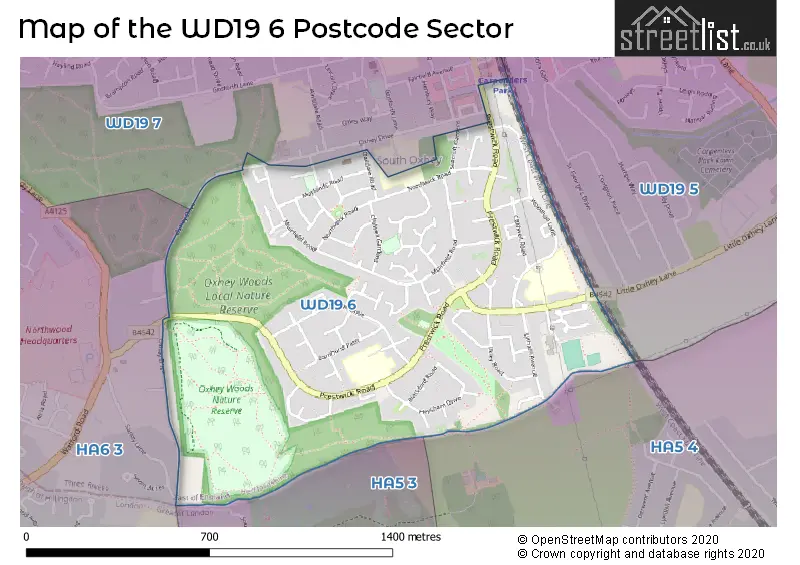
The WD19 6 Postcode shares a border with WD19 5 (CARPENDERS PARK ), WD19 7 (SOUTH OXHEY ), HA5 3 (PINNER , NORTHWOOD , HATCH END ), HA5 4 (PINNER , HATCH END ) and HA6 3 (NORTHWOOD ).
Map of the WD19 6 Postcode Sector
Explore the WD19 6 postcode sector by using our interactive map.
The sector is within the post town of WATFORD.
WD19 6 is a postcode sector within the WD19 postcode district which is within the WD Watford postcode area.
The Royal Mail delivery office for the WD19 6 postal sector is the Watford (wd) Delivery Office.
The area of the WD19 6 postcode sector is 0.69 square miles which is 1.78 square kilometres or 440.66 square acres.
Your support helps keep this site running!
If you enjoy using this website, consider buying me a coffee to help cover hosting costs.


| W | D | 1 | 9 | - | 6 | X | X |
| W | D | 1 | 9 | Space | 6 | Letter | Letter |
Official List of Streets
WATFORD (78 Streets)
(1 Streets)
Unofficial Streets or Alternative Spellings
NORTHWOOD,
OXHEY DRIVEPINNER
POTTER STREET HILLNORTHWOOD
THE WOODS WOODSIDE WALKWeather Forecast for WD19 6
Weather Forecast for Northwood
| Time Period | Icon | Description | Temperature | Rain Probability | Wind |
|---|---|---|---|---|---|
| 03:00 to 06:00 | Overcast | 7.0°C (feels like 5.0°C) | 10.00% | SW 9 mph | |
| 06:00 to 09:00 | Cloudy | 8.0°C (feels like 5.0°C) | 7.00% | SW 11 mph | |
| 09:00 to 12:00 | Overcast | 8.0°C (feels like 5.0°C) | 9.00% | SSW 13 mph | |
| 12:00 to 15:00 | Overcast | 9.0°C (feels like 6.0°C) | 9.00% | SW 18 mph | |
| 15:00 to 18:00 | Cloudy | 10.0°C (feels like 7.0°C) | 9.00% | SW 18 mph | |
| 18:00 to 21:00 | Cloudy | 10.0°C (feels like 6.0°C) | 9.00% | SW 20 mph | |
| 21:00 to 00:00 | Overcast | 10.0°C (feels like 7.0°C) | 16.00% | SW 20 mph |
| Time Period | Icon | Description | Temperature | Rain Probability | Wind |
|---|---|---|---|---|---|
| 00:00 to 03:00 | Overcast | 10.0°C (feels like 7.0°C) | 18.00% | SW 20 mph | |
| 03:00 to 06:00 | Cloudy | 10.0°C (feels like 7.0°C) | 19.00% | SW 18 mph | |
| 06:00 to 09:00 | Overcast | 10.0°C (feels like 7.0°C) | 21.00% | SW 16 mph | |
| 09:00 to 12:00 | Overcast | 10.0°C (feels like 7.0°C) | 24.00% | SW 13 mph | |
| 12:00 to 15:00 | Heavy rain | 10.0°C (feels like 7.0°C) | 80.00% | SW 18 mph | |
| 15:00 to 18:00 | Heavy rain | 10.0°C (feels like 6.0°C) | 89.00% | SW 20 mph | |
| 18:00 to 21:00 | Heavy rain | 9.0°C (feels like 5.0°C) | 88.00% | WSW 18 mph | |
| 21:00 to 00:00 | Light rain | 7.0°C (feels like 3.0°C) | 55.00% | WNW 13 mph |
| Time Period | Icon | Description | Temperature | Rain Probability | Wind |
|---|---|---|---|---|---|
| 00:00 to 03:00 | Cloudy | 4.0°C (feels like 1.0°C) | 22.00% | NW 11 mph | |
| 03:00 to 06:00 | Cloudy | 3.0°C (feels like 0.0°C) | 14.00% | NW 9 mph | |
| 06:00 to 09:00 | Cloudy | 2.0°C (feels like -1.0°C) | 7.00% | NNW 7 mph | |
| 09:00 to 12:00 | Partly cloudy (day) | 1.0°C (feels like -2.0°C) | 2.00% | NNW 7 mph | |
| 12:00 to 15:00 | Sunny day | 3.0°C (feels like 0.0°C) | 1.00% | NNW 7 mph | |
| 15:00 to 18:00 | Sunny day | 3.0°C (feels like 0.0°C) | 3.00% | NNW 7 mph | |
| 18:00 to 21:00 | Clear night | 1.0°C (feels like -2.0°C) | 3.00% | NNW 7 mph | |
| 21:00 to 00:00 | Clear night | 0.0°C (feels like -3.0°C) | 2.00% | NNW 7 mph |
| Time Period | Icon | Description | Temperature | Rain Probability | Wind |
|---|---|---|---|---|---|
| 00:00 to 03:00 | Clear night | -1.0°C (feels like -4.0°C) | 1.00% | NNW 7 mph | |
| 03:00 to 06:00 | Clear night | -1.0°C (feels like -4.0°C) | 1.00% | NNW 4 mph | |
| 06:00 to 09:00 | Clear night | -2.0°C (feels like -5.0°C) | 1.00% | NNW 4 mph | |
| 09:00 to 12:00 | Sunny day | -2.0°C (feels like -5.0°C) | 1.00% | NW 4 mph | |
| 12:00 to 15:00 | Sunny day | 1.0°C (feels like -1.0°C) | 1.00% | WNW 4 mph | |
| 15:00 to 18:00 | Sunny day | 2.0°C (feels like 0.0°C) | 1.00% | WNW 4 mph | |
| 18:00 to 21:00 | Clear night | 0.0°C (feels like -3.0°C) | 1.00% | W 7 mph | |
| 21:00 to 00:00 | Clear night | -1.0°C (feels like -3.0°C) | 2.00% | W 4 mph |
Schools and Places of Education Within the WD19 6 Postcode Sector
Greenfields Primary School
Community school
Ellesborough Close, Watford, Hertfordshire, WD19 6QH
Head: Mrs Kate Day
Ofsted Rating: Good
Inspection: 2022-04-28 (978 days ago)
Website: Visit Greenfields Primary School Website
Phone: 02084281166
Number of Pupils: 201
Woodhall Primary School
Community school
Woodhall Lane, Watford, Hertfordshire, WD19 6QX
Head: Miss Michelle Lake
Ofsted Rating: Good
Inspection: 2022-11-09 (783 days ago)
Website: Visit Woodhall Primary School Website
Phone: 02084283447
Number of Pupils: 125
House Prices in the WD19 6 Postcode Sector
| Type of Property | 2018 Average | 2018 Sales | 2017 Average | 2017 Sales | 2016 Average | 2016 Sales | 2015 Average | 2015 Sales |
|---|---|---|---|---|---|---|---|---|
| Detached | £0 | 0 | £450,000 | 3 | £385,000 | 1 | £0 | 0 |
| Semi-Detached | £358,511 | 38 | £371,605 | 28 | £362,627 | 26 | £314,614 | 35 |
| Terraced | £354,733 | 36 | £343,009 | 43 | £342,717 | 38 | £303,652 | 45 |
| Flats | £231,994 | 9 | £243,192 | 13 | £234,564 | 7 | £192,192 | 13 |
Important Postcodes WD19 6 in the Postcode Sector
WD19 6FW is the postcode for Sir James Altham Sports Facility, Little Oxhey Lane
WD19 6QH is the postcode for Greenfields Primary School, Ellesborough Close, and GREENFIELD PRIMARY SCHOOL, ELLESBOROUGH CLOSE, SOUTH OXHEY
WD19 6QX is the postcode for Woodhall School, Woodhall Lane
| The WD19 6 Sector is within these Local Authorities |
|
|---|---|
| The WD19 6 Sector is within these Counties |
|
| The WD19 6 Sector is within these Water Company Areas |
|