A wide range of spatial data has been analysed to present this overview of the WC2A 3 Postcode sector. If you would like anything added, please contact us.
The WC2A 3 postcode sector stands on the Greater London and City and County of the City of London border.
Did you know? According to the 2021 Census, the WC2A 3 postcode sector is home to a bustling 80 residents!
Given that each sector allows for 400 unique postcode combinations. Letters C, I, K, M, O and V are not allowed in the last two letters of a postcode. With 63 postcodes already in use, this leaves 337 units available.
The WC2A 3 postal code covers the settlement of LONDON .
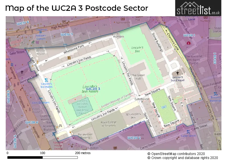
The WC2A 3 Postcode shares a border with WC1V 7 (LONDON ), WC2A 2 (LONDON ), WC2A 1 (LONDON ) and WC2B 6 (LONDON ).
Map of the WC2A 3 Postcode Sector
Explore the WC2A 3 postcode sector by using our interactive map.
The sector is within the post town of LONDON.
WC2A 3 is a postcode sector within the WC2A postcode district which is within the WC West Central London postcode area.
The Royal Mail delivery office for the WC2A 3 postal sector is the unknown.
The area of the WC2A 3 postcode sector is 0.05 square miles which is 0.12 square kilometres or 29.70 square acres.
Your support helps keep this site running!
If you enjoy using this website, consider buying me a coffee to help cover hosting costs.


| W | C | 2 | A | - | 3 | X | X |
| W | C | 2 | A | Space | 3 | Letter | Letter |
Official List of Streets
(8 Streets)
Camden (9 Streets)
Unofficial Streets or Alternative Spellings
City of London
QUALITY COURT SOUTHAMPTON BUILDINGSCamden
CAREY STREET CHANCERY LANE CHICHESTER RENTS GREAT TURNSTILE LITTLE TURNSTILE HARDWICKE BUILDING STAR YARDWestminster
PORTSMOUTH STREET PORTUGAL STREETWeather Forecast for WC2A 3
Weather Forecast for London
| Time Period | Icon | Description | Temperature | Rain Probability | Wind |
|---|---|---|---|---|---|
| 21:00 to 00:00 | Cloudy | 6.0°C (feels like 2.0°C) | 5.00% | WNW 18 mph |
| Time Period | Icon | Description | Temperature | Rain Probability | Wind |
|---|---|---|---|---|---|
| 00:00 to 03:00 | Clear night | 6.0°C (feels like 2.0°C) | 0.00% | NW 16 mph | |
| 03:00 to 06:00 | Clear night | 5.0°C (feels like 1.0°C) | 0.00% | NW 13 mph | |
| 06:00 to 09:00 | Clear night | 5.0°C (feels like 1.0°C) | 0.00% | NW 11 mph | |
| 09:00 to 12:00 | Sunny day | 4.0°C (feels like 1.0°C) | 0.00% | NW 11 mph | |
| 12:00 to 15:00 | Sunny day | 6.0°C (feels like 3.0°C) | 0.00% | NW 9 mph | |
| 15:00 to 18:00 | Cloudy | 7.0°C (feels like 4.0°C) | 4.00% | WNW 9 mph | |
| 18:00 to 21:00 | Cloudy | 6.0°C (feels like 4.0°C) | 5.00% | W 7 mph | |
| 21:00 to 00:00 | Cloudy | 6.0°C (feels like 4.0°C) | 20.00% | WSW 4 mph |
| Time Period | Icon | Description | Temperature | Rain Probability | Wind |
|---|---|---|---|---|---|
| 00:00 to 03:00 | Light rain | 6.0°C (feels like 4.0°C) | 52.00% | SW 4 mph | |
| 03:00 to 06:00 | Overcast | 7.0°C (feels like 5.0°C) | 50.00% | SW 4 mph | |
| 06:00 to 09:00 | Overcast | 7.0°C (feels like 6.0°C) | 13.00% | WSW 4 mph | |
| 09:00 to 12:00 | Overcast | 8.0°C (feels like 7.0°C) | 12.00% | WSW 4 mph | |
| 12:00 to 15:00 | Overcast | 10.0°C (feels like 9.0°C) | 10.00% | WSW 4 mph | |
| 15:00 to 18:00 | Overcast | 11.0°C (feels like 10.0°C) | 10.00% | WSW 4 mph | |
| 18:00 to 21:00 | Overcast | 11.0°C (feels like 10.0°C) | 11.00% | WSW 4 mph | |
| 21:00 to 00:00 | Overcast | 11.0°C (feels like 9.0°C) | 13.00% | WSW 4 mph |
| Time Period | Icon | Description | Temperature | Rain Probability | Wind |
|---|---|---|---|---|---|
| 00:00 to 03:00 | Overcast | 10.0°C (feels like 9.0°C) | 12.00% | WSW 4 mph | |
| 03:00 to 06:00 | Overcast | 10.0°C (feels like 8.0°C) | 12.00% | WSW 4 mph | |
| 06:00 to 09:00 | Overcast | 9.0°C (feels like 8.0°C) | 14.00% | WSW 4 mph | |
| 09:00 to 12:00 | Overcast | 9.0°C (feels like 8.0°C) | 13.00% | WSW 4 mph | |
| 12:00 to 15:00 | Overcast | 10.0°C (feels like 9.0°C) | 14.00% | WSW 4 mph | |
| 15:00 to 18:00 | Overcast | 11.0°C (feels like 10.0°C) | 11.00% | WSW 4 mph | |
| 18:00 to 21:00 | Overcast | 10.0°C (feels like 9.0°C) | 11.00% | WSW 2 mph | |
| 21:00 to 00:00 | Overcast | 9.0°C (feels like 9.0°C) | 11.00% | SW 2 mph |
| Time Period | Icon | Description | Temperature | Rain Probability | Wind |
|---|---|---|---|---|---|
| 00:00 to 03:00 | Overcast | 9.0°C (feels like 8.0°C) | 12.00% | SW 2 mph | |
| 03:00 to 06:00 | Overcast | 8.0°C (feels like 8.0°C) | 12.00% | WSW 2 mph | |
| 06:00 to 09:00 | Overcast | 8.0°C (feels like 8.0°C) | 12.00% | SSW 2 mph | |
| 09:00 to 12:00 | Overcast | 8.0°C (feels like 7.0°C) | 14.00% | SSE 2 mph | |
| 12:00 to 15:00 | Overcast | 9.0°C (feels like 8.0°C) | 13.00% | SW 2 mph | |
| 15:00 to 18:00 | Overcast | 9.0°C (feels like 9.0°C) | 11.00% | SSE 2 mph | |
| 18:00 to 21:00 | Overcast | 8.0°C (feels like 8.0°C) | 10.00% | E 2 mph | |
| 21:00 to 00:00 | Overcast | 8.0°C (feels like 7.0°C) | 11.00% | WSW 2 mph |
House Prices in the WC2A 3 Postcode Sector
| Type of Property | 2018 Average | 2018 Sales | 2017 Average | 2017 Sales | 2016 Average | 2016 Sales | 2015 Average | 2015 Sales |
|---|---|---|---|---|---|---|---|---|
| Detached | £0 | 0 | £0 | 0 | £0 | 0 | £0 | 0 |
| Semi-Detached | £0 | 0 | £0 | 0 | £0 | 0 | £0 | 0 |
| Terraced | £0 | 0 | £0 | 0 | £11,550,000 | 1 | £0 | 0 |
| Flats | £2,825,000 | 1 | £1,108,571 | 7 | £0 | 0 | £0 | 0 |
Important Postcodes WC2A 3 in the Postcode Sector
WC2A 3JB is the postcode for Centre for Commercial Law, Northgate House, 67-69 Lincoln's Inn Fields, and FIFTH FLOOR 67-69 LINCOLN'S INN FIELDS, 67-69 Lincoln's Inn Fields
WC2A 3LZ is the postcode for Sardinia House, 51-52 Lincoln's Inn Fields
WC2A 3PE is the postcode for Royal College of Surgeons of England, New Nuffield Building, 35-37 Lincoln's Inn Fields, Royal College of Surgeons of England, 35-43 Lincoln's Inn Fields, and Royal College of Surgeons of England, New Nuffield Building
WC2A 3PF is the postcode for London School of Economics, 50 Lincoln's Inn Fields
WC2A 3PH is the postcode for 32 Lincoln's Inn Fields, Sir Arthur Lewis Building, 32 Lincoln's Inn Fields, and H M Land Registry, 32 Lincoln's Inn Fields
WC2A 3TD is the postcode for Territorial Army, 10 Stone Buildings
| The WC2A 3 Sector is within these Local Authorities |
|
|---|---|
| The WC2A 3 Sector is within these Counties |
|
| The WC2A 3 Sector is within these Water Company Areas |
|
Tourist Attractions within the WC2A 3 Postcode Area
We found 1 visitor attractions within the WC2A postcode area
| Sir John Soane's Museum |
|---|
| Museums & Art Galleries |
| Museum and / or Art Gallery |
| View Sir John Soane's Museum on Google Maps |