A wide range of spatial data has been analysed to present this overview of the WA4 2 Postcode sector. If you would like anything added, please contact us.
The WA4 2 postcode sector is within the county of Cheshire.
Did you know? According to the 2021 Census, the WA4 2 postcode sector is home to a bustling 13,307 residents!
Given that each sector allows for 400 unique postcode combinations. Letters C, I, K, M, O and V are not allowed in the last two letters of a postcode. With 286 postcodes already in use, this leaves 114 units available.
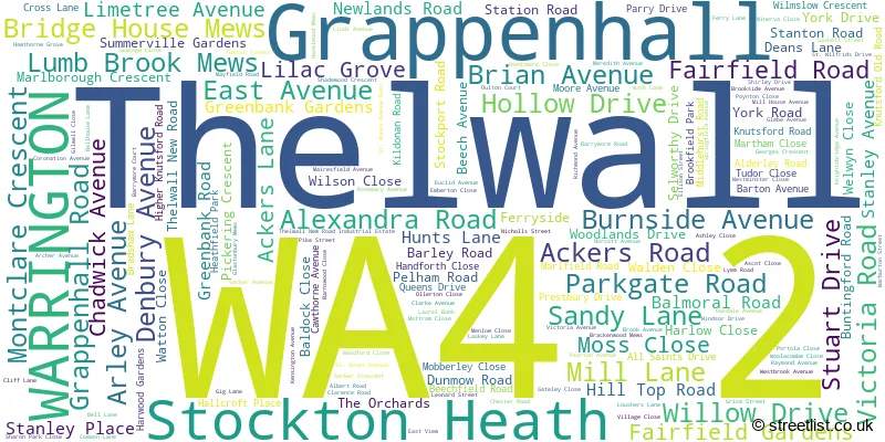
The largest settlement in the WA4 2 postal code is Grappenhall followed by Stockton Heath, and Thelwall.
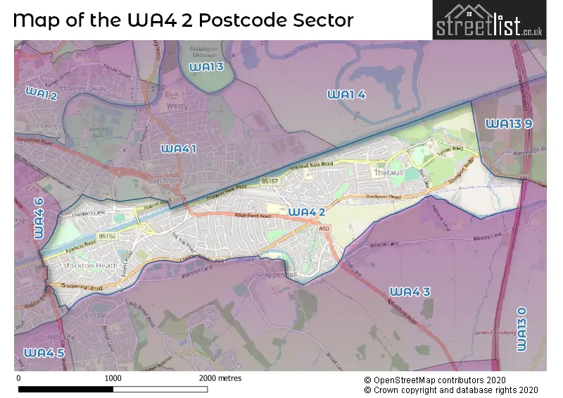
The WA4 2 Postcode shares a border with WA13 0 (LYMM), WA1 4 (Woolston, Padgate), WA4 1 (WARRINGTON, Latchford), WA4 3 (Appleton, Grappenhall, WARRINGTON), WA4 6 (WARRINGTON, Stockton Heath, Moore) and WA13 9 (LYMM, Warburton).
Map of the WA4 2 Postcode Sector
Explore the WA4 2 postcode sector by using our interactive map.
The sector is within the post town of WARRINGTON.
WA4 2 is a postcode sector within the WA4 postcode district which is within the WA Warrington postcode area.
The Royal Mail delivery office for the WA4 2 postal sector is the Warrington Delivery Office.
The area of the WA4 2 postcode sector is 1.71 square miles which is 4.42 square kilometres or 1,092.07 square acres.
The WA4 2 postcode sector is crossed by the M6 motorway.
Waterways within the WA4 2 postcode sector include the Manchester Ship Canal, Bridgewater Canal.
Your support helps keep this site running!
If you enjoy using this website, consider buying me a coffee to help cover hosting costs.

| W | A | 4 | - | 2 | X | X |
| W | A | 4 | Space | 2 | Letter | Letter |
Official List of Streets
Stockton Heath (52 Streets)
(8 Streets)
Grappenhall (67 Streets)
Thelwall (35 Streets)
WARRINGTON (16 Streets)
Unofficial Streets or Alternative Spellings
Grappenhall
CANAL SIDE CHURCH LANEStockton Heath
ELLESMERE ROAD WALTON ROAD WEST AVENUEWARRINGTON
GRAMMAR SCHOOL ROAD KNUTSFORD ROAD WILDERSPOOL CAUSEWAYLatchford
STATION ROADAppleton
LONDON ROADAppleton Thorn
LUMB BROOK ROADWeather Forecast for WA4 2
Weather Forecast for Warrington
| Time Period | Icon | Description | Temperature | Rain Probability | Wind |
|---|---|---|---|---|---|
| 09:00 to 12:00 | Cloudy | 5.0°C (feels like 2.0°C) | 6.00% | SSE 9 mph | |
| 12:00 to 15:00 | Overcast | 6.0°C (feels like 4.0°C) | 9.00% | S 9 mph | |
| 15:00 to 18:00 | Overcast | 7.0°C (feels like 6.0°C) | 12.00% | S 7 mph | |
| 18:00 to 21:00 | Overcast | 7.0°C (feels like 5.0°C) | 11.00% | S 7 mph | |
| 21:00 to 00:00 | Cloudy | 6.0°C (feels like 4.0°C) | 5.00% | S 7 mph |
| Time Period | Icon | Description | Temperature | Rain Probability | Wind |
|---|---|---|---|---|---|
| 00:00 to 03:00 | Overcast | 6.0°C (feels like 4.0°C) | 9.00% | S 4 mph | |
| 03:00 to 06:00 | Cloudy | 5.0°C (feels like 3.0°C) | 4.00% | S 4 mph | |
| 06:00 to 09:00 | Cloudy | 4.0°C (feels like 1.0°C) | 4.00% | S 7 mph | |
| 09:00 to 12:00 | Cloudy | 4.0°C (feels like 1.0°C) | 4.00% | SSE 7 mph | |
| 12:00 to 15:00 | Cloudy | 8.0°C (feels like 5.0°C) | 4.00% | S 9 mph | |
| 15:00 to 18:00 | Cloudy | 10.0°C (feels like 7.0°C) | 4.00% | S 9 mph | |
| 18:00 to 21:00 | Cloudy | 8.0°C (feels like 5.0°C) | 4.00% | S 9 mph | |
| 21:00 to 00:00 | Cloudy | 7.0°C (feels like 4.0°C) | 5.00% | S 11 mph |
| Time Period | Icon | Description | Temperature | Rain Probability | Wind |
|---|---|---|---|---|---|
| 00:00 to 03:00 | Cloudy | 7.0°C (feels like 4.0°C) | 5.00% | S 11 mph | |
| 03:00 to 06:00 | Overcast | 7.0°C (feels like 4.0°C) | 8.00% | S 11 mph | |
| 06:00 to 09:00 | Cloudy | 8.0°C (feels like 5.0°C) | 7.00% | S 11 mph | |
| 09:00 to 12:00 | Cloudy | 8.0°C (feels like 5.0°C) | 15.00% | S 11 mph | |
| 12:00 to 15:00 | Cloudy | 10.0°C (feels like 7.0°C) | 22.00% | SSW 13 mph | |
| 15:00 to 18:00 | Light rain shower (day) | 10.0°C (feels like 7.0°C) | 39.00% | SW 11 mph | |
| 18:00 to 21:00 | Clear night | 8.0°C (feels like 6.0°C) | 11.00% | SW 11 mph | |
| 21:00 to 00:00 | Clear night | 7.0°C (feels like 4.0°C) | 5.00% | WSW 11 mph |
| Time Period | Icon | Description | Temperature | Rain Probability | Wind |
|---|---|---|---|---|---|
| 00:00 to 03:00 | Clear night | 6.0°C (feels like 3.0°C) | 2.00% | W 11 mph | |
| 03:00 to 06:00 | Clear night | 5.0°C (feels like 2.0°C) | 2.00% | W 9 mph | |
| 06:00 to 09:00 | Clear night | 4.0°C (feels like 1.0°C) | 2.00% | WSW 7 mph | |
| 09:00 to 12:00 | Cloudy | 4.0°C (feels like 2.0°C) | 4.00% | WSW 4 mph | |
| 12:00 to 15:00 | Cloudy | 7.0°C (feels like 6.0°C) | 4.00% | WSW 7 mph | |
| 15:00 to 18:00 | Partly cloudy (day) | 8.0°C (feels like 7.0°C) | 2.00% | W 7 mph | |
| 18:00 to 21:00 | Clear night | 5.0°C (feels like 3.0°C) | 1.00% | SSE 4 mph | |
| 21:00 to 00:00 | Clear night | 3.0°C (feels like 2.0°C) | 1.00% | SSE 4 mph |
Schools and Places of Education Within the WA4 2 Postcode Sector
Chaigeley School
Non-maintained special school
Lymm Road, Warrington, Cheshire, WA4 2TE
Head: Mr Paul Lambert
Ofsted Rating: Good
Inspection: 2024-01-24 (375 days ago)
Website: Visit Chaigeley School Website
Phone: 01925752357
Number of Pupils: 41
St Thomas' CofE Primary School
Voluntary aided school
Parkgate Road, Warrington, Cheshire, WA4 2AP
Head: Mr Ian Moss
Ofsted Rating: Good
Inspection: 2023-09-27 (494 days ago)
Website: Visit St Thomas' CofE Primary School Website
Phone: 01925268722
Number of Pupils: 239
Thelwall Community Junior School
Community school
Thelwall New Road, Warrington, Cheshire, WA4 2HX
Head: Mrs Susan Robinson
Ofsted Rating: Good
Inspection: 2019-09-18 (1964 days ago)
Website: Visit Thelwall Community Junior School Website
Phone: 01925263365
Number of Pupils: 172
Thelwall Infant School
Academy converter
Thelwall Infant School, Pelham Road, Warrington, Cheshire, WA4 2HF
Head: Mrs Alison Rostron
Ofsted Rating: Good
Inspection: 2023-03-22 (683 days ago)
Website: Visit Thelwall Infant School Website
Phone: 01925267172
Number of Pupils: 112
House Prices in the WA4 2 Postcode Sector
| Type of Property | 2018 Average | 2018 Sales | 2017 Average | 2017 Sales | 2016 Average | 2016 Sales | 2015 Average | 2015 Sales |
|---|---|---|---|---|---|---|---|---|
| Detached | £391,404 | 26 | £391,073 | 44 | £399,161 | 37 | £342,550 | 62 |
| Semi-Detached | £290,506 | 134 | £262,614 | 131 | £262,866 | 151 | £243,785 | 158 |
| Terraced | £234,892 | 37 | £201,862 | 34 | £210,726 | 36 | £201,185 | 40 |
| Flats | £117,943 | 28 | £95,417 | 14 | £95,628 | 25 | £122,474 | 19 |
Important Postcodes WA4 2 in the Postcode Sector
WA4 2AF is the postcode for Cheshire Constabulary, Police Station, Grappenhall Road
WA4 2AP is the postcode for St. Thomas C of E Primary School, Parkgate Road, and St. Thomas C of E Primary School, Parkgate Road, Stockton Heath
WA4 2EA is the postcode for 84, Ackers Road, Stockton Heath
WA4 2HF is the postcode for Thelwall Community Infant School, Pelham Road
WA4 2HX is the postcode for Thelwall Community Junior School, Thelwall New Road, Thelwall, Thelwall Community Junior School, Thelwall New Road, Grappenhall And Thelwall, and Thelwall Community Junior School, Thelwall New Road
WA4 2NW is the postcode for Grappenhall Clinic, Springfield Avenue
WA4 2QN is the postcode for Bradshaw Community Primary School, Bradshaw Lane, Bradshaw Community Primary School, Bradshaw Lane, Grappenhall, and Bradshaw Community Primary School, Bradshaw Lane, Grappenhall And Thelwall
WA4 2RF is the postcode for The Horizon Centre, Loushers Lane
| The WA4 2 Sector is within these Local Authorities |
|
|---|---|
| The WA4 2 Sector is within these Counties |
|
| The WA4 2 Sector is within these Water Company Areas |
|