A wide range of spatial data has been analysed to present this overview of the WA16 8 Postcode sector. If you would like anything added, please contact us.
The WA16 8 postcode sector is within the county of Cheshire.
Did you know? According to the 2021 Census, the WA16 8 postcode sector is home to a bustling 7,985 residents!
Given that each sector allows for 400 unique postcode combinations. Letters C, I, K, M, O and V are not allowed in the last two letters of a postcode. With 282 postcodes already in use, this leaves 118 units available.
The largest settlement in the WA16 8 postal code is KNUTSFORD followed by Ollerton, and Over Peover.
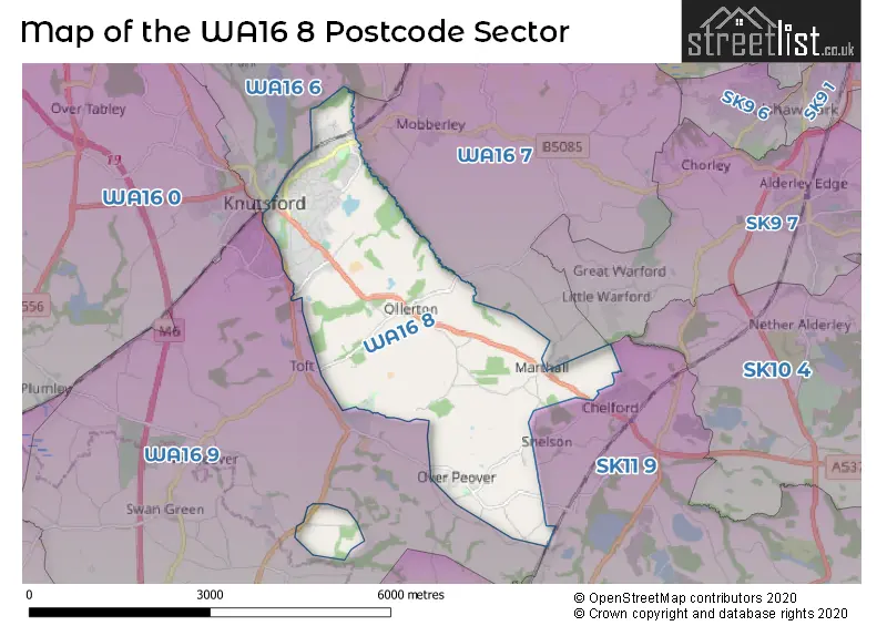
The WA16 8 Postcode shares a border with SK11 9 (Chelford, Gawsworth, Lower Withington), WA16 6 (KNUTSFORD, High Legh, Mere), SK9 7 (ALDERLEY EDGE), WA16 7 (Mobberley, Marthall, KNUTSFORD) and WA16 9 (KNUTSFORD, Allostock, Lower Peover).
Map of the WA16 8 Postcode Sector
Explore the WA16 8 postcode sector by using our interactive map.
The sector is within the post town of KNUTSFORD.
WA16 8 is a postcode sector within the WA16 postcode district which is within the WA Warrington postcode area.
The Royal Mail delivery office for the WA16 8 postal sector is the Knutsford Delivery Office.
The area of the WA16 8 postcode sector is 6.83 square miles which is 17.68 square kilometres or 4,368.95 square acres.
Your support helps keep this site running!
If you enjoy using this website, consider buying me a coffee to help cover hosting costs.


| W | A | 1 | 6 | - | 8 | X | X |
| W | A | 1 | 6 | Space | 8 | Letter | Letter |
Official List of Streets
KNUTSFORD (115 Streets)
Ollerton (15 Streets)
Over Peover (13 Streets)
Marthall (3 Streets)
Knutsford Business Park (1 Streets)
(9 Streets)
Parkgate Industrial Estate (6 Streets)
Toft (2 Streets)
Unofficial Streets or Alternative Spellings
Over Peover
GROTTO LANE HOLMES CHAPEL ROADMarthall
MARTHALL LANESnelson
MILL LANE SNELSON LANEChelford
BATEMILL LANE PEPPER STREETMobberley
KNUTSFORD ROAD BEGGAR MANS LANE BOOTHS PARK CHURCH WALK FAIR MEAD HALL LANE LEGH GARDENS PARKHILL COURT PERCIVALS LANE SAINT JOHNS VALE SANDLE BRIDGE LANE THURNEYHOLME DRIVEToft
TOFT ROADWeather Forecast for WA16 8
Weather Forecast for Knutsford
| Time Period | Icon | Description | Temperature | Rain Probability | Wind |
|---|---|---|---|---|---|
| 00:00 to 03:00 | Cloudy | 7.0°C (feels like 3.0°C) | 8.00% | S 13 mph | |
| 03:00 to 06:00 | Overcast | 7.0°C (feels like 4.0°C) | 8.00% | S 13 mph | |
| 06:00 to 09:00 | Cloudy | 7.0°C (feels like 4.0°C) | 8.00% | S 13 mph | |
| 09:00 to 12:00 | Cloudy | 8.0°C (feels like 4.0°C) | 10.00% | S 16 mph | |
| 12:00 to 15:00 | Cloudy | 9.0°C (feels like 6.0°C) | 53.00% | S 16 mph | |
| 15:00 to 18:00 | Light rain | 9.0°C (feels like 6.0°C) | 56.00% | SW 13 mph | |
| 18:00 to 21:00 | Clear night | 7.0°C (feels like 4.0°C) | 8.00% | SW 11 mph | |
| 21:00 to 00:00 | Clear night | 6.0°C (feels like 3.0°C) | 2.00% | WSW 11 mph |
| Time Period | Icon | Description | Temperature | Rain Probability | Wind |
|---|---|---|---|---|---|
| 00:00 to 03:00 | Clear night | 4.0°C (feels like 1.0°C) | 1.00% | SW 9 mph | |
| 03:00 to 06:00 | Clear night | 4.0°C (feels like 1.0°C) | 0.00% | WSW 9 mph | |
| 06:00 to 09:00 | Partly cloudy (night) | 4.0°C (feels like 1.0°C) | 2.00% | WSW 7 mph | |
| 09:00 to 12:00 | Cloudy | 4.0°C (feels like 2.0°C) | 4.00% | WSW 7 mph | |
| 12:00 to 15:00 | Cloudy | 7.0°C (feels like 5.0°C) | 6.00% | W 9 mph | |
| 15:00 to 18:00 | Sunny day | 7.0°C (feels like 5.0°C) | 1.00% | WNW 9 mph | |
| 18:00 to 21:00 | Clear night | 4.0°C (feels like 2.0°C) | 1.00% | WNW 4 mph | |
| 21:00 to 00:00 | Clear night | 2.0°C (feels like 1.0°C) | 1.00% | W 2 mph |
| Time Period | Icon | Description | Temperature | Rain Probability | Wind |
|---|---|---|---|---|---|
| 00:00 to 03:00 | Clear night | 1.0°C (feels like -1.0°C) | 1.00% | E 2 mph | |
| 03:00 to 06:00 | Clear night | 0.0°C (feels like -2.0°C) | 2.00% | E 2 mph | |
| 06:00 to 09:00 | Clear night | -1.0°C (feels like -3.0°C) | 4.00% | ENE 2 mph | |
| 09:00 to 12:00 | Sunny day | 0.0°C (feels like -1.0°C) | 3.00% | E 2 mph | |
| 12:00 to 15:00 | Sunny day | 5.0°C (feels like 4.0°C) | 0.00% | ESE 4 mph | |
| 15:00 to 18:00 | Sunny day | 7.0°C (feels like 6.0°C) | 0.00% | ESE 4 mph | |
| 18:00 to 21:00 | Clear night | 4.0°C (feels like 1.0°C) | 0.00% | E 4 mph | |
| 21:00 to 00:00 | Clear night | 2.0°C (feels like 0.0°C) | 0.00% | E 4 mph |
| Time Period | Icon | Description | Temperature | Rain Probability | Wind |
|---|---|---|---|---|---|
| 00:00 to 03:00 | Clear night | 1.0°C (feels like -1.0°C) | 1.00% | E 4 mph | |
| 03:00 to 06:00 | Clear night | 1.0°C (feels like -2.0°C) | 2.00% | E 4 mph | |
| 06:00 to 09:00 | Clear night | 0.0°C (feels like -2.0°C) | 2.00% | E 4 mph | |
| 09:00 to 12:00 | Partly cloudy (day) | 2.0°C (feels like -1.0°C) | 4.00% | E 4 mph | |
| 12:00 to 15:00 | Sunny day | 5.0°C (feels like 2.0°C) | 1.00% | E 7 mph | |
| 15:00 to 18:00 | Sunny day | 6.0°C (feels like 4.0°C) | 1.00% | E 7 mph | |
| 18:00 to 21:00 | Clear night | 3.0°C (feels like 0.0°C) | 1.00% | E 7 mph | |
| 21:00 to 00:00 | Clear night | 2.0°C (feels like -1.0°C) | 1.00% | E 7 mph |
Schools and Places of Education Within the WA16 8 Postcode Sector
Manor Park Primary School and Nursery
Academy converter
Manor Park North, Knutsford, Cheshire, WA16 8DB
Head: Mr Simon Cotterill
Ofsted Rating: Good
Inspection: 2023-07-04 (581 days ago)
Website: Visit Manor Park Primary School and Nursery Website
Phone: 01625568837
Number of Pupils: 270
Peover Superior Endowed Primary School
Academy sponsor led
Stocks Lane, Knutsford, Cheshire, WA16 8TU
Head: Mrs Joanne Munro
Ofsted Rating: Outstanding
Inspection: 2023-03-21 (686 days ago)
Website: Visit Peover Superior Endowed Primary School Website
Phone: 01625861384
Number of Pupils: 97
St Vincent De Paul Catholic Primary School
Voluntary aided school
Manor Park South, Knutsford, Cheshire, WA16 8AL
Head: Miss Bernadette Groarke
Ofsted Rating: Good
Inspection: 2022-11-23 (804 days ago)
Website: Visit St Vincent De Paul Catholic Primary School Website
Phone: 01565633637
Number of Pupils: 198
House Prices in the WA16 8 Postcode Sector
| Type of Property | 2018 Average | 2018 Sales | 2017 Average | 2017 Sales | 2016 Average | 2016 Sales | 2015 Average | 2015 Sales |
|---|---|---|---|---|---|---|---|---|
| Detached | £749,913 | 60 | £615,725 | 55 | £580,524 | 55 | £594,231 | 64 |
| Semi-Detached | £313,378 | 37 | £289,669 | 56 | £284,788 | 43 | £297,483 | 38 |
| Terraced | £294,405 | 22 | £287,977 | 26 | £266,203 | 32 | £221,802 | 43 |
| Flats | £159,203 | 15 | £339,000 | 10 | £204,919 | 13 | £200,280 | 10 |
Important Postcodes WA16 8 in the Postcode Sector
WA16 8AL is the postcode for ST VINCENT DE PAUL CATHOLIC PRIMARY SCHOOL, MANOR PARK SOUTH, ST VINCENT DE PAUL CATHOLIC PRIMARY SCHOOL, MANOR PARK SOUTH, KNUTSFORD, and St. Vincents Catholic Primary School, Manor Park South
WA16 8DB is the postcode for MANOR PARK SCHOOL, MAIN BUILDING & EXTENSION, MANOR PARK NORTH, Manor Park School And Nursery, Manor Park North, and Manor Park School & Nursery, Manor Park North
WA16 8PA is the postcode for SPORTS BARN, St. John's Wood Community School, Longridge, St. John's Wood Community School, Longridge, Adelaide Heath Academy, Longridge, and Adelaide Heath Academy, Sports Hall, Longridge
WA16 8TU is the postcode for Peover Superior Endowed (Controlled) Primary School, Stocks Lane
| The WA16 8 Sector is within these Local Authorities |
|
|---|---|
| The WA16 8 Sector is within these Counties |
|
| The WA16 8 Sector is within these Water Company Areas |
|