A wide range of spatial data has been analysed to present this overview of the WA12 9 Postcode sector. If you would like anything added, please contact us.
The WA12 9 postcode sector stands on the Cheshire and Merseyside border.
Did you know? According to the 2021 Census, the WA12 9 postcode sector is home to a bustling 11,651 residents!
Given that each sector allows for 400 unique postcode combinations. Letters C, I, K, M, O and V are not allowed in the last two letters of a postcode. With 315 postcodes already in use, this leaves 85 units available.
The WA12 9 postal code covers the settlement of NEWTON-LE-WILLOWS.
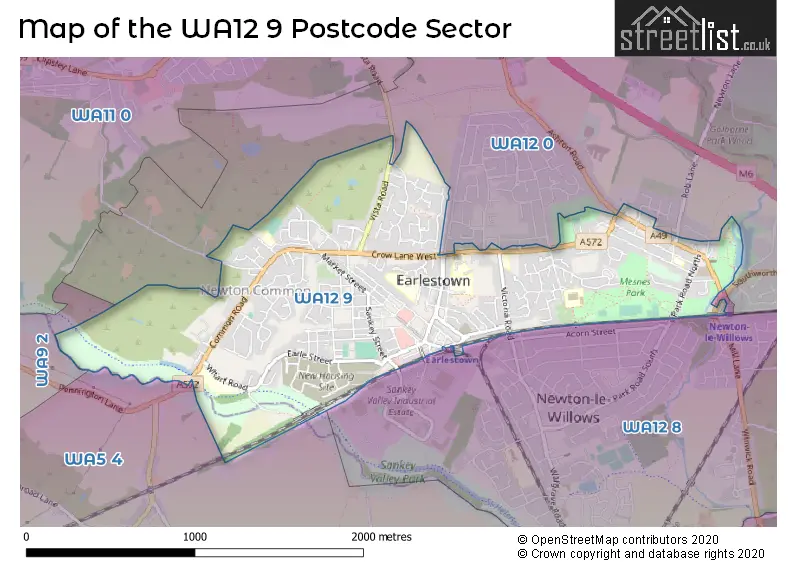
The WA12 9 Postcode shares a border with WA12 0 (NEWTON-LE-WILLOWS), WA5 4 (Burtonwood, Collins Green), WA9 2 (ST. HELENS) and WA12 8 (NEWTON-LE-WILLOWS).
Map of the WA12 9 Postcode Sector
Explore the WA12 9 postcode sector by using our interactive map.
The sector is within the post town of NEWTON-LE-WILLOWS.
WA12 9 is a postcode sector within the WA12 postcode district which is within the WA Warrington postcode area.
The Royal Mail delivery office for the WA12 9 postal sector is the Newton Le Willows Delivery Office.
The area of the WA12 9 postcode sector is 1.26 square miles which is 3.26 square kilometres or 805.09 square acres.
Waterways within the WA12 9 postcode sector include the Sankey Brook, St Helens Canal.
Your support helps keep this site running!
If you enjoy using this website, consider buying me a coffee to help cover hosting costs.


| W | A | 1 | 2 | - | 9 | X | X |
| W | A | 1 | 2 | Space | 9 | Letter | Letter |
Official List of Streets
NEWTON-LE-WILLOWS (185 Streets)
Unofficial Streets or Alternative Spellings
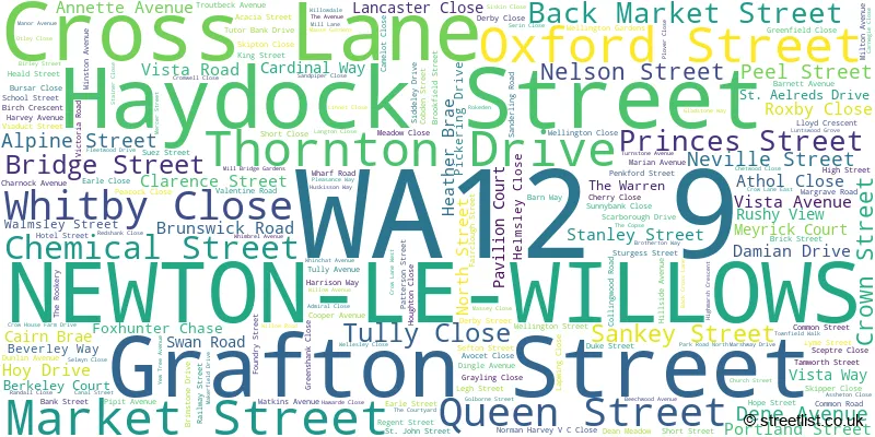
NEWTON-LE-WILLOWS
ASHTON ROAD BELVEDERE ROAD BORRON ROAD CASTLE HILL COLE AVENUE JUNCTION LANE PARK ROAD SOUTH QUEENS DRIVE ROB LANE THE PARCHMENTS WATER STREET ALFRED STREET BLACKBURNE DRIVE CROW HOUSE FARM CLOSE GREENFIELDS CLOSE MEYRICK CLOSE MILLBRIDGE GARDENS NEWTON-LE-WILLOWS STATION SUBWAY PRINCESS STREET SCARRBOROUGH DRIVE THE DINGLE GREENWAY TURNSTONE CLOSEHaydock
VISTA ROADWeather Forecast for WA12 9
Weather Forecast for Newton-Le-Willows
| Time Period | Icon | Description | Temperature | Rain Probability | Wind |
|---|---|---|---|---|---|
| 09:00 to 12:00 | Overcast | 4.0°C (feels like 1.0°C) | 8.00% | SSE 7 mph | |
| 12:00 to 15:00 | Cloudy | 6.0°C (feels like 3.0°C) | 4.00% | SSE 11 mph | |
| 15:00 to 18:00 | Cloudy | 7.0°C (feels like 4.0°C) | 3.00% | SSE 11 mph | |
| 18:00 to 21:00 | Cloudy | 5.0°C (feels like 2.0°C) | 3.00% | SSE 9 mph | |
| 21:00 to 00:00 | Cloudy | 5.0°C (feels like 2.0°C) | 4.00% | SSE 11 mph |
| Time Period | Icon | Description | Temperature | Rain Probability | Wind |
|---|---|---|---|---|---|
| 00:00 to 03:00 | Overcast | 5.0°C (feels like 1.0°C) | 10.00% | SSE 11 mph | |
| 03:00 to 06:00 | Cloudy | 4.0°C (feels like 0.0°C) | 7.00% | SSE 11 mph | |
| 06:00 to 09:00 | Cloudy | 4.0°C (feels like 0.0°C) | 12.00% | SSE 11 mph | |
| 09:00 to 12:00 | Overcast | 4.0°C (feels like 1.0°C) | 15.00% | SSE 9 mph | |
| 12:00 to 15:00 | Overcast | 5.0°C (feels like 2.0°C) | 13.00% | SSE 9 mph | |
| 15:00 to 18:00 | Overcast | 6.0°C (feels like 4.0°C) | 14.00% | S 7 mph | |
| 18:00 to 21:00 | Overcast | 6.0°C (feels like 3.0°C) | 9.00% | S 7 mph | |
| 21:00 to 00:00 | Overcast | 5.0°C (feels like 3.0°C) | 8.00% | S 7 mph |
| Time Period | Icon | Description | Temperature | Rain Probability | Wind |
|---|---|---|---|---|---|
| 00:00 to 03:00 | Cloudy | 5.0°C (feels like 2.0°C) | 7.00% | S 7 mph | |
| 03:00 to 06:00 | Cloudy | 4.0°C (feels like 1.0°C) | 5.00% | SSE 7 mph | |
| 06:00 to 09:00 | Cloudy | 4.0°C (feels like 1.0°C) | 5.00% | SSE 7 mph | |
| 09:00 to 12:00 | Cloudy | 4.0°C (feels like 1.0°C) | 5.00% | SSE 9 mph | |
| 12:00 to 15:00 | Cloudy | 7.0°C (feels like 4.0°C) | 5.00% | S 9 mph | |
| 15:00 to 18:00 | Cloudy | 9.0°C (feels like 6.0°C) | 6.00% | S 11 mph | |
| 18:00 to 21:00 | Partly cloudy (night) | 8.0°C (feels like 5.0°C) | 6.00% | S 11 mph | |
| 21:00 to 00:00 | Partly cloudy (night) | 7.0°C (feels like 4.0°C) | 9.00% | S 11 mph |
| Time Period | Icon | Description | Temperature | Rain Probability | Wind |
|---|---|---|---|---|---|
| 00:00 to 03:00 | Cloudy | 7.0°C (feels like 4.0°C) | 18.00% | S 13 mph | |
| 03:00 to 06:00 | Cloudy | 7.0°C (feels like 4.0°C) | 24.00% | S 11 mph | |
| 06:00 to 09:00 | Cloudy | 8.0°C (feels like 5.0°C) | 25.00% | S 11 mph | |
| 09:00 to 12:00 | Cloudy | 8.0°C (feels like 5.0°C) | 21.00% | SSW 11 mph | |
| 12:00 to 15:00 | Cloudy | 9.0°C (feels like 6.0°C) | 20.00% | SSW 11 mph | |
| 15:00 to 18:00 | Cloudy | 9.0°C (feels like 7.0°C) | 17.00% | SW 11 mph | |
| 18:00 to 21:00 | Partly cloudy (night) | 7.0°C (feels like 5.0°C) | 11.00% | SW 9 mph | |
| 21:00 to 00:00 | Clear night | 7.0°C (feels like 4.0°C) | 5.00% | WSW 9 mph |
Schools and Places of Education Within the WA12 9 Postcode Sector
Lyme Community Primary School
Community school
Lyme Street, Newton-le-Willows, Merseyside, WA12 9HD
Head: Mrs Jo Roberts
Ofsted Rating: Good
Inspection: 2019-09-25 (1956 days ago)
Website: Visit Lyme Community Primary School Website
Phone: 01744678350
Number of Pupils: 220
Newton-le-Willows Primary School
Community school
Sanderling Road, Newton-le-Willows, Merseyside, WA12 9UF
Head: Mrs Lauren Chisnall
Ofsted Rating: Good
Inspection: 2021-09-23 (1227 days ago)
Website: Visit Newton-le-Willows Primary School Website
Phone: 01744678390
Number of Pupils: 631
St Peter's CofE Primary School
Voluntary aided school
Birley Street, Newton-le-Willows, Merseyside, WA12 9UR
Head: Mr Paul Robinson
Ofsted Rating: Outstanding
Inspection: 2013-12-13 (4068 days ago)
Website: Visit St Peter's CofE Primary School Website
Phone: 01744678630
Number of Pupils: 236

House Prices in the WA12 9 Postcode Sector
| Type of Property | 2018 Average | 2018 Sales | 2017 Average | 2017 Sales | 2016 Average | 2016 Sales | 2015 Average | 2015 Sales |
|---|---|---|---|---|---|---|---|---|
| Detached | £215,932 | 72 | £200,154 | 83 | £202,240 | 43 | £215,154 | 51 |
| Semi-Detached | £143,660 | 86 | £137,858 | 82 | £128,092 | 63 | £132,109 | 84 |
| Terraced | £115,970 | 104 | £107,879 | 103 | £101,702 | 96 | £104,129 | 102 |
| Flats | £87,000 | 12 | £88,730 | 15 | £88,979 | 11 | £74,280 | 10 |
Important Postcodes WA12 9 in the Postcode Sector
WA12 9AA is the postcode for Royal Mail, Newton-le-Willows Delivery Office, 2 Haydock Street
WA12 9BW is the postcode for Earlestown Police Station, 52-54 Market Street
WA12 9ED is the postcode for New Vista Locality Centre, Vista Road
WA12 9EU is the postcode for Kershaw Day Centre, Portland Street
WA12 9HD is the postcode for Lyme Community Primary School, Lyme Street
WA12 9NA is the postcode for Patterdale Lodge Medical Centre, Legh Street
WA12 9PZ is the postcode for Infants Building, The District Ce Primary School, Patterson Street, Junior And Admin Building, The District Ce Primary School, Patterson Street, District C of E Primary School, Patterson Street, Newton Childrens Centre, 32 Patterson Street, and INFANT BLOCK THE DISTRICT CE PRIMARY SCHOOL, District C of E Primary School, Patterson Street
WA12 9QQ is the postcode for St. Marys RC Junior School, Barn Way
WA12 9RX is the postcode for St. Marys RC Infant School, Victoria Road
WA12 9TA is the postcode for Mesnes Park Sports Pavilion, Park Road North
WA12 9TT is the postcode for MAIN COMPLEX NEWTON CAMPUS, St. Helens College, Newton Campus, Crow Lane East
WA12 9TU is the postcode for St. Helens Metropolitan Borough Council, Newton-le-Willows Public Library, Crow Lane East
WA12 9TX is the postcode for Newton Health Clinic, Crow Lane East
WA12 9UF is the postcode for Newton Le Willows Primary School, Sanderling Road, and Newton-le-Willows Cp School, Sanderling Road
WA12 9UR is the postcode for St. Peters C of E Primary School, Birley Street, and St Peters Ce Primary School, Birley Street
WA12 9UW is the postcode for St. Aelreds Catholic Technology College
WA12 9XZ is the postcode for Penkford School, Wharf Road
| The WA12 9 Sector is within these Local Authorities |
|
|---|---|
| The WA12 9 Sector is within these Counties |
|
| The WA12 9 Sector is within these Water Company Areas |
|