A wide range of spatial data has been analysed to present this overview of the WA12 0 Postcode sector. If you would like anything added, please contact us.
The WA12 0 postcode sector stands on the Greater Manchester and Merseyside border.
Did you know? According to the 2021 Census, the WA12 0 postcode sector is home to a bustling 4,835 residents!
Given that each sector allows for 400 unique postcode combinations. Letters C, I, K, M, O and V are not allowed in the last two letters of a postcode. With 128 postcodes already in use, this leaves 272 units available.
The WA12 0 postal code covers the settlement of NEWTON-LE-WILLOWS.
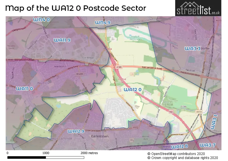
The WA12 0 Postcode shares a border with WA3 1 (Lowton), WA3 7 (Birchwood, Croft), WA3 3 (Golborne), WA11 0 (Haydock), WA11 9 (ST. HELENS, Haydock), WN4 9 (Ashton-in-Makerfield), WA9 2 (ST. HELENS), WA12 8 (NEWTON-LE-WILLOWS) and WA12 9 (NEWTON-LE-WILLOWS).
Map of the WA12 0 Postcode Sector
Explore the WA12 0 postcode sector by using our interactive map.
The sector is within the post town of NEWTON-LE-WILLOWS.
WA12 0 is a postcode sector within the WA12 postcode district which is within the WA Warrington postcode area.
The Royal Mail delivery office for the WA12 0 postal sector is the Newton Le Willows Delivery Office.
The area of the WA12 0 postcode sector is 2.63 square miles which is 6.82 square kilometres or 1,686.07 square acres.
The WA12 0 postcode sector is crossed by the A580 Major A road.
The WA12 0 postcode sector is crossed by the M6 motorway.
Waterways within the WA12 0 postcode sector include the Millingford Brook.
Your support helps keep this site running!
If you enjoy using this website, consider buying me a coffee to help cover hosting costs.

| W | A | 1 | 2 | - | 0 | X | X |
| W | A | 1 | 2 | Space | 0 | Letter | Letter |
Official List of Streets
NEWTON-LE-WILLOWS (65 Streets)
(3 Streets)
Golborne Dale (1 Streets)
Unofficial Streets or Alternative Spellings
NEWTON-LE-WILLOWS
CROW LANE EAST CROW LANE WEST MAKERFIELD DRIVEGlazebury
EAST LANCASHIRE ROADLowton
NEWTON ROAD PARKSIDE ROAD CROWN PARK GARDENS FIELD PATH HAYDOCK ISLAND MC CORQUODALE GARDENS SERPENTINE WALK WATERWORKS DRIVE WILLOW BANK ESTATEHaydock
GRANGE ROAD PENNY LANE VISTA ROADWeather Forecast for WA12 0
Weather Forecast for Haydock Park Racecourse
| Time Period | Icon | Description | Temperature | Rain Probability | Wind |
|---|---|---|---|---|---|
| 15:00 to 18:00 | Cloudy | 10.0°C (feels like 7.0°C) | 5.00% | S 9 mph | |
| 18:00 to 21:00 | Cloudy | 8.0°C (feels like 6.0°C) | 5.00% | S 9 mph | |
| 21:00 to 00:00 | Overcast | 7.0°C (feels like 4.0°C) | 8.00% | S 11 mph |
| Time Period | Icon | Description | Temperature | Rain Probability | Wind |
|---|---|---|---|---|---|
| 00:00 to 03:00 | Cloudy | 7.0°C (feels like 4.0°C) | 9.00% | SSE 11 mph | |
| 03:00 to 06:00 | Cloudy | 7.0°C (feels like 4.0°C) | 8.00% | SSE 11 mph | |
| 06:00 to 09:00 | Overcast | 8.0°C (feels like 5.0°C) | 11.00% | S 11 mph | |
| 09:00 to 12:00 | Overcast | 8.0°C (feels like 5.0°C) | 13.00% | S 13 mph | |
| 12:00 to 15:00 | Cloudy | 9.0°C (feels like 6.0°C) | 21.00% | S 16 mph | |
| 15:00 to 18:00 | Light rain | 9.0°C (feels like 7.0°C) | 86.00% | WSW 11 mph | |
| 18:00 to 21:00 | Clear night | 8.0°C (feels like 5.0°C) | 6.00% | SW 11 mph | |
| 21:00 to 00:00 | Clear night | 7.0°C (feels like 3.0°C) | 2.00% | WSW 11 mph |
| Time Period | Icon | Description | Temperature | Rain Probability | Wind |
|---|---|---|---|---|---|
| 00:00 to 03:00 | Clear night | 5.0°C (feels like 2.0°C) | 2.00% | WSW 9 mph | |
| 03:00 to 06:00 | Partly cloudy (night) | 5.0°C (feels like 2.0°C) | 4.00% | WSW 9 mph | |
| 06:00 to 09:00 | Cloudy | 5.0°C (feels like 2.0°C) | 5.00% | WSW 9 mph | |
| 09:00 to 12:00 | Cloudy | 5.0°C (feels like 3.0°C) | 4.00% | WSW 7 mph | |
| 12:00 to 15:00 | Cloudy | 7.0°C (feels like 5.0°C) | 6.00% | W 9 mph | |
| 15:00 to 18:00 | Sunny day | 7.0°C (feels like 5.0°C) | 1.00% | WNW 9 mph | |
| 18:00 to 21:00 | Clear night | 4.0°C (feels like 3.0°C) | 1.00% | WNW 4 mph | |
| 21:00 to 00:00 | Clear night | 3.0°C (feels like 2.0°C) | 1.00% | WNW 2 mph |
| Time Period | Icon | Description | Temperature | Rain Probability | Wind |
|---|---|---|---|---|---|
| 00:00 to 03:00 | Clear night | 2.0°C (feels like 0.0°C) | 1.00% | E 2 mph | |
| 03:00 to 06:00 | Clear night | 1.0°C (feels like -1.0°C) | 2.00% | E 2 mph | |
| 06:00 to 09:00 | Clear night | 0.0°C (feels like -2.0°C) | 3.00% | E 2 mph | |
| 09:00 to 12:00 | Sunny day | 1.0°C (feels like -1.0°C) | 2.00% | E 4 mph | |
| 12:00 to 15:00 | Sunny day | 5.0°C (feels like 4.0°C) | 0.00% | ESE 4 mph | |
| 15:00 to 18:00 | Sunny day | 7.0°C (feels like 6.0°C) | 0.00% | ESE 4 mph | |
| 18:00 to 21:00 | Clear night | 4.0°C (feels like 2.0°C) | 0.00% | E 7 mph | |
| 21:00 to 00:00 | Clear night | 3.0°C (feels like 0.0°C) | 0.00% | E 7 mph |
| Time Period | Icon | Description | Temperature | Rain Probability | Wind |
|---|---|---|---|---|---|
| 00:00 to 03:00 | Clear night | 2.0°C (feels like -1.0°C) | 0.00% | E 7 mph | |
| 03:00 to 06:00 | Clear night | 1.0°C (feels like -1.0°C) | 1.00% | E 7 mph | |
| 06:00 to 09:00 | Clear night | 1.0°C (feels like -2.0°C) | 2.00% | E 7 mph | |
| 09:00 to 12:00 | Partly cloudy (day) | 2.0°C (feels like -1.0°C) | 3.00% | E 7 mph | |
| 12:00 to 15:00 | Sunny day | 5.0°C (feels like 2.0°C) | 1.00% | E 7 mph | |
| 15:00 to 18:00 | Sunny day | 6.0°C (feels like 4.0°C) | 1.00% | E 7 mph | |
| 18:00 to 21:00 | Clear night | 4.0°C (feels like 1.0°C) | 1.00% | E 7 mph | |
| 21:00 to 00:00 | Clear night | 2.0°C (feels like 0.0°C) | 1.00% | E 7 mph |
Schools and Places of Education Within the WA12 0 Postcode Sector
Hope Academy
Academy sponsor led
Ashton Road, Newton-le-Willows, Merseyside, WA12 0AQ
Head: Mrs Marie Adams
Ofsted Rating: Requires improvement
Inspection: 2021-09-29 (1223 days ago)
Website: Visit Hope Academy Website
Phone: 01744671930
Number of Pupils: 1351
House Prices in the WA12 0 Postcode Sector
| Type of Property | 2018 Average | 2018 Sales | 2017 Average | 2017 Sales | 2016 Average | 2016 Sales | 2015 Average | 2015 Sales |
|---|---|---|---|---|---|---|---|---|
| Detached | £280,222 | 18 | £305,309 | 16 | £248,802 | 31 | £242,977 | 22 |
| Semi-Detached | £166,703 | 35 | £121,370 | 27 | £143,183 | 24 | £118,950 | 26 |
| Terraced | £127,006 | 9 | £109,025 | 16 | £104,813 | 16 | £121,166 | 16 |
| Flats | £64,667 | 3 | £69,049 | 5 | £78,975 | 18 | £83,333 | 3 |
Important Postcodes WA12 0 in the Postcode Sector
WA12 0AQ is the postcode for Selwyn Jones Sports Centre, Ashton Road, Newton-le-Willows High School, Ashton Road, Hope Academy, Ashton Road, NEWTON BUILDING & SPORTS HALL, Newton-le-Willows High School, Ashton Road, and NEWTON LE WILLOWS HEALTH AND FITNESS, ASHTON ROAD
WA12 0DS is the postcode for Highways Agency Traffic Control Centre, Rob Lane
WA12 0EL is the postcode for Merseyside Fire & Rescue Service, Fire Station, Borron Road
| The WA12 0 Sector is within these Local Authorities |
|
|---|---|
| The WA12 0 Sector is within these Counties |
|
| The WA12 0 Sector is within these Water Company Areas |
|