A wide range of spatial data has been analysed to present this overview of the TW6 2 Postcode sector. If you would like anything added, please contact us.
The TW6 2 postcode sector is within the county of Greater London.
Did you know? According to the 2021 Census, the TW6 2 postcode sector is home to a bustling 9 residents!
Given that each sector allows for 400 unique postcode combinations. Letters C, I, K, M, O and V are not allowed in the last two letters of a postcode. With 57 postcodes already in use, this leaves 343 units available.
The largest settlements in the TW6 2 postal code are LONDON HEATHROW AIRPORT and HEATHROW .
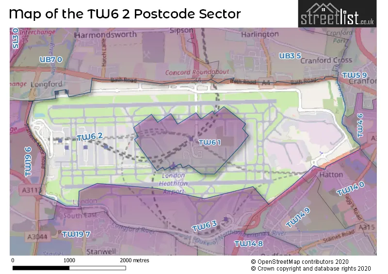
The TW6 2 Postcode shares a border with TW4 6 (HOUNSLOW ), TW14 0 (FELTHAM ), TW14 9 (FELTHAM ), TW19 7 (STANWELL), UB3 5 (HAYES , HARLINGTON , HEATHROW ), TW5 9 (HOUNSLOW , CRANFORD , BRENTFORD ), TW19 6 (STANWELL MOOR, STAINES-UPON-THAMES, WRAYSBURY) and UB7 0 (WEST DRAYTON , LONGFORD , SIPSON ).
Map of the TW6 2 Postcode Sector
Explore the TW6 2 postcode sector by using our interactive map.
The sector is within the post town of HOUNSLOW.
TW6 2 is a postcode sector within the TW6 postcode district which is within the TW Twickenham postcode area.
The Royal Mail delivery office for the TW6 2 postal sector is the Hounslow Delivery Office.
The area of the TW6 2 postcode sector is 3.31 square miles which is 8.56 square kilometres or 2,116.07 square acres.
The TW6 2 postcode sector is crossed by the M4 motorway.
The TW6 2 postcode sector is crossed by the M25 motorway.
The TW6 2 postcode sector is crossed by the A3113 Major A road.
Waterways within the TW6 2 postcode sector include the Longford River, River Crane, Duke of Northumberland's River.
Your support helps keep this site running!
If you enjoy using this website, consider buying me a coffee to help cover hosting costs.

| T | W | 6 | - | 2 | X | X |
| T | W | 6 | Space | 2 | Letter | Letter |
Official List of Streets
(50 Streets)
London Heathrow Airport (20 Streets)
Unofficial Streets or Alternative Spellings
London Heathrow Airport
SOUTHERN PERIMETER ROADFELTHAM
DICK TURPIN WAY GIRLING WAYBedfont
GREAT SOUTH WEST ROAD HATTON ROADHOUNSLOW
SILVER JUBILEE WAYHAYES
CRANESWATER LANGLEY CRESCENTHarlington
MONDIAL WAY NEW ROAD NOBEL DRIVESipson
SIPSON ROADHarmondsworth
HATCH LANESTAINES-UPON-THAMES
STANWELL MOOR ROADColnbrook
BATH ROADWeather Forecast for TW6 2
Weather Forecast for Heathrow
| Time Period | Icon | Description | Temperature | Rain Probability | Wind |
|---|---|---|---|---|---|
| 03:00 to 06:00 | Partly cloudy (night) | 3.0°C (feels like 0.0°C) | 1.00% | SE 7 mph | |
| 06:00 to 09:00 | Clear night | 2.0°C (feels like 0.0°C) | 0.00% | SE 4 mph | |
| 09:00 to 12:00 | Sunny day | 3.0°C (feels like 0.0°C) | 0.00% | SE 7 mph | |
| 12:00 to 15:00 | Sunny day | 6.0°C (feels like 4.0°C) | 0.00% | SSE 7 mph | |
| 15:00 to 18:00 | Sunny day | 7.0°C (feels like 5.0°C) | 0.00% | S 7 mph | |
| 18:00 to 21:00 | Clear night | 5.0°C (feels like 3.0°C) | 0.00% | SSW 4 mph | |
| 21:00 to 00:00 | Clear night | 3.0°C (feels like 2.0°C) | 1.00% | S 4 mph |
| Time Period | Icon | Description | Temperature | Rain Probability | Wind |
|---|---|---|---|---|---|
| 00:00 to 03:00 | Clear night | 2.0°C (feels like 0.0°C) | 1.00% | SSW 4 mph | |
| 03:00 to 06:00 | Cloudy | 1.0°C (feels like -1.0°C) | 5.00% | S 4 mph | |
| 06:00 to 09:00 | Overcast | 1.0°C (feels like 0.0°C) | 9.00% | SSW 4 mph | |
| 09:00 to 12:00 | Overcast | 3.0°C (feels like 1.0°C) | 9.00% | S 4 mph | |
| 12:00 to 15:00 | Overcast | 7.0°C (feels like 5.0°C) | 8.00% | S 7 mph | |
| 15:00 to 18:00 | Partly cloudy (day) | 8.0°C (feels like 6.0°C) | 2.00% | SSW 9 mph | |
| 18:00 to 21:00 | Partly cloudy (night) | 6.0°C (feels like 4.0°C) | 2.00% | S 9 mph | |
| 21:00 to 00:00 | Partly cloudy (night) | 5.0°C (feels like 3.0°C) | 2.00% | S 9 mph |
| Time Period | Icon | Description | Temperature | Rain Probability | Wind |
|---|---|---|---|---|---|
| 00:00 to 03:00 | Cloudy | 5.0°C (feels like 2.0°C) | 5.00% | S 9 mph | |
| 03:00 to 06:00 | Partly cloudy (night) | 5.0°C (feels like 2.0°C) | 3.00% | S 9 mph | |
| 06:00 to 09:00 | Partly cloudy (night) | 5.0°C (feels like 2.0°C) | 3.00% | S 9 mph | |
| 09:00 to 12:00 | Partly cloudy (day) | 6.0°C (feels like 3.0°C) | 3.00% | S 9 mph | |
| 12:00 to 15:00 | Cloudy | 9.0°C (feels like 7.0°C) | 6.00% | SSW 13 mph | |
| 15:00 to 18:00 | Overcast | 10.0°C (feels like 7.0°C) | 14.00% | SSW 13 mph | |
| 18:00 to 21:00 | Light rain | 9.0°C (feels like 7.0°C) | 46.00% | SSW 11 mph | |
| 21:00 to 00:00 | Cloudy | 8.0°C (feels like 6.0°C) | 15.00% | SW 9 mph |
| Time Period | Icon | Description | Temperature | Rain Probability | Wind |
|---|---|---|---|---|---|
| 00:00 to 03:00 | Clear night | 7.0°C (feels like 4.0°C) | 5.00% | W 7 mph | |
| 03:00 to 06:00 | Clear night | 5.0°C (feels like 3.0°C) | 5.00% | W 7 mph | |
| 06:00 to 09:00 | Clear night | 4.0°C (feels like 2.0°C) | 2.00% | WNW 4 mph | |
| 09:00 to 12:00 | Cloudy | 4.0°C (feels like 2.0°C) | 4.00% | NW 4 mph | |
| 12:00 to 15:00 | Cloudy | 7.0°C (feels like 6.0°C) | 4.00% | NNW 7 mph | |
| 15:00 to 18:00 | Cloudy | 8.0°C (feels like 7.0°C) | 5.00% | N 7 mph | |
| 18:00 to 21:00 | Cloudy | 6.0°C (feels like 5.0°C) | 5.00% | N 4 mph | |
| 21:00 to 00:00 | Cloudy | 5.0°C (feels like 4.0°C) | 4.00% | N 4 mph |
House Prices in the TW6 2 Postcode Sector
| Type of Property | 2018 Average | 2018 Sales | 2017 Average | 2017 Sales | 2016 Average | 2016 Sales | 2015 Average | 2015 Sales |
|---|---|---|---|---|---|---|---|---|
| Detached | £0 | 0 | £0 | 0 | £0 | 0 | £0 | 0 |
| Semi-Detached | £0 | 0 | £0 | 0 | £0 | 0 | £0 | 0 |
| Terraced | £0 | 0 | £0 | 0 | £0 | 0 | £0 | 0 |
| Flats | £0 | 0 | £0 | 0 | £0 | 0 | £0 | 0 |
Important Postcodes TW6 2 in the Postcode Sector
TW6 2DJ is the postcode for Metropolitan Police, Northside,
TW6 2LA is the postcode for HM Revenue & Customs, Customs House Building 495
| The TW6 2 Sector is within these Local Authorities |
|
|---|---|
| The TW6 2 Sector is within these Counties |
|
| The TW6 2 Sector is within these Water Company Areas |
|