A wide range of spatial data has been analysed to present this overview of the TA10 0 Postcode sector. If you would like anything added, please contact us.
The TA10 0 postcode sector is within the county of Somerset.
Did you know? According to the 2021 Census, the TA10 0 postcode sector is home to a bustling 4,111 residents!
Given that each sector allows for 400 unique postcode combinations. Letters C, I, K, M, O and V are not allowed in the last two letters of a postcode. With 183 postcodes already in use, this leaves 217 units available.
The largest settlement in the TA10 0 postal code is Curry Rivel followed by Hambridge, and Drayton.
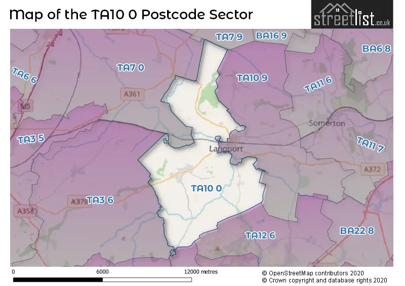
The TA10 0 Postcode shares a border with TA7 0 (Westonzoyland, Middlezoy, North Newton), TA7 9 (Ashcott, Chilton Polden, Catcott), TA10 9 (LANGPORT, Long Sutton, Pitney), TA12 6 (MARTOCK, Kingsbury Episcopi, Bower Hinton), TA3 6 (North Curry, Stoke St. Gregory, Fivehead) and TA19 0 (ILMINSTER, Shepton Beauchamp, Seavington).
Map of the TA10 0 Postcode Sector
Explore the TA10 0 postcode sector by using our interactive map.
The sector is within the post town of LANGPORT.
TA10 0 is a postcode sector within the TA10 postcode district which is within the TA Taunton postcode area.
The Royal Mail delivery office for the TA10 0 postal sector is the Langport Delivery Office.
The area of the TA10 0 postcode sector is 21.84 square miles which is 56.58 square kilometres or 13,980.31 square acres.
Waterways within the TA10 0 postcode sector include the River Parratt, Kings Sedgemoor Drain, Westport Canal, River Yeo, River Isle.
Your support helps keep this site running!
If you enjoy using this website, consider buying me a coffee to help cover hosting costs.


| T | A | 1 | 0 | - | 0 | X | X |
| T | A | 1 | 0 | Space | 0 | Letter | Letter |
Official List of Streets
Curry Rivel (43 Streets)
Hambridge (10 Streets)
Aller (9 Streets)
LANGPORT (4 Streets)
(42 Streets)
Drayton (7 Streets)
Huish Episcopi (2 Streets)
Bowdens (1 Streets)
Muchelney (2 Streets)
Westport (1 Streets)
Unofficial Streets or Alternative Spellings
LANGPORT
BOW STREET WEARNE LANE WESTOVER TRADING ESTATE WETMOOR LANEHuish Episcopi
NEWTOWN ROADStathe
WICKMOORWeather Forecast for TA10 0
Weather Forecast for Drayton (Somerset)
| Time Period | Icon | Description | Temperature | Rain Probability | Wind |
|---|---|---|---|---|---|
| 00:00 to 03:00 | Cloudy | 7.0°C (feels like 5.0°C) | 3.00% | S 9 mph | |
| 03:00 to 06:00 | Cloudy | 8.0°C (feels like 6.0°C) | 5.00% | SSW 11 mph | |
| 06:00 to 09:00 | Overcast | 9.0°C (feels like 6.0°C) | 8.00% | S 11 mph | |
| 09:00 to 12:00 | Overcast | 10.0°C (feels like 6.0°C) | 9.00% | SSW 16 mph | |
| 12:00 to 15:00 | Overcast | 11.0°C (feels like 7.0°C) | 17.00% | SSW 20 mph | |
| 15:00 to 18:00 | Heavy rain | 10.0°C (feels like 8.0°C) | 88.00% | SW 13 mph | |
| 18:00 to 21:00 | Partly cloudy (night) | 8.0°C (feels like 6.0°C) | 10.00% | WSW 9 mph | |
| 21:00 to 00:00 | Clear night | 7.0°C (feels like 4.0°C) | 1.00% | WSW 9 mph |
| Time Period | Icon | Description | Temperature | Rain Probability | Wind |
|---|---|---|---|---|---|
| 00:00 to 03:00 | Clear night | 6.0°C (feels like 3.0°C) | 0.00% | WSW 9 mph | |
| 03:00 to 06:00 | Clear night | 5.0°C (feels like 2.0°C) | 1.00% | WSW 9 mph | |
| 06:00 to 09:00 | Cloudy | 5.0°C (feels like 3.0°C) | 5.00% | WSW 7 mph | |
| 09:00 to 12:00 | Cloudy | 6.0°C (feels like 4.0°C) | 5.00% | WSW 4 mph | |
| 12:00 to 15:00 | Cloudy | 8.0°C (feels like 7.0°C) | 5.00% | WNW 7 mph | |
| 15:00 to 18:00 | Cloudy | 8.0°C (feels like 7.0°C) | 4.00% | NW 7 mph | |
| 18:00 to 21:00 | Cloudy | 6.0°C (feels like 4.0°C) | 4.00% | NW 4 mph | |
| 21:00 to 00:00 | Partly cloudy (night) | 4.0°C (feels like 3.0°C) | 1.00% | NNE 4 mph |
| Time Period | Icon | Description | Temperature | Rain Probability | Wind |
|---|---|---|---|---|---|
| 00:00 to 03:00 | Partly cloudy (night) | 3.0°C (feels like 1.0°C) | 1.00% | ENE 4 mph | |
| 03:00 to 06:00 | Partly cloudy (night) | 2.0°C (feels like 0.0°C) | 1.00% | ENE 7 mph | |
| 06:00 to 09:00 | Clear night | 2.0°C (feels like -1.0°C) | 1.00% | ENE 7 mph | |
| 09:00 to 12:00 | Sunny day | 3.0°C (feels like 0.0°C) | 1.00% | E 7 mph | |
| 12:00 to 15:00 | Sunny day | 7.0°C (feels like 4.0°C) | 0.00% | E 9 mph | |
| 15:00 to 18:00 | Sunny day | 8.0°C (feels like 5.0°C) | 1.00% | E 11 mph | |
| 18:00 to 21:00 | Clear night | 5.0°C (feels like 2.0°C) | 1.00% | ENE 9 mph | |
| 21:00 to 00:00 | Clear night | 4.0°C (feels like 0.0°C) | 1.00% | ENE 9 mph |
| Time Period | Icon | Description | Temperature | Rain Probability | Wind |
|---|---|---|---|---|---|
| 00:00 to 03:00 | Clear night | 3.0°C (feels like -1.0°C) | 1.00% | ENE 9 mph | |
| 03:00 to 06:00 | Clear night | 2.0°C (feels like -2.0°C) | 2.00% | ENE 9 mph | |
| 06:00 to 09:00 | Partly cloudy (night) | 2.0°C (feels like -2.0°C) | 3.00% | ENE 9 mph | |
| 09:00 to 12:00 | Partly cloudy (day) | 3.0°C (feels like -1.0°C) | 4.00% | ENE 11 mph | |
| 12:00 to 15:00 | Cloudy | 5.0°C (feels like 1.0°C) | 5.00% | ENE 11 mph | |
| 15:00 to 18:00 | Partly cloudy (day) | 6.0°C (feels like 3.0°C) | 2.00% | ENE 11 mph | |
| 18:00 to 21:00 | Clear night | 4.0°C (feels like 1.0°C) | 1.00% | NE 9 mph | |
| 21:00 to 00:00 | Clear night | 3.0°C (feels like 0.0°C) | 2.00% | ENE 9 mph |
Schools and Places of Education Within the TA10 0 Postcode Sector
Curry Rivel Church of England VC Primary School
Voluntary controlled school
Church Street, Langport, Somerset, TA10 0HD
Head: Mrs Alison Pook
Ofsted Rating: Good
Inspection: 2023-06-14 (601 days ago)
Website: Visit Curry Rivel Church of England VC Primary School Website
Phone: 01458251404
Number of Pupils: 202
Hambridge Community Primary School
Academy converter
Hambridge, Langport, Somerset, TA10 0AZ
Head: Mrs Leanne Hall
Ofsted Rating: Good
Inspection: 2023-04-26 (650 days ago)
Website: Visit Hambridge Community Primary School Website
Phone: 01460281370
Number of Pupils: 118
House Prices in the TA10 0 Postcode Sector
| Type of Property | 2018 Average | 2018 Sales | 2017 Average | 2017 Sales | 2016 Average | 2016 Sales | 2015 Average | 2015 Sales |
|---|---|---|---|---|---|---|---|---|
| Detached | £349,002 | 49 | £382,336 | 45 | £344,220 | 48 | £310,102 | 49 |
| Semi-Detached | £251,857 | 21 | £216,500 | 11 | £245,129 | 18 | £233,171 | 14 |
| Terraced | £170,347 | 9 | £175,250 | 6 | £254,000 | 8 | £213,714 | 7 |
| Flats | £0 | 0 | £0 | 0 | £0 | 0 | £71,750 | 2 |
Important Postcodes TA10 0 in the Postcode Sector
TA10 0AZ is the postcode for Hambridge Primary School, Hambridge
TA10 0HD is the postcode for Curry Rivel Primary School, Church Street
| The TA10 0 Sector is within these Local Authorities |
|
|---|---|
| The TA10 0 Sector is within these Counties |
|
| The TA10 0 Sector is within these Water Company Areas |
|
Tourist Attractions within the TA10 0 Postcode Area
We found 1 visitor attractions within the TA10 postcode area
| Muchelney Abbey |
|---|
| Historic Properties |
| Historic Monument / Archaeological Site |
| View Muchelney Abbey on Google Maps |