A wide range of spatial data has been analysed to present this overview of the SY5 6 Postcode sector. If you would like anything added, please contact us.
The SY5 6 postcode sector is within the county of Shropshire.
Did you know? According to the 2021 Census, the SY5 6 postcode sector is home to a bustling 3,857 residents!
Given that each sector allows for 400 unique postcode combinations. Letters C, I, K, M, O and V are not allowed in the last two letters of a postcode. With 194 postcodes already in use, this leaves 206 units available.
The largest settlement in the SY5 6 postal code is Cross Houses followed by Cressage, and Cound.
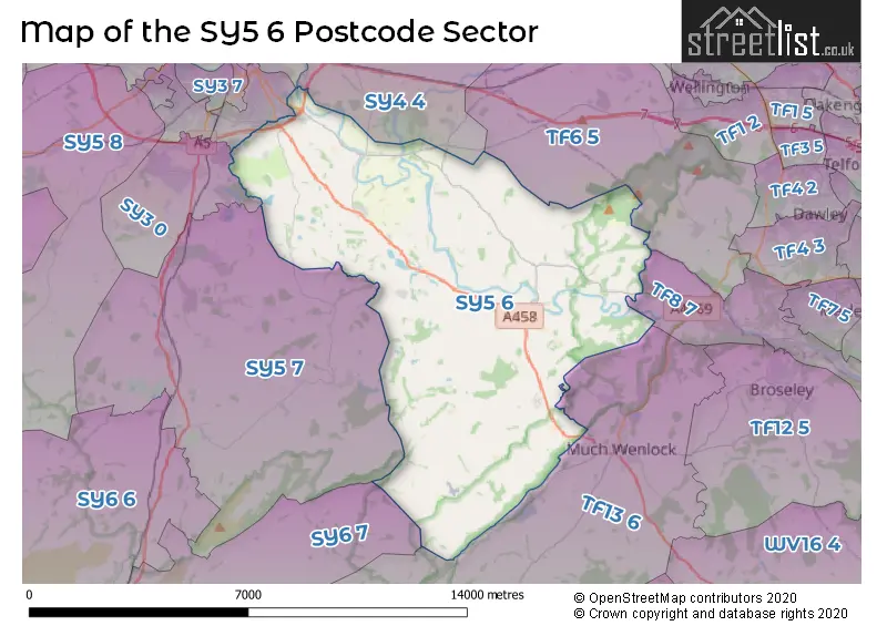
The SY5 6 Postcode shares a border with TF6 5 (Allscott, Little Wenlock, Wrockwardine), TF8 7 (Ironbridge, Coalbrookdale, Jackfield), TF13 6 (MUCH WENLOCK, Homer, Brockton), SY4 4 (Shawbury, Hadnall, Uffington), SY5 7 (Dorrington, Condover, Longnor), SY2 5 (SHREWSBURY), SY2 6 (SHREWSBURY), SY3 0 (Bayston Hill, Lyth Bank) and SY6 7 (CHURCH STRETTON, Cardington, Wall-under-Heywood).
Map of the SY5 6 Postcode Sector
Explore the SY5 6 postcode sector by using our interactive map.
The sector is within the post town of SHREWSBURY.
SY5 6 is a postcode sector within the SY5 postcode district which is within the SY Shrewsbury postcode area.
The Royal Mail delivery office for the SY5 6 postal sector is the Cressage Scale Payment Delivery Office and Shrewsbury Delivery Office.
The area of the SY5 6 postcode sector is 37.89 square miles which is 98.13 square kilometres or 24,247.63 square acres.
Your support helps keep this site running!
If you enjoy using this website, consider buying me a coffee to help cover hosting costs.


| S | Y | 5 | - | 6 | X | X |
| S | Y | 5 | Space | 6 | Letter | Letter |
Official List of Streets
Cressage (17 Streets)
Cross Houses (15 Streets)
(15 Streets)
Cound (6 Streets)
Wroxeter (4 Streets)
Eaton Constantine (4 Streets)
Leighton (4 Streets)
Harley (1 Streets)
SHREWSBURY (1 Streets)
Unofficial Streets or Alternative Spellings
Cressage
BUILDWAS PARKMUCH WENLOCK
BLAKEWAY HOLLOWSHREWSBURY
GREEN CRESCENT HENDRICK CRESCENT THIEVES LANEWeather Forecast for SY5 6
Weather Forecast for Cressage
| Time Period | Icon | Description | Temperature | Rain Probability | Wind |
|---|---|---|---|---|---|
| 09:00 to 12:00 | Cloudy | 4.0°C (feels like 2.0°C) | 8.00% | SSE 4 mph | |
| 12:00 to 15:00 | Cloudy | 6.0°C (feels like 3.0°C) | 4.00% | S 11 mph | |
| 15:00 to 18:00 | Cloudy | 7.0°C (feels like 4.0°C) | 4.00% | S 11 mph | |
| 18:00 to 21:00 | Cloudy | 6.0°C (feels like 2.0°C) | 3.00% | SSE 11 mph | |
| 21:00 to 00:00 | Cloudy | 5.0°C (feels like 1.0°C) | 8.00% | SSE 11 mph |
| Time Period | Icon | Description | Temperature | Rain Probability | Wind |
|---|---|---|---|---|---|
| 00:00 to 03:00 | Overcast | 5.0°C (feels like 1.0°C) | 9.00% | SSE 11 mph | |
| 03:00 to 06:00 | Overcast | 4.0°C (feels like 1.0°C) | 9.00% | SSE 11 mph | |
| 06:00 to 09:00 | Overcast | 4.0°C (feels like 0.0°C) | 11.00% | SSE 9 mph | |
| 09:00 to 12:00 | Overcast | 4.0°C (feels like 0.0°C) | 12.00% | SSE 9 mph | |
| 12:00 to 15:00 | Cloudy | 6.0°C (feels like 3.0°C) | 8.00% | S 9 mph | |
| 15:00 to 18:00 | Cloudy | 7.0°C (feels like 5.0°C) | 7.00% | SSW 7 mph | |
| 18:00 to 21:00 | Cloudy | 5.0°C (feels like 3.0°C) | 6.00% | S 7 mph | |
| 21:00 to 00:00 | Partly cloudy (night) | 4.0°C (feels like 2.0°C) | 2.00% | SSW 7 mph |
| Time Period | Icon | Description | Temperature | Rain Probability | Wind |
|---|---|---|---|---|---|
| 00:00 to 03:00 | Cloudy | 4.0°C (feels like 2.0°C) | 4.00% | S 7 mph | |
| 03:00 to 06:00 | Overcast | 4.0°C (feels like 2.0°C) | 8.00% | S 7 mph | |
| 06:00 to 09:00 | Cloudy | 4.0°C (feels like 1.0°C) | 5.00% | S 7 mph | |
| 09:00 to 12:00 | Cloudy | 5.0°C (feels like 2.0°C) | 5.00% | S 9 mph | |
| 12:00 to 15:00 | Cloudy | 8.0°C (feels like 5.0°C) | 4.00% | SSW 11 mph | |
| 15:00 to 18:00 | Partly cloudy (day) | 9.0°C (feels like 6.0°C) | 2.00% | SSW 11 mph | |
| 18:00 to 21:00 | Cloudy | 7.0°C (feels like 4.0°C) | 5.00% | S 11 mph | |
| 21:00 to 00:00 | Cloudy | 7.0°C (feels like 4.0°C) | 5.00% | S 11 mph |
| Time Period | Icon | Description | Temperature | Rain Probability | Wind |
|---|---|---|---|---|---|
| 00:00 to 03:00 | Overcast | 7.0°C (feels like 4.0°C) | 12.00% | S 13 mph | |
| 03:00 to 06:00 | Overcast | 8.0°C (feels like 4.0°C) | 14.00% | S 13 mph | |
| 06:00 to 09:00 | Cloudy | 8.0°C (feels like 5.0°C) | 15.00% | S 13 mph | |
| 09:00 to 12:00 | Cloudy | 8.0°C (feels like 5.0°C) | 16.00% | SSW 13 mph | |
| 12:00 to 15:00 | Cloudy | 10.0°C (feels like 7.0°C) | 16.00% | SSW 13 mph | |
| 15:00 to 18:00 | Cloudy | 10.0°C (feels like 8.0°C) | 13.00% | SW 11 mph | |
| 18:00 to 21:00 | Partly cloudy (night) | 7.0°C (feels like 5.0°C) | 9.00% | WSW 9 mph | |
| 21:00 to 00:00 | Clear night | 6.0°C (feels like 4.0°C) | 5.00% | WSW 9 mph |
Schools and Places of Education Within the SY5 6 Postcode Sector
Christ Church CofE Primary School
Voluntary controlled school
Sheinton Road, Shrewsbury, Shropshire, SY5 6DH
Head: Mrs Tracey Cansdale
Ofsted Rating: Good
Inspection: 2023-07-04 (578 days ago)
Website: Visit Christ Church CofE Primary School Website
Phone: 01952510383
Number of Pupils: 129
House Prices in the SY5 6 Postcode Sector
| Type of Property | 2018 Average | 2018 Sales | 2017 Average | 2017 Sales | 2016 Average | 2016 Sales | 2015 Average | 2015 Sales |
|---|---|---|---|---|---|---|---|---|
| Detached | £353,510 | 41 | £362,250 | 28 | £390,509 | 22 | £364,895 | 19 |
| Semi-Detached | £220,916 | 25 | £226,764 | 9 | £183,588 | 17 | £170,438 | 17 |
| Terraced | £234,916 | 6 | £189,492 | 6 | £188,278 | 9 | £234,635 | 13 |
| Flats | £121,873 | 2 | £119,500 | 2 | £125,000 | 1 | £109,490 | 5 |
Important Postcodes SY5 6 in the Postcode Sector
SY5 6DH is the postcode for Cressage Christ Church C of E Primary School, Sheinton Road, and Clifton Lodge Surgery, Sheinton Road
| The SY5 6 Sector is within these Local Authorities |
|
|---|---|
| The SY5 6 Sector is within these Counties |
|
| The SY5 6 Sector is within these Water Company Areas |
|
Tourist Attractions within the SY5 6 Postcode Area
We found 1 visitor attractions within the SY5 postcode area
| Wroxeter Roman City |
|---|
| Historic Properties |
| Historic Monument / Archaeological Site |
| View Wroxeter Roman City on Google Maps |