A wide range of spatial data has been analysed to present this overview of the SY22 5 Postcode sector. If you would like anything added, please contact us.
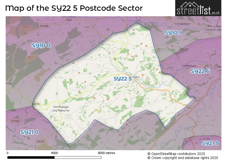
The SY22 5 Llanfyllin Postcode Sector
The SY22 5 postcode sector is within the county of Powys.
Did you know? According to the 2021 Census, the SY22 5 postcode sector is home to a bustling 2,120 residents!
Given that each sector allows for 400 unique postcode combinations. Letters C, I, K, M, O and V are not allowed in the last two letters of a postcode. With 112 postcodes already in use, this leaves 288 units available.
The largest settlement in the SY22 5 postal code is LLANFYLLIN followed by LLANFIHANGEL, and BWLCH-Y-CIBAU.
The SY22 5 Postcode shares a border with SY22 6 (LLANSANTFFRAID-YM-MECHAIN, LLANYMYNECH, MEIFOD), SY10 0 (LLANRHAEADR-YM-MOCHNANT, LLANGYNOG, LLANWDDYN), SY10 9 (Morda, Trefonen, Pant) and SY21 0 (LLANFAIR CAEREINION, LLANGADFAN, LLANERFYL).
Map of the SY22 5 Postcode Sector
Explore the SY22 5 postcode sector by using our interactive map.
The sector is within the post town of LLANFYLLIN.
SY22 5 is a postcode sector within the SY22 postcode district which is within the SY Shrewsbury postcode area.
The Royal Mail delivery office for the SY22 5 postal sector is the Llanfyllin Scale Payment Delivery Office.
The area of the SY22 5 postcode sector is 29.03 square miles which is 75.19 square kilometres or 18,579.20 square acres.
Your support helps keep this site running!
If you enjoy using this website, consider buying me a coffee to help cover hosting costs.


| S | Y | 2 | 2 | - | 5 | X | X |
| S | Y | 2 | 2 | Space | 5 | Letter | Letter |
Official List of Streets
LLANFYLLIN (27 Streets)
(3 Streets)
Unofficial Streets or Alternative Spellings
Weather Forecast for SY22 5
Weather Forecast for Llanfyllin
| Time Period | Icon | Description | Temperature | Rain Probability | Wind |
|---|---|---|---|---|---|
| 15:00 to 18:00 | Overcast | 4.0°C (feels like 1.0°C) | 8.00% | SE 9 mph | |
| 18:00 to 21:00 | Cloudy | 3.0°C (feels like 0.0°C) | 5.00% | ESE 7 mph | |
| 21:00 to 00:00 | Cloudy | 2.0°C (feels like -1.0°C) | 6.00% | ESE 7 mph |
| Time Period | Icon | Description | Temperature | Rain Probability | Wind |
|---|---|---|---|---|---|
| 00:00 to 03:00 | Cloudy | 1.0°C (feels like -2.0°C) | 6.00% | ESE 7 mph | |
| 03:00 to 06:00 | Cloudy | 1.0°C (feels like -2.0°C) | 6.00% | SE 7 mph | |
| 06:00 to 09:00 | Cloudy | 1.0°C (feels like -3.0°C) | 8.00% | SE 7 mph | |
| 09:00 to 12:00 | Cloudy | 2.0°C (feels like -2.0°C) | 7.00% | SE 9 mph | |
| 12:00 to 15:00 | Cloudy | 4.0°C (feels like 1.0°C) | 6.00% | SE 11 mph | |
| 15:00 to 18:00 | Cloudy | 6.0°C (feels like 3.0°C) | 5.00% | SE 11 mph | |
| 18:00 to 21:00 | Cloudy | 4.0°C (feels like 1.0°C) | 5.00% | SE 9 mph | |
| 21:00 to 00:00 | Cloudy | 3.0°C (feels like 0.0°C) | 5.00% | SE 9 mph |
| Time Period | Icon | Description | Temperature | Rain Probability | Wind |
|---|---|---|---|---|---|
| 00:00 to 03:00 | Cloudy | 2.0°C (feels like -1.0°C) | 5.00% | SSE 9 mph | |
| 03:00 to 06:00 | Cloudy | 2.0°C (feels like -2.0°C) | 5.00% | SSE 9 mph | |
| 06:00 to 09:00 | Cloudy | 2.0°C (feels like -2.0°C) | 5.00% | SSE 7 mph | |
| 09:00 to 12:00 | Cloudy | 4.0°C (feels like 0.0°C) | 7.00% | SSE 9 mph | |
| 12:00 to 15:00 | Cloudy | 7.0°C (feels like 4.0°C) | 7.00% | SSE 11 mph | |
| 15:00 to 18:00 | Cloudy | 9.0°C (feels like 6.0°C) | 6.00% | SSE 11 mph | |
| 18:00 to 21:00 | Cloudy | 8.0°C (feels like 5.0°C) | 5.00% | SSE 11 mph | |
| 21:00 to 00:00 | Overcast | 8.0°C (feels like 4.0°C) | 9.00% | S 11 mph |
| Time Period | Icon | Description | Temperature | Rain Probability | Wind |
|---|---|---|---|---|---|
| 00:00 to 03:00 | Cloudy | 8.0°C (feels like 5.0°C) | 7.00% | S 13 mph | |
| 03:00 to 06:00 | Overcast | 8.0°C (feels like 5.0°C) | 11.00% | S 13 mph | |
| 06:00 to 09:00 | Overcast | 9.0°C (feels like 6.0°C) | 10.00% | S 13 mph | |
| 09:00 to 12:00 | Overcast | 10.0°C (feels like 7.0°C) | 14.00% | S 16 mph | |
| 12:00 to 15:00 | Overcast | 12.0°C (feels like 9.0°C) | 15.00% | S 18 mph | |
| 15:00 to 18:00 | Overcast | 13.0°C (feels like 10.0°C) | 16.00% | SSW 18 mph | |
| 18:00 to 21:00 | Overcast | 11.0°C (feels like 9.0°C) | 13.00% | S 16 mph | |
| 21:00 to 00:00 | Overcast | 11.0°C (feels like 8.0°C) | 11.00% | S 16 mph |
House Prices in the SY22 5 Postcode Sector
| Type of Property | 2018 Average | 2018 Sales | 2017 Average | 2017 Sales | 2016 Average | 2016 Sales | 2015 Average | 2015 Sales |
|---|---|---|---|---|---|---|---|---|
| Detached | £282,409 | 11 | £273,923 | 13 | £263,608 | 18 | £243,000 | 7 |
| Semi-Detached | £84,950 | 1 | £112,667 | 3 | £160,333 | 3 | £138,317 | 3 |
| Terraced | £106,820 | 10 | £130,813 | 8 | £100,313 | 8 | £127,375 | 4 |
| Flats | £0 | 0 | £0 | 0 | £0 | 0 | £0 | 0 |
Important Postcodes SY22 5 in the Postcode Sector
SY22 5BJ is the postcode for Llanfyllin Primary School, Llanfyllin High School, Ysgol Gynradd Llanfyllin, and Llanfyllin Leisure Centre
SY22 5DB is the postcode for Montgomeryshire District Council
SY22 5DG is the postcode for Llanfyllin Group Practice, Llanfyllin Medical Centre, High Street
| The SY22 5 Sector is within these Local Authorities |
|
|---|---|
| The SY22 5 Sector is within these Counties |
|
| The SY22 5 Sector is within these Water Company Areas |
|