A wide range of spatial data has been analysed to present this overview of the ST16 3 Postcode sector. If you would like anything added, please contact us.
The ST16 3 postcode sector is within the county of Staffordshire.
Did you know? According to the 2021 Census, the ST16 3 postcode sector is home to a bustling 16,866 residents!
Given that each sector allows for 400 unique postcode combinations. Letters C, I, K, M, O and V are not allowed in the last two letters of a postcode. With 336 postcodes already in use, this leaves 64 units available.
The largest settlements in the ST16 3 postal code are STAFFORD and Tollgate Industrial Estate.
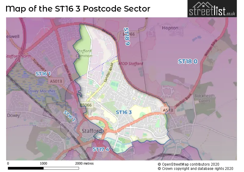
The ST16 3 Postcode shares a border with ST16 2 (STAFFORD), ST16 1 (STAFFORD), ST17 4 (STAFFORD), ST18 0 (STAFFORD, Great Haywood, Hixon) and ST18 9 (Haughton, Derrington, Seighford).
Map of the ST16 3 Postcode Sector
Explore the ST16 3 postcode sector by using our interactive map.
The sector is within the post town of STAFFORD.
ST16 3 is a postcode sector within the ST16 postcode district which is within the ST Stoke-on-Trent postcode area.
The Royal Mail delivery office for the ST16 3 postal sector is the Stafford Delivery Office.
The area of the ST16 3 postcode sector is 2.09 square miles which is 5.42 square kilometres or 1,338.67 square acres.
Waterways within the ST16 3 postcode sector include the River Sow, River Penk.
Your support helps keep this site running!
If you enjoy using this website, consider buying me a coffee to help cover hosting costs.


| S | T | 1 | 6 | - | 3 | X | X |
| S | T | 1 | 6 | Space | 3 | Letter | Letter |
Official List of Streets
STAFFORD (188 Streets)
Astonfields Industrial Estate (2 Streets)
Tollgate Industrial Estate (4 Streets)
Unofficial Streets or Alternative Spellings
STAFFORD
BRACKENFIELD WAY COUNTY ROAD EASTGATE STREET FOREGATE STREET GEORGE STREET ROWLEY STREET SALTER STREET SASH STREET SHERWOOD COURT CO-OPERATIVE STREET DAVIS CLOSE DORRINGTON DRIVE GAOL SQUARE HARECROFT ISABEL TRAIL KINGSTON CENTRE KINGSTON HILL COURT MARSH COURT MARSTON COURT PATON CLOSE PATON DRIVE PENNYCROFTS QUEENSWAY ISLAND SAINT ALBANS ROAD SAINT GEORGES PARKWAY SAINT PATRICKS STREET ST PATRICKS STREET ST. JOHNS WALK STANWAY COURT WATERSIDE PLACE WILLIAMS COURTTollgate Industrial Estate
BRUNEL CLOSEHopton
SANDON ROADWeather Forecast for ST16 3
Weather Forecast for Stafford
| Time Period | Icon | Description | Temperature | Rain Probability | Wind |
|---|---|---|---|---|---|
| 06:00 to 09:00 | Overcast | 4.0°C (feels like 3.0°C) | 10.00% | SE 4 mph | |
| 09:00 to 12:00 | Overcast | 5.0°C (feels like 2.0°C) | 9.00% | SSE 7 mph | |
| 12:00 to 15:00 | Overcast | 6.0°C (feels like 3.0°C) | 7.00% | S 9 mph | |
| 15:00 to 18:00 | Overcast | 7.0°C (feels like 4.0°C) | 8.00% | S 9 mph | |
| 18:00 to 21:00 | Overcast | 6.0°C (feels like 3.0°C) | 8.00% | SSE 9 mph | |
| 21:00 to 00:00 | Cloudy | 5.0°C (feels like 1.0°C) | 8.00% | SSE 11 mph |
| Time Period | Icon | Description | Temperature | Rain Probability | Wind |
|---|---|---|---|---|---|
| 00:00 to 03:00 | Overcast | 4.0°C (feels like 0.0°C) | 8.00% | SSE 11 mph | |
| 03:00 to 06:00 | Overcast | 4.0°C (feels like 0.0°C) | 9.00% | SSE 9 mph | |
| 06:00 to 09:00 | Cloudy | 3.0°C (feels like -1.0°C) | 7.00% | SSE 9 mph | |
| 09:00 to 12:00 | Cloudy | 3.0°C (feels like 0.0°C) | 8.00% | SSE 9 mph | |
| 12:00 to 15:00 | Cloudy | 6.0°C (feels like 3.0°C) | 7.00% | S 9 mph | |
| 15:00 to 18:00 | Cloudy | 7.0°C (feels like 4.0°C) | 8.00% | SSW 7 mph | |
| 18:00 to 21:00 | Cloudy | 5.0°C (feels like 3.0°C) | 5.00% | SSW 7 mph | |
| 21:00 to 00:00 | Partly cloudy (night) | 4.0°C (feels like 1.0°C) | 2.00% | SSW 7 mph |
| Time Period | Icon | Description | Temperature | Rain Probability | Wind |
|---|---|---|---|---|---|
| 00:00 to 03:00 | Cloudy | 4.0°C (feels like 1.0°C) | 5.00% | SSW 7 mph | |
| 03:00 to 06:00 | Overcast | 4.0°C (feels like 1.0°C) | 8.00% | SSW 7 mph | |
| 06:00 to 09:00 | Overcast | 4.0°C (feels like 1.0°C) | 8.00% | SSW 9 mph | |
| 09:00 to 12:00 | Overcast | 5.0°C (feels like 1.0°C) | 8.00% | SSW 9 mph | |
| 12:00 to 15:00 | Cloudy | 7.0°C (feels like 4.0°C) | 5.00% | SSW 11 mph | |
| 15:00 to 18:00 | Cloudy | 9.0°C (feels like 6.0°C) | 5.00% | SSW 11 mph | |
| 18:00 to 21:00 | Cloudy | 7.0°C (feels like 4.0°C) | 6.00% | S 11 mph | |
| 21:00 to 00:00 | Cloudy | 7.0°C (feels like 3.0°C) | 6.00% | S 11 mph |
| Time Period | Icon | Description | Temperature | Rain Probability | Wind |
|---|---|---|---|---|---|
| 00:00 to 03:00 | Overcast | 7.0°C (feels like 3.0°C) | 11.00% | S 13 mph | |
| 03:00 to 06:00 | Cloudy | 7.0°C (feels like 4.0°C) | 14.00% | SSW 13 mph | |
| 06:00 to 09:00 | Overcast | 7.0°C (feels like 4.0°C) | 19.00% | SSW 13 mph | |
| 09:00 to 12:00 | Overcast | 8.0°C (feels like 4.0°C) | 22.00% | SSW 13 mph | |
| 12:00 to 15:00 | Cloudy | 9.0°C (feels like 6.0°C) | 17.00% | SSW 13 mph | |
| 15:00 to 18:00 | Cloudy | 10.0°C (feels like 7.0°C) | 17.00% | SW 11 mph | |
| 18:00 to 21:00 | Cloudy | 8.0°C (feels like 5.0°C) | 13.00% | WSW 9 mph | |
| 21:00 to 00:00 | Partly cloudy (night) | 6.0°C (feels like 3.0°C) | 6.00% | WSW 9 mph |
Schools and Places of Education Within the ST16 3 Postcode Sector
John Wheeldon Primary Academy
Academy sponsor led
Corporation Street, Stafford, Staffordshire, ST16 3LX
Head: Mr Richard Sutton
Ofsted Rating: Good
Inspection: 2019-09-12 (1969 days ago)
Website: Visit John Wheeldon Primary Academy Website
Phone: 01785594444
Number of Pupils: 509
St John's CofE Primary Academy
Academy converter
Weston Road, Stafford, , ST16 3RZ
Head: Ms Victoria Evans
Ofsted Rating: Good
Inspection: 2019-06-26 (2047 days ago)
Website: Visit St John's CofE Primary Academy Website
Phone: 01785251960
Number of Pupils: 380
St Leonard's Primary School
Community school
Fairway, Stafford, , ST16 3TW
Head: Miss Karen Roberts
Ofsted Rating: Good
Inspection: 2019-09-26 (1955 days ago)
Website: Visit St Leonard's Primary School Website
Phone: 01785334960
Number of Pupils: 211
St Patrick's Catholic Primary School
Academy converter
St Patrick's Catholic Primary School & Nursery, Stafford, Staffordshire, ST16 3BT
Head: Mr Mark Brandon
Ofsted Rating: Good
Inspection: 2022-10-05 (850 days ago)
Website: Visit St Patrick's Catholic Primary School Website
Phone: 01785413275
Number of Pupils: 203
House Prices in the ST16 3 Postcode Sector
| Type of Property | 2018 Average | 2018 Sales | 2017 Average | 2017 Sales | 2016 Average | 2016 Sales | 2015 Average | 2015 Sales |
|---|---|---|---|---|---|---|---|---|
| Detached | £212,956 | 34 | £240,285 | 47 | £204,511 | 36 | £250,876 | 49 |
| Semi-Detached | £159,723 | 84 | £153,085 | 77 | £151,518 | 73 | £153,364 | 85 |
| Terraced | £138,453 | 116 | £141,554 | 135 | £141,642 | 152 | £121,024 | 141 |
| Flats | £131,145 | 82 | £128,465 | 65 | £121,079 | 42 | £106,153 | 35 |
Important Postcodes ST16 3 in the Postcode Sector
ST16 3AE is the postcode for South Staffordshire Healthcare NHS Trust, Central Clinic, North Walls
ST16 3AG is the postcode for HATHERTON CENTRE, Midlands Partnership NHS Foundation Trust, St. Georges Hospital (rre), MICHAEL FLANIGAN BUILDING, Midlands Partnership NHS Foundation Trust, St. Georges Hospital (rre), FOUNDATION HOUSE, Midlands Partnership NHS Foundation Trust, St. Georges Hospital (rre), TRUST HEADQUARTERS, Midlands Partnership NHS Foundation Trust, St. Georges Hospital (rre), NORBURY/STONEFIELD, Midlands Partnership NHS Foundation Trust, St. Georges Hospital (rre), NORBURY/STONEFIELD, Midlands Partnership NHS Foundation Trust, St. Georges Hospital, ST CHADS, Midlands Partnership NHS Foundation Trust, St. Georges Hospital (rre), MARSTON HOUSE, Midlands Partnership NHS Foundation Trust, St. Georges Hospital (rre), TRUST HEADQUARTERS, Midlands Partnership NHS Foundation Trust, St. Georges Hospita, LEARNING CENTRE, Midlands Partnership NHS Foundation Trust, St. Georges Hospital (rre), Midlands Partnership NHS Foundation Trust, St. Georges Hospital (rre), TRUST HEADQUARTERS, Midlands Partnership NHS Foundation Trust, St. Georges Hospital, BROCTON/CHEBSEY, Midlands Partnership NHS Foundation Trust, St. Georges Hospital (rre), ST CHADS, Midlands Partnership NHS Foundation Trust, St. Georges Hospital, GAYTON LODGE, Midlands Partnership NHS Foundation Trust, St. Georges Hospital (rre), and BROCTON/CHEBSEY, Midlands Partnership NHS Foundation Trust, St. Georges Hospital
ST16 3AQ is the postcode for Stafford Borough Council, Civic Centre, Riverside
ST16 3AW is the postcode for H M Prison, 54 Gaol Road
ST16 3BF is the postcode for Staffordshire and West Midlands Community Rehabilitation Company. National Probation Service, Dorrington Drive
ST16 3BH is the postcode for Stafford Day Service, Marsh Court, Marsh Street
ST16 3BL is the postcode for National Probation Service, South Walls
ST16 3BT is the postcode for Staffordshire County Council, St. Patricks RC Cp School, Marston Road, ST PATRICKS ROMAN CATHOLIC COUNTY PRIMARY SCHOOL, MARSTON ROAD, STAFFORD, and St Patricks Roman Catholic County Primary School, Marston Road
ST16 3BU is the postcode for Staffordshire County Council, The Foxwalls Residential Home, Marston Road
ST16 3DU is the postcode for The Northfield Centre, Magnolia Avenue
ST16 3DW is the postcode for South Staffordshire Magistrates Court, South Walls
ST16 3DX is the postcode for Unit 4 Romford Court, Drummond Road, Astonfields Industrial Estate, and Unit 4 Romford Court, Drummond Road
ST16 3EB is the postcode for Health And Wellbeing Centre, Whitgreave Court, and HEALTH AND WELLBEING CENTRE, WHITGREAVE COURT, STAFFORD
ST16 3HS is the postcode for West Midlands Ambulance Service, Unit 2, Tollgate Drive
ST16 3LX is the postcode for Staffordshire County Council, John Wheeldon Cp School, Corporation Street, NEW BLOCK, Staffordshire County Council, John Wheeldon Cp School, Corporation Street, Birch Building, John Wheeldon Primary Academy, Corporation Street, Staffordshire County Council, Corporation Street, and Elm Building, John Wheeldon Primary Academy, Corporation Street
ST16 3NE is the postcode for South Staffs Healthcare Foundation NHS Trust, Crooked Bridge Road
ST16 3NF is the postcode for Staffordshire County Council, Sandyford Street Complex, and ICT TRAINING CENTRE, Staffordshire County Council, Sandyford Street Complex
ST16 3NN is the postcode for Stafford Children's Centre, Faraday Road
ST16 3RL is the postcode for St. Johns C of E Cp School, Weston Road
ST16 3SA is the postcode for County Hospital, Weston Road, Mid Staffordshire NHS Foundation Trust, Staffordshire General Hospital, and Mid Staffordshire General Hospitals NHS Trust, Staffordshire General Hospital, Weston Road
ST16 3TA is the postcode for Freedom Leisure, Stafford Leisure Centre, Lammascote Road, and Stafford Leisure Centre, Lammascote Road
ST16 3TJ is the postcode for Staffordshire County Council, Riverway
ST16 3TW is the postcode for Staffordshire County Council, Kingston Resource & Development Centre, Fairway
| The ST16 3 Sector is within these Local Authorities |
|
|---|---|
| The ST16 3 Sector is within these Counties |
|
| The ST16 3 Sector is within these Water Company Areas |
|