A wide range of spatial data has been analysed to present this overview of the SS11 7 Postcode sector. If you would like anything added, please contact us.
The SS11 7 postcode sector is within the county of Essex.
Did you know? According to the 2021 Census, the SS11 7 postcode sector is home to a bustling 9,197 residents!
Given that each sector allows for 400 unique postcode combinations. Letters C, I, K, M, O and V are not allowed in the last two letters of a postcode. With 205 postcodes already in use, this leaves 195 units available.
The largest settlement in the SS11 7 postal code is WICKFORD followed by Runwell, and Battlesbridge.
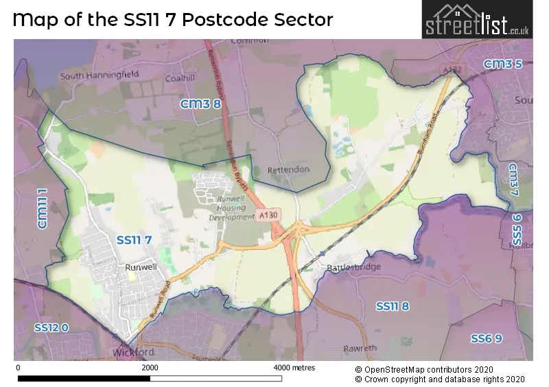
The SS11 7 Postcode shares a border with CM3 5 (South Woodham Ferrers), CM3 7 (South Woodham Ferrers), CM3 8 (Rettendon Common, East Hanningfield, Woodham Ferrers), SS11 8 (WICKFORD, Rawreth), SS12 0 (WICKFORD), SS12 9 (WICKFORD, North Benfleet) and CM11 1 (BILLERICAY, Ramsden Heath, Downham).
Map of the SS11 7 Postcode Sector
Explore the SS11 7 postcode sector by using our interactive map.
The sector is within the post town of WICKFORD.
SS11 7 is a postcode sector within the SS11 postcode district which is within the SS Southend-on-Sea postcode area.
The Royal Mail delivery office for the SS11 7 postal sector is the Wickford Delivery Office.
The area of the SS11 7 postcode sector is 5.98 square miles which is 15.49 square kilometres or 3,826.50 square acres.
Waterways within the SS11 7 postcode sector include the River Crouch, Fenn Creek.
Your support helps keep this site running!
If you enjoy using this website, consider buying me a coffee to help cover hosting costs.


| S | S | 1 | 1 | - | 7 | X | X |
| S | S | 1 | 1 | Space | 7 | Letter | Letter |
Official List of Streets
WICKFORD (62 Streets)
Runwell (44 Streets)
(8 Streets)
Battlesbridge (19 Streets)
Unofficial Streets or Alternative Spellings
Rettendon Common
MAIN ROAD SOUTH HANNINGFIELD ROAD WARREN ROADSouth Woodham Ferrers
WICKFORD ROAD CHURCH CHASE CURRY HILL FOOTBRIDGE HAWK HILL ROUNDABOUT PENRITH CLOSE POT KILN CLOSE RETTENDON BYPASS STROM OLSENRunwell
BONNELL CLOSEWICKFORD
GOLDEN JUBILEE WAY HIGH STREET LOWER SOUTHEND ROADDownham
GRANGE LANE HAWKSWOOD ROAD SUDBURY ROADWeather Forecast for SS11 7
Weather Forecast for Wickford
| Time Period | Icon | Description | Temperature | Rain Probability | Wind |
|---|---|---|---|---|---|
| 12:00 to 15:00 | Overcast | 10.0°C (feels like 6.0°C) | 9.00% | SW 18 mph | |
| 15:00 to 18:00 | Cloudy | 10.0°C (feels like 6.0°C) | 6.00% | SW 18 mph | |
| 18:00 to 21:00 | Cloudy | 10.0°C (feels like 7.0°C) | 7.00% | SW 20 mph | |
| 21:00 to 00:00 | Cloudy | 11.0°C (feels like 7.0°C) | 8.00% | SW 20 mph |
| Time Period | Icon | Description | Temperature | Rain Probability | Wind |
|---|---|---|---|---|---|
| 00:00 to 03:00 | Overcast | 11.0°C (feels like 8.0°C) | 15.00% | SW 20 mph | |
| 03:00 to 06:00 | Overcast | 11.0°C (feels like 8.0°C) | 16.00% | SW 18 mph | |
| 06:00 to 09:00 | Overcast | 11.0°C (feels like 8.0°C) | 22.00% | SW 18 mph | |
| 09:00 to 12:00 | Overcast | 11.0°C (feels like 8.0°C) | 22.00% | SW 16 mph | |
| 12:00 to 15:00 | Light rain | 11.0°C (feels like 7.0°C) | 54.00% | SW 20 mph | |
| 15:00 to 18:00 | Heavy rain | 11.0°C (feels like 7.0°C) | 85.00% | SW 22 mph | |
| 18:00 to 21:00 | Heavy rain | 10.0°C (feels like 6.0°C) | 89.00% | WSW 20 mph | |
| 21:00 to 00:00 | Heavy rain | 8.0°C (feels like 4.0°C) | 76.00% | W 18 mph |
| Time Period | Icon | Description | Temperature | Rain Probability | Wind |
|---|---|---|---|---|---|
| 00:00 to 03:00 | Cloudy | 6.0°C (feels like 2.0°C) | 22.00% | NW 11 mph | |
| 03:00 to 06:00 | Cloudy | 4.0°C (feels like 1.0°C) | 13.00% | NW 9 mph | |
| 06:00 to 09:00 | Cloudy | 3.0°C (feels like 0.0°C) | 7.00% | NW 9 mph | |
| 09:00 to 12:00 | Cloudy | 2.0°C (feels like -1.0°C) | 5.00% | NW 7 mph | |
| 12:00 to 15:00 | Sunny day | 4.0°C (feels like 1.0°C) | 2.00% | NNW 9 mph | |
| 15:00 to 18:00 | Sunny day | 4.0°C (feels like 1.0°C) | 3.00% | NNW 7 mph | |
| 18:00 to 21:00 | Clear night | 2.0°C (feels like -1.0°C) | 3.00% | NNW 7 mph | |
| 21:00 to 00:00 | Clear night | 1.0°C (feels like -2.0°C) | 2.00% | NNW 7 mph |
| Time Period | Icon | Description | Temperature | Rain Probability | Wind |
|---|---|---|---|---|---|
| 00:00 to 03:00 | Clear night | 0.0°C (feels like -3.0°C) | 1.00% | NNW 7 mph | |
| 03:00 to 06:00 | Clear night | 0.0°C (feels like -4.0°C) | 1.00% | NNW 7 mph | |
| 06:00 to 09:00 | Clear night | -1.0°C (feels like -4.0°C) | 1.00% | NW 7 mph | |
| 09:00 to 12:00 | Sunny day | -1.0°C (feels like -4.0°C) | 1.00% | NW 7 mph | |
| 12:00 to 15:00 | Sunny day | 2.0°C (feels like -1.0°C) | 1.00% | WNW 7 mph | |
| 15:00 to 18:00 | Sunny day | 3.0°C (feels like 0.0°C) | 1.00% | WNW 7 mph | |
| 18:00 to 21:00 | Clear night | 1.0°C (feels like -2.0°C) | 2.00% | W 7 mph | |
| 21:00 to 00:00 | Clear night | 0.0°C (feels like -3.0°C) | 2.00% | W 7 mph |
Schools and Places of Education Within the SS11 7 Postcode Sector
Children's Support Service
Pupil referral unit
Alderney Gardens, Wickford, Essex, SS11 7JZ
Head: Mrs Jo Barak
Ofsted Rating: Good
Inspection: 2023-05-11 (600 days ago)
Website: Visit Children's Support Service Website
Phone: 07872107964
Number of Pupils: 58
Runwell Community Primary School
Academy converter
Canewdon Gardens, Wickford, Essex, SS11 7BJ
Head: Mrs Rachel Anthony
Ofsted Rating: Good
Inspection: 2023-07-19 (531 days ago)
Website: Visit Runwell Community Primary School Website
Phone: 01268735329
Number of Pupils: 404
House Prices in the SS11 7 Postcode Sector
| Type of Property | 2018 Average | 2018 Sales | 2017 Average | 2017 Sales | 2016 Average | 2016 Sales | 2015 Average | 2015 Sales |
|---|---|---|---|---|---|---|---|---|
| Detached | £546,228 | 95 | £502,670 | 76 | £476,461 | 65 | £382,189 | 43 |
| Semi-Detached | £357,854 | 43 | £340,022 | 46 | £309,522 | 68 | £268,148 | 61 |
| Terraced | £351,299 | 30 | £311,526 | 19 | £273,359 | 32 | £231,275 | 20 |
| Flats | £167,045 | 11 | £160,419 | 19 | £158,296 | 32 | £96,195 | 10 |
Important Postcodes SS11 7 in the Postcode Sector
SS11 7BJ is the postcode for MAIN BUILDING, Runwell Community Primary School Academy Trust, Canewdon Gardens
SS11 7FE is the postcode for Brockfield House, Kemble Way
SS11 7JZ is the postcode for A I S Wickford Centre, Alderney Gardens
SS11 7XX is the postcode for South Essex Partnership NHS Foundation Trust, Runwell Hospital, The Lodge, Runwell Chase, and The Lodge, Runwell Chase, Runwell
| The SS11 7 Sector is within these Local Authorities |
|
|---|---|
| The SS11 7 Sector is within these Counties |
|
| The SS11 7 Sector is within these Water Company Areas |
|