A wide range of spatial data has been analysed to present this overview of the SP4 7 Postcode sector. If you would like anything added, please contact us.
The SP4 7 postcode sector is within the county of Wiltshire.
Did you know? According to the 2021 Census, the SP4 7 postcode sector is home to a bustling 13,041 residents!
Given that each sector allows for 400 unique postcode combinations. Letters C, I, K, M, O and V are not allowed in the last two letters of a postcode. With 324 postcodes already in use, this leaves 76 units available.
The SP4 7 postal code covers the settlement of Amesbury.
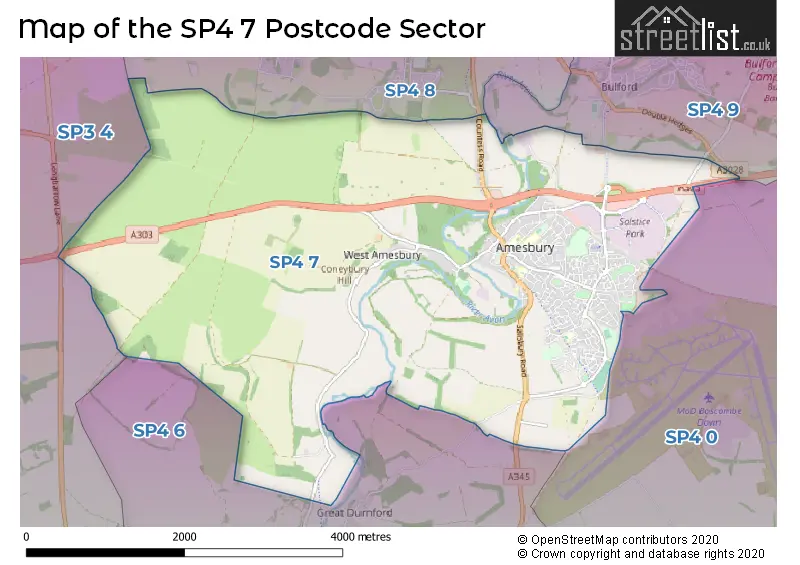
The SP4 7 Postcode shares a border with SP3 4 (Shrewton, Barford St. Martin, Tilshead), SP4 0 (Porton, Cholderton, Newton Toney), SP4 6 (Old Sarum, Longhedge, Gomeldon), SP4 8 (Durrington, Larkhill, Figheldean) and SP4 9 (Bulford, Bulford Barracks, Netheravon).
Map of the SP4 7 Postcode Sector
Explore the SP4 7 postcode sector by using our interactive map.
The sector is within the post town of SALISBURY.
SP4 7 is a postcode sector within the SP4 postcode district which is within the SP Salisbury postcode area.
The Royal Mail delivery office for the SP4 7 postal sector is the Amesbury Delivery Office.
The area of the SP4 7 postcode sector is 10.24 square miles which is 26.52 square kilometres or 6,553.89 square acres.
The SP4 7 postcode sector is crossed by the A303 Major A road.
Waterways within the SP4 7 postcode sector include the River Avon.
Your support helps keep this site running!
If you enjoy using this website, consider buying me a coffee to help cover hosting costs.


| S | P | 4 | - | 7 | X | X |
| S | P | 4 | Space | 7 | Letter | Letter |
Official List of Streets
Amesbury (223 Streets)
(20 Streets)
West Amesbury (2 Streets)
Lake (1 Streets)
Unofficial Streets or Alternative Spellings
Allington
ALLINGTON TRACKBulford Barracks
AMESBURY ROADBulford
SALISBURY ROADWeather Forecast for SP4 7
Weather Forecast for Amesbury
| Time Period | Icon | Description | Temperature | Rain Probability | Wind |
|---|---|---|---|---|---|
| 00:00 to 03:00 | Cloudy | 7.0°C (feels like 4.0°C) | 5.00% | SSW 9 mph | |
| 03:00 to 06:00 | Cloudy | 8.0°C (feels like 5.0°C) | 8.00% | SSW 11 mph | |
| 06:00 to 09:00 | Cloudy | 8.0°C (feels like 5.0°C) | 5.00% | SSW 11 mph | |
| 09:00 to 12:00 | Overcast | 8.0°C (feels like 5.0°C) | 9.00% | SSW 13 mph | |
| 12:00 to 15:00 | Cloudy | 10.0°C (feels like 7.0°C) | 9.00% | SSW 16 mph | |
| 15:00 to 18:00 | Light rain | 10.0°C (feels like 6.0°C) | 88.00% | SSW 16 mph | |
| 18:00 to 21:00 | Heavy rain shower (night) | 9.0°C (feels like 6.0°C) | 91.00% | WSW 9 mph | |
| 21:00 to 00:00 | Clear night | 7.0°C (feels like 4.0°C) | 5.00% | WSW 9 mph |
| Time Period | Icon | Description | Temperature | Rain Probability | Wind |
|---|---|---|---|---|---|
| 00:00 to 03:00 | Clear night | 5.0°C (feels like 2.0°C) | 0.00% | WSW 7 mph | |
| 03:00 to 06:00 | Clear night | 4.0°C (feels like 1.0°C) | 0.00% | WSW 7 mph | |
| 06:00 to 09:00 | Clear night | 3.0°C (feels like 1.0°C) | 1.00% | W 7 mph | |
| 09:00 to 12:00 | Cloudy | 4.0°C (feels like 2.0°C) | 4.00% | W 7 mph | |
| 12:00 to 15:00 | Cloudy | 8.0°C (feels like 6.0°C) | 5.00% | WNW 7 mph | |
| 15:00 to 18:00 | Cloudy | 8.0°C (feels like 7.0°C) | 5.00% | NW 7 mph | |
| 18:00 to 21:00 | Cloudy | 4.0°C (feels like 3.0°C) | 4.00% | N 4 mph | |
| 21:00 to 00:00 | Partly cloudy (night) | 3.0°C (feels like 1.0°C) | 1.00% | NNE 4 mph |
| Time Period | Icon | Description | Temperature | Rain Probability | Wind |
|---|---|---|---|---|---|
| 00:00 to 03:00 | Partly cloudy (night) | 2.0°C (feels like 0.0°C) | 1.00% | NNE 7 mph | |
| 03:00 to 06:00 | Clear night | 2.0°C (feels like -1.0°C) | 1.00% | NE 7 mph | |
| 06:00 to 09:00 | Clear night | 1.0°C (feels like -2.0°C) | 1.00% | NE 7 mph | |
| 09:00 to 12:00 | Sunny day | 2.0°C (feels like -1.0°C) | 0.00% | ENE 9 mph | |
| 12:00 to 15:00 | Sunny day | 6.0°C (feels like 4.0°C) | 1.00% | ENE 9 mph | |
| 15:00 to 18:00 | Sunny day | 7.0°C (feels like 4.0°C) | 1.00% | ENE 11 mph | |
| 18:00 to 21:00 | Clear night | 4.0°C (feels like 1.0°C) | 1.00% | ENE 9 mph | |
| 21:00 to 00:00 | Clear night | 3.0°C (feels like -1.0°C) | 1.00% | ENE 9 mph |
| Time Period | Icon | Description | Temperature | Rain Probability | Wind |
|---|---|---|---|---|---|
| 00:00 to 03:00 | Clear night | 2.0°C (feels like -2.0°C) | 1.00% | ENE 9 mph | |
| 03:00 to 06:00 | Partly cloudy (night) | 2.0°C (feels like -2.0°C) | 2.00% | NE 9 mph | |
| 06:00 to 09:00 | Mist | 1.0°C (feels like -3.0°C) | 13.00% | NE 9 mph | |
| 09:00 to 12:00 | Cloudy | 2.0°C (feels like -2.0°C) | 5.00% | NE 11 mph | |
| 12:00 to 15:00 | Partly cloudy (day) | 5.0°C (feels like 1.0°C) | 2.00% | ENE 11 mph | |
| 15:00 to 18:00 | Sunny day | 6.0°C (feels like 2.0°C) | 2.00% | NE 11 mph | |
| 18:00 to 21:00 | Clear night | 3.0°C (feels like 0.0°C) | 2.00% | NE 9 mph | |
| 21:00 to 00:00 | Clear night | 2.0°C (feels like -1.0°C) | 2.00% | NE 9 mph |
Schools and Places of Education Within the SP4 7 Postcode Sector
Amesbury Archer Primary School
Academy converter
Shears Drive, Amesbury, Wiltshire, SP4 7XX
Head: Mr David Webber
Ofsted Rating: Good
Inspection: 2021-06-10 (1335 days ago)
Website: Visit Amesbury Archer Primary School Website
Phone: 01980625944
Number of Pupils: 412
King's Gate Primary School
Free schools
Great Amber Way, Salisbury, , SP4 7GD
Head: Mrs Sasha Owen
Ofsted Rating: Good
Inspection: 2023-11-08 (454 days ago)
Website: Visit King's Gate Primary School Website
Phone: 01980669777
Number of Pupils: 153
The Stonehenge School
Community school
Holders Road, Amesbury, Wiltshire, SP4 7PW
Head: Mrs Carole Dean
Ofsted Rating: Good
Inspection: 2022-09-22 (866 days ago)
Website: Visit The Stonehenge School Website
Phone: 01980623407
Number of Pupils: 1019
House Prices in the SP4 7 Postcode Sector
| Type of Property | 2018 Average | 2018 Sales | 2017 Average | 2017 Sales | 2016 Average | 2016 Sales | 2015 Average | 2015 Sales |
|---|---|---|---|---|---|---|---|---|
| Detached | £354,643 | 96 | £334,913 | 105 | £310,522 | 100 | £336,936 | 88 |
| Semi-Detached | £248,149 | 65 | £242,692 | 76 | £233,505 | 109 | £212,942 | 70 |
| Terraced | £233,158 | 47 | £224,938 | 52 | £209,048 | 79 | £202,220 | 70 |
| Flats | £151,484 | 16 | £147,798 | 30 | £180,641 | 27 | £183,561 | 54 |
Important Postcodes SP4 7 in the Postcode Sector
SP4 7AL is the postcode for Wiltshire Council, Amesbury Library, Smithfield Street
SP4 7AN is the postcode for Amesbury Health Centre, Smithfield Street
SP4 7AX is the postcode for Amesbury C Of E Primary School, Kitchener Road, KS2 BLOCK, Amesbury C E Controlled Primary School, Kitchener Road, and Amesbury C E Controlled Primary School, Kitchener Road
SP4 7DL is the postcode for The Barcroft Medical Centre, High Street
SP4 7HL is the postcode for Wiltshire Fire Brigade, Fire Station, 20 Salisbury Road
SP4 7LT is the postcode for The New Surgery, St. Melor House, Edwards Road
SP4 7LX is the postcode for Christ the King School, Earls Court Road
SP4 7ND is the postcode for UPPER SCHOOL, The Stonehenge School, Antrobus Road, LOWER SCHOOL, The Stonehenge School, Antrobus Road, and AMESBURY SPORTS CENTRE, The Stonehenge School, Antrobus Road
SP4 7PW is the postcode for Amesbury Sports & Community Centre, Holders Road, and Amesbury Sports And Community Centre, Holders Road
SP4 7XX is the postcode for Amesbury Archer School, Shears Drive
| The SP4 7 Sector is within these Local Authorities |
|
|---|---|
| The SP4 7 Sector is within these Counties |
|
| The SP4 7 Sector is within these Water Company Areas |
|
Tourist Attractions within the SP4 7 Postcode Area
We found 2 visitor attractions within the SP4 postcode area
| Stonehenge |
|---|
| Historic Properties |
| Historic Monument / Archaeological Site |
| View Stonehenge on Google Maps |
| Amesbury History Centre |
| Visitor Centres |
| Heritage / Visitor Centre |
| View Amesbury History Centre on Google Maps |