A wide range of spatial data has been analysed to present this overview of the SN8 3 Postcode sector. If you would like anything added, please contact us.
The SN8 3 postcode sector lies where the three counties of Hampshire, Wiltshire, and Berkshire meet.
Did you know? According to the 2021 Census, the SN8 3 postcode sector is home to a bustling 7,186 residents!
Given that each sector allows for 400 unique postcode combinations. Letters C, I, K, M, O and V are not allowed in the last two letters of a postcode. With 282 postcodes already in use, this leaves 118 units available.
The largest settlement in the SN8 3 postal code is Burbage followed by Great Bedwyn, and Collingbourne Ducis.
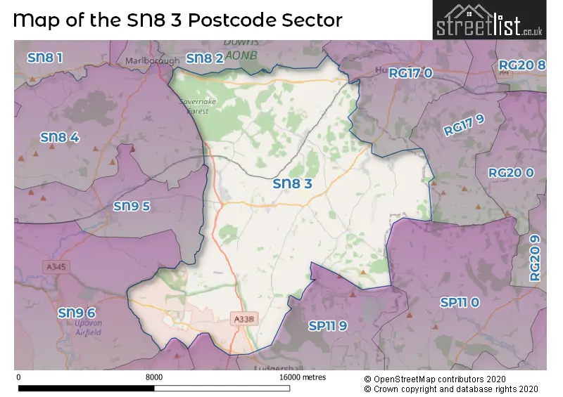
The SN8 3 Postcode shares a border with SP11 9 (Ludgershall, Perham Down, Appleshaw), RG17 0 (HUNGERFORD, Chilton Foliat, Eddington), RG17 9 (Kintbury, Inkpen, Combe), SN8 2 (Ramsbury, Aldbourne, MARLBOROUGH), SN8 4 (MARLBOROUGH, West Overton, Oare), SN9 5 (PEWSEY, Milton Lilbourne, Woodborough), SN9 6 (Upavon, Enford, Manningford Bruce), SP11 0 (Weyhill, Hurstbourne Tarrant, Vernham Dean), SP4 9 (Bulford, Bulford Barracks, Netheravon) and SP9 7 (TIDWORTH, Shipton Bellinger).
Map of the SN8 3 Postcode Sector
Explore the SN8 3 postcode sector by using our interactive map.
The sector is within the post town of MARLBOROUGH.
SN8 3 is a postcode sector within the SN8 postcode district which is within the SN Swindon postcode area.
The Royal Mail delivery office for the SN8 3 postal sector is the Marlborough Delivery Office and Burbage Scale Payment Delivery Office.
The area of the SN8 3 postcode sector is 68.90 square miles which is 178.46 square kilometres or 44,099.01 square acres.
Waterways within the SN8 3 postcode sector include the Kennet & Avon Canal.
Your support helps keep this site running!
If you enjoy using this website, consider buying me a coffee to help cover hosting costs.

| S | N | 8 | - | 3 | X | X |
| S | N | 8 | Space | 3 | Letter | Letter |
Official List of Streets
Burbage (41 Streets)
(40 Streets)
Collingbourne Kingston (6 Streets)
Great Bedwyn (25 Streets)
East Grafton (9 Streets)
Collingbourne Ducis (19 Streets)
Shalbourne (12 Streets)
Ham (2 Streets)
Little Bedwyn (4 Streets)
Wilton (3 Streets)
MARLBOROUGH (2 Streets)
Froxfield (7 Streets)
Everleigh (2 Streets)
Chisbury (2 Streets)
Buttermere (1 Streets)
Savernake (4 Streets)
Oxenwood (1 Streets)
Unofficial Streets or Alternative Spellings
Burbage
COOMB MEADOW THE RYSEFORDSMARLBOROUGH
LONDON ROADTIDWORTH
COLLINGBOURNE ROADHUNGERFORD
BATH ROAD CUTTING HILLNorth Standen
NORTH STANDEN ROADGreat Bedwyn
RAILWAY TERRACEWeather Forecast for SN8 3
Weather Forecast for Pewsey
| Time Period | Icon | Description | Temperature | Rain Probability | Wind |
|---|---|---|---|---|---|
| 03:00 to 06:00 | Overcast | 4.0°C (feels like 3.0°C) | 9.00% | ESE 4 mph | |
| 06:00 to 09:00 | Overcast | 4.0°C (feels like 2.0°C) | 10.00% | ESE 4 mph | |
| 09:00 to 12:00 | Cloudy | 4.0°C (feels like 2.0°C) | 8.00% | SE 7 mph | |
| 12:00 to 15:00 | Overcast | 6.0°C (feels like 3.0°C) | 8.00% | SSE 9 mph | |
| 15:00 to 18:00 | Overcast | 6.0°C (feels like 3.0°C) | 9.00% | SSE 9 mph | |
| 18:00 to 21:00 | Overcast | 5.0°C (feels like 2.0°C) | 9.00% | SSE 9 mph | |
| 21:00 to 00:00 | Cloudy | 4.0°C (feels like 0.0°C) | 4.00% | SSE 9 mph |
| Time Period | Icon | Description | Temperature | Rain Probability | Wind |
|---|---|---|---|---|---|
| 00:00 to 03:00 | Cloudy | 3.0°C (feels like 0.0°C) | 3.00% | SSE 7 mph | |
| 03:00 to 06:00 | Partly cloudy (night) | 2.0°C (feels like -1.0°C) | 1.00% | SSE 9 mph | |
| 06:00 to 09:00 | Cloudy | 2.0°C (feels like -1.0°C) | 5.00% | SSE 7 mph | |
| 09:00 to 12:00 | Partly cloudy (day) | 3.0°C (feels like 0.0°C) | 5.00% | SSE 7 mph | |
| 12:00 to 15:00 | Partly cloudy (day) | 6.0°C (feels like 3.0°C) | 4.00% | S 9 mph | |
| 15:00 to 18:00 | Sunny day | 7.0°C (feels like 4.0°C) | 3.00% | S 7 mph | |
| 18:00 to 21:00 | Clear night | 3.0°C (feels like 1.0°C) | 3.00% | SSW 4 mph | |
| 21:00 to 00:00 | Clear night | 2.0°C (feels like -1.0°C) | 2.00% | S 4 mph |
| Time Period | Icon | Description | Temperature | Rain Probability | Wind |
|---|---|---|---|---|---|
| 00:00 to 03:00 | Clear night | 1.0°C (feels like -1.0°C) | 2.00% | SSW 4 mph | |
| 03:00 to 06:00 | Partly cloudy (night) | 1.0°C (feels like -1.0°C) | 4.00% | S 4 mph | |
| 06:00 to 09:00 | Mist | 2.0°C (feels like -1.0°C) | 15.00% | S 7 mph | |
| 09:00 to 12:00 | Mist | 3.0°C (feels like 0.0°C) | 16.00% | S 7 mph | |
| 12:00 to 15:00 | Cloudy | 7.0°C (feels like 4.0°C) | 5.00% | S 11 mph | |
| 15:00 to 18:00 | Cloudy | 8.0°C (feels like 6.0°C) | 5.00% | SSW 11 mph | |
| 18:00 to 21:00 | Cloudy | 6.0°C (feels like 3.0°C) | 6.00% | S 9 mph | |
| 21:00 to 00:00 | Cloudy | 6.0°C (feels like 3.0°C) | 7.00% | S 11 mph |
| Time Period | Icon | Description | Temperature | Rain Probability | Wind |
|---|---|---|---|---|---|
| 00:00 to 03:00 | Partly cloudy (night) | 6.0°C (feels like 2.0°C) | 8.00% | S 11 mph | |
| 03:00 to 06:00 | Cloudy | 6.0°C (feels like 2.0°C) | 11.00% | S 11 mph | |
| 06:00 to 09:00 | Cloudy | 6.0°C (feels like 3.0°C) | 12.00% | S 11 mph | |
| 09:00 to 12:00 | Overcast | 7.0°C (feels like 4.0°C) | 21.00% | S 13 mph | |
| 12:00 to 15:00 | Overcast | 9.0°C (feels like 6.0°C) | 25.00% | SSW 16 mph | |
| 15:00 to 18:00 | Light rain | 9.0°C (feels like 7.0°C) | 53.00% | SW 13 mph | |
| 18:00 to 21:00 | Heavy rain | 8.0°C (feels like 5.0°C) | 68.00% | SW 9 mph | |
| 21:00 to 00:00 | Light rain | 7.0°C (feels like 4.0°C) | 43.00% | WSW 9 mph |
Schools and Places of Education Within the SN8 3 Postcode Sector
Burbage Primary School
Academy sponsor led
Blackmans Lane, Marlborough, Wiltshire, SN8 3TP
Head: Mrs Zoe Garbutt
Ofsted Rating: Good
Inspection: 2021-11-18 (1171 days ago)
Website: Visit Burbage Primary School Website
Phone: 01672810452
Number of Pupils: 176
Collingbourne Church of England Primary School
Voluntary controlled school
Chicks Lane, Marlborough, Wiltshire, SN8 3UH
Head: Mrs Harriet Phillips
Ofsted Rating: Good
Inspection: 2019-06-06 (2067 days ago)
Website: Visit Collingbourne Church of England Primary School Website
Phone: 01264850346
Number of Pupils: 95
Shalbourne CofE Primary School
Voluntary controlled school
Shalbourne, Shalbourne , Marlborough, Wiltshire, SN8 3QH
Head: Mrs Sara Slade
Ofsted Rating: Good
Inspection: 2022-11-10 (814 days ago)
Website: Visit Shalbourne CofE Primary School Website
Phone: 01672870475
Number of Pupils: 30
St Katharine's CofE Primary School
Academy converter
Savernake Forest, Marlborough, Wiltshire, SN8 3BG
Head: Ms Niki Jones
Ofsted Rating: Good
Inspection: 2021-12-07 (1152 days ago)
Website: Visit St Katharine's CofE Primary School Website
Phone: 01672870492
Number of Pupils: 95
House Prices in the SN8 3 Postcode Sector
| Type of Property | 2018 Average | 2018 Sales | 2017 Average | 2017 Sales | 2016 Average | 2016 Sales | 2015 Average | 2015 Sales |
|---|---|---|---|---|---|---|---|---|
| Detached | £605,694 | 44 | £552,840 | 87 | £615,206 | 69 | £583,044 | 64 |
| Semi-Detached | £375,269 | 18 | £401,727 | 22 | £402,641 | 32 | £348,112 | 21 |
| Terraced | £270,292 | 17 | £289,375 | 20 | £276,159 | 28 | £260,622 | 18 |
| Flats | £132,500 | 3 | £161,250 | 4 | £130,500 | 4 | £127,500 | 2 |
Important Postcodes SN8 3 in the Postcode Sector
SN8 3BG is the postcode for St. Katharines Primary School, St. Katharines
SN8 3HL is the postcode for SAVERNAKE COMMUNITY HOSPITAL, MAURICE WAY, MARLBOROUGH, and Savernake Hospital
SN8 3TP is the postcode for Burbage Cp School, Blackmans Lane
SN8 3UH is the postcode for Collingbourne Ducis Primary School, Chicks Lane
| The SN8 3 Sector is within these Local Authorities |
|
|---|---|
| The SN8 3 Sector is within these Counties |
|
| The SN8 3 Sector is within these Water Company Areas |
|