A wide range of spatial data has been analysed to present this overview of the SN16 0 Postcode sector. If you would like anything added, please contact us.
The SN16 0 postcode sector stands on the Gloucestershire and Wiltshire border.
Did you know? According to the 2021 Census, the SN16 0 postcode sector is home to a bustling 6,246 residents!
Given that each sector allows for 400 unique postcode combinations. Letters C, I, K, M, O and V are not allowed in the last two letters of a postcode. With 207 postcodes already in use, this leaves 193 units available.
The largest settlement in the SN16 0 postal code is MALMESBURY followed by Sherston, and Corston.
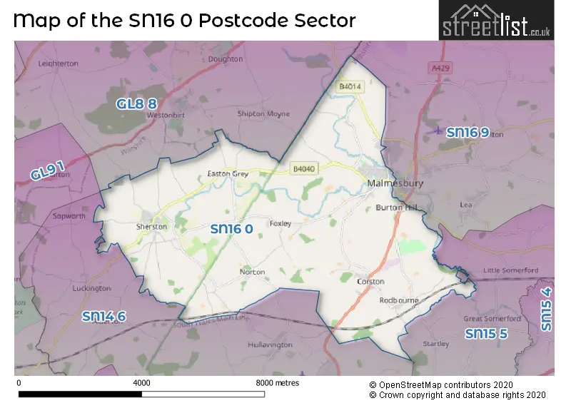
The SN16 0 Postcode shares a border with SN14 6 (CHIPPENHAM, Hullavington, Kington St. Michael), SN15 5 (Brinkworth, Kington Langley, Great Somerford), SN16 9 (MALMESBURY, Minety, Crudwell), GL8 8 (TETBURY, Avening, Westonbirt) and GL9 1 (Hawkesbury Upton, BADMINTON, Acton Turville).
Map of the SN16 0 Postcode Sector
Explore the SN16 0 postcode sector by using our interactive map.
The sector is within the post town of MALMESBURY.
SN16 0 is a postcode sector within the SN16 postcode district which is within the SN Swindon postcode area.
The Royal Mail delivery office for the SN16 0 postal sector is the Malmesbury Delivery Office.
The area of the SN16 0 postcode sector is 22.65 square miles which is 58.65 square kilometres or 14,493.90 square acres.
Your support helps keep this site running!
If you enjoy using this website, consider buying me a coffee to help cover hosting costs.


| S | N | 1 | 6 | - | 0 | X | X |
| S | N | 1 | 6 | Space | 0 | Letter | Letter |
Official List of Streets
MALMESBURY (63 Streets)
(24 Streets)
Sherston (34 Streets)
Corston (10 Streets)
Norton (1 Streets)
Rodbourne (1 Streets)
Pinkney (1 Streets)
Brokenborough (1 Streets)
Unofficial Streets or Alternative Spellings
MALMESBURY
AVON EDGE BEUTTELL WAY EXTON CLOSE SIR BERNARD LOVELL ROADWeather Forecast for SN16 0
Weather Forecast for Malmesbury
| Time Period | Icon | Description | Temperature | Rain Probability | Wind |
|---|---|---|---|---|---|
| 12:00 to 15:00 | Partly cloudy (day) | 6.0°C (feels like 3.0°C) | 0.00% | S 9 mph | |
| 15:00 to 18:00 | Cloudy | 7.0°C (feels like 4.0°C) | 4.00% | S 9 mph | |
| 18:00 to 21:00 | Cloudy | 5.0°C (feels like 3.0°C) | 5.00% | S 4 mph | |
| 21:00 to 00:00 | Cloudy | 4.0°C (feels like 2.0°C) | 5.00% | S 4 mph |
| Time Period | Icon | Description | Temperature | Rain Probability | Wind |
|---|---|---|---|---|---|
| 00:00 to 03:00 | Overcast | 4.0°C (feels like 2.0°C) | 9.00% | S 7 mph | |
| 03:00 to 06:00 | Overcast | 5.0°C (feels like 3.0°C) | 10.00% | S 4 mph | |
| 06:00 to 09:00 | Mist | 5.0°C (feels like 3.0°C) | 17.00% | S 7 mph | |
| 09:00 to 12:00 | Overcast | 7.0°C (feels like 4.0°C) | 17.00% | S 7 mph | |
| 12:00 to 15:00 | Cloudy | 9.0°C (feels like 6.0°C) | 9.00% | SW 11 mph | |
| 15:00 to 18:00 | Cloudy | 10.0°C (feels like 8.0°C) | 8.00% | SW 9 mph | |
| 18:00 to 21:00 | Cloudy | 7.0°C (feels like 5.0°C) | 8.00% | SSW 9 mph | |
| 21:00 to 00:00 | Cloudy | 7.0°C (feels like 4.0°C) | 5.00% | SSW 11 mph |
| Time Period | Icon | Description | Temperature | Rain Probability | Wind |
|---|---|---|---|---|---|
| 00:00 to 03:00 | Cloudy | 7.0°C (feels like 4.0°C) | 5.00% | SSW 11 mph | |
| 03:00 to 06:00 | Cloudy | 7.0°C (feels like 3.0°C) | 5.00% | SSW 13 mph | |
| 06:00 to 09:00 | Cloudy | 7.0°C (feels like 4.0°C) | 5.00% | SSW 13 mph | |
| 09:00 to 12:00 | Cloudy | 8.0°C (feels like 4.0°C) | 8.00% | SSW 16 mph | |
| 12:00 to 15:00 | Overcast | 10.0°C (feels like 7.0°C) | 24.00% | SSW 18 mph | |
| 15:00 to 18:00 | Heavy rain | 10.0°C (feels like 7.0°C) | 88.00% | SSW 16 mph | |
| 18:00 to 21:00 | Heavy rain | 9.0°C (feels like 6.0°C) | 80.00% | WSW 11 mph | |
| 21:00 to 00:00 | Clear night | 7.0°C (feels like 4.0°C) | 6.00% | WSW 11 mph |
| Time Period | Icon | Description | Temperature | Rain Probability | Wind |
|---|---|---|---|---|---|
| 00:00 to 03:00 | Clear night | 6.0°C (feels like 2.0°C) | 1.00% | WSW 9 mph | |
| 03:00 to 06:00 | Clear night | 4.0°C (feels like 1.0°C) | 1.00% | WSW 7 mph | |
| 06:00 to 09:00 | Clear night | 3.0°C (feels like 0.0°C) | 1.00% | WSW 7 mph | |
| 09:00 to 12:00 | Cloudy | 4.0°C (feels like 1.0°C) | 4.00% | WSW 4 mph | |
| 12:00 to 15:00 | Cloudy | 7.0°C (feels like 6.0°C) | 4.00% | W 7 mph | |
| 15:00 to 18:00 | Cloudy | 8.0°C (feels like 6.0°C) | 4.00% | NW 7 mph | |
| 18:00 to 21:00 | Partly cloudy (night) | 4.0°C (feels like 2.0°C) | 1.00% | NNW 2 mph | |
| 21:00 to 00:00 | Clear night | 2.0°C (feels like 0.0°C) | 1.00% | N 4 mph |
| Time Period | Icon | Description | Temperature | Rain Probability | Wind |
|---|---|---|---|---|---|
| 00:00 to 03:00 | Clear night | 1.0°C (feels like -1.0°C) | 1.00% | NE 4 mph | |
| 03:00 to 06:00 | Clear night | 0.0°C (feels like -2.0°C) | 1.00% | NE 4 mph | |
| 06:00 to 09:00 | Clear night | 0.0°C (feels like -3.0°C) | 1.00% | NE 4 mph | |
| 09:00 to 12:00 | Sunny day | 2.0°C (feels like -1.0°C) | 2.00% | NE 7 mph | |
| 12:00 to 15:00 | Sunny day | 6.0°C (feels like 4.0°C) | 1.00% | ENE 7 mph | |
| 15:00 to 18:00 | Sunny day | 7.0°C (feels like 5.0°C) | 1.00% | ENE 9 mph | |
| 18:00 to 21:00 | Clear night | 4.0°C (feels like 1.0°C) | 1.00% | ENE 7 mph | |
| 21:00 to 00:00 | Clear night | 3.0°C (feels like -1.0°C) | 1.00% | ENE 9 mph |
Schools and Places of Education Within the SN16 0 Postcode Sector
Malmesbury School
Academy converter
Corn Gastons, Malmesbury, Wiltshire, SN16 0DF
Head: Mr Brett Jouny
Ofsted Rating: Outstanding
Inspection: 2012-05-10 (4651 days ago)
Website: Visit Malmesbury School Website
Phone: 01666829700
Number of Pupils: 1438
Sherston CofE Primary School
Voluntary controlled school
Knockdown Road, Malmesbury, Wiltshire, SN16 0NJ
Head: Mr Tommy Towers
Ofsted Rating: Good
Inspection: 2021-06-24 (1319 days ago)
Website: Visit Sherston CofE Primary School Website
Phone: 01666840237
Number of Pupils: 114
House Prices in the SN16 0 Postcode Sector
| Type of Property | 2018 Average | 2018 Sales | 2017 Average | 2017 Sales | 2016 Average | 2016 Sales | 2015 Average | 2015 Sales |
|---|---|---|---|---|---|---|---|---|
| Detached | £546,485 | 33 | £522,339 | 31 | £469,891 | 23 | £650,534 | 31 |
| Semi-Detached | £363,026 | 19 | £330,264 | 32 | £288,198 | 25 | £280,565 | 24 |
| Terraced | £273,035 | 29 | £352,620 | 35 | £247,266 | 46 | £286,177 | 48 |
| Flats | £248,685 | 23 | £242,484 | 16 | £193,269 | 13 | £180,200 | 5 |
Important Postcodes SN16 0 in the Postcode Sector
SN16 0DF is the postcode for DESIGN AND TECHNOLOGY BUILDING, Malmesbury School, Corn Gastons, and Malmesbury School, Corn Gastons
SN16 0DQ is the postcode for The Activity Zone Leisure Centre, Bremilham Road
SN16 0FB is the postcode for Malmesbury Primary Care Centre, Priory Way
SN16 0NJ is the postcode for Sherston Church of England Primary School, Knockdown Road
| The SN16 0 Sector is within these Local Authorities |
|
|---|---|
| The SN16 0 Sector is within these Counties |
|
| The SN16 0 Sector is within these Water Company Areas |
|