A wide range of spatial data has been analysed to present this overview of the SN15 4 Postcode sector. If you would like anything added, please contact us.
The SN15 4 postcode sector is within the county of Wiltshire.
Did you know? According to the 2021 Census, the SN15 4 postcode sector is home to a bustling 9,542 residents!
Given that each sector allows for 400 unique postcode combinations. Letters C, I, K, M, O and V are not allowed in the last two letters of a postcode. With 247 postcodes already in use, this leaves 153 units available.
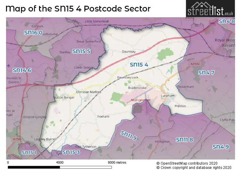
The largest settlement in the SN15 4 postal code is Lyneham followed by Sutton Benger, and Christian Malford.
The SN15 4 Postcode shares a border with SN11 9 (CALNE, Derry Hill, Studley), SN15 1 (CHIPPENHAM), SN4 7 (Royal Wootton Bassett, Broad Town, Bushton), SN11 8 (CALNE, Hilmarton, Cherhill), SN15 3 (CHIPPENHAM, Pewsham, Monkton Park) and SN15 5 (Brinkworth, Kington Langley, Great Somerford).
Map of the SN15 4 Postcode Sector
Explore the SN15 4 postcode sector by using our interactive map.
The sector is within the post town of CHIPPENHAM.
SN15 4 is a postcode sector within the SN15 postcode district which is within the SN Swindon postcode area.
The Royal Mail delivery office for the SN15 4 postal sector is the Chippenham Delivery Office.
The area of the SN15 4 postcode sector is 25.97 square miles which is 67.26 square kilometres or 16,620.35 square acres.
The SN15 4 postcode sector is crossed by the M4 motorway.
Waterways within the SN15 4 postcode sector include the River Avon, Wilts & Berks Canal, Dauntsey Lock, Seven Locks.
Your support helps keep this site running!
If you enjoy using this website, consider buying me a coffee to help cover hosting costs.


| S | N | 1 | 5 | - | 4 | X | X |
| S | N | 1 | 5 | Space | 4 | Letter | Letter |
Official List of Streets
Lyneham (50 Streets)
Sutton Benger (27 Streets)
(16 Streets)
Christian Malford (14 Streets)
Bradenstoke (9 Streets)
Dauntsey Lock (1 Streets)
Foxham (5 Streets)
Grittenham (1 Streets)
Langley Burrell (5 Streets)
Dauntsey (13 Streets)
East Tytherton (1 Streets)
Unofficial Streets or Alternative Spellings
Brinkworth
BROOKLANDS SCHOOL HILLRoyal Wootton Bassett
WHITEHILL LANEChristian Malford
ORCHARD LEAZESutton Benger
CHURCH PIECE GATE COURTGreat Somerford
DAUNTSEY ROADWeather Forecast for SN15 4
Weather Forecast for Lyneham
| Time Period | Icon | Description | Temperature | Rain Probability | Wind |
|---|---|---|---|---|---|
| 21:00 to 00:00 | Overcast | 5.0°C (feels like 1.0°C) | 9.00% | SSE 9 mph |
| Time Period | Icon | Description | Temperature | Rain Probability | Wind |
|---|---|---|---|---|---|
| 00:00 to 03:00 | Overcast | 4.0°C (feels like 1.0°C) | 9.00% | SSE 9 mph | |
| 03:00 to 06:00 | Cloudy | 4.0°C (feels like 1.0°C) | 9.00% | SSE 7 mph | |
| 06:00 to 09:00 | Partly cloudy (night) | 3.0°C (feels like 0.0°C) | 2.00% | SSE 7 mph | |
| 09:00 to 12:00 | Cloudy | 3.0°C (feels like 0.0°C) | 4.00% | SSE 4 mph | |
| 12:00 to 15:00 | Partly cloudy (day) | 6.0°C (feels like 2.0°C) | 1.00% | S 9 mph | |
| 15:00 to 18:00 | Partly cloudy (day) | 6.0°C (feels like 4.0°C) | 1.00% | S 7 mph | |
| 18:00 to 21:00 | Partly cloudy (night) | 4.0°C (feels like 2.0°C) | 2.00% | S 4 mph | |
| 21:00 to 00:00 | Clear night | 3.0°C (feels like 1.0°C) | 1.00% | S 4 mph |
| Time Period | Icon | Description | Temperature | Rain Probability | Wind |
|---|---|---|---|---|---|
| 00:00 to 03:00 | Overcast | 3.0°C (feels like 0.0°C) | 7.00% | S 4 mph | |
| 03:00 to 06:00 | Overcast | 4.0°C (feels like 1.0°C) | 9.00% | S 4 mph | |
| 06:00 to 09:00 | Overcast | 4.0°C (feels like 1.0°C) | 10.00% | S 4 mph | |
| 09:00 to 12:00 | Overcast | 4.0°C (feels like 1.0°C) | 9.00% | S 7 mph | |
| 12:00 to 15:00 | Cloudy | 7.0°C (feels like 4.0°C) | 6.00% | S 9 mph | |
| 15:00 to 18:00 | Cloudy | 8.0°C (feels like 5.0°C) | 5.00% | SSW 9 mph | |
| 18:00 to 21:00 | Cloudy | 6.0°C (feels like 3.0°C) | 5.00% | S 9 mph | |
| 21:00 to 00:00 | Cloudy | 6.0°C (feels like 3.0°C) | 6.00% | S 9 mph |
| Time Period | Icon | Description | Temperature | Rain Probability | Wind |
|---|---|---|---|---|---|
| 00:00 to 03:00 | Overcast | 6.0°C (feels like 3.0°C) | 11.00% | S 9 mph | |
| 03:00 to 06:00 | Cloudy | 6.0°C (feels like 2.0°C) | 6.00% | S 9 mph | |
| 06:00 to 09:00 | Cloudy | 6.0°C (feels like 2.0°C) | 7.00% | S 9 mph | |
| 09:00 to 12:00 | Cloudy | 7.0°C (feels like 4.0°C) | 8.00% | S 11 mph | |
| 12:00 to 15:00 | Cloudy | 9.0°C (feels like 6.0°C) | 16.00% | SSW 13 mph | |
| 15:00 to 18:00 | Light rain | 9.0°C (feels like 6.0°C) | 59.00% | SSW 11 mph | |
| 18:00 to 21:00 | Heavy rain | 8.0°C (feels like 5.0°C) | 72.00% | SW 9 mph | |
| 21:00 to 00:00 | Clear night | 7.0°C (feels like 4.0°C) | 9.00% | WSW 7 mph |
| Time Period | Icon | Description | Temperature | Rain Probability | Wind |
|---|---|---|---|---|---|
| 00:00 to 03:00 | Clear night | 6.0°C (feels like 3.0°C) | 5.00% | W 7 mph | |
| 03:00 to 06:00 | Clear night | 4.0°C (feels like 1.0°C) | 3.00% | W 4 mph | |
| 06:00 to 09:00 | Clear night | 2.0°C (feels like 0.0°C) | 2.00% | WNW 2 mph | |
| 09:00 to 12:00 | Cloudy | 3.0°C (feels like 2.0°C) | 4.00% | WNW 2 mph | |
| 12:00 to 15:00 | Cloudy | 7.0°C (feels like 5.0°C) | 4.00% | NNW 4 mph | |
| 15:00 to 18:00 | Cloudy | 7.0°C (feels like 6.0°C) | 5.00% | N 4 mph | |
| 18:00 to 21:00 | Cloudy | 4.0°C (feels like 2.0°C) | 5.00% | N 2 mph | |
| 21:00 to 00:00 | Partly cloudy (night) | 2.0°C (feels like 0.0°C) | 2.00% | E 2 mph |
Schools and Places of Education Within the SN15 4 Postcode Sector
Christian Malford CofE Primary School
Academy converter
Church Road, Chippenham, Wiltshire, SN15 4BW
Head: Ms Christina Brugger
Ofsted Rating: Requires improvement
Inspection: 2023-12-06 (423 days ago)
Website: Visit Christian Malford CofE Primary School Website
Phone: 01249720496
Number of Pupils: 67
Lyneham Primary School
Foundation school
Preston Lane, Chippenham, Wiltshire, SN15 4QJ
Head: Mr John Read
Ofsted Rating: Good
Inspection: 2021-11-24 (1165 days ago)
Website: Visit Lyneham Primary School Website
Phone: 01249890413
Number of Pupils: 301
Sutton Benger Church of England Primary School
Academy converter
40 Chestnut Road, Chippenham, Wiltshire, SN15 4RP
Head: Mrs Becca Hine
Ofsted Rating: Good
Inspection: 2023-11-02 (457 days ago)
Website: Visit Sutton Benger Church of England Primary School Website
Phone: 01249720407
Number of Pupils: 172
House Prices in the SN15 4 Postcode Sector
| Type of Property | 2018 Average | 2018 Sales | 2017 Average | 2017 Sales | 2016 Average | 2016 Sales | 2015 Average | 2015 Sales |
|---|---|---|---|---|---|---|---|---|
| Detached | £473,932 | 37 | £466,231 | 39 | £455,747 | 50 | £442,548 | 46 |
| Semi-Detached | £278,429 | 17 | £312,956 | 25 | £259,056 | 33 | £268,027 | 24 |
| Terraced | £220,421 | 14 | £219,075 | 20 | £184,960 | 29 | £189,174 | 34 |
| Flats | £0 | 0 | £115,000 | 1 | £131,409 | 11 | £100,000 | 1 |
Important Postcodes SN15 4 in the Postcode Sector
SN15 4BW is the postcode for Christian Malford C E Primary School, Church Road, Christian Malford
SN15 4HU is the postcode for Brinkworth Earl Danbys C of E Primary School, Lower School, Dauntsey Green
SN15 4PZ is the postcode for Royal Air Force, RAF Station Lyneham,
SN15 4QJ is the postcode for Lyneham Primary School, Preston Lane
SN15 4RP is the postcode for Sutton Benger CE Primary School, 40 Chestnut Road, Sutton Benger
| The SN15 4 Sector is within these Local Authorities |
|
|---|---|
| The SN15 4 Sector is within these Counties |
|
| The SN15 4 Sector is within these Water Company Areas |
|