A wide range of spatial data has been analysed to present this overview of the SN12 6 Postcode sector. If you would like anything added, please contact us.
The SN12 6 postcode sector is within the county of Wiltshire.
Did you know? According to the 2021 Census, the SN12 6 postcode sector is home to a bustling 10,283 residents!
Given that each sector allows for 400 unique postcode combinations. Letters C, I, K, M, O and V are not allowed in the last two letters of a postcode. With 336 postcodes already in use, this leaves 64 units available.
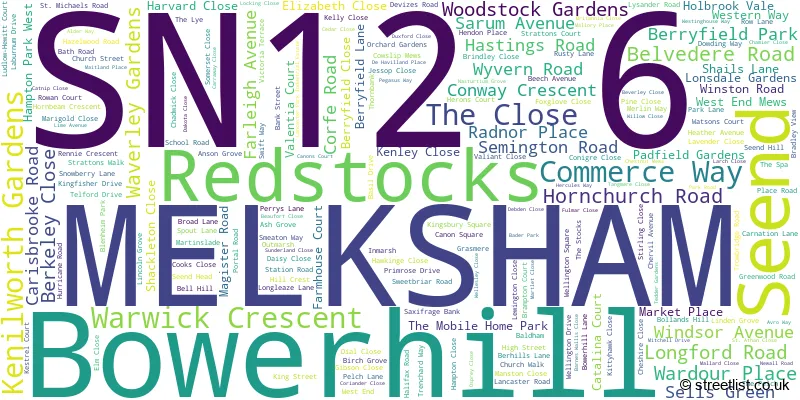
The largest settlement in the SN12 6 postal code is MELKSHAM followed by Bowerhill, and Seend.
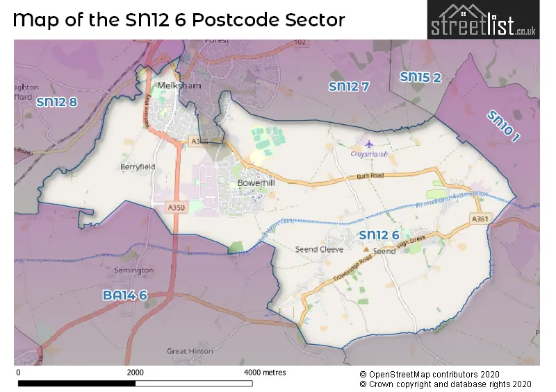
The SN12 6 Postcode shares a border with SN10 1 (DEVIZES, Poulshot, Bulkington), SN12 7 (MELKSHAM, Beanacre, Forest), SN12 8 (MELKSHAM, Atworth, Broughton Gifford) and BA14 6 (Holt, Steeple Ashton, Semington).
Map of the SN12 6 Postcode Sector
Explore the SN12 6 postcode sector by using our interactive map.
The sector is within the post town of MELKSHAM.
SN12 6 is a postcode sector within the SN12 postcode district which is within the SN Swindon postcode area.
The Royal Mail delivery office for the SN12 6 postal sector is the Melksham Delivery Office.
The area of the SN12 6 postcode sector is 7.79 square miles which is 20.18 square kilometres or 4,986.80 square acres.
Waterways within the SN12 6 postcode sector include the Kennet & Avon Canal, River Avon.
Your support helps keep this site running!
If you enjoy using this website, consider buying me a coffee to help cover hosting costs.

| S | N | 1 | 2 | - | 6 | X | X |
| S | N | 1 | 2 | Space | 6 | Letter | Letter |
Official List of Streets
MELKSHAM (109 Streets)
Bowerhill (74 Streets)
(24 Streets)
Seend (26 Streets)
Unofficial Streets or Alternative Spellings
Rowde
BERHILLS LANE BALDHAM BRIDGE BERGAMONT CLOSE CHALLYMEAD BRIDGE CICELY CLOSE CURNICKS LANE FARMERS ROUNDABOUT HAMPTON PARK INMARSH LANE LONG LEAZE LANE PACKHORSE BRIDGE PEEL COURT REDSTOCKS LANE SEMINGTON ROAD ROUNDABOUT SPA MEDICAL CENTRE SUMMERHAM BRIDGE WEAVERS COTTAGES WESTERN WAY ROUNDABOUTMELKSHAM
BRADFORD ROAD CORNFLOWER WAY CORONATION ROAD LOWBOURNE ROPE WALK SPA ROAD UNION STREETSemington
HIGH STREETWeather Forecast for SN12 6
Weather Forecast for Melksham
| Time Period | Icon | Description | Temperature | Rain Probability | Wind |
|---|---|---|---|---|---|
| 09:00 to 12:00 | Cloudy | 5.0°C (feels like 3.0°C) | 8.00% | SE 4 mph | |
| 12:00 to 15:00 | Cloudy | 7.0°C (feels like 5.0°C) | 8.00% | SSE 9 mph | |
| 15:00 to 18:00 | Cloudy | 7.0°C (feels like 5.0°C) | 9.00% | SSE 9 mph | |
| 18:00 to 21:00 | Cloudy | 6.0°C (feels like 3.0°C) | 8.00% | SSE 9 mph | |
| 21:00 to 00:00 | Cloudy | 5.0°C (feels like 2.0°C) | 4.00% | SSE 9 mph |
| Time Period | Icon | Description | Temperature | Rain Probability | Wind |
|---|---|---|---|---|---|
| 00:00 to 03:00 | Cloudy | 5.0°C (feels like 1.0°C) | 4.00% | SSE 9 mph | |
| 03:00 to 06:00 | Partly cloudy (night) | 4.0°C (feels like 0.0°C) | 1.00% | SSE 9 mph | |
| 06:00 to 09:00 | Partly cloudy (night) | 3.0°C (feels like 0.0°C) | 4.00% | SSE 9 mph | |
| 09:00 to 12:00 | Partly cloudy (day) | 4.0°C (feels like 1.0°C) | 5.00% | SSE 9 mph | |
| 12:00 to 15:00 | Partly cloudy (day) | 7.0°C (feels like 4.0°C) | 5.00% | S 9 mph | |
| 15:00 to 18:00 | Sunny day | 8.0°C (feels like 5.0°C) | 3.00% | S 7 mph | |
| 18:00 to 21:00 | Partly cloudy (night) | 4.0°C (feels like 2.0°C) | 3.00% | S 4 mph | |
| 21:00 to 00:00 | Clear night | 3.0°C (feels like 1.0°C) | 3.00% | S 7 mph |
| Time Period | Icon | Description | Temperature | Rain Probability | Wind |
|---|---|---|---|---|---|
| 00:00 to 03:00 | Clear night | 3.0°C (feels like 0.0°C) | 2.00% | S 7 mph | |
| 03:00 to 06:00 | Clear night | 3.0°C (feels like 0.0°C) | 3.00% | S 7 mph | |
| 06:00 to 09:00 | Partly cloudy (night) | 4.0°C (feels like 1.0°C) | 4.00% | S 7 mph | |
| 09:00 to 12:00 | Cloudy | 5.0°C (feels like 2.0°C) | 7.00% | S 9 mph | |
| 12:00 to 15:00 | Cloudy | 9.0°C (feels like 6.0°C) | 5.00% | SSW 11 mph | |
| 15:00 to 18:00 | Cloudy | 9.0°C (feels like 7.0°C) | 5.00% | SSW 11 mph | |
| 18:00 to 21:00 | Cloudy | 7.0°C (feels like 4.0°C) | 6.00% | S 11 mph | |
| 21:00 to 00:00 | Cloudy | 7.0°C (feels like 4.0°C) | 7.00% | S 11 mph |
| Time Period | Icon | Description | Temperature | Rain Probability | Wind |
|---|---|---|---|---|---|
| 00:00 to 03:00 | Cloudy | 7.0°C (feels like 4.0°C) | 11.00% | S 11 mph | |
| 03:00 to 06:00 | Cloudy | 7.0°C (feels like 4.0°C) | 12.00% | S 13 mph | |
| 06:00 to 09:00 | Cloudy | 8.0°C (feels like 4.0°C) | 14.00% | SSW 13 mph | |
| 09:00 to 12:00 | Cloudy | 8.0°C (feels like 5.0°C) | 19.00% | SSW 13 mph | |
| 12:00 to 15:00 | Light rain | 10.0°C (feels like 7.0°C) | 54.00% | SSW 16 mph | |
| 15:00 to 18:00 | Heavy rain | 10.0°C (feels like 8.0°C) | 72.00% | SW 13 mph | |
| 18:00 to 21:00 | Heavy rain | 9.0°C (feels like 6.0°C) | 68.00% | WSW 9 mph | |
| 21:00 to 00:00 | Cloudy | 7.0°C (feels like 5.0°C) | 15.00% | WSW 9 mph |
Schools and Places of Education Within the SN12 6 Postcode Sector
Aloeric Primary School
Academy converter
St Michael's Road, Melksham, Wiltshire, SN12 6HN
Head: Mrs Rebecca Clifton
Ofsted Rating: Good
Inspection: 2022-04-27 (1011 days ago)
Website: Visit Aloeric Primary School Website
Phone: 01225702563
Number of Pupils: 387
Bowerhill Primary School
Academy converter
Halifax Road, Melksham, Wiltshire, SN12 6YH
Head: Mr Christopher Light
Ofsted Rating: Requires improvement
Inspection: 2022-02-02 (1095 days ago)
Website: Visit Bowerhill Primary School Website
Phone: 01225700964
Number of Pupils: 406
Melksham Oak Community School
Academy converter
, Melksham, Wiltshire, SN12 6QZ
Head: Mr Haris Hussain
Ofsted Rating: Good
Inspection: 2022-10-05 (850 days ago)
Website: Visit Melksham Oak Community School Website
Phone: 01225792700
Number of Pupils: 1282
Seend Church of England Primary School
Academy converter
School Road, Melksham, Wiltshire, SN12 6NJ
Head: Ms Emma Hembury
Ofsted Rating: Good
Inspection: 2022-12-13 (781 days ago)
Website: Visit Seend Church of England Primary School Website
Phone: 01380828334
Number of Pupils: 102
House Prices in the SN12 6 Postcode Sector
| Type of Property | 2018 Average | 2018 Sales | 2017 Average | 2017 Sales | 2016 Average | 2016 Sales | 2015 Average | 2015 Sales |
|---|---|---|---|---|---|---|---|---|
| Detached | £339,007 | 62 | £327,337 | 44 | £322,115 | 54 | £291,930 | 50 |
| Semi-Detached | £253,041 | 41 | £251,638 | 43 | £245,205 | 50 | £214,061 | 52 |
| Terraced | £195,330 | 40 | £200,578 | 44 | £184,802 | 62 | £191,865 | 42 |
| Flats | £114,958 | 13 | £136,806 | 8 | £115,785 | 10 | £105,652 | 22 |
Important Postcodes SN12 6 in the Postcode Sector
SN12 6DD is the postcode for Wiltshire Fire Brigade, Fire Station, Semington Road
SN12 6ES is the postcode for Melksham Blue Pool, Market Place, Assembly Hall, Market Place, The Blue Pool, Market Place, and Town Hall, Market Place
SN12 6HN is the postcode for MAIN BUILDING, Aloeric GM Primary School, St. Michaels Road, Main Building, Aloeric Primary School, St Michaels Road, and Key Stage 2 Building, Aloeric Primary School, St. Michael's Road
SN12 6NJ is the postcode for Seend Primary School, School Road
SN12 6QQ is the postcode for Wiltshire Constabulary, Hampton Park West
SN12 6QT is the postcode for Wiltshire Council, Safety Unit and Gritter Garage, and Wiltshire Council, Melksham Highways Depot
SN12 6QU is the postcode for Christie Miller Sports Centre, Lancaster Road
SN12 6QZ is the postcode for Melksham Oak Community School, Bowerhill, SPORTS BUILDING, Melksham Oak Community School, Devizes Road, Melksham Oak Community School, Devizes Road, and SPORTS HALL, Melksham Oak Community School, Bowerhill
SN12 6UN is the postcode for Spa Medical Centre, Snowberry Lane
SN12 6YH is the postcode for BOWERHILL PRIMARY SCHOOL, HALIFAX ROAD, Halifax Road, BOWERHILL PRIMARY SCHOOL, HALIFAX ROAD, and Bowerhill Cp School, Halifax Road
SN12 6ZZ is the postcode for Royal Mail, Melksham Delivery Office, 31a Church Street
| The SN12 6 Sector is within these Local Authorities |
|
|---|---|
| The SN12 6 Sector is within these Counties |
|
| The SN12 6 Sector is within these Water Company Areas |
|