A wide range of spatial data has been analysed to present this overview of the SN11 0 Postcode sector. If you would like anything added, please contact us.
The SN11 0 postcode sector is within the county of Wiltshire.
Did you know? According to the 2021 Census, the SN11 0 postcode sector is home to a bustling 6,477 residents!
Given that each sector allows for 400 unique postcode combinations. Letters C, I, K, M, O and V are not allowed in the last two letters of a postcode. With 234 postcodes already in use, this leaves 166 units available.
The largest settlement in the SN11 0 postal code is CALNE followed by Heddington, and Stockley.
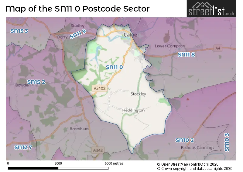
The SN11 0 Postcode shares a border with SN11 9 (CALNE, Derry Hill, Studley), SN10 2 (DEVIZES, Rowde, Bishop's Cannings), SN11 8 (CALNE, Hilmarton, Cherhill) and SN15 2 (CHIPPENHAM, Bromham, Lacock).
Map of the SN11 0 Postcode Sector
Explore the SN11 0 postcode sector by using our interactive map.
The sector is within the post town of CALNE.
SN11 0 is a postcode sector within the SN11 postcode district which is within the SN Swindon postcode area.
The Royal Mail delivery office for the SN11 0 postal sector is the Calne Delivery Office.
The area of the SN11 0 postcode sector is 9.39 square miles which is 24.33 square kilometres or 6,010.94 square acres.
Waterways within the SN11 0 postcode sector include the Wilts & Berks Canal, Conigre Tunnel, River Marden, Chaveywell Wharf.
Your support helps keep this site running!
If you enjoy using this website, consider buying me a coffee to help cover hosting costs.


| S | N | 1 | 1 | - | 0 | X | X |
| S | N | 1 | 1 | Space | 0 | Letter | Letter |
Official List of Streets
CALNE (117 Streets)
Heddington (13 Streets)
Stockley (4 Streets)
Unofficial Streets or Alternative Spellings
CALNE
BEACH TERRACE BRYANS CLOSE ROAD CARPENTERS CLOSE DIXON WAY KINGSBURY STREET LICKHILL ROAD OXFORD ROAD SHELBURNE ROAD THE GREEN THE PIPPIN THE WHARFWeather Forecast for SN11 0
Weather Forecast for Bowood House & Gardens
| Time Period | Icon | Description | Temperature | Rain Probability | Wind |
|---|---|---|---|---|---|
| 06:00 to 09:00 | Cloudy | 3.0°C (feels like 0.0°C) | 8.00% | SSE 7 mph | |
| 09:00 to 12:00 | Cloudy | 3.0°C (feels like 0.0°C) | 4.00% | SSE 7 mph | |
| 12:00 to 15:00 | Partly cloudy (day) | 6.0°C (feels like 3.0°C) | 1.00% | S 9 mph | |
| 15:00 to 18:00 | Partly cloudy (day) | 7.0°C (feels like 4.0°C) | 1.00% | S 9 mph | |
| 18:00 to 21:00 | Partly cloudy (night) | 4.0°C (feels like 1.0°C) | 2.00% | S 4 mph | |
| 21:00 to 00:00 | Partly cloudy (night) | 3.0°C (feels like 0.0°C) | 1.00% | S 7 mph |
| Time Period | Icon | Description | Temperature | Rain Probability | Wind |
|---|---|---|---|---|---|
| 00:00 to 03:00 | Overcast | 3.0°C (feels like 0.0°C) | 7.00% | S 7 mph | |
| 03:00 to 06:00 | Overcast | 4.0°C (feels like 1.0°C) | 9.00% | S 7 mph | |
| 06:00 to 09:00 | Overcast | 4.0°C (feels like 1.0°C) | 9.00% | S 7 mph | |
| 09:00 to 12:00 | Overcast | 5.0°C (feels like 2.0°C) | 9.00% | S 9 mph | |
| 12:00 to 15:00 | Cloudy | 8.0°C (feels like 5.0°C) | 6.00% | S 11 mph | |
| 15:00 to 18:00 | Cloudy | 9.0°C (feels like 6.0°C) | 5.00% | SSW 11 mph | |
| 18:00 to 21:00 | Cloudy | 7.0°C (feels like 4.0°C) | 5.00% | S 11 mph | |
| 21:00 to 00:00 | Cloudy | 6.0°C (feels like 3.0°C) | 6.00% | S 11 mph |
| Time Period | Icon | Description | Temperature | Rain Probability | Wind |
|---|---|---|---|---|---|
| 00:00 to 03:00 | Overcast | 7.0°C (feels like 3.0°C) | 11.00% | S 11 mph | |
| 03:00 to 06:00 | Cloudy | 6.0°C (feels like 3.0°C) | 6.00% | S 11 mph | |
| 06:00 to 09:00 | Cloudy | 6.0°C (feels like 3.0°C) | 7.00% | S 11 mph | |
| 09:00 to 12:00 | Cloudy | 8.0°C (feels like 4.0°C) | 8.00% | S 13 mph | |
| 12:00 to 15:00 | Cloudy | 10.0°C (feels like 7.0°C) | 16.00% | SSW 18 mph | |
| 15:00 to 18:00 | Light rain | 10.0°C (feels like 7.0°C) | 58.00% | SSW 13 mph | |
| 18:00 to 21:00 | Heavy rain | 9.0°C (feels like 6.0°C) | 72.00% | SW 11 mph | |
| 21:00 to 00:00 | Clear night | 7.0°C (feels like 4.0°C) | 10.00% | WSW 9 mph |
| Time Period | Icon | Description | Temperature | Rain Probability | Wind |
|---|---|---|---|---|---|
| 00:00 to 03:00 | Clear night | 6.0°C (feels like 3.0°C) | 5.00% | W 7 mph | |
| 03:00 to 06:00 | Clear night | 4.0°C (feels like 1.0°C) | 3.00% | W 7 mph | |
| 06:00 to 09:00 | Clear night | 2.0°C (feels like 0.0°C) | 2.00% | WNW 4 mph | |
| 09:00 to 12:00 | Cloudy | 3.0°C (feels like 2.0°C) | 4.00% | WNW 4 mph | |
| 12:00 to 15:00 | Cloudy | 7.0°C (feels like 6.0°C) | 4.00% | NNW 4 mph | |
| 15:00 to 18:00 | Cloudy | 8.0°C (feels like 6.0°C) | 5.00% | N 4 mph | |
| 18:00 to 21:00 | Cloudy | 4.0°C (feels like 2.0°C) | 5.00% | N 4 mph | |
| 21:00 to 00:00 | Partly cloudy (night) | 2.0°C (feels like 0.0°C) | 2.00% | E 4 mph |
Schools and Places of Education Within the SN11 0 Postcode Sector
Heddington Church of England Primary School
Voluntary aided school
Church Road, Calne, Wiltshire, SN11 0PJ
Head: Mr Ashley Martin
Ofsted Rating: Good
Inspection: 2023-07-06 (577 days ago)
Website: Visit Heddington Church of England Primary School Website
Phone: 01380850489
Number of Pupils: 75
Holy Trinity Church of England Academy
Academy converter
Quemerford, Calne, Wiltshire, SN11 0AR
Head: Mr Graham Shore
Ofsted Rating: Good
Inspection: 2021-11-04 (1186 days ago)
Website: Visit Holy Trinity Church of England Academy Website
Phone: 01249812424
Number of Pupils: 209
The Springfields Academy
Academy special sponsor led
Curzon Street, Calne, Wiltshire, SN11 0DS
Head: Mrs Nicola Whitcombe
Ofsted Rating: Good
Inspection: 2022-03-10 (1060 days ago)
Website: Visit The Springfields Academy Website
Phone: 01249814125
Number of Pupils: 231
House Prices in the SN11 0 Postcode Sector
| Type of Property | 2018 Average | 2018 Sales | 2017 Average | 2017 Sales | 2016 Average | 2016 Sales | 2015 Average | 2015 Sales |
|---|---|---|---|---|---|---|---|---|
| Detached | £366,284 | 75 | £384,277 | 75 | £344,821 | 73 | £293,618 | 47 |
| Semi-Detached | £274,028 | 34 | £245,303 | 31 | £222,260 | 35 | £214,552 | 30 |
| Terraced | £187,857 | 44 | £202,444 | 45 | £180,302 | 62 | £168,552 | 74 |
| Flats | £131,375 | 16 | £122,000 | 8 | £144,500 | 6 | £106,438 | 8 |
Important Postcodes SN11 0 in the Postcode Sector
SN11 0AR is the postcode for Holy Trinity School, 1 Quemerford
SN11 0BP is the postcode for Royal Mail, Calne Delivery Office, 22-24 High Street
SN11 0DS is the postcode for Springfields School, Curzon Street, Springfield School, Curzon Street, and NEW BUILDING, Springfields School, Curzon Street
SN11 0EF is the postcode for Patford House Surgery, 8 Patford Street
SN11 0EN is the postcode for Calne Town Hall, The Strand
SN11 0HH is the postcode for Northlands Surgery, North Street
SN11 0JJ is the postcode for Wiltshire Council - Calne Library
SN11 0JW is the postcode for Wiltshire Fire Brigade, Fire Station, Station Road
SN11 0SP is the postcode for Calne Leisure, White Horse Way, CALNE LEISURE CENTRE, WHITE HORSE WAY, CALNE, and Calne Community Campus, White Horse Way
| The SN11 0 Sector is within these Local Authorities |
|
|---|---|
| The SN11 0 Sector is within these Counties |
|
| The SN11 0 Sector is within these Water Company Areas |
|
Tourist Attractions within the SN11 0 Postcode Area
We found 1 visitor attractions within the SN11 postcode area
| Calne Heritage Centre |
|---|
| Visitor Centres |
| Heritage / Visitor Centre |
| View Calne Heritage Centre on Google Maps |