A wide range of spatial data has been analysed to present this overview of the SM5 3 Postcode sector. If you would like anything added, please contact us.
The SM5 3 postcode sector is within the county of Greater London.
Did you know? According to the 2021 Census, the SM5 3 postcode sector is home to a bustling 8,501 residents!
Given that each sector allows for 400 unique postcode combinations. Letters C, I, K, M, O and V are not allowed in the last two letters of a postcode. With 161 postcodes already in use, this leaves 239 units available.
The SM5 3 postal code covers the settlement of CARSHALTON .
The SM5 3 Postcode shares a border with SM1 4 (SUTTON ), SM5 4 (CARSHALTON , LITTLE WOODCOTE ESTATE ), SM6 0 (WALLINGTON ), SM6 7 (WALLINGTON , HACKBRIDGE , BEDDINGTON ), SM2 5 (SUTTON ) and SM5 2 (CARSHALTON ).
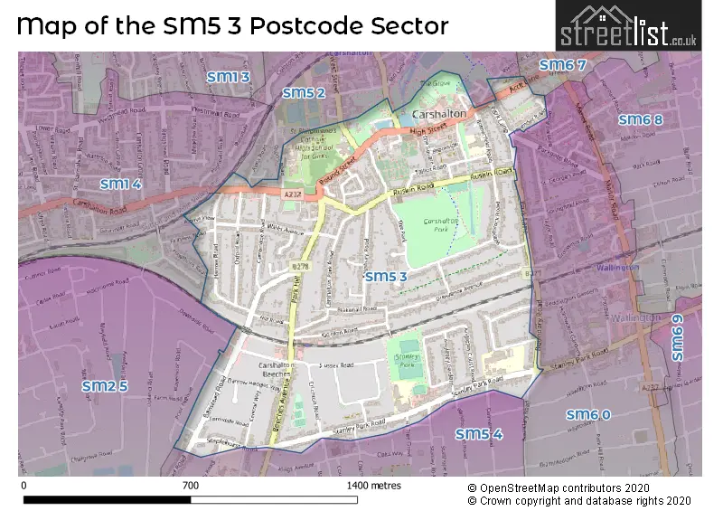
Map of the SM5 3 Postcode Sector
Explore the SM5 3 postcode sector by using our interactive map.
The sector is within the post town of CARSHALTON.
SM5 3 is a postcode sector within the SM5 postcode district which is within the SM Sutton postcode area.
The Royal Mail delivery office for the SM5 3 postal sector is the Wallington Delivery Office.
The area of the SM5 3 postcode sector is 0.68 square miles which is 1.75 square kilometres or 433.48 square acres.
Waterways within the SM5 3 postcode sector include the River Wandle.
Your support helps keep this site running!
If you enjoy using this website, consider buying me a coffee to help cover hosting costs.

| S | M | 5 | - | 3 | X | X |
| S | M | 5 | Space | 3 | Letter | Letter |
Official List of Streets
CARSHALTON (75 Streets)
(4 Streets)
Unofficial Streets or Alternative Spellings
WALLINGTON
GROSVENOR ROAD PARKGATE ROAD PARK VIEW CLOSE QUEEN MARYS AVENUECARSHALTON
ALMA ROAD BALFOUR ROAD DALMENY ROAD FIR TREE GROVE HARBURY ROAD NORTH STREET RADCLIFFE GARDENS STANLEY ROAD THE AVENUE WEST STREET WINDBOROUGH ROAD WOODMANSTERNE ROADCARSHALTON,
ACRE LANE BEDDINGTON GARDENS BOUNDARY ROAD CARSHALTON ROAD PARK LANE STANLEY PARK ROAD WESTCROFT ROADSUTTON
DOWNSIDE ROAD FAIRVIEW ROAD HAWTHORN ROAD PRIOR AVENUE WILLIS AVENUEWeather Forecast for SM5 3
Weather Forecast for Sutton
| Time Period | Icon | Description | Temperature | Rain Probability | Wind |
|---|---|---|---|---|---|
| 00:00 to 03:00 | Partly cloudy (night) | 3.0°C (feels like 1.0°C) | 0.00% | SE 4 mph | |
| 03:00 to 06:00 | Clear night | 3.0°C (feels like 0.0°C) | 0.00% | SSE 4 mph | |
| 06:00 to 09:00 | Clear night | 2.0°C (feels like -1.0°C) | 0.00% | SE 4 mph | |
| 09:00 to 12:00 | Sunny day | 2.0°C (feels like 0.0°C) | 0.00% | SE 4 mph | |
| 12:00 to 15:00 | Sunny day | 6.0°C (feels like 3.0°C) | 0.00% | SSE 7 mph | |
| 15:00 to 18:00 | Sunny day | 7.0°C (feels like 5.0°C) | 0.00% | SSE 7 mph | |
| 18:00 to 21:00 | Clear night | 4.0°C (feels like 2.0°C) | 0.00% | S 4 mph | |
| 21:00 to 00:00 | Clear night | 2.0°C (feels like 1.0°C) | 1.00% | S 4 mph |
| Time Period | Icon | Description | Temperature | Rain Probability | Wind |
|---|---|---|---|---|---|
| 00:00 to 03:00 | Clear night | 2.0°C (feels like -1.0°C) | 1.00% | S 4 mph | |
| 03:00 to 06:00 | Clear night | 1.0°C (feels like -1.0°C) | 2.00% | SSW 4 mph | |
| 06:00 to 09:00 | Cloudy | 1.0°C (feels like -1.0°C) | 6.00% | S 4 mph | |
| 09:00 to 12:00 | Cloudy | 3.0°C (feels like 0.0°C) | 6.00% | S 4 mph | |
| 12:00 to 15:00 | Partly cloudy (day) | 6.0°C (feels like 4.0°C) | 2.00% | SSW 7 mph | |
| 15:00 to 18:00 | Sunny day | 7.0°C (feels like 5.0°C) | 2.00% | SSW 7 mph | |
| 18:00 to 21:00 | Partly cloudy (night) | 4.0°C (feels like 2.0°C) | 2.00% | S 7 mph | |
| 21:00 to 00:00 | Partly cloudy (night) | 4.0°C (feels like 1.0°C) | 3.00% | S 7 mph |
| Time Period | Icon | Description | Temperature | Rain Probability | Wind |
|---|---|---|---|---|---|
| 00:00 to 03:00 | Partly cloudy (night) | 4.0°C (feels like 1.0°C) | 3.00% | S 9 mph | |
| 03:00 to 06:00 | Partly cloudy (night) | 4.0°C (feels like 1.0°C) | 3.00% | S 9 mph | |
| 06:00 to 09:00 | Clear night | 4.0°C (feels like 1.0°C) | 3.00% | SSW 9 mph | |
| 09:00 to 12:00 | Sunny day | 6.0°C (feels like 2.0°C) | 2.00% | S 11 mph | |
| 12:00 to 15:00 | Cloudy | 9.0°C (feels like 5.0°C) | 5.00% | SSW 13 mph | |
| 15:00 to 18:00 | Cloudy | 9.0°C (feels like 6.0°C) | 9.00% | SSW 13 mph | |
| 18:00 to 21:00 | Overcast | 8.0°C (feels like 5.0°C) | 21.00% | SSW 11 mph | |
| 21:00 to 00:00 | Light rain | 8.0°C (feels like 5.0°C) | 47.00% | SW 9 mph |
| Time Period | Icon | Description | Temperature | Rain Probability | Wind |
|---|---|---|---|---|---|
| 00:00 to 03:00 | Clear night | 6.0°C (feels like 4.0°C) | 8.00% | W 7 mph | |
| 03:00 to 06:00 | Clear night | 5.0°C (feels like 3.0°C) | 4.00% | WNW 7 mph | |
| 06:00 to 09:00 | Clear night | 3.0°C (feels like 1.0°C) | 2.00% | WNW 4 mph | |
| 09:00 to 12:00 | Partly cloudy (day) | 4.0°C (feels like 2.0°C) | 1.00% | NW 4 mph | |
| 12:00 to 15:00 | Partly cloudy (day) | 7.0°C (feels like 5.0°C) | 2.00% | NNW 4 mph | |
| 15:00 to 18:00 | Cloudy | 8.0°C (feels like 7.0°C) | 5.00% | N 4 mph | |
| 18:00 to 21:00 | Cloudy | 5.0°C (feels like 4.0°C) | 5.00% | N 4 mph | |
| 21:00 to 00:00 | Cloudy | 4.0°C (feels like 2.0°C) | 5.00% | NNE 4 mph |
Schools and Places of Education Within the SM5 3 Postcode Sector
All Saints Carshalton Church of England Primary School
Academy converter
Rotherfield Road, Carshalton, Surrey, SM5 3DW
Head: Mrs Laurielle Jackson
Ofsted Rating: Good
Inspection: 2019-10-30 (1922 days ago)
Website: Visit All Saints Carshalton Church of England Primary School Website
Phone: 02084010075
Number of Pupils: 447
St Philomena's Catholic High School for Girls
Voluntary aided school
Shorts Road, Carshalton, Surrey, SM5 3PS
Head: Ms Maria Noone
Ofsted Rating: Good
Inspection: 2022-02-25 (1073 days ago)
Website: Visit St Philomena's Catholic High School for Girls Website
Phone: 02086422025
Number of Pupils: 1479
Stanley Park Infants School
Academy converter
Stanley Park Road, Carshalton, Surrey, SM5 3JL
Head: Mr David D'Souza
Ofsted Rating: Good
Inspection: 2022-12-14 (781 days ago)
Website: Visit Stanley Park Infants School Website
Phone: 02086479322
Number of Pupils: 291
Stanley Park Junior School
Foundation school
Stanley Park Road, Carshalton, Surrey, SM5 3JL
Head: Mrs Amanda Lamy
Ofsted Rating: Good
Inspection: 2023-09-14 (507 days ago)
Website: Visit Stanley Park Junior School Website
Phone: 02086477497
Number of Pupils: 373
House Prices in the SM5 3 Postcode Sector
| Type of Property | 2018 Average | 2018 Sales | 2017 Average | 2017 Sales | 2016 Average | 2016 Sales | 2015 Average | 2015 Sales |
|---|---|---|---|---|---|---|---|---|
| Detached | £685,412 | 17 | £646,002 | 23 | £702,333 | 12 | £536,438 | 16 |
| Semi-Detached | £582,321 | 29 | £573,184 | 35 | £557,930 | 51 | £514,554 | 59 |
| Terraced | £429,654 | 24 | £431,140 | 25 | £457,963 | 27 | £417,854 | 24 |
| Flats | £277,925 | 20 | £273,500 | 23 | £283,339 | 28 | £236,125 | 28 |
Important Postcodes SM5 3 in the Postcode Sector
SM5 3AL is the postcode for London Borough of Sutton, The Grove, High Street, and EXCLUDING THE NEST AND WORKSHOP, London Borough of Sutton, The Grove, High Street
SM5 3BB is the postcode for MAIN BUILDING ONLY, The Charles Cryer Studio Theatre, 39 High Street, and The Charles Cryer Studio Theatre, 39 High Street
SM5 3DW is the postcode for School House, Rotherfield Road, and All Saints Carshalton CE Primary School, Rotherfield Road
SM5 3HP is the postcode for Stanley Park High School, Stanley Park Road
SM5 3HW is the postcode for Sherwood Hill Campus School, Stanley Park Road, Woodfield Primary School, Stanley Park Road, WOOD FIELD, Bandon Hill Primary School, Wood Field, Stanley Park Road, and OAK FIELD, Bandon Hill Primary School, Wood Field, Stanley Park Road
SM5 3JL is the postcode for Stanley Park Junior School, Stanley Park Road, and Stanley Park Infant School, Stanley Park Road
SM5 3NX is the postcode for Childrens Services, The Lodge, and The Lodge, Honeywood Walk
SM5 3PS is the postcode for GYM, St. Philomenas School, Pound Street, WHITE HOUSE, St. Philomenas School, Pound Street, VERITAS BUILDING, St. Philomenas School, Pound Street, St. Philomenas School, Pound Street, and SCIENCE BUNGALOW, St. Philomenas School, Pound Street
| The SM5 3 Sector is within these Local Authorities |
|
|---|---|
| The SM5 3 Sector is within these Counties |
|
| The SM5 3 Sector is within these Water Company Areas |
|