The SL5 8 postcode sector stands on the Berkshire and Surrey border.
Did you know? According to the 2021 Census, the SL5 8 postcode sector is home to a bustling 7,581 residents!
Given that each sector allows for 400 unique postcode combinations. Letters C, I, K, M, O and V are not allowed in the last two letters of a postcode. With 217 postcodes already in use, this leaves 183 units available.
The largest settlements in the SL5 8 postal code are ASCOT and Chavey Down.
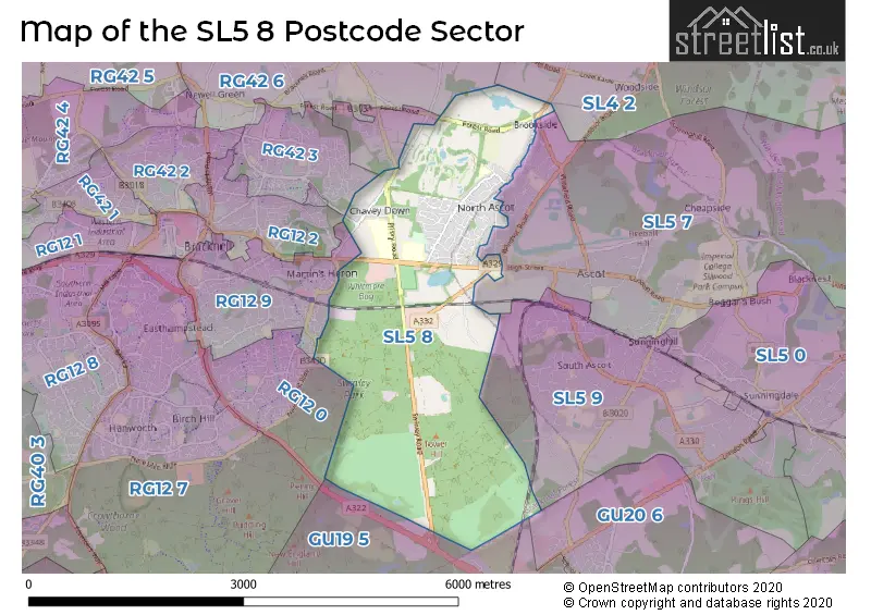
The SL5 8 Postcode shares a border with RG12 0 (BRACKNELL), RG12 2 (BRACKNELL), RG42 7 (Winkfield Row, Warfield, BRACKNELL), RG42 3 (Warfield, Warfield Park, BRACKNELL), SL5 7 (ASCOT, Sunninghill), SL5 9 (ASCOT, Sunningdale, Sunninghill), GU20 6 (WINDLESHAM), RG12 9 (BRACKNELL), RG42 6 (Warfield, Winkfield Row), SL4 2 (Old Windsor, WINDSOR, Winkfield) and GU19 5 (BAGSHOT).
The sector is within the post town of ASCOT.
SL5 8 is a postcode sector within the SL5 postcode district which is within the SL Slough postcode area.
The Royal Mail delivery office for the SL5 8 postal sector is the Ascot Delivery Office.
The area of the SL5 8 postcode sector is 4.94 square miles which is 12.79 square kilometres or 3,161.00 square acres.


Map of the SL5 8 Postcode Sector
Explore the SL5 8 postcode sector by using our free interactive map.
| S | L | 5 | - | 8 | X | X |
| S | L | 5 | Space | 8 | Letter | Letter |
Official List of Streets
ASCOT (91 Streets)
Chavey Down (2 Streets)
North Ascot (1 Streets)
Unofficial Streets or Alternative Spellings
ASCOT
FURLONG DRIVE GEFFERS RIDE HIGH STREET HIGHGROVE AVENUE KENNEL CLOSE KENNEL RIDE WINKFIELD ROAD ALDERSON CLOSE BLANES LANE BOG LANE CANNON MEWS COACH ROAD ELLIOT RISE ENGLEMERE PARK FERN GARDENS HARVEST RIDE HEATHERWOOD HOSPITAL HODGE LANE HOLLYBUSH TRACK HORSEGATE RIDE LIME AVENUE LONG HILL ROUNDABOUT LONG HILL ROUNDABOUT CYCLE PATH SCOTTS MEWS WARFIELD PARK WINDSOR RIDE WINDSOR ROAD CYCLE PATH (SOUTH) WOODEND CLOSE WOODMILL COURTBRACKNELL
NEW FOREST RIDEASCOT,
LONDON ROAD LONG HILL ROADWinkfield
HATCHET LANE WINDSOR ROADWinkfield Row
CHAVEY DOWN ROADWarfield
FOREST ROADSchools and Places of Education Within the SL5 8 Postcode Sector
Ascot Heath Primary School
Community school
Rhododendron Walk, Ascot, Berkshire, SL5 8PN
Head: Mrs Rachel Bradley
Ofsted Rating: Good
Inspection: 2023-12-06 (205 days ago)
Website: Visit Ascot Heath Primary School Website
Phone: 01344882631
Number of Pupils: 395
House Prices in the SL5 8 Postcode Sector
| Type of Property | 2018 Average | 2018 Sales | 2017 Average | 2017 Sales | 2016 Average | 2016 Sales | 2015 Average | 2015 Sales |
|---|---|---|---|---|---|---|---|---|
| Detached | £832,411 | 40 | £707,515 | 33 | £651,520 | 25 | £840,491 | 45 |
| Semi-Detached | £506,359 | 48 | £476,341 | 46 | £433,499 | 55 | £434,092 | 43 |
| Terraced | £450,275 | 18 | £440,073 | 13 | £434,313 | 8 | £380,647 | 17 |
| Flats | £317,923 | 13 | £617,978 | 37 | £498,863 | 40 | £267,249 | 42 |
Important Postcodes SL5 8 in the Postcode Sector
SL5 8AA is the postcode for Heatherwood Hospital, London Road, MATERNITY BLOCK, Heatherwood Hospital, London Road, Forest and Ascot Building, Heatherwood Hospital, MI / EMI BLOCK, Heatherwood Hospital, London Road, PAUL BEVAN HOUSE, Heatherwood Hospital, London Road, Heatherwood and Wexham Park Hospitals NHS Foundation Trust, Heatherwood Hospital, WARDS 1, 2 & 3, Heatherwood Hospital, London Road, WARDS 4 & 5, Heatherwood Hospital, London Road, and OPERATING THEATRES, Heatherwood Hospital, London Road
SL5 8PN is the postcode for Ascot Heath Infant School, Rhododendron Walk, and Ascot Heath Junior School, Rhododendron Walk
| The SL5 8 Sector is within these Local Authorities |
|
|---|---|
| The SL5 8 Sector is within these Counties |
|
| The SL5 8 Sector is within these Water Company Areas |
|