A wide range of spatial data has been analysed to present this overview of the SL3 9 Postcode sector. If you would like anything added, please contact us.
The SL3 9 Datchet Postcode Sector
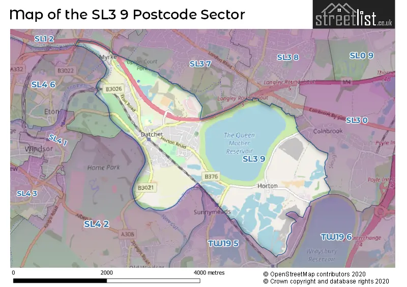
The SL3 9 postcode sector stands on the Berkshire and Surrey border.
Did you know? According to the 2021 Census, the SL3 9 postcode sector is home to a bustling 5,958 residents!
Given that each sector allows for 400 unique postcode combinations. Letters C, I, K, M, O and V are not allowed in the last two letters of a postcode. With 172 postcodes already in use, this leaves 228 units available.
The largest settlements in the SL3 9 postal code are Datchet and HORTON.
The SL3 9 Postcode shares a border with SL1 2 (SLOUGH, Chalvey), SL3 0 (POYLE, COLNBROOK), SL3 7 (SLOUGH), SL3 8 (SLOUGH, LANGLEY), SL4 2 (Old Windsor, WINDSOR, Winkfield), SL4 6 (Eton Wick, Eton, Dorney), TW19 5 (WRAYSBURY) and TW19 6 (STANWELL MOOR, STAINES-UPON-THAMES, WRAYSBURY).
Map of the SL3 9 Postcode Sector
Explore the SL3 9 postcode sector by using our interactive map.
The sector is within the post town of SLOUGH.
SL3 9 is a postcode sector within the SL3 postcode district which is within the SL Slough postcode area.
The Royal Mail delivery office for the SL3 9 postal sector is the Slough Delivery Office.
The area of the SL3 9 postcode sector is 4.19 square miles which is 10.86 square kilometres or 2,684.49 square acres.
The SL3 9 postcode sector is crossed by the M4 motorway.
Waterways within the SL3 9 postcode sector include the River Thames, Jubilee River.
Your support helps keep this site running!
If you enjoy using this website, consider buying me a coffee to help cover hosting costs.

| S | L | 3 | - | 9 | X | X |
| S | L | 3 | Space | 9 | Letter | Letter |
Official List of Streets
Datchet (55 Streets)
Horton (14 Streets)
Unofficial Streets or Alternative Spellings
Wraysbury
COPPERMILL ROADColnbrook
HORTON ROADSLOUGH
DATCHET ROADEton College
SLOUGH ROADWeather Forecast for SL3 9
Weather Forecast for Eton
| Time Period | Icon | Description | Temperature | Rain Probability | Wind |
|---|---|---|---|---|---|
| 06:00 to 09:00 | Light rain | 12.0°C (feels like 9.0°C) | 79.00% | S 13 mph | |
| 09:00 to 12:00 | Cloudy | 12.0°C (feels like 9.0°C) | 7.00% | S 16 mph | |
| 12:00 to 15:00 | Cloudy | 14.0°C (feels like 11.0°C) | 7.00% | S 16 mph | |
| 15:00 to 18:00 | Cloudy | 13.0°C (feels like 11.0°C) | 58.00% | S 16 mph | |
| 18:00 to 21:00 | Heavy rain | 12.0°C (feels like 10.0°C) | 86.00% | S 13 mph | |
| 21:00 to 00:00 | Heavy rain | 11.0°C (feels like 9.0°C) | 85.00% | S 9 mph |
| Time Period | Icon | Description | Temperature | Rain Probability | Wind |
|---|---|---|---|---|---|
| 00:00 to 03:00 | Light rain | 11.0°C (feels like 9.0°C) | 51.00% | SSW 7 mph | |
| 03:00 to 06:00 | Overcast | 10.0°C (feels like 9.0°C) | 19.00% | SSW 4 mph | |
| 06:00 to 09:00 | Overcast | 10.0°C (feels like 9.0°C) | 18.00% | SW 4 mph | |
| 09:00 to 12:00 | Overcast | 10.0°C (feels like 9.0°C) | 18.00% | WSW 4 mph | |
| 12:00 to 15:00 | Cloudy | 12.0°C (feels like 10.0°C) | 15.00% | WSW 7 mph | |
| 15:00 to 18:00 | Cloudy | 13.0°C (feels like 11.0°C) | 12.00% | WSW 9 mph | |
| 18:00 to 21:00 | Clear night | 10.0°C (feels like 9.0°C) | 3.00% | SW 7 mph | |
| 21:00 to 00:00 | Clear night | 8.0°C (feels like 7.0°C) | 0.00% | SW 7 mph |
| Time Period | Icon | Description | Temperature | Rain Probability | Wind |
|---|---|---|---|---|---|
| 00:00 to 03:00 | Partly cloudy (night) | 7.0°C (feels like 5.0°C) | 3.00% | SSW 7 mph | |
| 03:00 to 06:00 | Partly cloudy (night) | 7.0°C (feels like 5.0°C) | 4.00% | SSW 7 mph | |
| 06:00 to 09:00 | Overcast | 8.0°C (feels like 5.0°C) | 10.00% | SSW 9 mph | |
| 09:00 to 12:00 | Cloudy | 9.0°C (feels like 6.0°C) | 5.00% | S 13 mph | |
| 12:00 to 15:00 | Cloudy | 11.0°C (feels like 8.0°C) | 12.00% | SSW 16 mph | |
| 15:00 to 18:00 | Light rain | 11.0°C (feels like 8.0°C) | 54.00% | SSW 18 mph | |
| 18:00 to 21:00 | Light rain | 11.0°C (feels like 8.0°C) | 60.00% | SSW 18 mph | |
| 21:00 to 00:00 | Heavy rain | 11.0°C (feels like 8.0°C) | 86.00% | SSW 18 mph |
| Time Period | Icon | Description | Temperature | Rain Probability | Wind |
|---|---|---|---|---|---|
| 00:00 to 03:00 | Heavy rain | 11.0°C (feels like 8.0°C) | 84.00% | SSW 13 mph | |
| 03:00 to 06:00 | Light rain | 11.0°C (feels like 8.0°C) | 54.00% | SW 13 mph | |
| 06:00 to 09:00 | Light rain | 10.0°C (feels like 8.0°C) | 49.00% | SW 11 mph | |
| 09:00 to 12:00 | Cloudy | 11.0°C (feels like 9.0°C) | 16.00% | SW 11 mph | |
| 12:00 to 15:00 | Partly cloudy (day) | 12.0°C (feels like 10.0°C) | 17.00% | SW 11 mph | |
| 15:00 to 18:00 | Light rain shower (day) | 12.0°C (feels like 10.0°C) | 36.00% | WSW 11 mph | |
| 18:00 to 21:00 | Partly cloudy (night) | 10.0°C (feels like 8.0°C) | 12.00% | WSW 9 mph | |
| 21:00 to 00:00 | Partly cloudy (night) | 8.0°C (feels like 6.0°C) | 6.00% | WSW 9 mph |
Schools and Places of Education Within the SL3 9 Postcode Sector
Churchmead Church of England (VA) School
Voluntary aided school
Priory Way, Slough, Berkshire, SL3 9JQ
Head: Mr Chris Tomes
Ofsted Rating: Good
Inspection: 2019-07-02 (2061 days ago)
Website: Visit Churchmead Church of England (VA) School Website
Phone: 01753211330
Number of Pupils: 535
Datchet St Mary's CofE Primary School
Academy converter
The Green, Slough, Berkshire, SL3 9EJ
Head: Ms Nicola Green
Ofsted Rating: Good
Inspection: 2018-09-12 (2354 days ago)
Website: Visit Datchet St Mary's CofE Primary School Website
Phone: 01753542982
Number of Pupils: 228
House Prices in the SL3 9 Postcode Sector
| Type of Property | 2018 Average | 2018 Sales | 2017 Average | 2017 Sales | 2016 Average | 2016 Sales | 2015 Average | 2015 Sales |
|---|---|---|---|---|---|---|---|---|
| Detached | £786,013 | 24 | £665,896 | 24 | £792,228 | 18 | £671,150 | 20 |
| Semi-Detached | £506,662 | 29 | £491,018 | 28 | £426,546 | 29 | £450,955 | 27 |
| Terraced | £365,318 | 14 | £339,889 | 18 | £336,960 | 25 | £320,537 | 34 |
| Flats | £255,103 | 19 | £270,667 | 18 | £258,068 | 22 | £242,642 | 38 |
Important Postcodes SL3 9 in the Postcode Sector
SL3 9EJ is the postcode for Datchet St Mary's CE Primary Academy, The Green, and Datchet St Mary's CE Primary Academy, The Green, Datchet
SL3 9EX is the postcode for Datchet Medical Centre, 4 Green Lane, Datchet
SL3 9JQ is the postcode for SCIENCE AND TECHNOLOGY BLOCK, Churchmead School, Priory Way, COMPASS SUITE, Churchmead School, Priory Way, MATHS BLOCK, Churchmead School, Priory Way, MAIN SCHOOL BUILDING, Churchmead School, Priory Way, PE BLOCK, Churchmead School, Priory Way, Churchmead Church of England Voluntary Aided School, Priory Way, and MODULAR SIXTH FORM, Churchmead School, Priory Way
SL3 9LG is the postcode for Winchester House, Bucks Cross Road, and Watts Building, Bucks Cross Road
SL3 9UD is the postcode for The Blackheath Hospital, 40/42 Lee Terrace
| The SL3 9 Sector is within these Local Authorities |
|
|---|---|
| The SL3 9 Sector is within these Counties |
|
| The SL3 9 Sector is within these Water Company Areas |
|