A wide range of spatial data has been analysed to present this overview of the SK6 1 Postcode sector. If you would like anything added, please contact us.
The SK6 1 postcode sector is within the county of Greater Manchester.
Did you know? According to the 2021 Census, the SK6 1 postcode sector is home to a bustling 8,740 residents!
Given that each sector allows for 400 unique postcode combinations. Letters C, I, K, M, O and V are not allowed in the last two letters of a postcode. With 183 postcodes already in use, this leaves 217 units available.
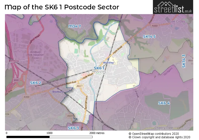
The largest settlements in the SK6 1 postal code are Woodley and Bredbury.
The SK6 1 Postcode shares a border with SK6 2 (Bredbury), SK6 3 (Romiley, STOCKPORT), SK6 4 (Romiley), SK14 5 (HYDE), M34 7 (Denton) and SK14 3 (HYDE, Broadbottom).
Map of the SK6 1 Postcode Sector
Explore the SK6 1 postcode sector by using our interactive map.
The sector is within the post town of STOCKPORT.
SK6 1 is a postcode sector within the SK6 postcode district which is within the SK Stockport postcode area.
The Royal Mail delivery office for the SK6 1 postal sector is the Bredbury Delivery Office.
The area of the SK6 1 postcode sector is 1.06 square miles which is 2.75 square kilometres or 679.60 square acres.
Waterways within the SK6 1 postcode sector include the Peak Forest Canal, River Tame.
Your support helps keep this site running!
If you enjoy using this website, consider buying me a coffee to help cover hosting costs.


| S | K | 6 | - | 1 | X | X |
| S | K | 6 | Space | 1 | Letter | Letter |
Official List of Streets
(3 Streets)
Woodley (91 Streets)
Bredbury (51 Streets)
Unofficial Streets or Alternative Spellings
Weather Forecast for SK6 1
Weather Forecast for Woodley
| Time Period | Icon | Description | Temperature | Rain Probability | Wind |
|---|---|---|---|---|---|
| 00:00 to 03:00 | Overcast | 7.0°C (feels like 3.0°C) | 8.00% | S 13 mph | |
| 03:00 to 06:00 | Overcast | 7.0°C (feels like 3.0°C) | 10.00% | S 13 mph | |
| 06:00 to 09:00 | Cloudy | 7.0°C (feels like 4.0°C) | 10.00% | S 16 mph | |
| 09:00 to 12:00 | Cloudy | 8.0°C (feels like 4.0°C) | 12.00% | S 18 mph | |
| 12:00 to 15:00 | Overcast | 9.0°C (feels like 5.0°C) | 49.00% | S 18 mph | |
| 15:00 to 18:00 | Heavy rain | 9.0°C (feels like 6.0°C) | 83.00% | SW 16 mph | |
| 18:00 to 21:00 | Light rain shower (night) | 7.0°C (feels like 4.0°C) | 37.00% | SW 13 mph | |
| 21:00 to 00:00 | Clear night | 6.0°C (feels like 2.0°C) | 2.00% | SW 11 mph |
| Time Period | Icon | Description | Temperature | Rain Probability | Wind |
|---|---|---|---|---|---|
| 00:00 to 03:00 | Clear night | 5.0°C (feels like 1.0°C) | 3.00% | SW 11 mph | |
| 03:00 to 06:00 | Clear night | 4.0°C (feels like 0.0°C) | 2.00% | SW 9 mph | |
| 06:00 to 09:00 | Partly cloudy (night) | 3.0°C (feels like 0.0°C) | 2.00% | WSW 9 mph | |
| 09:00 to 12:00 | Cloudy | 4.0°C (feels like 1.0°C) | 5.00% | SW 7 mph | |
| 12:00 to 15:00 | Cloudy | 7.0°C (feels like 4.0°C) | 5.00% | W 9 mph | |
| 15:00 to 18:00 | Cloudy | 7.0°C (feels like 5.0°C) | 4.00% | WNW 9 mph | |
| 18:00 to 21:00 | Clear night | 4.0°C (feels like 3.0°C) | 0.00% | WNW 4 mph | |
| 21:00 to 00:00 | Clear night | 2.0°C (feels like 1.0°C) | 1.00% | WSW 2 mph |
| Time Period | Icon | Description | Temperature | Rain Probability | Wind |
|---|---|---|---|---|---|
| 00:00 to 03:00 | Clear night | 1.0°C (feels like 0.0°C) | 1.00% | ESE 2 mph | |
| 03:00 to 06:00 | Clear night | 1.0°C (feels like -1.0°C) | 3.00% | ESE 2 mph | |
| 06:00 to 09:00 | Clear night | 0.0°C (feels like -2.0°C) | 5.00% | E 2 mph | |
| 09:00 to 12:00 | Sunny day | 1.0°C (feels like -1.0°C) | 3.00% | E 4 mph | |
| 12:00 to 15:00 | Sunny day | 6.0°C (feels like 4.0°C) | 0.00% | E 4 mph | |
| 15:00 to 18:00 | Sunny day | 7.0°C (feels like 5.0°C) | 0.00% | ESE 7 mph | |
| 18:00 to 21:00 | Clear night | 4.0°C (feels like 1.0°C) | 0.00% | E 7 mph | |
| 21:00 to 00:00 | Clear night | 3.0°C (feels like 0.0°C) | 0.00% | E 7 mph |
| Time Period | Icon | Description | Temperature | Rain Probability | Wind |
|---|---|---|---|---|---|
| 00:00 to 03:00 | Clear night | 2.0°C (feels like -1.0°C) | 0.00% | E 7 mph | |
| 03:00 to 06:00 | Clear night | 1.0°C (feels like -2.0°C) | 2.00% | E 7 mph | |
| 06:00 to 09:00 | Clear night | 1.0°C (feels like -2.0°C) | 3.00% | E 4 mph | |
| 09:00 to 12:00 | Partly cloudy (day) | 1.0°C (feels like -1.0°C) | 3.00% | ENE 4 mph | |
| 12:00 to 15:00 | Sunny day | 4.0°C (feels like 2.0°C) | 1.00% | E 7 mph | |
| 15:00 to 18:00 | Sunny day | 6.0°C (feels like 3.0°C) | 1.00% | E 7 mph | |
| 18:00 to 21:00 | Clear night | 3.0°C (feels like 1.0°C) | 1.00% | E 7 mph | |
| 21:00 to 00:00 | Clear night | 2.0°C (feels like -1.0°C) | 1.00% | E 7 mph |
Schools and Places of Education Within the SK6 1 Postcode Sector
Greave Primary School
Community school
Werneth Road, Stockport, Cheshire, SK6 1HR
Head: Mrs Jennie Williams
Ofsted Rating: Good
Inspection: 2022-07-07 (942 days ago)
Website: Visit Greave Primary School Website
Phone: 01614306318
Number of Pupils: 338
Woodley Primary School
Community school
Sherwood Road, Stockport, Cheshire, SK6 1LH
Head: Mr Peter Langridge
Ofsted Rating: Good
Inspection: 2021-10-13 (1209 days ago)
Website: Visit Woodley Primary School Website
Phone: 01614306609
Number of Pupils: 444
House Prices in the SK6 1 Postcode Sector
| Type of Property | 2018 Average | 2018 Sales | 2017 Average | 2017 Sales | 2016 Average | 2016 Sales | 2015 Average | 2015 Sales |
|---|---|---|---|---|---|---|---|---|
| Detached | £341,621 | 24 | £275,286 | 21 | £246,871 | 24 | £256,947 | 29 |
| Semi-Detached | £207,556 | 84 | £185,728 | 76 | £173,891 | 65 | £162,659 | 67 |
| Terraced | £160,410 | 29 | £143,165 | 41 | £137,508 | 36 | £133,324 | 43 |
| Flats | £95,746 | 14 | £86,146 | 12 | £75,861 | 14 | £82,844 | 8 |
Important Postcodes SK6 1 in the Postcode Sector
SK6 1BX is the postcode for St. Marks C of E Primary School, Redhouse Lane, Bredbury, and St. Marks C of E Primary School, Redhouse Lane
SK6 1DJ is the postcode for Stockport Metropolitan Borough Council, Bredbury Library, George Lane, and Werneth Young Peoples Centre, George Lane
SK6 1HR is the postcode for Greave Primary School, Werneth Road
SK6 1LH is the postcode for Woodley Primary School, Sherwood Road, and WOODLEY PRIMARY SCHOOL, SHERWOOD ROAD, WOODLEY
SK6 1ND is the postcode for Woodley Health Centre, Hyde Road, and Woodley Health Centre, Hyde Road, Woodley
SK6 1QG is the postcode for Woodley Civic Hall, Hyde Road
SK6 1QX is the postcode for Stockport Sports Village, Lambeth Grove, Woodley, and Stockport Sports Village, Lambeth Grove
| The SK6 1 Sector is within these Local Authorities |
|
|---|---|
| The SK6 1 Sector is within these Counties |
|
| The SK6 1 Sector is within these Water Company Areas |
|