A wide range of spatial data has been analysed to present this overview of the SK2 7 Postcode sector. If you would like anything added, please contact us.
The SK2 7 postcode sector is within the county of Greater Manchester.
Did you know? According to the 2021 Census, the SK2 7 postcode sector is home to a bustling 7,860 residents!
Given that each sector allows for 400 unique postcode combinations. Letters C, I, K, M, O and V are not allowed in the last two letters of a postcode. With 143 postcodes already in use, this leaves 257 units available.
The SK2 7 postal code covers the settlement of STOCKPORT.
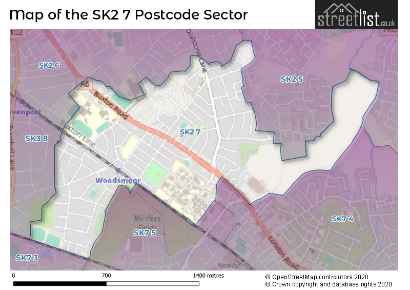
The SK2 7 Postcode shares a border with SK2 6 (STOCKPORT), SK3 8 (STOCKPORT), SK7 4 (Hazel Grove), SK7 5 (Hazel Grove), SK7 3 (Bramhall) and SK2 5 (STOCKPORT).
Map of the SK2 7 Postcode Sector
Explore the SK2 7 postcode sector by using our interactive map.
The sector is within the post town of STOCKPORT.
SK2 7 is a postcode sector within the SK2 postcode district which is within the SK Stockport postcode area.
The Royal Mail delivery office for the SK2 7 postal sector is the Stockport Central Delivery Office and Stockport 2 Delivery Office and Stockport 1 Delivery Office.
The area of the SK2 7 postcode sector is 0.71 square miles which is 1.85 square kilometres or 457.52 square acres.
Your support helps keep this site running!
If you enjoy using this website, consider buying me a coffee to help cover hosting costs.


| S | K | 2 | - | 7 | X | X |
| S | K | 2 | Space | 7 | Letter | Letter |
Official List of Streets
STOCKPORT (97 Streets)
(2 Streets)
Unofficial Streets or Alternative Spellings
Weather Forecast for SK2 7
Weather Forecast for Offerton
| Time Period | Icon | Description | Temperature | Rain Probability | Wind |
|---|---|---|---|---|---|
| 18:00 to 21:00 | Cloudy | 5.0°C (feels like 2.0°C) | 4.00% | SSE 9 mph | |
| 21:00 to 00:00 | Cloudy | 5.0°C (feels like 3.0°C) | 9.00% | SSE 9 mph |
| Time Period | Icon | Description | Temperature | Rain Probability | Wind |
|---|---|---|---|---|---|
| 00:00 to 03:00 | Overcast | 5.0°C (feels like 2.0°C) | 9.00% | SSE 11 mph | |
| 03:00 to 06:00 | Overcast | 5.0°C (feels like 1.0°C) | 10.00% | S 11 mph | |
| 06:00 to 09:00 | Overcast | 4.0°C (feels like 1.0°C) | 10.00% | S 9 mph | |
| 09:00 to 12:00 | Cloudy | 4.0°C (feels like 1.0°C) | 7.00% | S 9 mph | |
| 12:00 to 15:00 | Cloudy | 6.0°C (feels like 3.0°C) | 5.00% | S 11 mph | |
| 15:00 to 18:00 | Overcast | 7.0°C (feels like 4.0°C) | 12.00% | S 9 mph | |
| 18:00 to 21:00 | Overcast | 6.0°C (feels like 4.0°C) | 11.00% | S 7 mph | |
| 21:00 to 00:00 | Cloudy | 6.0°C (feels like 3.0°C) | 8.00% | S 7 mph |
| Time Period | Icon | Description | Temperature | Rain Probability | Wind |
|---|---|---|---|---|---|
| 00:00 to 03:00 | Overcast | 5.0°C (feels like 3.0°C) | 9.00% | S 7 mph | |
| 03:00 to 06:00 | Overcast | 5.0°C (feels like 2.0°C) | 8.00% | S 7 mph | |
| 06:00 to 09:00 | Cloudy | 4.0°C (feels like 1.0°C) | 5.00% | S 9 mph | |
| 09:00 to 12:00 | Cloudy | 4.0°C (feels like 1.0°C) | 5.00% | S 9 mph | |
| 12:00 to 15:00 | Cloudy | 7.0°C (feels like 4.0°C) | 4.00% | S 11 mph | |
| 15:00 to 18:00 | Cloudy | 9.0°C (feels like 6.0°C) | 4.00% | S 11 mph | |
| 18:00 to 21:00 | Cloudy | 7.0°C (feels like 4.0°C) | 5.00% | S 11 mph | |
| 21:00 to 00:00 | Partly cloudy (night) | 6.0°C (feels like 3.0°C) | 2.00% | S 13 mph |
| Time Period | Icon | Description | Temperature | Rain Probability | Wind |
|---|---|---|---|---|---|
| 00:00 to 03:00 | Cloudy | 7.0°C (feels like 3.0°C) | 5.00% | S 13 mph | |
| 03:00 to 06:00 | Overcast | 7.0°C (feels like 3.0°C) | 8.00% | S 13 mph | |
| 06:00 to 09:00 | Cloudy | 7.0°C (feels like 4.0°C) | 9.00% | S 13 mph | |
| 09:00 to 12:00 | Cloudy | 8.0°C (feels like 4.0°C) | 18.00% | S 16 mph | |
| 12:00 to 15:00 | Light rain | 9.0°C (feels like 6.0°C) | 55.00% | SSW 16 mph | |
| 15:00 to 18:00 | Light rain | 9.0°C (feels like 7.0°C) | 53.00% | SW 11 mph | |
| 18:00 to 21:00 | Cloudy | 8.0°C (feels like 5.0°C) | 13.00% | SW 11 mph | |
| 21:00 to 00:00 | Clear night | 6.0°C (feels like 3.0°C) | 7.00% | SW 9 mph |
| Time Period | Icon | Description | Temperature | Rain Probability | Wind |
|---|---|---|---|---|---|
| 00:00 to 03:00 | Clear night | 5.0°C (feels like 2.0°C) | 4.00% | WSW 9 mph | |
| 03:00 to 06:00 | Clear night | 4.0°C (feels like 1.0°C) | 2.00% | WSW 7 mph | |
| 06:00 to 09:00 | Clear night | 3.0°C (feels like 0.0°C) | 2.00% | SW 7 mph | |
| 09:00 to 12:00 | Cloudy | 3.0°C (feels like 2.0°C) | 5.00% | SW 4 mph | |
| 12:00 to 15:00 | Cloudy | 6.0°C (feels like 5.0°C) | 4.00% | WSW 4 mph | |
| 15:00 to 18:00 | Cloudy | 7.0°C (feels like 6.0°C) | 4.00% | W 4 mph | |
| 18:00 to 21:00 | Clear night | 4.0°C (feels like 2.0°C) | 1.00% | SSW 4 mph | |
| 21:00 to 00:00 | Clear night | 2.0°C (feels like 0.0°C) | 1.00% | SSE 4 mph |
Schools and Places of Education Within the SK2 7 Postcode Sector
Great Moor Infant School
Community school
Southwood Road, Stockport, Cheshire, SK2 7DG
Head: Mrs Yvonne Dobson
Ofsted Rating: Requires improvement
Inspection: 2021-11-24 (1165 days ago)
Website: Visit Great Moor Infant School Website
Phone: 01614830242
Number of Pupils: 275
Great Moor Junior School
Community school
Great Moor Junior School, Stockport, Cheshire, SK2 7DG
Head: Mrs Kate Bushaway
Ofsted Rating: Good
Inspection: 2022-07-06 (941 days ago)
Website: Visit Great Moor Junior School Website
Phone: 01614834987
Number of Pupils: 312
House Prices in the SK2 7 Postcode Sector
| Type of Property | 2018 Average | 2018 Sales | 2017 Average | 2017 Sales | 2016 Average | 2016 Sales | 2015 Average | 2015 Sales |
|---|---|---|---|---|---|---|---|---|
| Detached | £343,532 | 14 | £341,953 | 22 | £318,832 | 66 | £272,540 | 45 |
| Semi-Detached | £235,214 | 88 | £231,748 | 89 | £218,916 | 98 | £197,853 | 85 |
| Terraced | £167,935 | 40 | £167,442 | 70 | £140,494 | 50 | £122,516 | 44 |
| Flats | £135,295 | 10 | £111,118 | 17 | £105,500 | 10 | £94,800 | 25 |
Important Postcodes SK2 7 in the Postcode Sector
SK2 7DG is the postcode for Great Moor Infant School, Southwood Road, and Great Moor Junior School, Southwood Road
SK2 7JE is the postcode for DEPARTMENT OF MEDICINE FOR OLDER PEOPLE, Stockport NHS Foundation Trust, Stepping Hill Hospital, Poplar Grove, CARDIAC & SURGERY UNIT (BLOCK 94), Stockport NHS Foundation Trust, Stepping Hill Hospital, Poplar Grove, A12, A14, A15 (BLOCKS 9, 10, 11), Stockport NHS Foundation Trust, Stepping Hill Hospital, Poplar Grove, PHASE 1, Stockport NHS Foundation Trust, Stepping Hill Hospital, Poplar Grove, MAIN HOSPITAL BLOCKS (BLOCKS 32-51), Stockport NHS Foundation Trust, Stepping Hill Hospital, Poplar Grove, PHARMACY (BLOCK 68), Stockport NHS Foundation Trust, Stepping Hill Hospital, Poplar Grove, OPDB (BLOCK 1, 2, 3), Stockport NHS Foundation Trust, Stepping Hill Hospital, Poplar Grove, NEONATAL, Stockport NHS Foundation Trust, Stepping Hill Hospital, Poplar Grove, PINEWOOD (BLOCK 73), Stockport NHS Foundation Trust, Stepping Hill Hospital, Poplar Grove, SOUTHERN SECTOR PHASE 1 (BLOCK 85), Stockport NHS Foundation Trust, Stepping Hill Hospital, Poplar Grove, MAIN HOSPITAL BLOCKS, Stockport NHS Foundation Trust, Stepping Hill Hospital, Poplar Grove, CARDIAC & SURGERY UNIT, Stockport NHS Foundation Trust, Stepping Hill Hospital, Poplar Grove, BLOCK 85, Stockport NHS Foundation Trust, Stepping Hill Hospital, Poplar Grove, PINEWOOD HOUSE, Stockport NHS Foundation Trust, Stepping Hill Hospital, Poplar Grove, DEPARTMENT OF MEDICINE FOR OLDER PEOPLE (BLOCK 90), Stockport NHS Foundation Trust, Stepping Hill Hospital, Poplar Grove, WOODLANDS, Stockport NHS Foundation Trust, Stepping Hill Hospital, Poplar Grove, PHASE 1 (BLOCKS 81, 82, 83), Stockport NHS Foundation Trust, Stepping Hill Hospital, Poplar Grove, OPDB, Stockport NHS Foundation Trust, Stepping Hill Hospital, Poplar Grove, WOMENS UNIT, Stockport NHS Foundation Trust, Stepping Hill Hospital, Poplar Grove, WOODLANDS (BLOCK 15), Stockport NHS Foundation Trust, Stepping Hill Hospital, Poplar Grove, OASIS (MENTAL HEALTH BUILDING), Stepping Hill Hospital, Poplar Grove, PHARMACY, Stockport NHS Foundation Trust, Stepping Hill Hospital, Poplar Grove, TREEHOUSE CHILDRENS' UNIT, Stockport NHS Foundation Trust, Stepping Hill Hospital, Poplar Grove, Oasis Building, Stepping Hill Hospital, Poplar Grove, Stepping Hill Hospital, Poplar Grove, 4 MED BLOCK, Stockport NHS Foundation Trust, Stepping Hill Hospital, Poplar Grove, TREEHOUSE (BLOCK 67), Stockport NHS Foundation Trust, Stepping Hill Hospital, Poplar Grove, WOMEN & CHILDREN'S/NEONATAL (BLOCK 64, 65, 66), Stockport NHS Foundation Trust, Stepping Hill Hospital, Poplar Grove, and Stockport NHS Foundation Trust, Stepping Hill Hospital, Poplar Grove
SK2 7LL is the postcode for Stockport Metropolitan Borough Council, Lisburne Lane
SK2 7PZ is the postcode for Stockport NHS Foundation Trust, Cherry Tree Hospital, and DEVONSHIRE CENTRE, Cherry Tree Hospital, Cherry Tree Lane
| The SK2 7 Sector is within these Local Authorities |
|
|---|---|
| The SK2 7 Sector is within these Counties |
|
| The SK2 7 Sector is within these Water Company Areas |
|