A wide range of spatial data has been analysed to present this overview of the SK2 6 Postcode sector. If you would like anything added, please contact us.
The SK2 6 postcode sector is within the county of Greater Manchester.
Did you know? According to the 2021 Census, the SK2 6 postcode sector is home to a bustling 8,321 residents!
Given that each sector allows for 400 unique postcode combinations. Letters C, I, K, M, O and V are not allowed in the last two letters of a postcode. With 175 postcodes already in use, this leaves 225 units available.
The SK2 6 postal code covers the settlement of STOCKPORT.
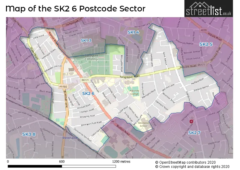
The SK2 6 Postcode shares a border with SK3 8 (STOCKPORT), SK2 7 (STOCKPORT), SK1 3 (STOCKPORT), SK1 4 (STOCKPORT) and SK2 5 (STOCKPORT).
Map of the SK2 6 Postcode Sector
Explore the SK2 6 postcode sector by using our interactive map.
The sector is within the post town of STOCKPORT.
SK2 6 is a postcode sector within the SK2 postcode district which is within the SK Stockport postcode area.
The Royal Mail delivery office for the SK2 6 postal sector is the Stockport Central Delivery Office and Stockport 2 Delivery Office and Stockport 1 Delivery Office.
The area of the SK2 6 postcode sector is 0.59 square miles which is 1.52 square kilometres or 375.87 square acres.
Your support helps keep this site running!
If you enjoy using this website, consider buying me a coffee to help cover hosting costs.


| S | K | 2 | - | 6 | X | X |
| S | K | 2 | Space | 6 | Letter | Letter |
Official List of Streets
STOCKPORT (103 Streets)
Davenport Park (1 Streets)
Unofficial Streets or Alternative Spellings
STOCKPORT
BEECH AVENUE CHORLTON GROVE DAISY STREET GIPSY LANE GUILDFORD CLOSE HEATHLAND TERRACE HEMPSHAW LANE HIGHER HILLGATE HILLCREST ROAD JUNCTION ROAD KNYPERSLEY AVENUE MARSLAND TERRACE MEYER STREET RAISBECK ROAD SANDHURST ROAD SHAW ROAD SOUTH THOMAS STREET WEST WHISTLE HOLLOW WAY WINDERMERE ROAD BAMPTON CLOSE DEVONSHIRE ROAD GARNERS LANE HALLAMS PASSAGE LEYBURNE AVENUE RUTLAND COURTWeather Forecast for SK2 6
Weather Forecast for Davenport
| Time Period | Icon | Description | Temperature | Rain Probability | Wind |
|---|---|---|---|---|---|
| 03:00 to 06:00 | Heavy rain | 4.0°C (feels like 0.0°C) | 94.00% | S 11 mph | |
| 06:00 to 09:00 | Light rain | 5.0°C (feels like 2.0°C) | 60.00% | WSW 7 mph | |
| 09:00 to 12:00 | Overcast | 5.0°C (feels like 3.0°C) | 10.00% | W 7 mph | |
| 12:00 to 15:00 | Overcast | 7.0°C (feels like 4.0°C) | 8.00% | NNW 7 mph | |
| 15:00 to 18:00 | Overcast | 7.0°C (feels like 5.0°C) | 9.00% | N 4 mph | |
| 18:00 to 21:00 | Cloudy | 5.0°C (feels like 4.0°C) | 5.00% | NNE 4 mph | |
| 21:00 to 00:00 | Cloudy | 4.0°C (feels like 2.0°C) | 10.00% | SSE 4 mph |
| Time Period | Icon | Description | Temperature | Rain Probability | Wind |
|---|---|---|---|---|---|
| 00:00 to 03:00 | Overcast | 4.0°C (feels like 3.0°C) | 10.00% | SSE 4 mph | |
| 03:00 to 06:00 | Overcast | 4.0°C (feels like 2.0°C) | 11.00% | SSE 4 mph | |
| 06:00 to 09:00 | Cloudy | 3.0°C (feels like 1.0°C) | 16.00% | SSE 4 mph | |
| 09:00 to 12:00 | Overcast | 3.0°C (feels like 0.0°C) | 9.00% | SSE 7 mph | |
| 12:00 to 15:00 | Overcast | 5.0°C (feels like 2.0°C) | 9.00% | S 11 mph | |
| 15:00 to 18:00 | Overcast | 6.0°C (feels like 3.0°C) | 9.00% | S 11 mph | |
| 18:00 to 21:00 | Cloudy | 5.0°C (feels like 2.0°C) | 7.00% | SSE 11 mph | |
| 21:00 to 00:00 | Cloudy | 5.0°C (feels like 1.0°C) | 5.00% | SSE 11 mph |
| Time Period | Icon | Description | Temperature | Rain Probability | Wind |
|---|---|---|---|---|---|
| 00:00 to 03:00 | Cloudy | 4.0°C (feels like 0.0°C) | 6.00% | SSE 11 mph | |
| 03:00 to 06:00 | Cloudy | 4.0°C (feels like 0.0°C) | 10.00% | SSE 11 mph | |
| 06:00 to 09:00 | Overcast | 4.0°C (feels like 0.0°C) | 23.00% | S 9 mph | |
| 09:00 to 12:00 | Overcast | 4.0°C (feels like 1.0°C) | 22.00% | S 9 mph | |
| 12:00 to 15:00 | Overcast | 6.0°C (feels like 3.0°C) | 15.00% | SSW 9 mph | |
| 15:00 to 18:00 | Overcast | 6.0°C (feels like 4.0°C) | 13.00% | SSW 7 mph | |
| 18:00 to 21:00 | Cloudy | 5.0°C (feels like 3.0°C) | 8.00% | SW 4 mph | |
| 21:00 to 00:00 | Cloudy | 4.0°C (feels like 2.0°C) | 6.00% | SSW 4 mph |
| Time Period | Icon | Description | Temperature | Rain Probability | Wind |
|---|---|---|---|---|---|
| 00:00 to 03:00 | Overcast | 3.0°C (feels like 1.0°C) | 8.00% | S 4 mph | |
| 03:00 to 06:00 | Cloudy | 3.0°C (feels like 1.0°C) | 5.00% | S 4 mph | |
| 06:00 to 09:00 | Cloudy | 3.0°C (feels like 0.0°C) | 5.00% | SSE 7 mph | |
| 09:00 to 12:00 | Cloudy | 4.0°C (feels like 1.0°C) | 5.00% | SSE 7 mph | |
| 12:00 to 15:00 | Cloudy | 6.0°C (feels like 4.0°C) | 5.00% | S 9 mph | |
| 15:00 to 18:00 | Cloudy | 8.0°C (feels like 5.0°C) | 4.00% | S 11 mph | |
| 18:00 to 21:00 | Cloudy | 6.0°C (feels like 3.0°C) | 5.00% | S 11 mph | |
| 21:00 to 00:00 | Cloudy | 6.0°C (feels like 2.0°C) | 5.00% | S 11 mph |
Schools and Places of Education Within the SK2 6 Postcode Sector
Aquinas College
Further education
Nangreave Road, Stockport, Cheshire, SK2 6TH
Head: Mr Danny Pearson
Ofsted Rating: Good
Inspection: 2023-04-28 (644 days ago)
Website: Visit Aquinas College Website
Phone: 01614833237
Number of Pupils: 0
St George's Church of England Primary School
Voluntary aided school
Buxton Road, Stockport, Cheshire, SK2 6NX
Head: Mrs Debbie Grindrod
Ofsted Rating: Requires improvement
Inspection: 2023-07-12 (569 days ago)
Website: Visit St George's Church of England Primary School Website
Phone: 01614808657
Number of Pupils: 374
Stockport School
Community school
Mile End Lane, Stockport, Cheshire, SK2 6BW
Head: Mr Ian Irwin
Ofsted Rating: Good
Inspection: 2019-12-11 (1878 days ago)
Website: Visit Stockport School Website
Phone: 01614833622
Number of Pupils: 1294
House Prices in the SK2 6 Postcode Sector
| Type of Property | 2018 Average | 2018 Sales | 2017 Average | 2017 Sales | 2016 Average | 2016 Sales | 2015 Average | 2015 Sales |
|---|---|---|---|---|---|---|---|---|
| Detached | £360,165 | 12 | £285,583 | 6 | £292,400 | 5 | £294,500 | 4 |
| Semi-Detached | £261,246 | 57 | £248,296 | 82 | £230,642 | 57 | £204,460 | 62 |
| Terraced | £169,455 | 54 | £156,969 | 53 | £143,327 | 81 | £136,420 | 64 |
| Flats | £125,800 | 10 | £98,423 | 20 | £102,468 | 19 | £105,962 | 13 |
Important Postcodes SK2 6 in the Postcode Sector
SK2 6BW is the postcode for J BLOCK, Stockport School, Mile End Lane, MAIN BUILDING, Stockport School, Mile End Lane, SPORTS CENTRE, Stockport School, Mile End Lane, and Stockport School, Mile End Lane
SK2 6NX is the postcode for St. Georges C of E Junior School, Buxton Road, JUNIOR BUILDING, St George's Church of England Primary School, Buxton Road, INFANT BUILDING, St George's Church of England Primary School, Buxton Road, and MIDDLE BUILDING, St George's Church of England Primary School, Buxton Road
SK2 6RA is the postcode for Pennine Care NHS Foundation Trust, Heathfield House
SK2 6RE is the postcode for PROGRESS HOUSE, 35A ADSWOOD LANE EAST, CALE GREEN
SK2 6TH is the postcode for SPORTS HALL, Aquinas Sixth Form College, Nangreave Road, and Aquinas Sixth Form College, Nangreave Road
| The SK2 6 Sector is within these Local Authorities |
|
|---|---|
| The SK2 6 Sector is within these Counties |
|
| The SK2 6 Sector is within these Water Company Areas |
|