A wide range of spatial data has been analysed to present this overview of the SK17 0 Postcode sector. If you would like anything added, please contact us.
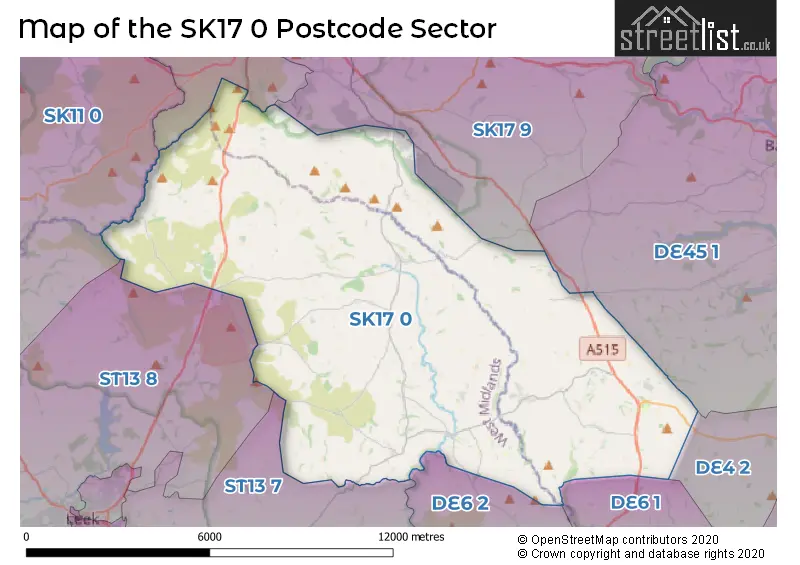
The SK17 0 postcode sector lies where the three counties of Derbyshire, Staffordshire, and Cheshire meet.
Did you know? According to the 2021 Census, the SK17 0 postcode sector is home to a bustling 2,719 residents!
Given that each sector allows for 400 unique postcode combinations. Letters C, I, K, M, O and V are not allowed in the last two letters of a postcode. With 195 postcodes already in use, this leaves 205 units available.
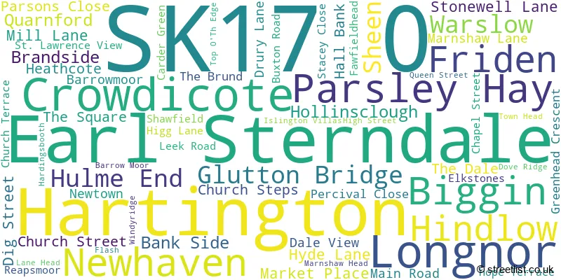
The largest settlement in the SK17 0 postal code is Longnor followed by Hartington, and Quarnford.
The SK17 0 Postcode shares a border with SK11 0 (Sutton, Rushton Spencer, Langley), DE4 2 (Darley Dale, Winster, Bonsall), DE45 1 (BAKEWELL, Youlgrave, Baslow), SK17 6 (BUXTON, Ladmanlow), SK17 9 (BUXTON, Taddington, Flagg), ST13 7 (Cheddleton, LEEK, Bradnop), ST13 8 (LEEK, Rudyard, Upper Hulme), DE6 1 (ASHBOURNE, Parwich, Kniveton) and DE6 2 (Mayfield, Marston Montgomery, Alstonefield).
Map of the SK17 0 Postcode Sector
Explore the SK17 0 postcode sector by using our interactive map.
The sector is within the post town of BUXTON.
SK17 0 is a postcode sector within the SK17 postcode district which is within the SK Stockport postcode area.
The Royal Mail delivery office for the SK17 0 postal sector is the Buxton (sk) Delivery Office.
The area of the SK17 0 postcode sector is 53.78 square miles which is 139.29 square kilometres or 34,420.05 square acres.
Waterways within the SK17 0 postcode sector include the River Dane, Black Brook, River Dove.
Your support helps keep this site running!
If you enjoy using this website, consider buying me a coffee to help cover hosting costs.

| S | K | 1 | 7 | - | 0 | X | X |
| S | K | 1 | 7 | Space | 0 | Letter | Letter |
Official List of Streets
(92 Streets)
Hartington (12 Streets)
Longnor (25 Streets)
Biggin (3 Streets)
Warslow (3 Streets)
Unofficial Streets or Alternative Spellings
Middleton-by-Youlgrave
LONG RAKEMonyash
TAGG LANENewton Grange
BUXTON ROADWarslow
CHURCH TERRACEWeather Forecast for SK17 0
Weather Forecast for Hartington Hall Youth Hostel
| Time Period | Icon | Description | Temperature | Rain Probability | Wind |
|---|---|---|---|---|---|
| 03:00 to 06:00 | Fog | 4.0°C (feels like 1.0°C) | 19.00% | SW 7 mph | |
| 06:00 to 09:00 | Fog | 4.0°C (feels like 1.0°C) | 19.00% | SW 9 mph | |
| 09:00 to 12:00 | Cloudy | 4.0°C (feels like 0.0°C) | 8.00% | SSW 9 mph | |
| 12:00 to 15:00 | Cloudy | 6.0°C (feels like 2.0°C) | 5.00% | SSW 11 mph | |
| 15:00 to 18:00 | Cloudy | 7.0°C (feels like 3.0°C) | 5.00% | SSW 11 mph | |
| 18:00 to 21:00 | Cloudy | 5.0°C (feels like 1.0°C) | 5.00% | SSW 11 mph | |
| 21:00 to 00:00 | Cloudy | 5.0°C (feels like 1.0°C) | 5.00% | SSW 13 mph |
| Time Period | Icon | Description | Temperature | Rain Probability | Wind |
|---|---|---|---|---|---|
| 00:00 to 03:00 | Cloudy | 5.0°C (feels like 0.0°C) | 6.00% | SSW 16 mph | |
| 03:00 to 06:00 | Cloudy | 5.0°C (feels like 1.0°C) | 9.00% | SSW 16 mph | |
| 06:00 to 09:00 | Overcast | 6.0°C (feels like 1.0°C) | 11.00% | SSW 18 mph | |
| 09:00 to 12:00 | Overcast | 6.0°C (feels like 2.0°C) | 18.00% | SSW 18 mph | |
| 12:00 to 15:00 | Light rain | 7.0°C (feels like 3.0°C) | 59.00% | SSW 18 mph | |
| 15:00 to 18:00 | Heavy rain | 8.0°C (feels like 4.0°C) | 88.00% | SW 16 mph | |
| 18:00 to 21:00 | Light rain shower (night) | 6.0°C (feels like 3.0°C) | 39.00% | SW 13 mph | |
| 21:00 to 00:00 | Clear night | 5.0°C (feels like 1.0°C) | 7.00% | WSW 13 mph |
| Time Period | Icon | Description | Temperature | Rain Probability | Wind |
|---|---|---|---|---|---|
| 00:00 to 03:00 | Clear night | 4.0°C (feels like -1.0°C) | 4.00% | WSW 13 mph | |
| 03:00 to 06:00 | Clear night | 3.0°C (feels like -2.0°C) | 2.00% | W 13 mph | |
| 06:00 to 09:00 | Partly cloudy (night) | 2.0°C (feels like -2.0°C) | 2.00% | W 11 mph | |
| 09:00 to 12:00 | Cloudy | 2.0°C (feels like -1.0°C) | 5.00% | WSW 9 mph | |
| 12:00 to 15:00 | Cloudy | 5.0°C (feels like 1.0°C) | 5.00% | W 11 mph | |
| 15:00 to 18:00 | Cloudy | 5.0°C (feels like 2.0°C) | 4.00% | WNW 9 mph | |
| 18:00 to 21:00 | Clear night | 2.0°C (feels like -1.0°C) | 1.00% | W 4 mph | |
| 21:00 to 00:00 | Clear night | 0.0°C (feels like -2.0°C) | 1.00% | W 4 mph |
| Time Period | Icon | Description | Temperature | Rain Probability | Wind |
|---|---|---|---|---|---|
| 00:00 to 03:00 | Clear night | -1.0°C (feels like -3.0°C) | 1.00% | W 2 mph | |
| 03:00 to 06:00 | Clear night | -1.0°C (feels like -3.0°C) | 2.00% | NNW 2 mph | |
| 06:00 to 09:00 | Clear night | -2.0°C (feels like -3.0°C) | 2.00% | N 2 mph | |
| 09:00 to 12:00 | Sunny day | 1.0°C (feels like -1.0°C) | 2.00% | NNE 2 mph | |
| 12:00 to 15:00 | Sunny day | 5.0°C (feels like 3.0°C) | 1.00% | E 7 mph | |
| 15:00 to 18:00 | Sunny day | 5.0°C (feels like 3.0°C) | 1.00% | E 7 mph | |
| 18:00 to 21:00 | Clear night | 1.0°C (feels like -2.0°C) | 1.00% | E 4 mph | |
| 21:00 to 00:00 | Clear night | 0.0°C (feels like -3.0°C) | 1.00% | E 7 mph |
Schools and Places of Education Within the SK17 0 Postcode Sector
Biggin CofE Primary School
Voluntary controlled school
Main Street, Buxton, Derbyshire, SK17 0DQ
Head: Ms Teresa Nicholls
Ofsted Rating: Good
Inspection: 2022-10-11 (846 days ago)
Website: Visit Biggin CofE Primary School Website
Phone: 0129884279
Number of Pupils: 19
Bradshaw Farm Independent School
Other independent special school
, Buxton, Derbyshire, SK17 0QY
Head: Mrs Diane Wood
Ofsted Rating: Requires improvement
Inspection: 2022-07-06 (943 days ago)
Website: Visit Bradshaw Farm Independent School Website
Phone: 0129823140
Number of Pupils: 3
Earl Sterndale CofE Primary School
Voluntary controlled school
Earl Sterndale, Buxton, Derbyshire, SK17 0BS
Head: Mr Daniel Holden
Ofsted Rating: Good
Inspection: 2019-01-09 (2217 days ago)
Website: Visit Earl Sterndale CofE Primary School Website
Phone: 0129883263
Number of Pupils: 33
Hartington CofE Primary School
Voluntary controlled school
The Dale, Buxton, Derbyshire, SK17 0AS
Head: Mrs Tracy Blackwell
Ofsted Rating: Good
Inspection: 2023-02-14 (720 days ago)
Website: Visit Hartington CofE Primary School Website
Phone: 0129884254
Number of Pupils: 23
Hollinsclough Church of England Academy
Academy converter
Carr Lane, Buxton, Staffordshire, SK17 0RH
Head: Mrs Lynda O'Sullivan
Ofsted Rating: Good
Inspection: 2023-11-09 (452 days ago)
Website: Visit Hollinsclough Church of England Academy Website
Phone: 0129883303
Number of Pupils: 30
Manifold Church of England Primary School
Academy converter
Off Leek Road, Buxton, Derbyshire, SK17 0JP
Head: Kelly Stanesby
Ofsted Rating: Good
Inspection: 2018-06-20 (2420 days ago)
Website: Visit Manifold Church of England Primary School Website
Phone: 01298384293
Number of Pupils: 50
Old Sams Farm Independent School
Other independent special school
Old Sams Farm, Buxton, Derbyshire, SK17 0SN
Head: Mrs Diane Wood
Ofsted Rating: Good
Inspection: 2022-10-05 (852 days ago)
Website: Visit Old Sams Farm Independent School Website
Phone: 01298214568
Number of Pupils: 4
St Bartholomew's CofE (C) School
Voluntary controlled school
Buxton Road, Buxton, Derbyshire, SK17 0NZ
Head: Miss E Priestman
Ofsted Rating: Requires improvement
Inspection: 2023-03-22 (684 days ago)
Website: Visit St Bartholomew's CofE (C) School Website
Phone: 0129883233
Number of Pupils: 44
House Prices in the SK17 0 Postcode Sector
| Type of Property | 2018 Average | 2018 Sales | 2017 Average | 2017 Sales | 2016 Average | 2016 Sales | 2015 Average | 2015 Sales |
|---|---|---|---|---|---|---|---|---|
| Detached | £450,731 | 13 | £364,182 | 11 | £360,577 | 13 | £312,998 | 22 |
| Semi-Detached | £206,992 | 6 | £191,778 | 9 | £228,750 | 8 | £194,632 | 11 |
| Terraced | £156,286 | 7 | £203,625 | 8 | £180,000 | 2 | £175,800 | 5 |
| Flats | £118,000 | 1 | £0 | 0 | £265,000 | 1 | £0 | 0 |
Important Postcodes SK17 0 in the Postcode Sector
SK17 0AQ is the postcode for Hartington Surgery, Dig Street
SK17 0JR is the postcode for Staffordshire County Council, Manifold County Primary School,
| The SK17 0 Sector is within these Local Authorities |
|
|---|---|
| The SK17 0 Sector is within these Counties |
|
| The SK17 0 Sector is within these Water Company Areas |
|