A wide range of spatial data has been analysed to present this overview of the SK11 9 Postcode sector. If you would like anything added, please contact us.
The SK11 9 postcode sector is within the county of Cheshire.
Did you know? According to the 2021 Census, the SK11 9 postcode sector is home to a bustling 4,428 residents!
Given that each sector allows for 400 unique postcode combinations. Letters C, I, K, M, O and V are not allowed in the last two letters of a postcode. With 202 postcodes already in use, this leaves 198 units available.
The largest settlement in the SK11 9 postal code is Chelford followed by Gawsworth, and Lower Withington.
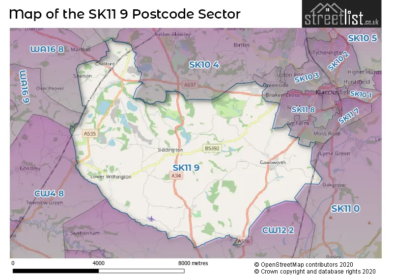
The SK11 9 Postcode shares a border with SK10 3 (MACCLESFIELD), SK10 4 (Prestbury, Nether Alderley, Adlington), SK11 0 (Sutton, Rushton Spencer, Langley), SK11 7 (MACCLESFIELD, Gawsworth), SK11 8 (MACCLESFIELD), SK9 7 (ALDERLEY EDGE), WA16 8 (KNUTSFORD, Ollerton, Over Peover), WA16 9 (KNUTSFORD, Allostock, Lower Peover), CW4 8 (Goostrey, Holmes Chapel, Cranage) and CW12 2 (CONGLETON, Eaton, North Rode).
Map of the SK11 9 Postcode Sector
Explore the SK11 9 postcode sector by using our interactive map.
The sector is within the post town of MACCLESFIELD.
SK11 9 is a postcode sector within the SK11 postcode district which is within the SK Stockport postcode area.
The Royal Mail delivery office for the SK11 9 postal sector is the Macclesfield Delivery Office.
The area of the SK11 9 postcode sector is 25.32 square miles which is 65.57 square kilometres or 16,202.47 square acres.
Your support helps keep this site running!
If you enjoy using this website, consider buying me a coffee to help cover hosting costs.


| S | K | 1 | 1 | - | 9 | X | X |
| S | K | 1 | 1 | Space | 9 | Letter | Letter |
Official List of Streets
Chelford (37 Streets)
Henbury (17 Streets)
Gawsworth (27 Streets)
(13 Streets)
Siddington (16 Streets)
Lower Withington (18 Streets)
Marton (9 Streets)
Snelson (6 Streets)
North Rode (3 Streets)
MACCLESFIELD (1 Streets)
Marthall (1 Streets)
Unofficial Streets or Alternative Spellings
Gawsworth
COWBROOK LANE ASTLE COURT BACK LANE BOUNDARY LANE LONG LANE MACCLESFIELD SOUTHERN LINK ROAD MESSUAGE LANE NATURE WALK WELL BANK LANE WOODLAND ENDSomerford Booths
TRAP ROADEaton
MACCLESFIELD ROADALDERLEY EDGE
CHELFORD ROADMarthall
CHELFORD ROADOver Peover
BOUNDARY LANEWeather Forecast for SK11 9
Weather Forecast for Capesthorne Hall
| Time Period | Icon | Description | Temperature | Rain Probability | Wind |
|---|---|---|---|---|---|
| 06:00 to 09:00 | Overcast | 4.0°C (feels like 0.0°C) | 9.00% | S 13 mph | |
| 09:00 to 12:00 | Cloudy | 4.0°C (feels like 0.0°C) | 6.00% | S 11 mph | |
| 12:00 to 15:00 | Cloudy | 6.0°C (feels like 2.0°C) | 5.00% | S 13 mph | |
| 15:00 to 18:00 | Overcast | 7.0°C (feels like 4.0°C) | 12.00% | S 9 mph | |
| 18:00 to 21:00 | Overcast | 6.0°C (feels like 3.0°C) | 11.00% | SSE 7 mph | |
| 21:00 to 00:00 | Cloudy | 5.0°C (feels like 3.0°C) | 5.00% | S 7 mph |
| Time Period | Icon | Description | Temperature | Rain Probability | Wind |
|---|---|---|---|---|---|
| 00:00 to 03:00 | Overcast | 5.0°C (feels like 3.0°C) | 9.00% | S 7 mph | |
| 03:00 to 06:00 | Overcast | 5.0°C (feels like 2.0°C) | 8.00% | S 7 mph | |
| 06:00 to 09:00 | Cloudy | 4.0°C (feels like 0.0°C) | 5.00% | S 9 mph | |
| 09:00 to 12:00 | Cloudy | 4.0°C (feels like 0.0°C) | 5.00% | S 9 mph | |
| 12:00 to 15:00 | Cloudy | 7.0°C (feels like 4.0°C) | 4.00% | S 11 mph | |
| 15:00 to 18:00 | Cloudy | 9.0°C (feels like 6.0°C) | 4.00% | S 11 mph | |
| 18:00 to 21:00 | Cloudy | 7.0°C (feels like 4.0°C) | 5.00% | S 11 mph | |
| 21:00 to 00:00 | Partly cloudy (night) | 6.0°C (feels like 3.0°C) | 2.00% | S 13 mph |
| Time Period | Icon | Description | Temperature | Rain Probability | Wind |
|---|---|---|---|---|---|
| 00:00 to 03:00 | Cloudy | 7.0°C (feels like 3.0°C) | 5.00% | S 13 mph | |
| 03:00 to 06:00 | Overcast | 7.0°C (feels like 3.0°C) | 8.00% | S 13 mph | |
| 06:00 to 09:00 | Overcast | 7.0°C (feels like 3.0°C) | 12.00% | S 16 mph | |
| 09:00 to 12:00 | Cloudy | 8.0°C (feels like 4.0°C) | 18.00% | S 16 mph | |
| 12:00 to 15:00 | Light rain | 9.0°C (feels like 6.0°C) | 55.00% | SSW 16 mph | |
| 15:00 to 18:00 | Light rain | 9.0°C (feels like 7.0°C) | 53.00% | SW 11 mph | |
| 18:00 to 21:00 | Cloudy | 8.0°C (feels like 5.0°C) | 13.00% | SW 11 mph | |
| 21:00 to 00:00 | Clear night | 6.0°C (feels like 3.0°C) | 7.00% | SW 9 mph |
| Time Period | Icon | Description | Temperature | Rain Probability | Wind |
|---|---|---|---|---|---|
| 00:00 to 03:00 | Clear night | 5.0°C (feels like 2.0°C) | 4.00% | WSW 9 mph | |
| 03:00 to 06:00 | Clear night | 4.0°C (feels like 1.0°C) | 3.00% | WSW 7 mph | |
| 06:00 to 09:00 | Clear night | 3.0°C (feels like 0.0°C) | 2.00% | SW 7 mph | |
| 09:00 to 12:00 | Cloudy | 3.0°C (feels like 1.0°C) | 5.00% | SW 4 mph | |
| 12:00 to 15:00 | Cloudy | 6.0°C (feels like 5.0°C) | 4.00% | WSW 4 mph | |
| 15:00 to 18:00 | Cloudy | 7.0°C (feels like 6.0°C) | 4.00% | W 4 mph | |
| 18:00 to 21:00 | Clear night | 4.0°C (feels like 2.0°C) | 1.00% | SSW 4 mph | |
| 21:00 to 00:00 | Clear night | 2.0°C (feels like 0.0°C) | 1.00% | SSE 4 mph |
Schools and Places of Education Within the SK11 9 Postcode Sector
Chelford CofE Primary School
Voluntary controlled school
Oak Road, Macclesfield, Cheshire, SK11 9AY
Head: Mr Andrew Brady
Ofsted Rating: Good
Inspection: 2023-10-19 (472 days ago)
Website: Visit Chelford CofE Primary School Website
Phone: 01625861351
Number of Pupils: 71
Gawsworth Primary School
Academy converter
Longbutts Lane, Macclesfield, Cheshire, SK11 9QU
Head: Mrs Lisa Wainwright
Ofsted Rating: Good
Inspection: 2021-09-15 (1236 days ago)
Website: Visit Gawsworth Primary School Website
Phone: 01625426547
Number of Pupils: 201
Marton and District CofE Aided Primary School
Voluntary aided school
School Lane, Macclesfield, Cheshire, SK11 9HD
Head: Mrs Nevin Deakin
Ofsted Rating: Good
Inspection: 2022-09-29 (857 days ago)
Website: Visit Marton and District CofE Aided Primary School Website
Phone: 01260224482
Number of Pupils: 180
House Prices in the SK11 9 Postcode Sector
| Type of Property | 2018 Average | 2018 Sales | 2017 Average | 2017 Sales | 2016 Average | 2016 Sales | 2015 Average | 2015 Sales |
|---|---|---|---|---|---|---|---|---|
| Detached | £558,331 | 60 | £507,578 | 31 | £528,560 | 36 | £478,307 | 34 |
| Semi-Detached | £364,451 | 25 | £338,470 | 16 | £413,608 | 15 | £352,988 | 4 |
| Terraced | £271,400 | 5 | £405,571 | 7 | £218,900 | 5 | £297,333 | 3 |
| Flats | £151,250 | 4 | £291,400 | 5 | £172,738 | 4 | £0 | 0 |
Important Postcodes SK11 9 in the Postcode Sector
SK11 9AY is the postcode for Chelford C of E Primary School, Oak Road
SK11 9BS is the postcode for Chelford Surgery, Elmstead Road
SK11 9DL is the postcode for PLANET PAVILLION, Jodrell Bank Discovery Centre, Lower Withington, SPACE PAVILLION, Jodrell Bank Discovery Centre, Lower Withington, University of Manchester, Jodrell Bank Observatory, Jodrell Bank, STAR PAVILION, Jodrell Bank Discovery Centre, Lower Withington, and SKA Project Office, Jodrell Bank Observatory
SK11 9HD is the postcode for Marton & District CofE Aided Primary School, School Lane, Marton, and Marton & District C of E Primary School, School Lane
SK11 9QU is the postcode for Gawsworth Primary School, Longbutts Lane
| The SK11 9 Sector is within these Local Authorities |
|
|---|---|
| The SK11 9 Sector is within these Counties |
|
| The SK11 9 Sector is within these Water Company Areas |
|