A wide range of spatial data has been analysed to present this overview of the SG1 2 Postcode sector. If you would like anything added, please contact us.
The SG1 2 postcode sector is within the county of Hertfordshire.
Did you know? According to the 2021 Census, the SG1 2 postcode sector is home to a bustling 7,442 residents!
Given that each sector allows for 400 unique postcode combinations. Letters C, I, K, M, O and V are not allowed in the last two letters of a postcode. With 205 postcodes already in use, this leaves 195 units available.
The SG1 2 postal code covers the settlement of STEVENAGE.
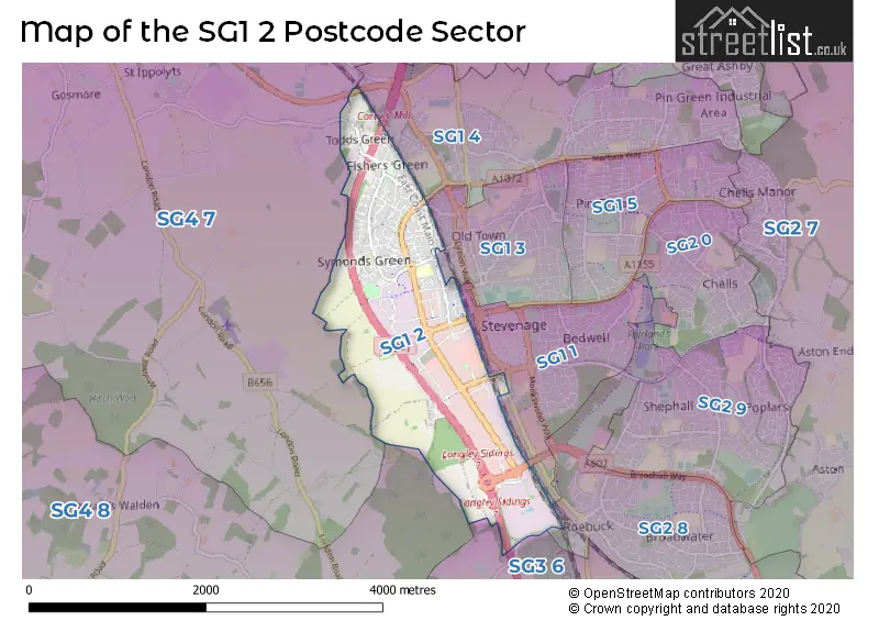
The SG1 2 Postcode shares a border with SG1 1 (STEVENAGE), SG1 3 (STEVENAGE), SG1 4 (STEVENAGE), SG2 8 (STEVENAGE), SG3 6 (KNEBWORTH, Woolmer Green, Datchworth), SG4 7 (Weston, St. Ippolyts, Little Wymondley) and SG4 8 (Codicote, Kimpton, Whitwell).
Map of the SG1 2 Postcode Sector
Explore the SG1 2 postcode sector by using our interactive map.
The sector is within the post town of STEVENAGE.
SG1 2 is a postcode sector within the SG1 postcode district which is within the SG Stevenage postcode area.
The Royal Mail delivery office for the SG1 2 postal sector is the Stevenage Delivery Office.
The area of the SG1 2 postcode sector is 2.20 square miles which is 5.69 square kilometres or 1,407.16 square acres.
The SG1 2 postcode sector is crossed by the A1M Major A road.
Your support helps keep this site running!
If you enjoy using this website, consider buying me a coffee to help cover hosting costs.

| S | G | 1 | - | 2 | X | X |
| S | G | 1 | Space | 2 | Letter | Letter |
Official List of Streets
STEVENAGE (81 Streets)
Unofficial Streets or Alternative Spellings
STEVENAGE
BRIDGE ROAD BROADHALL WAY FAIRLANDS WAY KINGS ROAD OLD KNEBWORTH LANE APPLETON COURT ASPECT ONE BRIDGE ROAD CLOVELLY WAY GUNNELS WOOD PARK JULIANS ROAD LANGLEY SIDINGS LEYDON ROAD OLD CHANTRY LANE OLD GREAT NORTH ROAD (OLD A1) REDCAR ROAD SIX HILLS ROUNDABOUT SOMERTON COURTSt. Ippolyts
STEVENAGE ROADWeather Forecast for SG1 2
Weather Forecast for Stevenage
| Time Period | Icon | Description | Temperature | Rain Probability | Wind |
|---|---|---|---|---|---|
| 18:00 to 21:00 | Cloudy | 5.0°C (feels like 3.0°C) | 8.00% | SSE 7 mph | |
| 21:00 to 00:00 | Partly cloudy (night) | 4.0°C (feels like 0.0°C) | 1.00% | SSE 9 mph |
| Time Period | Icon | Description | Temperature | Rain Probability | Wind |
|---|---|---|---|---|---|
| 00:00 to 03:00 | Partly cloudy (night) | 2.0°C (feels like -1.0°C) | 3.00% | SSE 7 mph | |
| 03:00 to 06:00 | Partly cloudy (night) | 2.0°C (feels like -2.0°C) | 1.00% | SSE 7 mph | |
| 06:00 to 09:00 | Clear night | 1.0°C (feels like -3.0°C) | 0.00% | SE 7 mph | |
| 09:00 to 12:00 | Sunny day | 1.0°C (feels like -2.0°C) | 0.00% | SSE 7 mph | |
| 12:00 to 15:00 | Sunny day | 5.0°C (feels like 2.0°C) | 0.00% | S 7 mph | |
| 15:00 to 18:00 | Sunny day | 6.0°C (feels like 3.0°C) | 0.00% | S 7 mph | |
| 18:00 to 21:00 | Clear night | 3.0°C (feels like 1.0°C) | 0.00% | SSW 4 mph | |
| 21:00 to 00:00 | Clear night | 2.0°C (feels like -1.0°C) | 1.00% | S 4 mph |
| Time Period | Icon | Description | Temperature | Rain Probability | Wind |
|---|---|---|---|---|---|
| 00:00 to 03:00 | Clear night | 1.0°C (feels like -2.0°C) | 1.00% | SSW 4 mph | |
| 03:00 to 06:00 | Cloudy | 1.0°C (feels like -2.0°C) | 8.00% | SSW 7 mph | |
| 06:00 to 09:00 | Overcast | 1.0°C (feels like -2.0°C) | 11.00% | SSW 7 mph | |
| 09:00 to 12:00 | Overcast | 3.0°C (feels like 0.0°C) | 9.00% | SSW 7 mph | |
| 12:00 to 15:00 | Cloudy | 6.0°C (feels like 3.0°C) | 5.00% | SSW 9 mph | |
| 15:00 to 18:00 | Partly cloudy (day) | 7.0°C (feels like 4.0°C) | 3.00% | SSW 9 mph | |
| 18:00 to 21:00 | Partly cloudy (night) | 5.0°C (feels like 2.0°C) | 2.00% | S 9 mph | |
| 21:00 to 00:00 | Cloudy | 4.0°C (feels like 1.0°C) | 5.00% | SSW 9 mph |
| Time Period | Icon | Description | Temperature | Rain Probability | Wind |
|---|---|---|---|---|---|
| 00:00 to 03:00 | Cloudy | 4.0°C (feels like 1.0°C) | 6.00% | SSW 9 mph | |
| 03:00 to 06:00 | Partly cloudy (night) | 4.0°C (feels like 0.0°C) | 4.00% | S 11 mph | |
| 06:00 to 09:00 | Partly cloudy (night) | 4.0°C (feels like 0.0°C) | 3.00% | SSW 11 mph | |
| 09:00 to 12:00 | Overcast | 5.0°C (feels like 2.0°C) | 9.00% | SSW 11 mph | |
| 12:00 to 15:00 | Cloudy | 8.0°C (feels like 5.0°C) | 6.00% | SSW 13 mph | |
| 15:00 to 18:00 | Overcast | 9.0°C (feels like 6.0°C) | 14.00% | SSW 13 mph | |
| 18:00 to 21:00 | Light rain | 8.0°C (feels like 5.0°C) | 45.00% | SSW 11 mph | |
| 21:00 to 00:00 | Cloudy | 8.0°C (feels like 5.0°C) | 13.00% | SW 9 mph |
| Time Period | Icon | Description | Temperature | Rain Probability | Wind |
|---|---|---|---|---|---|
| 00:00 to 03:00 | Clear night | 6.0°C (feels like 3.0°C) | 5.00% | WSW 9 mph | |
| 03:00 to 06:00 | Clear night | 4.0°C (feels like 2.0°C) | 4.00% | W 7 mph | |
| 06:00 to 09:00 | Clear night | 3.0°C (feels like 0.0°C) | 2.00% | WNW 7 mph | |
| 09:00 to 12:00 | Partly cloudy (day) | 3.0°C (feels like 1.0°C) | 2.00% | WNW 4 mph | |
| 12:00 to 15:00 | Cloudy | 7.0°C (feels like 5.0°C) | 4.00% | NW 7 mph | |
| 15:00 to 18:00 | Cloudy | 7.0°C (feels like 6.0°C) | 4.00% | NNW 7 mph | |
| 18:00 to 21:00 | Cloudy | 4.0°C (feels like 2.0°C) | 4.00% | N 4 mph | |
| 21:00 to 00:00 | Partly cloudy (night) | 3.0°C (feels like 1.0°C) | 1.00% | NNE 4 mph |
Schools and Places of Education Within the SG1 2 Postcode Sector
Woolenwick Infant and Nursery School
Community school
Bridge Road West, Stevenage, Hertfordshire, SG1 2NU
Head: Ms Usha Dhorajiwala
Ofsted Rating: Outstanding
Inspection: 2023-09-14 (506 days ago)
Website: Visit Woolenwick Infant and Nursery School Website
Phone: 01438216070
Number of Pupils: 211
Woolenwick Junior School
Community school
Bridge Road West, Stevenage, Hertfordshire, SG1 2NU
Head: Mr Richard Pallant
Ofsted Rating: Good
Inspection: 2023-12-14 (415 days ago)
Website: Visit Woolenwick Junior School Website
Phone: 01438216565
Number of Pupils: 232
House Prices in the SG1 2 Postcode Sector
| Type of Property | 2018 Average | 2018 Sales | 2017 Average | 2017 Sales | 2016 Average | 2016 Sales | 2015 Average | 2015 Sales |
|---|---|---|---|---|---|---|---|---|
| Detached | £725,833 | 3 | £505,908 | 22 | £494,958 | 24 | £436,500 | 13 |
| Semi-Detached | £384,000 | 20 | £371,252 | 22 | £346,837 | 14 | £316,794 | 17 |
| Terraced | £290,298 | 36 | £303,670 | 32 | £270,653 | 46 | £240,949 | 46 |
| Flats | £162,187 | 36 | £167,838 | 34 | £161,176 | 41 | £130,954 | 44 |
Important Postcodes SG1 2 in the Postcode Sector
SG1 2AD is the postcode for North Herts Probation Centre, Argyle House, Argyle Way
SG1 2AF is the postcode for 1-5 FULTON CLOSE, STEVENAGE, 6 FULTON CLOSE, STEVENAGE, Unit 1-5, Fulton Road, 6 Fulton Close, 1-5 Fulton Close, Unit 6, Fulton Close, and Units 1-4, Fulton Close
SG1 2BP is the postcode for Leyden House Day Centre, Leyden Road
SG1 2FQ is the postcode for Farnham House, Six Hills Way, and Robertson House, Six Hills Way
SG1 2NU is the postcode for Woolenwick Junior School, Bridge Road West, and Woolenwick Infant & Nursery School, Bridge Road West
SG1 2ST is the postcode for Job Centre, Abel Smith House, Gunnels Wood Road
SG1 2UA is the postcode for Kingsway Health Centre, Unit 18 Stevenage Leisure Park
| The SG1 2 Sector is within these Local Authorities |
|
|---|---|
| The SG1 2 Sector is within these Counties |
|
| The SG1 2 Sector is within these Water Company Areas |
|