A wide range of spatial data has been analysed to present this overview of the SE27 9 Postcode sector. If you would like anything added, please contact us.
The SE27 9 postcode sector is within the county of Greater London.
Did you know? According to the 2021 Census, the SE27 9 postcode sector is home to a bustling 9,896 residents!
Given that each sector allows for 400 unique postcode combinations. Letters C, I, K, M, O and V are not allowed in the last two letters of a postcode. With 172 postcodes already in use, this leaves 228 units available.
The SE27 9 postal code covers the settlement of LONDON .
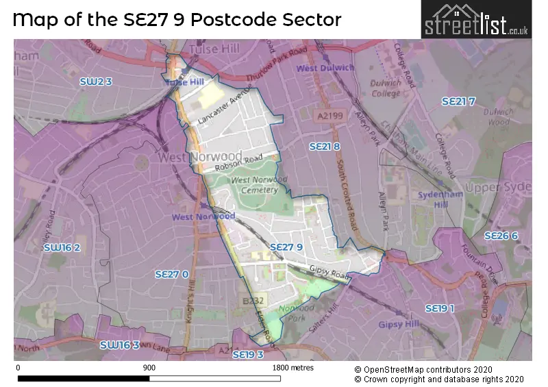
The SE27 9 Postcode shares a border with SE19 1 (LONDON , UPPER NORWOOD ), SE21 8 (LONDON ), SE24 9 (LONDON ), SE27 0 (LONDON ), SW2 3 (LONDON ) and SE19 3 (UPPER NORWOOD , LONDON ).
Map of the SE27 9 Postcode Sector
Explore the SE27 9 postcode sector by using our interactive map.
The sector is within the post town of LONDON.
SE27 9 is a postcode sector within the SE27 postcode district which is within the SE South Eastern London postcode area.
The Royal Mail delivery office for the SE27 9 postal sector is the West Norwood Sdelivery Office.
The area of the SE27 9 postcode sector is 0.44 square miles which is 1.13 square kilometres or 280.45 square acres.
Your support helps keep this site running!
If you enjoy using this website, consider buying me a coffee to help cover hosting costs.


| S | E | 2 | 7 | - | 9 | X | X |
| S | E | 2 | 7 | Space | 9 | Letter | Letter |
Official List of Streets
Lambeth (69 Streets)
Unofficial Streets or Alternative Spellings
Lambeth
BERRY LANE CANTERBURY GROVE CHANCELLOR GROVE CHAPEL ROAD CHRISTCHURCH ROAD COTSWOLD STREET EASTMEARN ROAD ELDERBERRY GROVE ERNEST AVENUE GIPSY HILL HANNEN ROAD HARPENDEN ROAD LANGMEAD STREET LANSDOWNE HILL LINTON GROVE PERRAN ROAD ROTHSCHILD STREET SOUTH CROXTED ROAD TULSE HILL ULLSWATER ROADSouthwark
ALLEYN PARK ALLEYN ROAD BEETON PATH CHURCH ROAD DOULTON PATH HOBBS ROAD LOWER ROAD MALEY AVE NARROW ROAD SALTERS HILL SHIP PATH ST BENARDS CLOSE ST-MARY-AT-HILL PATHWeather Forecast for SE27 9
Weather Forecast for Crystal Palace National Sports Centre
| Time Period | Icon | Description | Temperature | Rain Probability | Wind |
|---|---|---|---|---|---|
| 03:00 to 06:00 | Cloudy | 1.0°C (feels like -1.0°C) | 8.00% | ENE 4 mph | |
| 06:00 to 09:00 | Cloudy | 1.0°C (feels like -1.0°C) | 11.00% | ENE 4 mph | |
| 09:00 to 12:00 | Cloudy | 2.0°C (feels like 0.0°C) | 12.00% | ENE 4 mph | |
| 12:00 to 15:00 | Overcast | 3.0°C (feels like 2.0°C) | 14.00% | ENE 4 mph | |
| 15:00 to 18:00 | Cloudy | 5.0°C (feels like 3.0°C) | 13.00% | ENE 4 mph | |
| 18:00 to 21:00 | Cloudy | 4.0°C (feels like 2.0°C) | 16.00% | NE 4 mph | |
| 21:00 to 00:00 | Light rain | 4.0°C (feels like 2.0°C) | 45.00% | NE 4 mph |
| Time Period | Icon | Description | Temperature | Rain Probability | Wind |
|---|---|---|---|---|---|
| 00:00 to 03:00 | Light rain | 4.0°C (feels like 2.0°C) | 47.00% | NE 4 mph | |
| 03:00 to 06:00 | Overcast | 4.0°C (feels like 1.0°C) | 24.00% | WNW 4 mph | |
| 06:00 to 09:00 | Overcast | 4.0°C (feels like 1.0°C) | 22.00% | WSW 7 mph | |
| 09:00 to 12:00 | Overcast | 3.0°C (feels like 1.0°C) | 20.00% | WSW 7 mph | |
| 12:00 to 15:00 | Overcast | 5.0°C (feels like 2.0°C) | 16.00% | WSW 7 mph | |
| 15:00 to 18:00 | Overcast | 6.0°C (feels like 4.0°C) | 17.00% | WSW 7 mph | |
| 18:00 to 21:00 | Overcast | 5.0°C (feels like 3.0°C) | 16.00% | SW 7 mph | |
| 21:00 to 00:00 | Overcast | 5.0°C (feels like 3.0°C) | 15.00% | SW 7 mph |
Schools and Places of Education Within the SE27 9 Postcode Sector
Elm Wood School
Community school
Carnac Street, London, , SE27 9RR
Head: Mrs Jo Leith
Ofsted Rating: Good
Inspection: 2019-10-10 (1931 days ago)
Website: Visit Elm Wood School Website
Phone: 02086701621
Number of Pupils: 390
Kingswood Primary School
Community school
Gipsy Road, London, , SE27 9RD
Head: Ms Kelly Foster
Ofsted Rating: Good
Inspection: 2019-03-14 (2141 days ago)
Website: Visit Kingswood Primary School Website
Phone: 02086703576
Number of Pupils: 519
The Elmgreen School
Academy converter
Elmcourt Road, London, , SE27 9BZ
Head: Mr Dominic Bergin
Ofsted Rating: Good
Inspection: 2022-06-30 (937 days ago)
Website: Visit The Elmgreen School Website
Phone: 02087665020
Number of Pupils: 1113

House Prices in the SE27 9 Postcode Sector
| Type of Property | 2018 Average | 2018 Sales | 2017 Average | 2017 Sales | 2016 Average | 2016 Sales | 2015 Average | 2015 Sales |
|---|---|---|---|---|---|---|---|---|
| Detached | £1,182,575 | 2 | £0 | 0 | £1,887,500 | 2 | £1,265,000 | 4 |
| Semi-Detached | £544,000 | 8 | £847,850 | 10 | £777,050 | 10 | £615,562 | 13 |
| Terraced | £672,931 | 40 | £671,772 | 34 | £695,961 | 38 | £601,029 | 45 |
| Flats | £357,758 | 82 | £366,548 | 85 | £397,789 | 94 | £326,509 | 116 |
Important Postcodes SE27 9 in the Postcode Sector
SE27 9AW is the postcode for Inner London Probation Service, 248-250 Norwood Road, and Elmcourt Health Centre, 214 Norwood Road
SE27 9BZ is the postcode for The Elmgreen School, Elmcourt Road
SE27 9DG is the postcode for 445 Norwood Road
SE27 9JU is the postcode for South Metropolitan Cemetery, Norwood High Street
SE27 9JX is the postcode for Nettleford Hall & West Norwood Library, 1-5 Norwood High Street
SE27 9NP is the postcode for Evolve Academy West Norwood, Gipsy Road, Park Campus, Gipsy Road, Kingswood Primary School, 55 Gipsy Road, and Kingwood Primary School Lower Site, 55 Gipsy Road
SE27 9NR is the postcode for South East Community Mental Health Team, 24-28 Norwood High Street
SE27 9RD is the postcode for Kingswood Primary School, Gipsy Road
SE27 9RR is the postcode for Elm Wood Primary School, Carnac Street
SE27 9UD is the postcode for 18, Benton's Lane
| The SE27 9 Sector is within these Local Authorities |
|
|---|---|
| The SE27 9 Sector is within these Counties |
|
| The SE27 9 Sector is within these Water Company Areas |
|