A wide range of spatial data has been analysed to present this overview of the SE25 5 Postcode sector. If you would like anything added, please contact us.
The SE25 5 postcode sector is within the county of Greater London.
Did you know? According to the 2021 Census, the SE25 5 postcode sector is home to a bustling 9,726 residents!
Given that each sector allows for 400 unique postcode combinations. Letters C, I, K, M, O and V are not allowed in the last two letters of a postcode. With 160 postcodes already in use, this leaves 240 units available.
The SE25 5 postal code covers the settlement of SOUTH NORWOOD .
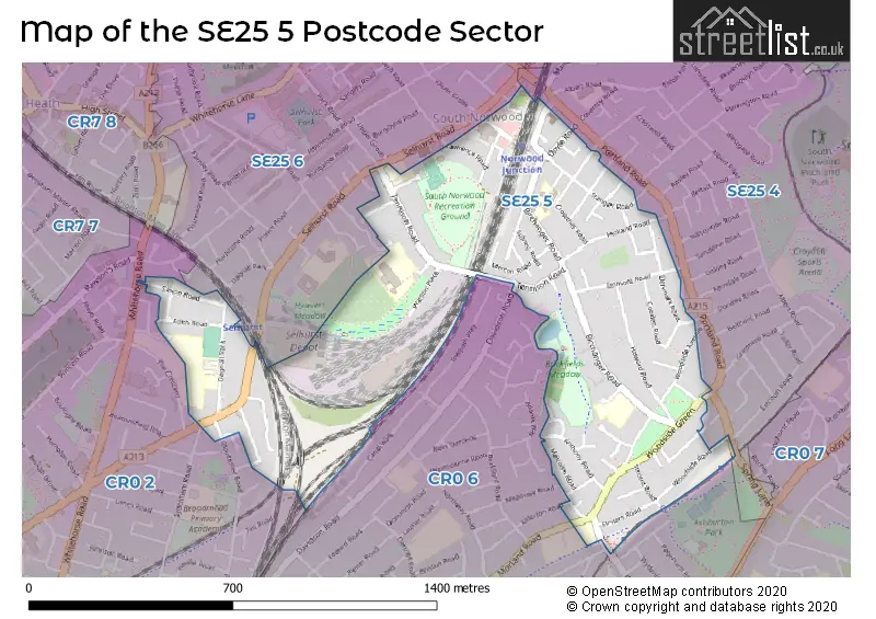
The SE25 5 Postcode shares a border with SE25 6 (SOUTH NORWOOD ), CR0 6 (CROYDON ), SE25 4 (SOUTH NORWOOD ) and CR0 2 (CROYDON ).
Map of the SE25 5 Postcode Sector
Explore the SE25 5 postcode sector by using our interactive map.
The sector is within the post town of LONDON.
SE25 5 is a postcode sector within the SE25 postcode district which is within the SE South Eastern London postcode area.
The Royal Mail delivery office for the SE25 5 postal sector is the South Norwood Sdelivery Office.
The area of the SE25 5 postcode sector is 0.52 square miles which is 1.34 square kilometres or 332.09 square acres.
Your support helps keep this site running!
If you enjoy using this website, consider buying me a coffee to help cover hosting costs.

| S | E | 2 | 5 | - | 5 | X | X |
| S | E | 2 | 5 | Space | 5 | Letter | Letter |
Official List of Streets
Croydon (63 Streets)
(2 Streets)
Unofficial Streets or Alternative Spellings
Weather Forecast for SE25 5
Weather Forecast for Robert Fitzroy Academy
| Time Period | Icon | Description | Temperature | Rain Probability | Wind |
|---|---|---|---|---|---|
| 09:00 to 12:00 | Sunny day | 3.0°C (feels like 1.0°C) | 0.00% | SE 4 mph | |
| 12:00 to 15:00 | Sunny day | 6.0°C (feels like 4.0°C) | 0.00% | S 4 mph | |
| 15:00 to 18:00 | Sunny day | 6.0°C (feels like 5.0°C) | 0.00% | SSE 4 mph | |
| 18:00 to 21:00 | Clear night | 4.0°C (feels like 3.0°C) | 0.00% | S 4 mph | |
| 21:00 to 00:00 | Clear night | 2.0°C (feels like 1.0°C) | 1.00% | SSW 4 mph |
| Time Period | Icon | Description | Temperature | Rain Probability | Wind |
|---|---|---|---|---|---|
| 00:00 to 03:00 | Clear night | 1.0°C (feels like 0.0°C) | 2.00% | SSW 4 mph | |
| 03:00 to 06:00 | Cloudy | 1.0°C (feels like -1.0°C) | 5.00% | SSW 4 mph | |
| 06:00 to 09:00 | Cloudy | 1.0°C (feels like -1.0°C) | 6.00% | SW 4 mph | |
| 09:00 to 12:00 | Overcast | 3.0°C (feels like 1.0°C) | 9.00% | SSW 4 mph | |
| 12:00 to 15:00 | Cloudy | 6.0°C (feels like 4.0°C) | 6.00% | SSW 4 mph | |
| 15:00 to 18:00 | Partly cloudy (day) | 7.0°C (feels like 6.0°C) | 2.00% | SSW 7 mph | |
| 18:00 to 21:00 | Clear night | 5.0°C (feels like 3.0°C) | 2.00% | SSW 7 mph | |
| 21:00 to 00:00 | Partly cloudy (night) | 4.0°C (feels like 2.0°C) | 2.00% | SSW 7 mph |
| Time Period | Icon | Description | Temperature | Rain Probability | Wind |
|---|---|---|---|---|---|
| 00:00 to 03:00 | Cloudy | 4.0°C (feels like 1.0°C) | 5.00% | SSW 7 mph | |
| 03:00 to 06:00 | Clear night | 5.0°C (feels like 2.0°C) | 2.00% | S 7 mph | |
| 06:00 to 09:00 | Partly cloudy (night) | 5.0°C (feels like 2.0°C) | 3.00% | SSW 7 mph | |
| 09:00 to 12:00 | Partly cloudy (day) | 6.0°C (feels like 3.0°C) | 2.00% | SSW 9 mph | |
| 12:00 to 15:00 | Overcast | 9.0°C (feels like 6.0°C) | 8.00% | SSW 9 mph | |
| 15:00 to 18:00 | Cloudy | 10.0°C (feels like 7.0°C) | 10.00% | SSW 9 mph | |
| 18:00 to 21:00 | Overcast | 8.0°C (feels like 6.0°C) | 19.00% | SSW 9 mph | |
| 21:00 to 00:00 | Cloudy | 8.0°C (feels like 6.0°C) | 17.00% | SW 9 mph |
| Time Period | Icon | Description | Temperature | Rain Probability | Wind |
|---|---|---|---|---|---|
| 00:00 to 03:00 | Clear night | 7.0°C (feels like 5.0°C) | 8.00% | WSW 7 mph | |
| 03:00 to 06:00 | Clear night | 6.0°C (feels like 4.0°C) | 5.00% | W 4 mph | |
| 06:00 to 09:00 | Clear night | 4.0°C (feels like 2.0°C) | 2.00% | WNW 4 mph | |
| 09:00 to 12:00 | Partly cloudy (day) | 4.0°C (feels like 3.0°C) | 2.00% | WNW 4 mph | |
| 12:00 to 15:00 | Partly cloudy (day) | 7.0°C (feels like 6.0°C) | 1.00% | NW 4 mph | |
| 15:00 to 18:00 | Cloudy | 8.0°C (feels like 7.0°C) | 5.00% | N 4 mph | |
| 18:00 to 21:00 | Cloudy | 6.0°C (feels like 5.0°C) | 5.00% | N 4 mph | |
| 21:00 to 00:00 | Cloudy | 5.0°C (feels like 3.0°C) | 5.00% | N 4 mph |
Schools and Places of Education Within the SE25 5 Postcode Sector
Aya College (Educational Provision)
Other independent school
Holly Lodge, London, , SE25 5PQ
Head: Mr Michael Buadi
Ofsted Rating: Requires improvement
Inspection: 2022-05-06 (1003 days ago)
Website: Visit Aya College (Educational Provision) Website
Phone: 02085445102
Number of Pupils: 0
Crosfield Nursery School
Local authority nursery school
Elborough Road, London, , SE25 5BD
Head: Mr Daniel Bissex
Ofsted Rating: Good
Inspection: 2018-12-18 (2238 days ago)
Website: Visit Crosfield Nursery School Website
Phone: 02086547566
Number of Pupils: 50
Selhurst Nursery School and Children's Centre
Local authority nursery school
23 Dagnall Park, London, , SE25 5PL
Head: Mr Daniel Bissex
Ofsted Rating: Good
Inspection: 2024-01-25 (374 days ago)
Website: Visit Selhurst Nursery School and Children's Centre Website
Phone: 02086843777
Number of Pupils: 50
South Norwood Primary
Academy sponsor led
34 Crowther Road, London, , SE25 5QP
Head: Mrs Melody Berthoud
Ofsted Rating: Good
Inspection: 2023-01-11 (753 days ago)
Website: Visit South Norwood Primary Website
Phone: 02086542983
Number of Pupils: 331
St Thomas Becket Catholic Primary School
Academy converter
Becket Close, London, , SE25 5BN
Head: Mr Diarmuid Skehan
Ofsted Rating: Good
Inspection: 2022-03-16 (1054 days ago)
Website: Visit St Thomas Becket Catholic Primary School Website
Phone: 02086543006
Number of Pupils: 411
House Prices in the SE25 5 Postcode Sector
| Type of Property | 2018 Average | 2018 Sales | 2017 Average | 2017 Sales | 2016 Average | 2016 Sales | 2015 Average | 2015 Sales |
|---|---|---|---|---|---|---|---|---|
| Detached | £767,500 | 4 | £1,005,000 | 2 | £602,500 | 2 | £386,000 | 2 |
| Semi-Detached | £421,470 | 12 | £457,500 | 17 | £455,536 | 7 | £348,953 | 16 |
| Terraced | £380,876 | 53 | £368,177 | 51 | £363,646 | 60 | £320,607 | 58 |
| Flats | £267,848 | 69 | £266,678 | 128 | £244,314 | 93 | £199,161 | 88 |
Important Postcodes SE25 5 in the Postcode Sector
SE25 5BN is the postcode for St. Thomas Becket RC Primary, Birchanger Road
SE25 5NS is the postcode for Woodside Health Centre, 3 Enmore Road
SE25 5NT is the postcode for Woodside Health Centre, 3 Enmore Road
SE25 5QP is the postcode for JUNIOR BLOCK, South Norwood Primary School, 34 Crowther Road, South Norwood Primary School, 34 Crowther Road, and INFANT BLOCK, South Norwood Primary School, 34 Crowther Road
SE25 5RR is the postcode for Beckmead College, Tennison Road, South Norwood, and Priory School, Tennison Road
| The SE25 5 Sector is within these Local Authorities |
|
|---|---|
| The SE25 5 Sector is within these Counties |
|
| The SE25 5 Sector is within these Water Company Areas |
|