A wide range of spatial data has been analysed to present this overview of the SE15 4 Postcode sector. If you would like anything added, please contact us.
The SE15 4 postcode sector is within the county of Greater London.
Did you know? According to the 2021 Census, the SE15 4 postcode sector is home to a bustling 8,398 residents!
Given that each sector allows for 400 unique postcode combinations. Letters C, I, K, M, O and V are not allowed in the last two letters of a postcode. With 155 postcodes already in use, this leaves 245 units available.
The SE15 4 postal code covers the settlement of LONDON .
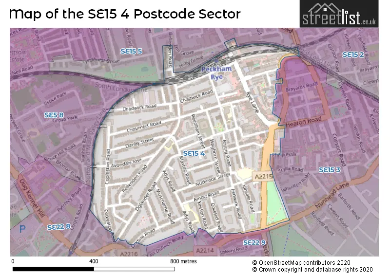
The SE15 4 Postcode shares a border with SE5 8 (LONDON ), SE15 2 (LONDON ), SE15 3 (LONDON ), SE15 5 (LONDON ), SE22 8 (LONDON ) and SE22 9 (LONDON ).
Map of the SE15 4 Postcode Sector
Explore the SE15 4 postcode sector by using our interactive map.
The sector is within the post town of LONDON.
SE15 4 is a postcode sector within the SE15 postcode district which is within the SE South Eastern London postcode area.
The Royal Mail delivery office for the SE15 4 postal sector is the Peckham Sdelivery Office.
The area of the SE15 4 postcode sector is 0.29 square miles which is 0.75 square kilometres or 184.57 square acres.
Your support helps keep this site running!
If you enjoy using this website, consider buying me a coffee to help cover hosting costs.


| S | E | 1 | 5 | - | 4 | X | X |
| S | E | 1 | 5 | Space | 4 | Letter | Letter |
Official List of Streets
Southwark (55 Streets)
Unofficial Streets or Alternative Spellings
Weather Forecast for SE15 4
Weather Forecast for Millwall F.C.
| Time Period | Icon | Description | Temperature | Rain Probability | Wind |
|---|---|---|---|---|---|
| 21:00 to 00:00 | Clear night | 4.0°C (feels like 1.0°C) | 0.00% | SE 7 mph |
| Time Period | Icon | Description | Temperature | Rain Probability | Wind |
|---|---|---|---|---|---|
| 00:00 to 03:00 | Clear night | 3.0°C (feels like 2.0°C) | 0.00% | SE 4 mph | |
| 03:00 to 06:00 | Clear night | 3.0°C (feels like 1.0°C) | 0.00% | SE 4 mph | |
| 06:00 to 09:00 | Clear night | 2.0°C (feels like 0.0°C) | 0.00% | ESE 4 mph | |
| 09:00 to 12:00 | Sunny day | 2.0°C (feels like 1.0°C) | 0.00% | ESE 4 mph | |
| 12:00 to 15:00 | Sunny day | 6.0°C (feels like 4.0°C) | 0.00% | SE 4 mph | |
| 15:00 to 18:00 | Sunny day | 7.0°C (feels like 6.0°C) | 0.00% | SSE 4 mph | |
| 18:00 to 21:00 | Clear night | 5.0°C (feels like 4.0°C) | 0.00% | S 4 mph | |
| 21:00 to 00:00 | Clear night | 3.0°C (feels like 2.0°C) | 1.00% | SSW 2 mph |
| Time Period | Icon | Description | Temperature | Rain Probability | Wind |
|---|---|---|---|---|---|
| 00:00 to 03:00 | Clear night | 2.0°C (feels like 0.0°C) | 1.00% | S 4 mph | |
| 03:00 to 06:00 | Partly cloudy (night) | 1.0°C (feels like -1.0°C) | 2.00% | SSW 2 mph | |
| 06:00 to 09:00 | Cloudy | 1.0°C (feels like -1.0°C) | 6.00% | SSW 2 mph | |
| 09:00 to 12:00 | Overcast | 3.0°C (feels like 1.0°C) | 9.00% | SSW 4 mph | |
| 12:00 to 15:00 | Cloudy | 6.0°C (feels like 5.0°C) | 6.00% | SSW 4 mph | |
| 15:00 to 18:00 | Partly cloudy (day) | 8.0°C (feels like 6.0°C) | 2.00% | SSW 7 mph | |
| 18:00 to 21:00 | Partly cloudy (night) | 6.0°C (feels like 4.0°C) | 2.00% | SSW 7 mph | |
| 21:00 to 00:00 | Partly cloudy (night) | 5.0°C (feels like 2.0°C) | 2.00% | SSW 7 mph |
| Time Period | Icon | Description | Temperature | Rain Probability | Wind |
|---|---|---|---|---|---|
| 00:00 to 03:00 | Cloudy | 4.0°C (feels like 2.0°C) | 5.00% | SSW 7 mph | |
| 03:00 to 06:00 | Clear night | 5.0°C (feels like 2.0°C) | 3.00% | SSW 7 mph | |
| 06:00 to 09:00 | Partly cloudy (night) | 5.0°C (feels like 2.0°C) | 3.00% | SSW 7 mph | |
| 09:00 to 12:00 | Partly cloudy (day) | 6.0°C (feels like 3.0°C) | 2.00% | SSW 9 mph | |
| 12:00 to 15:00 | Overcast | 9.0°C (feels like 6.0°C) | 8.00% | SSW 11 mph | |
| 15:00 to 18:00 | Cloudy | 10.0°C (feels like 7.0°C) | 10.00% | SSW 11 mph | |
| 18:00 to 21:00 | Overcast | 9.0°C (feels like 7.0°C) | 19.00% | SSW 9 mph | |
| 21:00 to 00:00 | Cloudy | 9.0°C (feels like 7.0°C) | 17.00% | SW 9 mph |
| Time Period | Icon | Description | Temperature | Rain Probability | Wind |
|---|---|---|---|---|---|
| 00:00 to 03:00 | Clear night | 7.0°C (feels like 5.0°C) | 8.00% | WSW 7 mph | |
| 03:00 to 06:00 | Clear night | 6.0°C (feels like 4.0°C) | 5.00% | W 4 mph | |
| 06:00 to 09:00 | Clear night | 4.0°C (feels like 2.0°C) | 2.00% | WNW 4 mph | |
| 09:00 to 12:00 | Partly cloudy (day) | 4.0°C (feels like 3.0°C) | 2.00% | WNW 4 mph | |
| 12:00 to 15:00 | Partly cloudy (day) | 7.0°C (feels like 6.0°C) | 1.00% | NW 4 mph | |
| 15:00 to 18:00 | Cloudy | 8.0°C (feels like 7.0°C) | 5.00% | N 4 mph | |
| 18:00 to 21:00 | Cloudy | 7.0°C (feels like 6.0°C) | 5.00% | N 4 mph | |
| 21:00 to 00:00 | Cloudy | 5.0°C (feels like 4.0°C) | 5.00% | N 4 mph |
Schools and Places of Education Within the SE15 4 Postcode Sector
Bellenden Primary School
Community school
Dewar Street, London, , SE15 4JP
Head: Mr Gregory Doey
Ofsted Rating: Good
Inspection: 2018-09-18 (2328 days ago)
Website: Visit Bellenden Primary School Website
Phone: 02077327107
Number of Pupils: 218
St John's and St Clement's Church of England Primary School
Voluntary aided school
Adys Road, London, , SE15 4DY
Head: Mr Joseph Bell and Miss Alli Crank
Ofsted Rating: Good
Inspection: 2023-06-15 (597 days ago)
Website: Visit St John's and St Clement's Church of England Primary School Website
Phone: 02075259210
Number of Pupils: 358
The Belham Primary School
Free schools
165 Bellenden Road, London, , SE15 4DG
Head: Ms Alison Sprakes
Ofsted Rating: Good
Inspection: 2018-07-18 (2390 days ago)
Website: Visit The Belham Primary School Website
Phone: 02083534290
Number of Pupils: 401
House Prices in the SE15 4 Postcode Sector
| Type of Property | 2018 Average | 2018 Sales | 2017 Average | 2017 Sales | 2016 Average | 2016 Sales | 2015 Average | 2015 Sales |
|---|---|---|---|---|---|---|---|---|
| Detached | £2,400,000 | 1 | £0 | 0 | £1,150,000 | 1 | £1,208,025 | 2 |
| Semi-Detached | £1,053,625 | 12 | £996,389 | 9 | £941,050 | 5 | £1,006,159 | 11 |
| Terraced | £936,092 | 46 | £820,745 | 38 | £773,009 | 45 | £779,774 | 47 |
| Flats | £475,042 | 56 | £468,957 | 62 | £487,259 | 75 | £434,941 | 68 |
Important Postcodes SE15 4 in the Postcode Sector
SE15 4DG is the postcode for THE BELHAM PRIMARY SCHOOL, BELLENDEN ROAD, and Belham Primary School, 165 Bellenden Road
SE15 4DY is the postcode for St Johns And St Clements Primary School, Adys Road
SE15 4NX is the postcode for Thomas Calton Community Education Centre, Alpha Street, and MAIN BUILDING, Adult Learning Service, Thomas Calton Centre
SE15 4PF is the postcode for Bellenden Junior & Infant School, Reedham Street
SE15 4PU is the postcode for DMC Chadwick Road, 60 Chadwick Road
SE15 4UJ is the postcode for 17-23, London Borough of Southwark, 17-27 Bournemouth Road
| The SE15 4 Sector is within these Local Authorities |
|
|---|---|
| The SE15 4 Sector is within these Counties |
|
| The SE15 4 Sector is within these Water Company Areas |
|