A wide range of spatial data has been analysed to present this overview of the SE10 8 Postcode sector. If you would like anything added, please contact us.
The SE10 8 postcode sector is within the county of Greater London.
Did you know? According to the 2021 Census, the SE10 8 postcode sector is home to a bustling 9,690 residents!
Given that each sector allows for 400 unique postcode combinations. Letters C, I, K, M, O and V are not allowed in the last two letters of a postcode. With 213 postcodes already in use, this leaves 187 units available.
The largest settlements in the SE10 8 postal code are GREENWICH and LONDON .
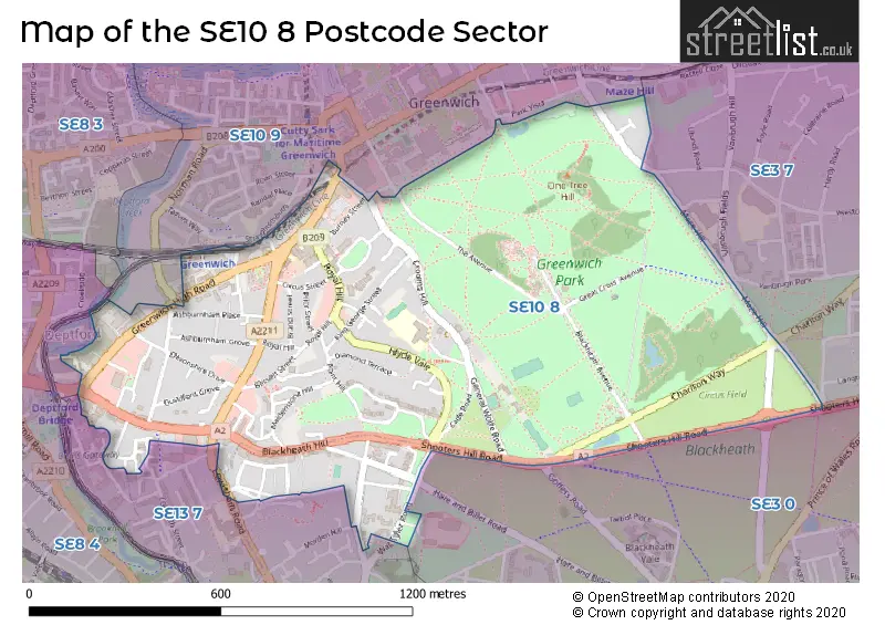
The SE10 8 Postcode shares a border with SE3 0 (BLACKHEATH , KIDBROOKE , LONDON ), SE3 7 (BLACKHEATH , CHARLTON ), SE8 4 (LONDON ), SE10 9 (GREENWICH , BLACKHEATH ) and SE13 7 (LADYWELL , LEWISHAM , GREENWICH ).
Map of the SE10 8 Postcode Sector
Explore the SE10 8 postcode sector by using our interactive map.
The sector is within the post town of LONDON.
SE10 8 is a postcode sector within the SE10 postcode district which is within the SE South Eastern London postcode area.
The Royal Mail delivery office for the SE10 8 postal sector is the Greenwich Sdelivery Office.
The area of the SE10 8 postcode sector is 0.69 square miles which is 1.79 square kilometres or 443.16 square acres.
Waterways within the SE10 8 postcode sector include the River Ravensbourne.
Your support helps keep this site running!
If you enjoy using this website, consider buying me a coffee to help cover hosting costs.


| S | E | 1 | 0 | - | 8 | X | X |
| S | E | 1 | 0 | Space | 8 | Letter | Letter |
Official List of Streets
Greenwich (59 Streets)
Lewisham (15 Streets)
Unofficial Streets or Alternative Spellings
Lewisham
DUKE HUMPHREY ROAD GOFFERS ROAD LEWISHAM HILL MORDEN HILL MORDEN LANEGreenwich
DEPTFORD BRIDGE FRANKLIN PLACE FRIENDLY PLACE HIGHMORE ROAD JOHN DONNE WAY LEWISHAM ROAD LOVIBOND LANE NEVADA STREET PRINCE OF ORANGE LANE ROAN STREET SHOOTERS HILL ROAD STRAIGHTSMOUTH VANBRUGH FIELDS VANBRUGH PARK VANBRUGH TERRACEWeather Forecast for SE10 8
Weather Forecast for Greenwich Park
| Time Period | Icon | Description | Temperature | Rain Probability | Wind |
|---|---|---|---|---|---|
| 21:00 to 00:00 | Cloudy | 7.0°C (feels like 4.0°C) | 5.00% | SSW 9 mph |
| Time Period | Icon | Description | Temperature | Rain Probability | Wind |
|---|---|---|---|---|---|
| 00:00 to 03:00 | Cloudy | 7.0°C (feels like 5.0°C) | 8.00% | SSW 9 mph | |
| 03:00 to 06:00 | Cloudy | 7.0°C (feels like 5.0°C) | 8.00% | SSW 9 mph | |
| 06:00 to 09:00 | Overcast | 7.0°C (feels like 4.0°C) | 8.00% | SSW 11 mph | |
| 09:00 to 12:00 | Cloudy | 8.0°C (feels like 5.0°C) | 5.00% | SSW 11 mph | |
| 12:00 to 15:00 | Cloudy | 9.0°C (feels like 6.0°C) | 4.00% | SSW 13 mph | |
| 15:00 to 18:00 | Cloudy | 10.0°C (feels like 7.0°C) | 6.00% | SSW 13 mph | |
| 18:00 to 21:00 | Overcast | 10.0°C (feels like 7.0°C) | 55.00% | SSW 13 mph | |
| 21:00 to 00:00 | Partly cloudy (night) | 9.0°C (feels like 7.0°C) | 19.00% | WSW 9 mph |
| Time Period | Icon | Description | Temperature | Rain Probability | Wind |
|---|---|---|---|---|---|
| 00:00 to 03:00 | Clear night | 7.0°C (feels like 5.0°C) | 3.00% | WSW 7 mph | |
| 03:00 to 06:00 | Clear night | 6.0°C (feels like 3.0°C) | 0.00% | WSW 7 mph | |
| 06:00 to 09:00 | Clear night | 5.0°C (feels like 2.0°C) | 0.00% | WSW 7 mph | |
| 09:00 to 12:00 | Cloudy | 5.0°C (feels like 2.0°C) | 4.00% | WSW 4 mph | |
| 12:00 to 15:00 | Cloudy | 7.0°C (feels like 6.0°C) | 4.00% | W 4 mph | |
| 15:00 to 18:00 | Cloudy | 8.0°C (feels like 7.0°C) | 5.00% | NW 4 mph | |
| 18:00 to 21:00 | Cloudy | 6.0°C (feels like 5.0°C) | 5.00% | NNW 4 mph | |
| 21:00 to 00:00 | Partly cloudy (night) | 5.0°C (feels like 4.0°C) | 1.00% | N 4 mph |
| Time Period | Icon | Description | Temperature | Rain Probability | Wind |
|---|---|---|---|---|---|
| 00:00 to 03:00 | Partly cloudy (night) | 4.0°C (feels like 2.0°C) | 1.00% | NNE 4 mph | |
| 03:00 to 06:00 | Clear night | 2.0°C (feels like 1.0°C) | 1.00% | NNE 4 mph | |
| 06:00 to 09:00 | Clear night | 1.0°C (feels like -1.0°C) | 0.00% | NE 4 mph | |
| 09:00 to 12:00 | Sunny day | 2.0°C (feels like 0.0°C) | 1.00% | NE 4 mph | |
| 12:00 to 15:00 | Sunny day | 6.0°C (feels like 4.0°C) | 2.00% | NE 7 mph | |
| 15:00 to 18:00 | Sunny day | 8.0°C (feels like 5.0°C) | 2.00% | ENE 9 mph | |
| 18:00 to 21:00 | Clear night | 5.0°C (feels like 3.0°C) | 2.00% | ENE 7 mph | |
| 21:00 to 00:00 | Clear night | 4.0°C (feels like 2.0°C) | 1.00% | NE 7 mph |
| Time Period | Icon | Description | Temperature | Rain Probability | Wind |
|---|---|---|---|---|---|
| 00:00 to 03:00 | Clear night | 3.0°C (feels like 1.0°C) | 2.00% | NE 7 mph | |
| 03:00 to 06:00 | Partly cloudy (night) | 3.0°C (feels like 0.0°C) | 2.00% | NE 7 mph | |
| 06:00 to 09:00 | Overcast | 3.0°C (feels like 0.0°C) | 7.00% | NE 7 mph | |
| 09:00 to 12:00 | Overcast | 4.0°C (feels like 0.0°C) | 9.00% | NE 9 mph | |
| 12:00 to 15:00 | Overcast | 5.0°C (feels like 2.0°C) | 8.00% | NE 9 mph | |
| 15:00 to 18:00 | Partly cloudy (day) | 6.0°C (feels like 3.0°C) | 3.00% | NE 9 mph | |
| 18:00 to 21:00 | Clear night | 5.0°C (feels like 2.0°C) | 2.00% | NE 7 mph | |
| 21:00 to 00:00 | Overcast | 3.0°C (feels like 1.0°C) | 8.00% | NE 7 mph |
Schools and Places of Education Within the SE10 8 Postcode Sector
James Wolfe Primary School and Centre for the Deaf
Community school
Royal Hill, London, , SE10 8RZ
Head: Mr Stephen Harris
Ofsted Rating: Good
Inspection: 2018-03-08 (2524 days ago)
Website: Visit James Wolfe Primary School and Centre for the Deaf Website
Phone: 02088582472
Number of Pupils: 780
St Ursula's Convent School
Voluntary aided school
Crooms Hill, London, , SE10 8HN
Head: Ms Ursula Norbert
Ofsted Rating: Outstanding
Inspection: 2015-03-12 (3616 days ago)
Website: Visit St Ursula's Convent School Website
Phone: 02088584613
Number of Pupils: 631
House Prices in the SE10 8 Postcode Sector
| Type of Property | 2018 Average | 2018 Sales | 2017 Average | 2017 Sales | 2016 Average | 2016 Sales | 2015 Average | 2015 Sales |
|---|---|---|---|---|---|---|---|---|
| Detached | £1,347,750 | 8 | £2,935,000 | 1 | £2,475,000 | 4 | £1,460,000 | 5 |
| Semi-Detached | £585,733 | 6 | £1,517,222 | 9 | £1,419,214 | 7 | £885,000 | 9 |
| Terraced | £953,236 | 39 | £969,630 | 45 | £920,012 | 38 | £983,956 | 63 |
| Flats | £404,405 | 186 | £419,449 | 140 | £466,787 | 99 | £391,155 | 112 |
Important Postcodes SE10 8 in the Postcode Sector
SE10 8HN is the postcode for St. Ursula's Convent School, 70 Crooms Hill, Sports Hall, St Ursula's Convent School, 70 Crooms Hill, DT Block, St Ursula's Convent School, 70 Crooms Hill, Dining Hall, St Ursula's Convent School, 70 Crooms Hill, St Ursulas Convent School, 70 Crooms Hill, and Main Building, St Ursula's Convent School, 70 Crooms Hill
SE10 8IA is the postcode for BLOCK A, Daniel Defoe Hall, 10 Lovibond Lane, and BLOCKS B & C, Daniel Defoe Hall, 10 Lovibond Lane
SE10 8LF is the postcode for Flat 1 Binnie Court, 40, Greenwich High Road
SE10 8NN is the postcode for West Greenwich Library, 146 Greenwich High Road
SE10 8PG is the postcode for Greenwich Magistrates Court
SE10 8PY is the postcode for Greenwich Community College, King George Building
SE10 8QB is the postcode for London South East Colleges, Greenwich Park Campus, King George St, Greenwich Community College, Greenwich Park Centre, and Greenwich Park Adult Learning Centre, King George St
SE10 8QX is the postcode for English Heritage, Rangers House, Chesterfield Walk
SE10 8RE is the postcode for Greenwich Dance Agency, Borough Hall, Royal Hill
SE10 8RR is the postcode for Metropolitan Police, Greenwich Police Station, 31 Royal Hill
SE10 8RZ is the postcode for ANNEX, James Wolfe Primary School With Centre for Deaf Children, Royal Hill Campus, Royal Hill, and James Wolfe Primary School With Centre for Deaf Children, Royal Hill Campus, Royal Hill
SE10 8UP is the postcode for Greenwich Fire Station, 4 Blissett Street
SE10 8XJ is the postcode for ROYAL OBSERVATORY GREENWICH NORTH, Royal Observatory Greenwich, Greenwich Park, Royal Observatory Greenwich, Greenwich Park, and ROYAL OBSERVATORY GREENWICH SOUTH, Royal Observatory Greenwich, Greenwich Park
| The SE10 8 Sector is within these Local Authorities |
|
|---|---|
| The SE10 8 Sector is within these Counties |
|
| The SE10 8 Sector is within these Water Company Areas |
|
Tourist Attractions within the SE10 8 Postcode Area
We found 1 visitor attractions within the SE10 postcode area
| The Wernher Collection at Ranger's House |
|---|
| Historic Properties |
| Historic House / House and Garden / Palace |
| View The Wernher Collection at Ranger's House on Google Maps |