A wide range of spatial data has been analysed to present this overview of the SA47 0 Postcode sector. If you would like anything added, please contact us.
The SA47 0 postcode sector is within the county of Dyfed.
Did you know? According to the 2021 Census, the SA47 0 postcode sector is home to a bustling 1,082 residents!
Given that each sector allows for 400 unique postcode combinations. Letters C, I, K, M, O and V are not allowed in the last two letters of a postcode. With 71 postcodes already in use, this leaves 329 units available.
The largest settlement in the SA47 0 postal code is LLANARTH followed by OAKFORD, and LLAINGARREGLWYD.
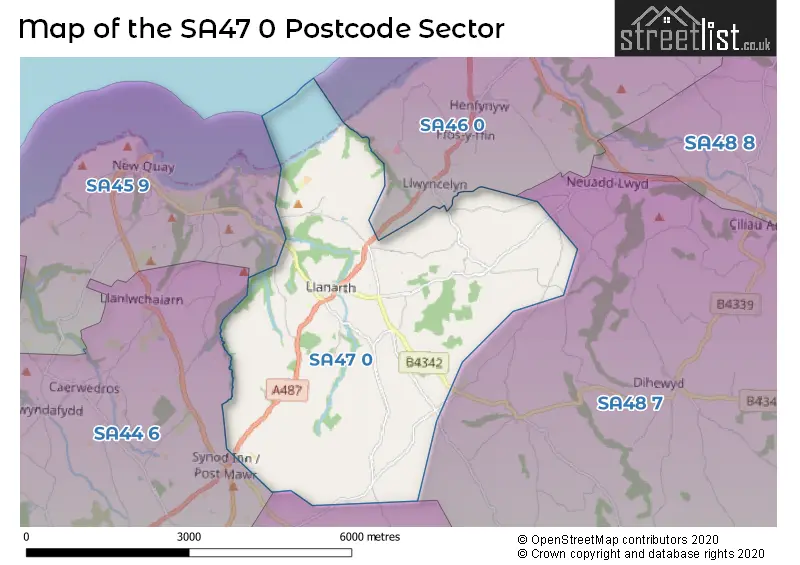
The SA47 0 Postcode shares a border with SA44 4 (LLANDYSUL, TALGARREG, RHYDOWEN), SA48 7 (LAMPETER, LLANWNNEN, CRIBYN), SA44 6 (LLANGRANNOG, CROSS INN, SARNAU), SA45 9 (NEW QUAY, GILFACHRHEDA, MAENYGROES) and SA46 0 (ABERAERON, FFOSYFFIN, LLWYNCELYN).
Map of the SA47 0 Postcode Sector
Explore the SA47 0 postcode sector by using our interactive map.
The sector is within the post town of LLANARTH.
SA47 0 is a postcode sector within the SA47 postcode district which is within the SA Swansea postcode area.
The Royal Mail delivery office for the SA47 0 postal sector is the Lampeter Delivery Office.
The area of the SA47 0 postcode sector is 10.25 square miles which is 26.56 square kilometres or 6,562.99 square acres.
Your support helps keep this site running!
If you enjoy using this website, consider buying me a coffee to help cover hosting costs.

| S | A | 4 | 7 | - | 0 | X | X |
| S | A | 4 | 7 | Space | 0 | Letter | Letter |
Official List of Streets
Unofficial Streets or Alternative Spellings
Weather Forecast for SA47 0
Weather Forecast for New Quay (Harbour Beach)
House Prices in the SA47 0 Postcode Sector
| Type of Property | 2018 Average | 2018 Sales | 2017 Average | 2017 Sales | 2016 Average | 2016 Sales | 2015 Average | 2015 Sales |
|---|---|---|---|---|---|---|---|---|
| Detached | £242,318 | 11 | £197,083 | 6 | £189,611 | 9 | £162,429 | 7 |
| Semi-Detached | £0 | 0 | £147,390 | 5 | £145,000 | 3 | £104,000 | 2 |
| Terraced | £131,550 | 4 | £105,250 | 2 | £68,000 | 1 | £130,500 | 3 |
| Flats | £0 | 0 | £0 | 0 | £0 | 0 | £0 | 0 |
Important Postcodes SA47 0 in the Postcode Sector
SA47 0PA is the postcode for Llanarth Cp School
| The SA47 0 Sector is within these Local Authorities |
|
|---|---|
| The SA47 0 Sector is within these Counties |
|
| The SA47 0 Sector is within these Water Company Areas |
|