A wide range of spatial data has been analysed to present this overview of the SA1 6 Postcode sector. If you would like anything added, please contact us.
The SA1 6 postcode sector is within the county of West Glamorgan.
Did you know? According to the 2021 Census, the SA1 6 postcode sector is home to a bustling 14,629 residents!
Given that each sector allows for 400 unique postcode combinations. Letters C, I, K, M, O and V are not allowed in the last two letters of a postcode. With 274 postcodes already in use, this leaves 126 units available.
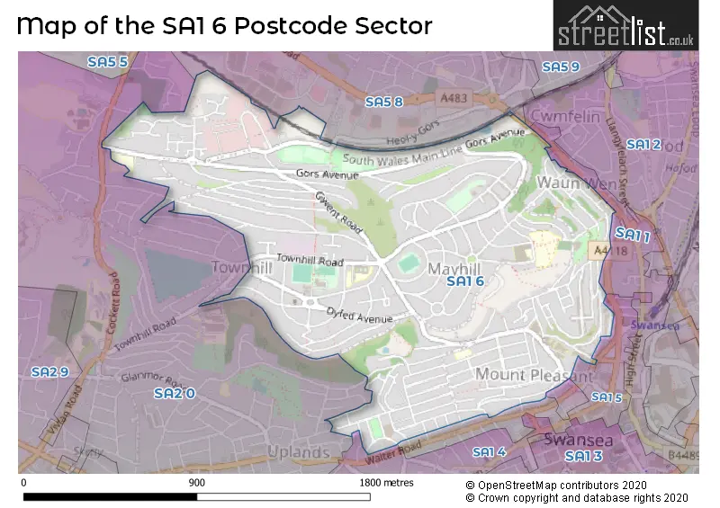
The largest settlement in the SA1 6 postal code is TOWNHILL followed by MOUNT PLEASANT, and MAYHILL.
The SA1 6 Postcode shares a border with SA1 1 (MARITIME QUARTER, CITY CENTRE, WAUN WEN), SA1 2 (HAFOD, LANDORE, WAUN WEN), SA5 8 (GENDROS, MANSELTON, CWMBWRLA), SA2 0 (UPLANDS, BRYNMILL, COCKETT), SA1 3 (CITY CENTRE, SANDFIELDS, MARITIME QUARTER), SA1 4 (BRYNMILL, SANDFIELDS, CENTRAL SWANSEA) and SA1 5 (CITY CENTRE, MOUNT PLEASANT, SWANSEA).
Map of the SA1 6 Postcode Sector
Explore the SA1 6 postcode sector by using our interactive map.
The sector is within the post town of SWANSEA.
SA1 6 is a postcode sector within the SA1 postcode district which is within the SA Swansea postcode area.
The Royal Mail delivery office for the SA1 6 postal sector is the Swansea Delivery Office.
The area of the SA1 6 postcode sector is 1.10 square miles which is 2.84 square kilometres or 701.80 square acres.
Your support helps keep this site running!
If you enjoy using this website, consider buying me a coffee to help cover hosting costs.


| S | A | 1 | - | 6 | X | X |
| S | A | 1 | Space | 6 | Letter | Letter |
Official List of Streets
Mayhill (32 Streets)
SWANSEA (78 Streets)
Townhill (43 Streets)
Unofficial Streets or Alternative Spellings
SWANSEA
ALEXANDRA ROAD BELGRAVE LANE CONVENT STREET CRADOCK STREET PLEASANT STREET BRYN-SYFI TERRACE BRYN-Y-DON ROAD COULTS HILL FURZE BANK GRAIG PLACE GRAIG STREET HANOVER LANE HEOL-Y-GORS LLEWELYN CIRCLE MONTPELLIER TERRACE PANT-Y-CELYN ROAD PARADISE VIEW PEN-Y-GRAIG ROAD PRIMROSE HILL PRIMROSE STREET SEA VIEW TERRACE ST JAMESS CRESCENT TAN Y MARIAN ROAD THE COURT YARD THE RAVINE TOWER COURT VERANDAH STREET WAUN-WEN ROAD WEBBONS WAYCockett
COCKETT ROAD ELWY CRESCENT ELWY GARDENS GWYNEDD AVENUE TOWNHILL ROADUplands
HILLSIDE CRESCENT PENLAN CRESCENT RICHMOND MEWS RICHMOND ROADCwmbwrla
CARMARTHEN ROADWeather Forecast for SA1 6
Weather Forecast for Plantasia Swansea
| Time Period | Icon | Description | Temperature | Rain Probability | Wind |
|---|---|---|---|---|---|
| 21:00 to 00:00 | Light rain shower (night) | 7.0°C (feels like 3.0°C) | 44.00% | WNW 16 mph |
| Time Period | Icon | Description | Temperature | Rain Probability | Wind |
|---|---|---|---|---|---|
| 00:00 to 03:00 | Overcast | 7.0°C (feels like 3.0°C) | 10.00% | WNW 13 mph | |
| 03:00 to 06:00 | Clear night | 6.0°C (feels like 3.0°C) | 1.00% | WNW 11 mph | |
| 06:00 to 09:00 | Clear night | 4.0°C (feels like 2.0°C) | 1.00% | NNW 4 mph | |
| 09:00 to 12:00 | Mist | 4.0°C (feels like 2.0°C) | 15.00% | N 4 mph | |
| 12:00 to 15:00 | Cloudy | 7.0°C (feels like 5.0°C) | 6.00% | NE 7 mph | |
| 15:00 to 18:00 | Cloudy | 8.0°C (feels like 5.0°C) | 6.00% | NNE 9 mph | |
| 18:00 to 21:00 | Cloudy | 6.0°C (feels like 3.0°C) | 5.00% | N 11 mph | |
| 21:00 to 00:00 | Cloudy | 5.0°C (feels like 1.0°C) | 4.00% | N 13 mph |
| Time Period | Icon | Description | Temperature | Rain Probability | Wind |
|---|---|---|---|---|---|
| 00:00 to 03:00 | Clear night | 5.0°C (feels like 1.0°C) | 0.00% | N 11 mph | |
| 03:00 to 06:00 | Clear night | 4.0°C (feels like 0.0°C) | 0.00% | NNW 9 mph | |
| 06:00 to 09:00 | Clear night | 3.0°C (feels like 0.0°C) | 0.00% | NNW 9 mph | |
| 09:00 to 12:00 | Sunny day | 4.0°C (feels like 1.0°C) | 0.00% | NNW 9 mph | |
| 12:00 to 15:00 | Sunny day | 7.0°C (feels like 4.0°C) | 0.00% | NW 9 mph | |
| 15:00 to 18:00 | Partly cloudy (day) | 8.0°C (feels like 5.0°C) | 1.00% | WNW 9 mph | |
| 18:00 to 21:00 | Clear night | 5.0°C (feels like 3.0°C) | 0.00% | WNW 7 mph | |
| 21:00 to 00:00 | Clear night | 4.0°C (feels like 2.0°C) | 1.00% | W 4 mph |
| Time Period | Icon | Description | Temperature | Rain Probability | Wind |
|---|---|---|---|---|---|
| 00:00 to 03:00 | Partly cloudy (night) | 5.0°C (feels like 3.0°C) | 2.00% | SW 7 mph | |
| 03:00 to 06:00 | Cloudy | 6.0°C (feels like 3.0°C) | 10.00% | SW 11 mph | |
| 06:00 to 09:00 | Light rain | 7.0°C (feels like 3.0°C) | 48.00% | SW 13 mph | |
| 09:00 to 12:00 | Light rain | 7.0°C (feels like 4.0°C) | 46.00% | W 11 mph | |
| 12:00 to 15:00 | Cloudy | 9.0°C (feels like 6.0°C) | 8.00% | WNW 11 mph | |
| 15:00 to 18:00 | Cloudy | 9.0°C (feels like 7.0°C) | 7.00% | NW 9 mph | |
| 18:00 to 21:00 | Partly cloudy (night) | 7.0°C (feels like 5.0°C) | 6.00% | SE 7 mph | |
| 21:00 to 00:00 | Partly cloudy (night) | 6.0°C (feels like 4.0°C) | 5.00% | ESE 7 mph |
| Time Period | Icon | Description | Temperature | Rain Probability | Wind |
|---|---|---|---|---|---|
| 00:00 to 03:00 | Cloudy | 6.0°C (feels like 3.0°C) | 11.00% | SE 9 mph | |
| 03:00 to 06:00 | Cloudy | 6.0°C (feels like 3.0°C) | 10.00% | SE 11 mph | |
| 06:00 to 09:00 | Cloudy | 6.0°C (feels like 2.0°C) | 11.00% | SE 11 mph | |
| 09:00 to 12:00 | Cloudy | 6.0°C (feels like 3.0°C) | 11.00% | SE 13 mph | |
| 12:00 to 15:00 | Cloudy | 8.0°C (feels like 4.0°C) | 11.00% | SE 13 mph | |
| 15:00 to 18:00 | Cloudy | 8.0°C (feels like 5.0°C) | 13.00% | SE 13 mph | |
| 18:00 to 21:00 | Cloudy | 8.0°C (feels like 4.0°C) | 16.00% | SSE 16 mph | |
| 21:00 to 00:00 | Cloudy | 8.0°C (feels like 4.0°C) | 19.00% | SSE 16 mph |
House Prices in the SA1 6 Postcode Sector
| Type of Property | 2018 Average | 2018 Sales | 2017 Average | 2017 Sales | 2016 Average | 2016 Sales | 2015 Average | 2015 Sales |
|---|---|---|---|---|---|---|---|---|
| Detached | £134,624 | 4 | £159,624 | 8 | £168,333 | 9 | £145,522 | 9 |
| Semi-Detached | £114,963 | 27 | £104,424 | 40 | £112,402 | 34 | £84,136 | 33 |
| Terraced | £107,865 | 117 | £99,136 | 120 | £97,245 | 102 | £91,409 | 127 |
| Flats | £107,667 | 3 | £80,125 | 8 | £38,714 | 7 | £80,490 | 10 |
Important Postcodes SA1 6 in the Postcode Sector
SA1 6ED is the postcode for FADE, Trinity Saint David-Swansea, Mount Pleasant Campus, CADOGAN CENTRE, Trinity Saint David-Swansea, Mount Pleasant Campus, ADEILAD DYLAN THOMAS, Trinity Saint David-Swansea, Mount Pleasant Campus, OLD ELECTRICAL ENG. BLOCK, Trinity Saint David-Swansea, Mount Pleasant Campus, Trinity Saint David-Swansea, Mount Pleasant Campus, BUSINESS LIBRARY, Trinity Saint David-Swansea, Mount Pleasant Campus, REDBRICK BUILDING, Trinity Saint David-Swansea, Mount Pleasant Campus, GEO. THOMPSON BLOCK, Trinity Saint David-Swansea, Mount Pleasant Campus, NEUADD DYLAN THOMAS, Trinity Saint David-Swansea, Mount Pleasant Campus, and BUSINESS & ADMIN BLOCK, Trinity Saint David-Swansea, Mount Pleasant Campus
SA1 6JD is the postcode for Terrace Road Primary School, Terrace Road
SA1 6PH is the postcode for Townhill Community Centre, Powys Avenue, Townhill
SA1 6PT is the postcode for Kitchen, Townhill Community School, Townhill Road, Main Building, Townhill Community School, Townhill Road, and Townhill Community School, Townhill Road
SA1 6SA is the postcode for Gors Avenue Community Centre, Heol y Gors
SA1 6SF is the postcode for MAIN BLOCK, Gors Community School, Gors Avenue
SA1 6TZ is the postcode for MAIN BLOCK, Seaview Community School, Creidiol Road
| The SA1 6 Sector is within these Local Authorities |
|
|---|---|
| The SA1 6 Sector is within these Counties |
|
| The SA1 6 Sector is within these Water Company Areas |
|