A wide range of spatial data has been analysed to present this overview of the S75 2 Postcode sector. If you would like anything added, please contact us.
The S75 2 postcode sector is within the county of South Yorkshire.
Did you know? According to the 2021 Census, the S75 2 postcode sector is home to a bustling 8,374 residents!
Given that each sector allows for 400 unique postcode combinations. Letters C, I, K, M, O and V are not allowed in the last two letters of a postcode. With 238 postcodes already in use, this leaves 162 units available.
The largest settlements in the S75 2 postal code are BARNSLEY and Gawber.
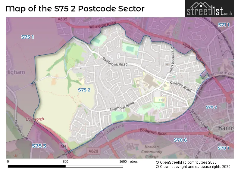
The S75 2 Postcode shares a border with S70 6 (BARNSLEY, Worsbrough), S70 2 (BARNSLEY), S75 1 (BARNSLEY, Barugh Green, Higham) and S75 3 (Dodworth, Tankersley, Hood Green).
Map of the S75 2 Postcode Sector
Explore the S75 2 postcode sector by using our interactive map.
The sector is within the post town of BARNSLEY.
S75 2 is a postcode sector within the S75 postcode district which is within the S Sheffield postcode area.
The Royal Mail delivery office for the S75 2 postal sector is the Barnsley Delivery Office.
The area of the S75 2 postcode sector is 1.04 square miles which is 2.70 square kilometres or 668.12 square acres.
The S75 2 postcode sector is crossed by the M1 motorway.
Your support helps keep this site running!
If you enjoy using this website, consider buying me a coffee to help cover hosting costs.


| S | 7 | 5 | - | 2 | X | X |
| S | 7 | 5 | Space | 2 | Letter | Letter |
Official List of Streets
BARNSLEY (146 Streets)
Gawber (3 Streets)
Unofficial Streets or Alternative Spellings
Weather Forecast for S75 2
Weather Forecast for Barnsley
| Time Period | Icon | Description | Temperature | Rain Probability | Wind |
|---|---|---|---|---|---|
| 03:00 to 06:00 | Partly cloudy (night) | 6.0°C (feels like 3.0°C) | 1.00% | SSW 7 mph | |
| 06:00 to 09:00 | Partly cloudy (night) | 5.0°C (feels like 3.0°C) | 1.00% | SSW 7 mph | |
| 09:00 to 12:00 | Partly cloudy (day) | 5.0°C (feels like 2.0°C) | 1.00% | SSW 7 mph | |
| 12:00 to 15:00 | Cloudy | 8.0°C (feels like 5.0°C) | 4.00% | SSW 11 mph | |
| 15:00 to 18:00 | Cloudy | 8.0°C (feels like 6.0°C) | 5.00% | SSW 9 mph | |
| 18:00 to 21:00 | Cloudy | 7.0°C (feels like 4.0°C) | 5.00% | S 9 mph | |
| 21:00 to 00:00 | Cloudy | 7.0°C (feels like 3.0°C) | 5.00% | S 11 mph |
| Time Period | Icon | Description | Temperature | Rain Probability | Wind |
|---|---|---|---|---|---|
| 00:00 to 03:00 | Cloudy | 6.0°C (feels like 3.0°C) | 5.00% | S 11 mph | |
| 03:00 to 06:00 | Cloudy | 6.0°C (feels like 3.0°C) | 5.00% | SSW 13 mph | |
| 06:00 to 09:00 | Cloudy | 7.0°C (feels like 3.0°C) | 5.00% | SSW 16 mph | |
| 09:00 to 12:00 | Cloudy | 8.0°C (feels like 4.0°C) | 8.00% | SSW 16 mph | |
| 12:00 to 15:00 | Cloudy | 9.0°C (feels like 6.0°C) | 20.00% | SSW 16 mph | |
| 15:00 to 18:00 | Light rain | 9.0°C (feels like 6.0°C) | 56.00% | SSW 13 mph | |
| 18:00 to 21:00 | Partly cloudy (night) | 8.0°C (feels like 6.0°C) | 14.00% | SW 11 mph | |
| 21:00 to 00:00 | Clear night | 7.0°C (feels like 4.0°C) | 4.00% | WSW 11 mph |
| Time Period | Icon | Description | Temperature | Rain Probability | Wind |
|---|---|---|---|---|---|
| 00:00 to 03:00 | Clear night | 6.0°C (feels like 2.0°C) | 2.00% | WSW 11 mph | |
| 03:00 to 06:00 | Clear night | 5.0°C (feels like 2.0°C) | 2.00% | WSW 9 mph | |
| 06:00 to 09:00 | Clear night | 4.0°C (feels like 1.0°C) | 2.00% | WSW 9 mph | |
| 09:00 to 12:00 | Partly cloudy (day) | 4.0°C (feels like 2.0°C) | 2.00% | WSW 7 mph | |
| 12:00 to 15:00 | Cloudy | 7.0°C (feels like 4.0°C) | 4.00% | W 9 mph | |
| 15:00 to 18:00 | Partly cloudy (day) | 7.0°C (feels like 5.0°C) | 1.00% | W 9 mph | |
| 18:00 to 21:00 | Clear night | 4.0°C (feels like 2.0°C) | 1.00% | W 4 mph | |
| 21:00 to 00:00 | Clear night | 3.0°C (feels like 1.0°C) | 1.00% | W 4 mph |
| Time Period | Icon | Description | Temperature | Rain Probability | Wind |
|---|---|---|---|---|---|
| 00:00 to 03:00 | Clear night | 2.0°C (feels like 0.0°C) | 1.00% | W 4 mph | |
| 03:00 to 06:00 | Clear night | 1.0°C (feels like -1.0°C) | 1.00% | W 4 mph | |
| 06:00 to 09:00 | Clear night | 0.0°C (feels like -2.0°C) | 1.00% | W 2 mph | |
| 09:00 to 12:00 | Sunny day | 1.0°C (feels like -1.0°C) | 3.00% | WSW 2 mph | |
| 12:00 to 15:00 | Sunny day | 5.0°C (feels like 4.0°C) | 1.00% | E 2 mph | |
| 15:00 to 18:00 | Sunny day | 7.0°C (feels like 5.0°C) | 1.00% | E 4 mph | |
| 18:00 to 21:00 | Clear night | 3.0°C (feels like 2.0°C) | 1.00% | ENE 4 mph | |
| 21:00 to 00:00 | Clear night | 2.0°C (feels like 0.0°C) | 1.00% | E 4 mph |
Schools and Places of Education Within the S75 2 Postcode Sector
Gawber Primary School
Community school
Church Street, Barnsley, South Yorkshire, S75 2RJ
Head: Mrs Dawn Bradshaw
Ofsted Rating: Outstanding
Inspection: 2013-02-21 (4365 days ago)
Website: Visit Gawber Primary School Website
Phone: 01226289728
Number of Pupils: 213
St Mary's Church of England Primary School, Barnsley
Academy converter
Stocks Lane, Barnsley, South Yorkshire, S75 2DF
Head: Mr Lee Spencer
Ofsted Rating: Outstanding
Inspection: 2013-02-20 (4366 days ago)
Website: Visit St Mary's Church of England Primary School, Barnsley Website
Phone: 01226206422
Number of Pupils: 217
Summer Lane Primary
Community school
Summer Lane, Barnsley, South Yorkshire, S75 2BB
Head: Mr Rob Smith
Ofsted Rating: Good
Inspection: 2023-11-16 (445 days ago)
Website: Visit Summer Lane Primary Website
Phone: 01226205363
Number of Pupils: 311
House Prices in the S75 2 Postcode Sector
| Type of Property | 2018 Average | 2018 Sales | 2017 Average | 2017 Sales | 2016 Average | 2016 Sales | 2015 Average | 2015 Sales |
|---|---|---|---|---|---|---|---|---|
| Detached | £226,265 | 66 | £229,000 | 35 | £237,823 | 34 | £207,274 | 37 |
| Semi-Detached | £132,348 | 65 | £132,007 | 55 | £134,780 | 54 | £130,471 | 48 |
| Terraced | £101,016 | 52 | £98,290 | 44 | £108,838 | 51 | £90,429 | 35 |
| Flats | £72,083 | 6 | £82,828 | 9 | £91,000 | 5 | £64,040 | 2 |
Important Postcodes S75 2 in the Postcode Sector
S75 2AH is the postcode for 33, Gawber Road
S75 2BB is the postcode for Summer Lane Primary School, Summer Lane
S75 2DF is the postcode for St. Marys C of E Primary School, Stocks Lane, ST MARYS CHURCH OF ENGLAND PRIMARY ACADEMY, STOCKS LANE, BARNSLEY, and St Marys Church Of England Primary Academy, Stocks Lane
S75 2EP is the postcode for AREA R+S, Barnsley District General Hospital, Pogmoor Road, AREA V+W, Barnsley District General Hospital, Pogmoor Road, Barnsley PCT, Barnsley DGH, AREA K+L, Barnsley District General Hospital, Pogmoor Road, AREA P+Q, Barnsley District General Hospital, Pogmoor Road, AREA E+F, Barnsley District General Hospital, Pogmoor Road, AREA G+H, Barnsley District General Hospital, Pogmoor Road, AREA M + N, Barnsley District General Hospital, Pogmoor Road, RENAL UNIT BUILDING, Barnsley District General Hospital, Pogmoor Road, NTU, Barnsley District General Hospital, Pogmoor Road, A+B BLOCK, Barnsley District General Hospital, Pogmoor Road, BARNSLEY DISTRICT GENERAL HOSPITAL, GAWBER ROAD, OLD TOWN, GDU, Barnsley District General Hospital, Pogmoor Road, MATERNITY, Barnsley District General Hospital, Pogmoor Road, EDUCATION UNIT (OLD NTU), Barnsley District General Hospital, Pogmoor Road, Barnsley District General Hospital, Pogmoor Road, and AREA T+U, Barnsley District General Hospital, Pogmoor Road
S75 2PY is the postcode for HILLDER HOUSE, 49-51 Gawber Road, and 49-51 Gawber Road
S75 2RJ is the postcode for Gawber Primary School, Church Street, and GAWBER PRIMARY SCHOOL, CHURCH STREET, GAWBER
| The S75 2 Sector is within these Local Authorities |
|
|---|---|
| The S75 2 Sector is within these Counties |
|
| The S75 2 Sector is within these Water Company Areas |
|