A wide range of spatial data has been analysed to present this overview of the S71 2 Postcode sector. If you would like anything added, please contact us.
The S71 2 postcode sector is within the county of South Yorkshire.
Did you know? According to the 2021 Census, the S71 2 postcode sector is home to a bustling 9,368 residents!
Given that each sector allows for 400 unique postcode combinations. Letters C, I, K, M, O and V are not allowed in the last two letters of a postcode. With 240 postcodes already in use, this leaves 160 units available.
The largest settlements in the S71 2 postal code are BARNSLEY and Monk Bretton.
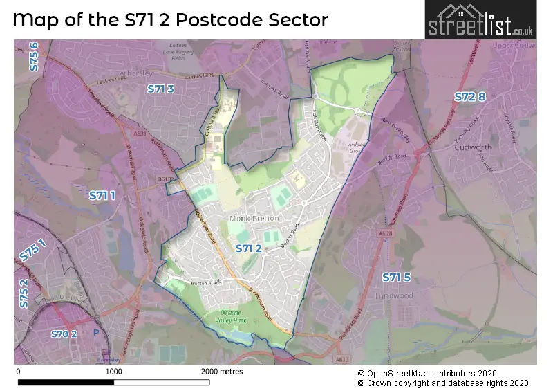
The S71 2 Postcode shares a border with S70 3 (BARNSLEY, Kendray, Stairfoot), S71 3 (BARNSLEY, Carlton, New Lodge), S71 1 (BARNSLEY) and S71 5 (BARNSLEY, Lundwood, Ardsley).
Map of the S71 2 Postcode Sector
Explore the S71 2 postcode sector by using our interactive map.
The sector is within the post town of BARNSLEY.
S71 2 is a postcode sector within the S71 postcode district which is within the S Sheffield postcode area.
The Royal Mail delivery office for the S71 2 postal sector is the Barnsley Delivery Office.
The area of the S71 2 postcode sector is 1.47 square miles which is 3.82 square kilometres or 943.21 square acres.
Waterways within the S71 2 postcode sector include the River Dearne.
Your support helps keep this site running!
If you enjoy using this website, consider buying me a coffee to help cover hosting costs.


| S | 7 | 1 | - | 2 | X | X |
| S | 7 | 1 | Space | 2 | Letter | Letter |
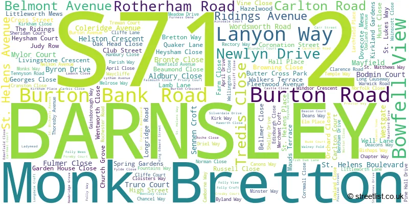
Official List of Streets
BARNSLEY (157 Streets)
(11 Streets)
Unofficial Streets or Alternative Spellings
Weather Forecast for S71 2
Weather Forecast for Barnsley Fc
| Time Period | Icon | Description | Temperature | Rain Probability | Wind |
|---|---|---|---|---|---|
| 03:00 to 06:00 | Overcast | 3.0°C (feels like 2.0°C) | 9.00% | SSW 2 mph | |
| 06:00 to 09:00 | Cloudy | 3.0°C (feels like 1.0°C) | 10.00% | S 4 mph | |
| 09:00 to 12:00 | Cloudy | 3.0°C (feels like 1.0°C) | 8.00% | SSW 4 mph | |
| 12:00 to 15:00 | Cloudy | 4.0°C (feels like 2.0°C) | 7.00% | SSW 4 mph | |
| 15:00 to 18:00 | Cloudy | 5.0°C (feels like 3.0°C) | 7.00% | S 4 mph | |
| 18:00 to 21:00 | Cloudy | 3.0°C (feels like 1.0°C) | 7.00% | S 4 mph | |
| 21:00 to 00:00 | Cloudy | 2.0°C (feels like 0.0°C) | 7.00% | S 4 mph |
| Time Period | Icon | Description | Temperature | Rain Probability | Wind |
|---|---|---|---|---|---|
| 00:00 to 03:00 | Cloudy | 2.0°C (feels like 0.0°C) | 8.00% | S 4 mph | |
| 03:00 to 06:00 | Cloudy | 1.0°C (feels like -1.0°C) | 8.00% | SSE 2 mph | |
| 06:00 to 09:00 | Mist | 1.0°C (feels like -1.0°C) | 17.00% | SE 2 mph | |
| 09:00 to 12:00 | Fog | 1.0°C (feels like -1.0°C) | 18.00% | ESE 2 mph | |
| 12:00 to 15:00 | Mist | 2.0°C (feels like 0.0°C) | 18.00% | NE 2 mph | |
| 15:00 to 18:00 | Overcast | 3.0°C (feels like 1.0°C) | 12.00% | NE 4 mph | |
| 18:00 to 21:00 | Overcast | 2.0°C (feels like 1.0°C) | 12.00% | NNE 2 mph | |
| 21:00 to 00:00 | Overcast | 2.0°C (feels like 0.0°C) | 15.00% | N 4 mph |
| Time Period | Icon | Description | Temperature | Rain Probability | Wind |
|---|---|---|---|---|---|
| 00:00 to 03:00 | Overcast | 2.0°C (feels like 0.0°C) | 17.00% | NNW 4 mph | |
| 03:00 to 06:00 | Overcast | 2.0°C (feels like 0.0°C) | 19.00% | NW 4 mph | |
| 06:00 to 09:00 | Overcast | 2.0°C (feels like 0.0°C) | 17.00% | WNW 4 mph | |
| 09:00 to 12:00 | Cloudy | 2.0°C (feels like 0.0°C) | 13.00% | WSW 7 mph | |
| 12:00 to 15:00 | Partly cloudy (day) | 4.0°C (feels like 2.0°C) | 8.00% | WSW 7 mph | |
| 15:00 to 18:00 | Cloudy | 5.0°C (feels like 3.0°C) | 11.00% | SW 7 mph | |
| 18:00 to 21:00 | Cloudy | 4.0°C (feels like 1.0°C) | 9.00% | SW 7 mph | |
| 21:00 to 00:00 | Cloudy | 3.0°C (feels like 1.0°C) | 7.00% | SW 7 mph |
Schools and Places of Education Within the S71 2 Postcode Sector
Burton Road Primary School
Community school
Old Mill, Barnsley, South Yorkshire, S71 2AA
Head: Mr M Harris
Ofsted Rating: Good
Inspection: 2023-10-18 (461 days ago)
Website: Visit Burton Road Primary School Website
Phone: 01226288679
Number of Pupils: 361
Holy Trinity Catholic and Church of England School
Academy sponsor led
Carlton Road, Barnsley, South Yorkshire, S71 2LF
Head: Mrs Lissa Oldcorn
Ofsted Rating: Requires improvement
Inspection: 2022-09-22 (852 days ago)
Website: Visit Holy Trinity Catholic and Church of England School Website
Phone: 01226704550
Number of Pupils: 1109
Springwell Alternative Academy
Academy alternative provision converter
St Helen's Boulevard, Barnsley, South Yorkshire, S71 2AY
Head: Natalie Myers
Ofsted Rating: Good
Inspection: 2023-05-05 (627 days ago)
Website: Visit Springwell Alternative Academy Website
Phone: 01226291133
Number of Pupils: 56
Springwell Special Academy
Academy special converter
St Helen's Boulevard, Barnsley, South Yorkshire, S71 2AY
Head: Lydia Harrison
Ofsted Rating: Good
Inspection: 2022-03-09 (1049 days ago)
Website: Visit Springwell Special Academy Website
Phone: 01226291133
Number of Pupils: 108
St Helen's Primary Academy
Academy sponsor led
St Helen's Way, Barnsley, , S71 2PS
Head: Miss Victoria Gorton
Ofsted Rating: Requires improvement
Inspection: 2020-01-15 (1833 days ago)
Website: Visit St Helen's Primary Academy Website
Phone: 01226295210
Number of Pupils: 219

House Prices in the S71 2 Postcode Sector
| Type of Property | 2018 Average | 2018 Sales | 2017 Average | 2017 Sales | 2016 Average | 2016 Sales | 2015 Average | 2015 Sales |
|---|---|---|---|---|---|---|---|---|
| Detached | £218,029 | 73 | £194,792 | 60 | £170,324 | 28 | £165,455 | 36 |
| Semi-Detached | £125,406 | 66 | £116,117 | 85 | £109,110 | 82 | £106,955 | 49 |
| Terraced | £87,845 | 33 | £91,562 | 30 | £95,629 | 19 | £99,597 | 20 |
| Flats | £57,050 | 10 | £59,667 | 3 | £59,375 | 4 | £67,273 | 3 |
Important Postcodes S71 2 in the Postcode Sector
S71 2AA is the postcode for Burton Road Nursery School, Burton Road, and BURTON ROAD PRIMARY SCHOOL, BURTON ROAD
S71 2AY is the postcode for Holy Cross Deanery CE (Va) Primary School, St. Helens Boulevard, Barnsley Metropolitan Borough Council, St. Helens Boulevard, and Springwell Community School, St. Helens Boulevard
S71 2BE is the postcode for St. Dominics Catholic Primary School, Carlton Road
S71 2DY is the postcode for Belmont Induction Centre, Cross Street
S71 2EQ is the postcode for Monk Bretton Health Centre, High Street
S71 2LF is the postcode for Holy Trinity Advanced Learning Centre, Carlton Road, and HOLY TRINITY ADVANCED LEARNING CENTRE, CARLTON ROAD, ATHERSLEY SOUTH
S71 2PS is the postcode for St. Helens Primary Academy, St. Helens Way, Monk Bretton, and St. Helens Primary, St. Helens Way
| The S71 2 Sector is within these Local Authorities |
|
|---|---|
| The S71 2 Sector is within these Counties |
|
| The S71 2 Sector is within these Water Company Areas |
|